


 15 / 34

Page 43
conferenceseries
.com
Volume 6, Issue 2 (Suppl)
J Aeronaut Aerospace Eng
ISSN: 2168-9792 JAAE, an open access journal
Satellite 2017
May 11-13, 2017
May 11-13, 2017 Barcelona, Spain
3
rd
International Conference and Exhibition on
Satellite & Space Missions
Micro-satellite hosted laser-gated systemfor space debris tracking, forest fires andplants’healthmonitoring
and underground facilities location
Yavor Yossifov Shopov
1
, Ognyan Ognyanov
2
and
Plamen Dankov
1
1
Sofia University, Bulgaria
2
O & K Co., Bulgaria
H
ere, we propose a space platform integrating telescope with an interchangeable head holding five receptors: NIR, MIR, FIR
and VIS cameras and laser range meter. Such construction is very appropriate for using on micro satellites and space probes
because it is much more compact and light than conventional payload with separate optics for each receptor. It allows high resolution
imaging for Normalized Difference Vegetation Index (NDVI) estimation of the wilting (water loss) of the vegetation to determine the
degree of drying of plant, for monitoring the state of health of the vegetation, for early tracing of illness of plants, and to determine
fire hazardous areas of dry vegetation in order to prevent forest fires. It is very useful for: prediction of forest fires; natural disaster
warning; accurate determination of the area of the forest fire-affected areas and to monitor fire hazard areas of dry vegetation. Most
effective and precise method for remote localization of forest fires is with mid-IR (MIR) camera, mounted on board of an unmanned
aerial vehicle (UAV) or high resolution satellite. MIR camera sees clearly the hot spot of the fire even through dense smoke which is
impossible for observations in the visible range of the spectra. Therefore, they are particularly useful for localization of the hot spots
of forest fires and their extension. FIR camera allows location of entrances of underground facilities due to temperature difference of
the ambient air and this coming from the facility. At the same time laser ranging is very useful for space surveillance and tracking of
space debris, etc. Laser-gated imaging for debris observation/detection use common telescope with other cameras.
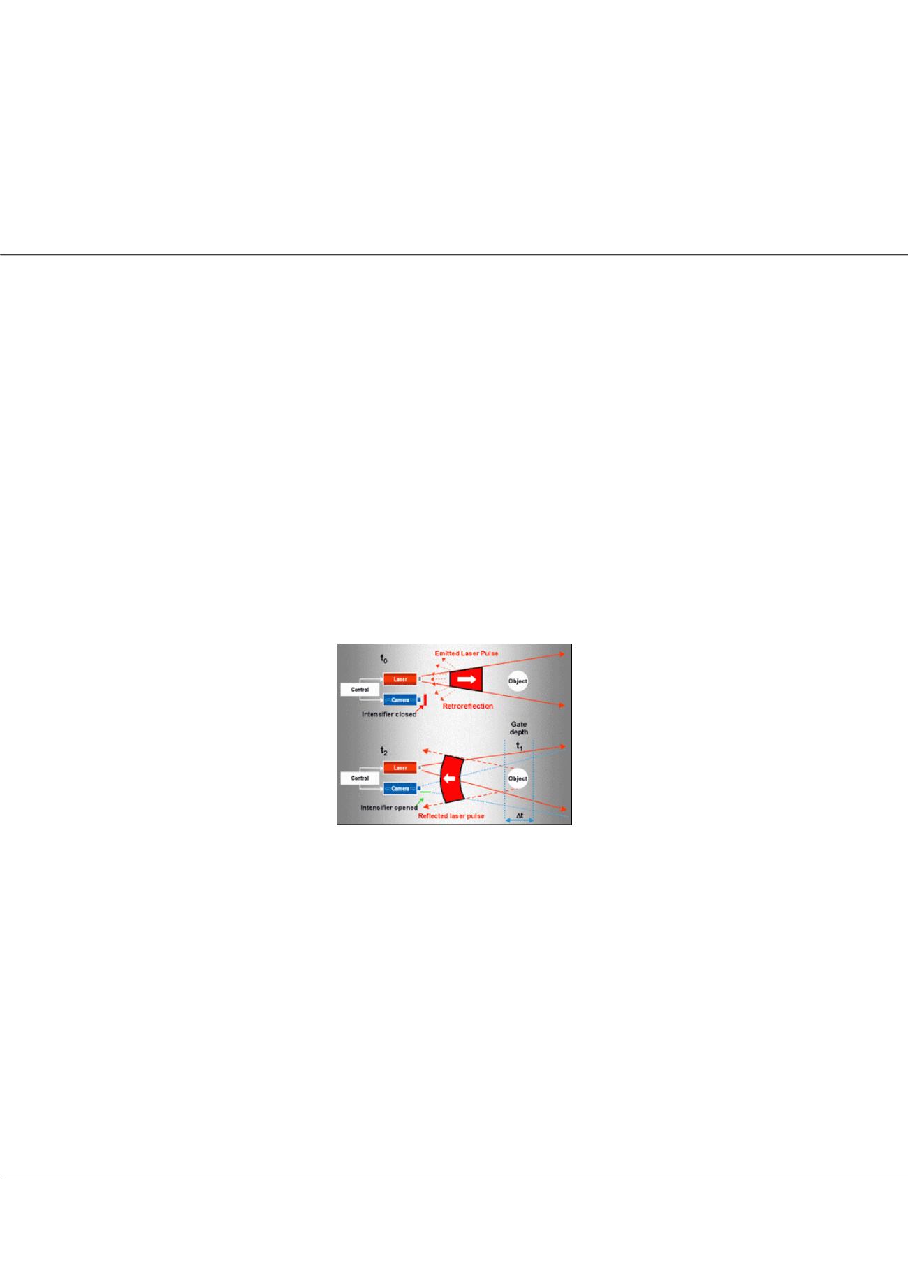
Figure 1:
Principle of laser-gated scan camera object detection. The imaging sensor or “global-shutter” scan-gated camera
“opens the gate” (i.e., starts the exposure) after a certain time (gate) delay for a very short period of time (gate width).
Therefore, the sensor is not influenced by scattered photons or parasitic light sources. Only the photons that arrive within the
gate width contribute to the resulting image. The gate delay determines the position of the detection debris object, and the
camera gating time (exposure time) will define the depth of view (range depth). Therefore, the resulting image consists of
information only from reflected light at the distance of interest. Changing the gate delay by a selected step, the camera can
perform quite informative 3-D imaging of the possible space debris object at different distances along a given direction.
Biography
Yavor Yossifov Shopov has completed his PhD at Sofia University, Bulgaria and Post-doctoral studies at McMaster University, Canada. He is Head of University
Centre for Space Research & Technologies, Sofia University. He is a Supervisor of Master Programme on aerospace engineering of small satellites at Sofia
University. He has published more than 100 papers in reputed journals and has been serving as an Editorial Board Member of repute. His research interest
includes “Applications of satellites in applied and fundamental research, space physics and solar-terrestrial physics, design and development of optical and spectral
equipment for photographic observations and photometry in different regions of the spectrum”.
YYShopov@yahoo.comYavor Yossifov Shopov et al., J Aeronaut Aerospace Eng 2017, 6:2(Suppl)
http://dx.doi.org/10.4172/2168-9792-C1-016