 Spanish
  Chinese
  Russian
  German
  French
  Japanese
  Portuguese
  Hindi
Hindi Our Group organises 3000+ Global Conferenceseries Events every year across USA, Europe & Asia with support from 1000 more scientific Societies and Publishes 700+ Open Access Journals which contains over 50000 eminent personalities, reputed scientists as editorial board members.
Open Access Journals gaining more Readers and Citations
700 Journals and 15,000,000 Readers Each Journal is getting 25,000+ Readers
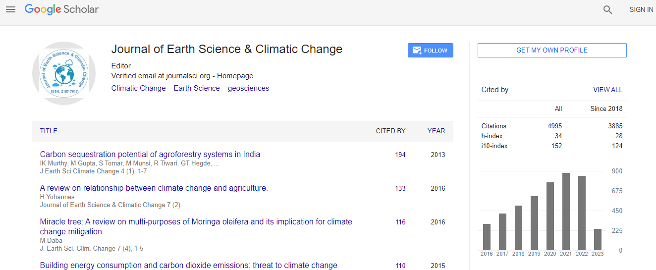
Google Scholar citation report
Citations : 5125
Journal of Earth Science & Climatic Change received 5125 citations as per Google Scholar report
Journal of Earth Science & Climatic Change peer review process verified at publons

Indexed In
- CAS Source Index (CASSI)
- Index Copernicus
- Google Scholar
- Sherpa Romeo
- Online Access to Research in the Environment (OARE)
- Open J Gate
- Genamics JournalSeek
- JournalTOCs
- Ulrich's Periodicals Directory
- Access to Global Online Research in Agriculture (AGORA)
- Centre for Agriculture and Biosciences International (CABI)
- RefSeek
- Hamdard University
- EBSCO A-Z
- OCLC- WorldCat
- Proquest Summons
- SWB online catalog
- Publons
- Euro Pub
- ICMJE
Useful Links
Recommended Journals
Related Subjects
Share This Page
In Association with

Flood and inundation space monitoring assessment on Akmola region based on KazEOSat-1, 2 Kazakhstan spacecraft remote sensing data usage
6th Global summit on Climate Change
Dana Tuleukulova
Kazakhstan Gharysh Sapary, The Republic of Kazakhstan
ScientificTracks Abstracts: J Earth Sci Clim Change
Abstract
Situation distance control after flood and inundation is one of the main problems to be solved by space monitoring of emergency situations, developed in Kazakhstan since 2001. There is an acute security issue during spring time inundation, till nowadays there is no science-based methodology for predicting and modeling of flood and inundation using modern methods of GIS- projecting and update remote sensing data. The ongoing development of own space remote sensing system, usage of KazEOSat-1, 2 space craft data for inundation modeling and predicting, authenticity models studying, and DEM construction are the basis for scientific research in hydrological modeling of inundation. Dynamics of terrain flooding and the identification of areas for evacuating the population and moving cattle can be shown in the program. Flat relief models of flooding have been developed similar to the relief of Northern Kazakhstan. Created DEMs are filled with a filling step of 1 meter in height colors due to spatial resolution of the original DTM and the step of the relief heights for every 1 meter in the cartesian coordinate system from KazEOSat-1, 2 spacecraft remote sensing data.Biography
Dana Tuleukulova has completed her Bachelor's and Master's degrees from Karaganda State Technical University. She has been working at Kazakhstan Gharysh Sapary, since November 01, 2017 as the Major Specialist at Geo-services department in geo-products bureau of Geo-informationData and Services Center. She has published one paper in a reputed journal.
E-mail: d.tuleukulova@gharysh.kz