Our Group organises 3000+ Global Conferenceseries Events every year across USA, Europe & Asia with support from 1000 more scientific Societies and Publishes 700+ Open Access Journals which contains over 50000 eminent personalities, reputed scientists as editorial board members.

Open Access Journals gaining more Readers and Citations
700 Journals and 15,000,000 Readers Each Journal is getting 25,000+ Readers

This Readership is 10 times more when compared to other Subscription Journals (Source: Google Analytics)
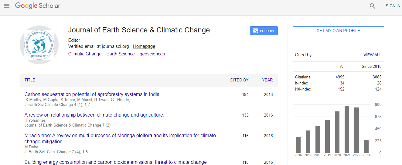
Google Scholar citation report
Citations : 5125

Journal of Earth Science & Climatic Change received 5125 citations as per Google Scholar report

Journal of Earth Science & Climatic Change peer review process verified at publons
Indexed In
  • CAS Source Index (CASSI)
  • Index Copernicus
  • Google Scholar
  • Sherpa Romeo
  • Online Access to Research in the Environment (OARE)
  • Open J Gate
  • Genamics JournalSeek
  • JournalTOCs
  • Ulrich's Periodicals Directory
  • Access to Global Online Research in Agriculture (AGORA)
  • Centre for Agriculture and Biosciences International (CABI)
  • RefSeek
  • Hamdard University
  • EBSCO A-Z
  • OCLC- WorldCat
  • Proquest Summons
  • SWB online catalog
  • Publons
  • Euro Pub
  • ICMJE
Share This Page

Evaluation of rainfall-induced landslide potential due to land use in the slope

4th International Conference on Earth Science & Climate Change

Yie-Ruey Chen1, Kuang-Jung Tsai1, Jie-Lun Chiang2, Meng-Hsuan Huang1 and Chia-Ching Yu1

Posters-Accepted Abstracts: J Earth Sci Clim Change

DOI: 10.4172/2157-7617.S1.019

Abstract
Recently, because technological and economic development, the original plain area in Taiwan has been nearly fully developed and human development has extended to the hillside area. Human development coupled with the global impact of extreme weather, typhoons and heavy rains caused the hillside disaster. The scope and impact extent of the damage are more serious than ever before. For this reason, evaluation of rainfall-induced landslide potential due to land use is essential to disaster prevention. Based on the situations before and after the attack of typhoon or extreme rainfall events on the study area in Tsengwen catchment of southern Taiwan in recent years, this study applied the architecture of genetic adaptive neural networks combined with image texture analysis and GIS in satellite image interpretation and land use change analysis to obtain surface information and hazard log data. This study applied the optimum seeking method in the quantitative analysis of the weights of the various natural environmental and slope development hazard factors. Then, through GIS the landslide potential map is plotted. In addition, the evaluation processes for landslide potential after rainfall due to slope land use are established. Results of image classification show that the values of coefficient of agreement for different time periods are at intermediatehigh level. The predicted potential of landslide is in reasonable confidence level. The findings of this study can provide a reference for subsequent slope development countermeasures, and the academic and engineering assessment of landslide disasters caused by slope development.
Biography
Yie-Ruey Chen received the BS degree in Civil Engineering from Feng Chia University, Taiwan, in 1983, and the MS degree in Geotechnical Engineering from Louisiana State University, Baton Rouge, in 1990, and the PhD degree in Geotechnical Engineering from the University of California, Davis in 1995. He is a Professor in the Department of Land Management and Development, Chang Jung Christian University, Taiwan.
Relevant Topics
Top