Review Article Open Access
Wildlife Habitat Suitability Analysis at Serengeti National Park (SNP), Tanzania Case Study Loxodonta sp
John Erasto Sanare1, Eltaib S Ganawa1* and Abdelrahim AM Salih2
1Faculty of Geoinformatics, Future University, Khartoum, Sudan
2Remote Sensing Authority, National Research Centre, Khartoum, Sudan
- *Corresponding Author:
- Eltaib S Ganawa
Faculty of Geoinformatics
Future University
Khartoum, Sudan
Tel: + 002-499-12589116
E-mail: ganawa@uofk.edu
Received Date: May 29, 2015; Accepted Date: July 29, 2015; Published Date: November 12, 2015
Citation: Sanare JE, Ganawa ES, Abdelrahim AMS (2015) Wildlife Habitat Suitability Analysis at Serengeti National Park (SNP), Tanzania Case Study Loxodonta sp. J Ecosys Ecograph 5:164. doi:10.4172/2157-7625.1000164
Copyright: © 2015 Sanare JE, et al. This is an open-access article distributed under the terms of the Creative Commons Attribution License, which permits unrestricted use, distribution, and reproduction in any medium, provided the original author and source are credited.
Visit for more related articles at Journal of Ecosystem & Ecography
Abstract
Wildlife management is an issue of global importance where its habitat suitability mapping is an essential for the better management, conservation and protection of these valuable species such as elephants, in Serengeti National park in Tanzania where the environmental, physical and socio-economic structure are not efficiently well managed and monitored, there is highly habitat loss and fragmentation due to various reasons includes the expansion of farms, extension of roads in the remote areas, projects like dams, mines or commercial agriculture like oil-palm plantation. These have decreased the source of food and shelter for elephants. Further the human encroachment has destroyed the corridors of elephants which enabled access to seasonal movement for food, water and salt, also there is decline in elephant species due to hunting, poaching of ivory, In addition other body parts such as bone, hide, hair and teeth are highly valuable for making ornaments. That’s leads the wildlife-human conflicts. In this study, the Analytic Hierarchy process (AHP) and overlay weight analysis in GIS software where used to generate the elephants suitability maps for t the Serengeti National Park in Tanzania. Total of five factors that contribute to the wildlife habitat suitability namely rivers, roads, forests, woodlands and grassing and bush lands where integrated in GIS and AHP was applied to rate the individual classes of the each factor and weight the impact of one factor against the other to determine the weighted contribution of importance to the wildlife habitat suitability, Basically all the five contributing factors for wildlife habitat suitability where converted into raster and combine by using weight Overlays in Arcmap with weights from the AHP which a based on the distribution of each class of habitat factors to generate the final thematic map for elephants suitable habitat map, Finally the thematic map overlaid habitat analysis showed open tress at least (65-40%) crown cover to forest was the most important habitat factor considered elephant in habitat analysis , The forest factor needed to protect body, reproduction area and feeding elephant could not stay long term in open area, they needed close forest for protection, resting and sleeping. Conclusively the methodology applied for this study was successfully and it could be adopted in similar environments. GIS and Remote Sensing technologies proved feasible for the wildlife habitat suitability mapping.
Keywords
Habitat; GIS; RS; Wildlife; Shape file; Raster; Buffer; Attributes; Satellite; GPS; Elephants; Management
Introduction
Ecosystem
The place we live in is shared by all the living and non-living beings. Humans are considered as the intelligent being and our environment consists of biotic, a- biotic and artificial factors. Similarly, animals are important aspect of our ecosystem. To maintain a balance of the ecosystem, there should be balance; in the environment we live in today is one of the biggest issue deals with the conservation of wildlife habitat. Habitat of species especially elephants (Loxodonta sp.) are at risk due to changing natural phenomenon and imprudent human actions. It is vague and ambiguous to define the environment of such species, this will use elephant (Loxodonta sp.) habitat as a case study to analyse habitat suitability, by using GIS technology will represent the environmental preferences of such species [1].
It helps to identify the basic factors that specie needs to survive and helps to analyse their response to the changing environment. Geographical Information system GIS and Remote Sensing Technology can be used to find out the species density at existing location or probability of a species to live in a new location with similar characteristics. Mostly habitat modeling is focused on conservation of species and predicting the possible suitable habitat [2].
Brooks [3] defined the term wildlife as applies to all biotic elements that comprise every species of plant and animal in the world, excluding man and his domesticated pets. In past, the term was often used to address a limited number of spectacular animals, which enjoyed public recognition. Wilderness areas and the wildlife habitats in the world are shrinking in time and space due to unprecedented pressure of anthropocentric economic development. Wildlife and human beings coexisted in nature until humans became dominant organisms. The problem is more acute in the developing world, where wildlife and biodiversity conservation is often subordinated to more pressing demands like hunger and poverty. According to Tanzania National Park report [4]. Found that the quickest possible way for inventory and evaluation of the natural resources is through applications of Remote Sensing and GIS technologies. Remotely sensed data provides capabilities for synoptic, frequent, real time and accurate assessment, monitoring and management of natural resources as well as locating a suitable habitat for them [5].
Problem statement
• Habitat destruction and habitat fragmentation are the two biggest threats to most wildlife currently. These have always been a problem and continue to get worse as the populations of wildlife need enough space for survival
• Lack of the clear suitable areas for elephant’s habitats and other endangered species at the Serengeti National Park
Objectives
The main objective of this study is to develop a Wildlife Habitat suitability analysis for elephants at the Serengeti National Park, Tanzania.
The specific objectives are:
1. To consolidate available geospatial and non-spatial data of various environmental and socio-economic attributes for habitat of elephants at the study area
2. To develop a GIS habitat suitability model for elephants at the study area
3. To produce thematic maps of suitable elephants habitats maps at Serengeti National Park
4. To apply the GIS model and assess the various environmental and socio-economic factors that affect the GIS habitat suitability model for elephants
Scope
The scope of this research is involved in Wildlife habitat suitability at Serengeti National park at Tanzania to support decision making to help in locating the suitable area elephant’s s for at Serengeti National park for conserving this valuable species for the future generations through spatially parameters.
Study area
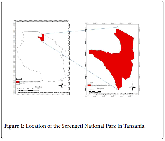
The Project study area is Serengeti National park, which is the most popular and oldest park in Tanzania. According to Tanzania National Park report [4] Serengeti National Park is home to the largest migration of land animals on the planet more than two million mammals roam its 11,500 square miles (30,000 square kilometers). Serengeti National Park (SENEPA) is located between 1° 30' to 3° 20' South and 34° 00' to 35°15' east as shown in Figure 1.
Conceptual framework/Research paradigms
In order to conserve wildlife habitat information on the spatial suitability of the habitat is necessary for more effective policies and planning for these valuable resources, This project will describe the habitats and spatial preferences of elephants (Loxodonta sp.) in Serengeti National Park in Tanzania, This it’s a multi-criteria study whereby it involves more than one input, The inputs are GIS survey elephants (Loxodonta sp.) movement points collected by using GPS , Base map of Serengeti, Landsat and aerial imagery such as Landsat ETM.
Geographic information systems (GIS) have become the promising tool for the information on physical parameters of the wildlife habitats and geospatial modeling for Serengeti National Park habitat Suitability management.
GIS and Remote Sensing
Elephants (Loxodonta sp.)
Changes in wildlife conservation areas have serious implications for ecological systems and elephant’s habitats [3], analyzed long-term land use/cover changes, multitemporal satellite images, together with physical and social economic data were employed in a post classification analysis with GIS to analyse outcomes effects of different land use practices and policies on the elephant’s habitat. The results showed land use/cover conversions leads drastic decline of habitat for elephant’s species. Integration of land use/cover monitoring data and wildlife resources data can allow for the analysis of habitat suitability, and can be used to project trends to provide knowledge about potential land use/cover changes scenarios and its impacts on wildlife habitats [6].
Davis and DeLain [7] used modelling capabilities of GIS to combines with remotely sensed landscape imagery to evaluate the effects of management practices and to assist resource managers and public decision makers in making informed decisions. GIS-enabled Model was developed to assess the suitability of habitat for elephant’s species it integrates user-selected environmental variables to produce habitat suitability maps, and enables the user to create habitat suitability models for a specified area [5].
The GIS database formulation
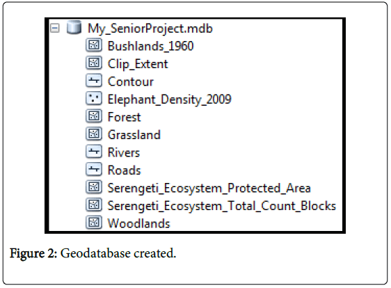
A file Geodatabase was created using the ArcCatalog of 10.1 it contained several vector layers consisting of shapefiles as polygon, polylines classed into, The features dataset with topology and geographic and projections are well defined. There others several dataset such as raster are imported to the Catalog in 10.1 Software, so it serves as a container that’s maintains, manages and handle different geospatial data formats effectively and in any efficient way it is a vital way of data handling and file management (Figure 2).
Data gathering and integration
The data to be gathered comprised of mostly primary data that were further manipulated and processed by various algorithms to generate different thematic maps these include roads, rivers, contours, woodlands, grasslands, forests all of them are vector data and will be all stored in the geodatabase, all the maps were converted raster data by using 30 m × 30 m grid cell size and georeferenced respectively to a common reference point in the (UTM) Zone 36S The land use and land cover was derived from the Landsat satellite data (Table 1).
| Projected Coordinate System | WGS_1984_UTM_Zone_36N |
|---|---|
| Projection | Transverse Mercator |
| False Easting | 500000.00000000 |
| False Northing | 0.00000000 |
| Central Meridian | 33.00000000 |
| Scale Factor | 0.99960000 |
| Latitude_of_Origin | 0.00000000 |
| Linear Unit | Meter |
| Geographical Coordinate System | GCS_WGS_1984 |
| Datum | D_WGS_1984 |
| Prime Meridian | Greenwich |
| Angular Unit | Degree |
Table 1: Spatial Reference of the data.
Data review
Detailed GIS data and high-resolution aerial photography had obtained with most accurate and current data available to provide the most accurate results. This imagery had been obtained from a free photogrammetric vendor high resolution satellite images (Landsat). They were in the raster format (note: they are in UTM projections 36S, so my shape files were projected to UTM as well. From these data, additional data were derived using queried analysis, GIS spatial analysis, and air photography interpretation. Additionally GPS field data collections were performed to gain additional specific data needed for the analysis.
Geographic objects
The basic geographic objects that we use are points, lines and polylines.
Polygons every kind of object is modeled by an abstract data type. We use the vectorial geometry to represent the geographic objects. This kind of modeling matches the representation used by the user interface. The geometry used in the interface and in the database is based on standard geographic data. The database and the interface shall be used in the context of an interoperability GIS. In Table 1 above are the GIS Data and Common Sources.
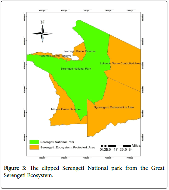
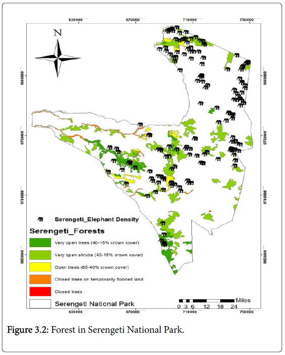
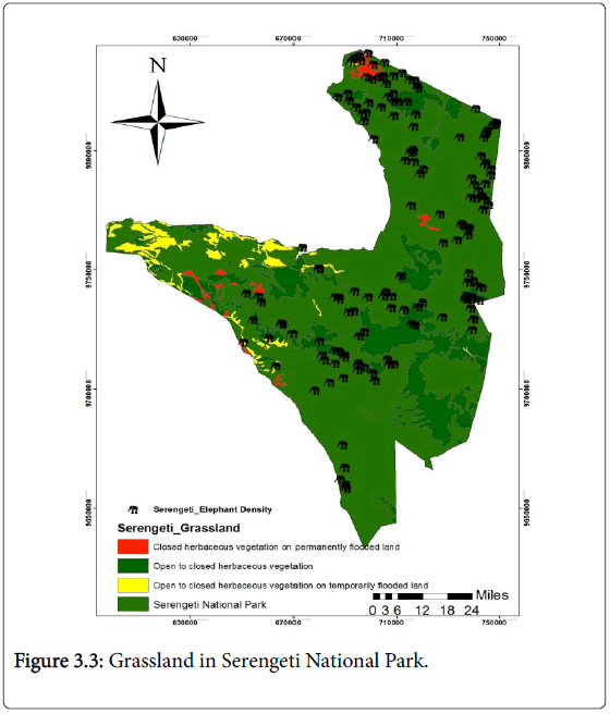
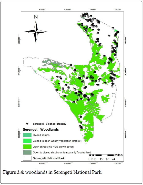
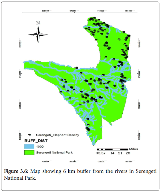
The produced documents (maps and graphs) are as flows in figures illustrated in sequence one after another (Figure 3).
AHP weights for wildlife habitat suitability analysis
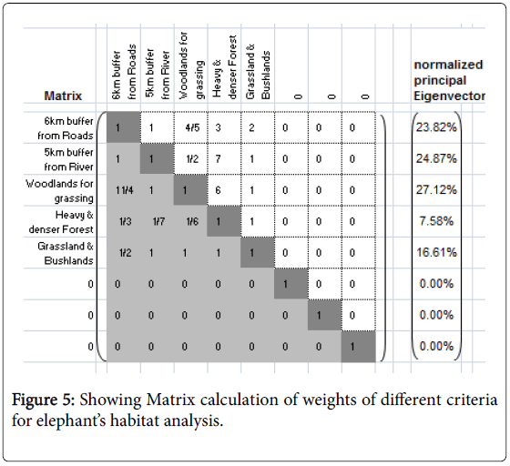
Used evaluation Analytical Hierarchy Procedure (AHP) the factors were each assigned weights based on a multi-criterion evaluation Analytical Hierarchy Procedure [8]. The AHP uses a nine point measurement scale 1 – Equal importance, 3 – Moderate importance, 5 – Strong importance, 7 – Very strong importance, 9 – Extreme importance.
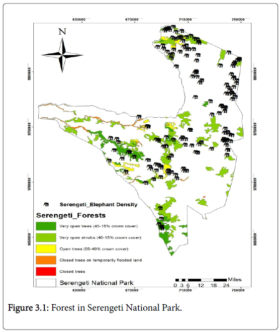
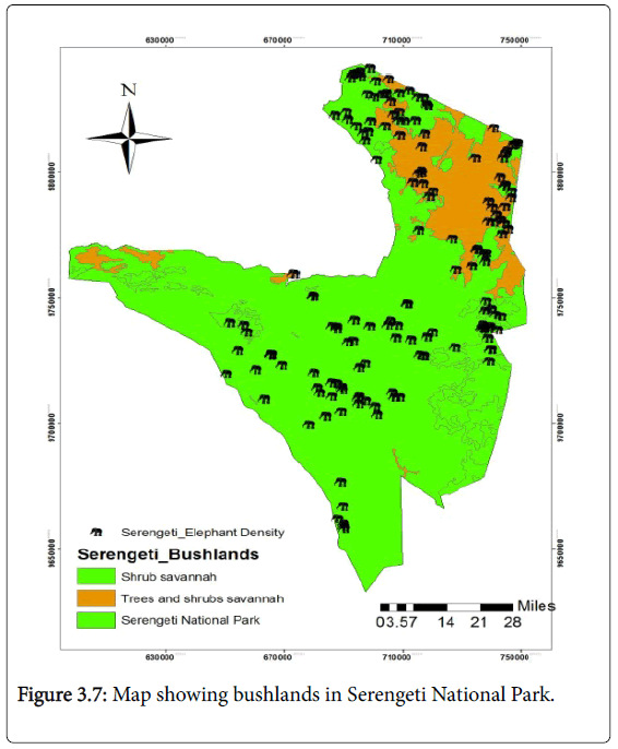
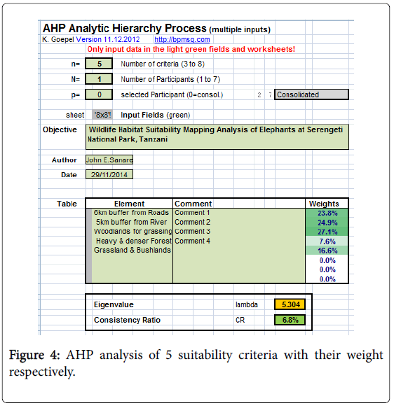
The other values of 2, 4, 6, and 8 constitute intermediate values between two adjacent judgments (Figures 3.1-3.7). This AHP is based on the assumption that some factors area more important than others are in a particular circumstance as illustrated in Figure 4.
Then Input set factors in the raster format each input raster is multiplied with a corresponding factor weight and then summed. The weights obtained from the AHP where to be used in weight overlay and weighty sum in ArcMap 10.1 to generate final suitability maps which will be divided into four natural classes of suitability level. For Elephant at the Serengeti national park, the habitat requirements of the Elephants and the variables related to these requirements were established based on the existing information available on this elephants, especially with reference to the study area. Five major factors were identified as being the most important in determining the suitability of an elephant.
To examine the rationality of AHP, it is necessary to determine the degree of consistency that has been used in developing the judgments. In AHP, an index of consistency, known as the consistency ratio (CR), is used to indicate the probability that the matrix judgments were randomly generated.
CR = CI/RI ……………………. 1
Where RI is the average of the resulting consistency index depending on the order of the matrix given by Saaty and consistency index (CI) is defined as:
CI = (λmax-n)/ n – 1………… 2
Where λmax-n is a principal Eigen value also referred as lambda and N is the number of our input criteria participated.
The advantage of this approach is to hypothetical random weight assignment is that there is some rule of thumb (consistency ratio <10) or else the user is forced to iterate the pairwise comparison until such rule is satisfied the weight overlay methodology of ArcGIS 10.1 (Figure 5).
Scenario: 1
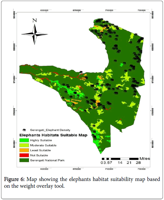
In our first Scenario we converted all of our five layers into raster and combine by using weight overlays tool in ArcMap 10.1 software with equal weights which a based on the distribution of each class of habitat factors to generate in thematic map for elephants habitat. Finally the thematic map overlaid Habitat analysis showed open tress at least (65-40%) crown cover to forest was the most important habitat factor considered elephant in habitat analysis, The forest factor needed to protect body, reproduction area and feeding elephant could not stay long term in open area, they needed close forest for protection, resting and sleeping.
Suitability habitat using habitat analysis concept using Geographic Information System (GIS) Arcmap 10.1 software technique by 5 illustrated in Figure 6.
Scenario: 2
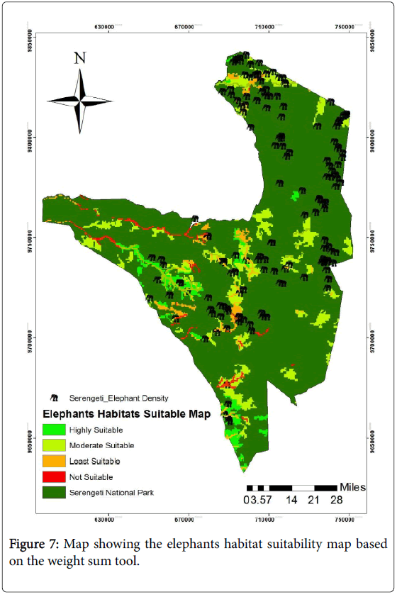
In the second Scenario, input set factors in the raster format were run using weighted sum approach. In this module each input raster is multiplied with a corresponding factor weight and then summed to arrive at a final suitability map in 5 classes. The weights used here were derived from the AHP procedure explained earlier. The output generated was then divided into three natural classes of suitability to obtain the final suitability maps. We used weighted sum tool because it accounting only for the individual weight of the layers. By using the AHP weights based on the assumption that some factors area more important than others are in a particular circumstance. Then Input set factors in the raster format were run using weighted sum approach in Arcmap 10.1 software. In this module each input raster is multiplied with a corresponding factor weight and then summed to arrive at a final suitability map in 5 classes. The weights used here were derived from the AHP procedure; the output generated was then divided into four natural classes of suitability to obtain the final suitability maps as shown and illustrated in Figure 7.
Comparative analysis of scenarios 1 and 2
The comparison of the all Scenarios are performed and the results showed that’s scenario one to be highly suitable, since about 116.73 km2 Area are highly suitable for elephants habitat and only 24.75 km2 are not suitable while in Scenario two the highly suitable area comprise of about 90.00 km2 and the not suitable area is about 27.00 km2 compared to that’s in scenario one. Based on the habitat factors, it identified five habitat factors preferred by elephants for their habitats showed distance to forest was the most important habitat factor considered elephant’s suitable habitat. The forest factor needed to protect body, escape, reproduction area and social interaction. Forest reserved suitable space and resource in tropical rain forest, elephant Suitability habitat was based on the dominance of faeces distribution of each class of habitat factor. Each habitat factors built in thematic map and its scoring. Finally the thematic map overlaid getting suitability habitat for elephants. It found that elephants not stay long term in open area; they needed close forest for protection, resting and sleeping Suitability habitat using habitat evaluation concept using Geographic Information System (GIS) technique conducted and it showed Based on the dominance of faeces distribution of each class of habitat factor each habitat factors built in thematic map and scoring. Finally the thematic map overlaid getting suitability habitat, The suitable habitat recommended Serengeti National Park habitat Suitability habitat found 862.5 ha (21.82%) good for elephant habitats. this area reserved suitable space and resource for elephant ecologically and biologically in primary forest Suitable habitat needed elephant and use more time than unsuitable habitat.
Conclusions
We have attempted the methodology of implementing five important factors for wildlife habitats suitability at Serengeti national park such as roads, river, bush lands, grasslands, woodlands and forests. The study demonstrated that’s GIS are helpfully in identification, assessments, and mapping the suitable habitats for elephants by combines decision support methodology with powerful visualization and analysing capabilities, which should considerably facilitate finding best suitable habitats for the elephants at Serengeti National park in Tanzania and this process improves the decisionmaking in natural resources management and innovations since Serengeti National park is the largest National park in Tanzania and the main national Icon and it requires to be more accurately protected from potential disappearance of this precious species such as elephant’s threats.
The implementation of the methodology described in this paper proven successfully in determining the suitable areas for the elephants at Serengeti Park.
From the results of the case study the following concluded
• Integrating the AHP and weight overlay analysis techniques for multi-criteria evaluation was very successfully and promising
• The Northern part of Serengeti national park was found to have a large area extent area with a more suitable for elephants since due to existing of the heavy forest , high grasslands and woodlands which highly suitable for the elephants for grassing, sleeping, socializing and reproduction also it’s a part of the park which is less affected by deforestation
• The central part of Serengeti national park was also found to be highly suitable due to the large presence of water bodies such as rivers and small which supply the sufficiency’s water for elephants drinking’s
• The potential use of GIS, Remote sensing and AHP were conclusive and very important technology tools for spatial decision support to display thematic decision suitable maps of various multi-factors for the elephants habitats
Recommendations
Considerable revising the whole thesis paper it is recommended the following:
• The elephant’s habitats suitability maps should be used by the agents, decision makers, wildlife management’s agency and other related organization of interest to aid in wildlife conservation and programmers awareness
• The results shows that forests, grasslands, bush lands and woodlands are under constant pressure and threats, therefore, it is highly recommended to monitor and manage this landscape in well manner and proper ways
• The current situation of the elephants at Serengeti National park is under a high threats therefore its recommended that the further research should be carried out by considering more factors and more techniques for the properly conserving these species
• Strengthen local community about benefits of planning, managing and conserving the wildlife with the implementation of the wildlife strategies and good policies
• To conduct the training for the staff in Serengeti National park on how to consolidate and update the important data for the wildlife in the park
• A follow up study that will check the limitation on the limitations of this study and make the field visit to validate and make verification of the results obtained in this case study
• Conducting further research and studies on elephant’s movements and distributions at Serengeti national park using web-based GIS for emergency and response and quick patrol
References
- Kainsz W (2005) Geographic information’s sciences (GIS).
- Palikhe A (20012) Use of GIS for Predicting Possible Animal Habitat.
- Brooks RP (1997) Improving habitat suitability index models 27: 163-167.
- TANAPA (2012) Wildlife Report, Tanzania National Park.
- ESRI (2010) GIS for wildlife Managements.
- Clark JD, Dunn JE, Smith KG (1993) A multivariate model of female black bear habitat use for a Geographic Information System 57: 519-526.
- Davis LS, DeLain LI (1986) Linking wildlife-habitat analysis to forest planning with ECOSYM 361-369.
- Goepel K (2012) Analytical Hierarchy ProcedureAHP weights for wildlife habitat suitability analysis.
Relevant Topics
- Aquatic Ecosystems
- Biodiversity
- Conservation Biology
- Coral Reef Ecology
- Distribution Aggregation
- Ecology and Migration of Animal
- Ecosystem Service
- Ecosystem-Level Measuring
- Endangered Species
- Environmental Tourism
- Forest Biome
- Lake Circulation
- Leaf Morphology
- Marine Conservation
- Marine Ecosystems
- Phytoplankton Abundance
- Population Dyanamics
- Semiarid Ecosystem Soil Properties
- Spatial Distribution
- Species Composition
- Species Rarity
- Sustainability Dynamics
- Sustainable Forest Management
- Tropical Aquaculture
- Tropical Ecosystems
Recommended Journals
Article Tools
Article Usage
- Total views: 16469
- [From(publication date):
December-2015 - Apr 04, 2025] - Breakdown by view type
- HTML page views : 14906
- PDF downloads : 1563

