Research Article Open Access
The Impact of Wind Stress in Modeling of Oil Pollution Diffusion in the Persian Gulf
| Omid Hajrasouliha1* and Smaeyl Hassanzadeh2 | |
| 1Department of Physics, Faculty of Sciences, University of Hormozgan, Bandar Abbas, Iran | |
| 2Department of Physics, Faculty of Sciences, University of Isfahan, Isfahan, Iran | |
| Corresponding Author : | Omid Hajrasouliha Department of Physics Faculty of Sciences University of Hormozgan Bandar Abbas, Iran Tel: +98 76 1335 0690; E-mail: omid_hajrasouliha@yahoo.com |
| Received October 31, 2014; Accepted February 24, 2015; Published February 27, 2015 | |
| Citation: Hajrasouliha O, Hassanzadeh S (2015) The Impact of Wind Stress in Modeling of Oil Pollution Diffusion in the Persian Gulf. J Bioremed Biodeg 6:282. doi:10.4172/2155-6199.1000282 | |
| Copyright: © 2015 Hajrasouliha O, et al. This is an open-a ccess article distributed under the terms of the Creative Commons Attribution License, which permits unrestricted use, distribution, and reproduction in any medium, provided the original author and source are credited. | |
| Related article at |
|
Visit for more related articles at Journal of Bioremediation & Biodegradation
Abstract
An oil pollution is the release of a liquid petroleum hydrocarbon into the marine environment due to human activity such as releases of crude oil from tankers, offshore platforms, drilling rigs and piping. The purpose of this study is to use a three dimensional hydrodynamic multi-purpose model coupled with biological and contaminant modules, in order to simulate the transport and diffusion of oil pollutions. After adjusting the model for the Persian Gulf region, the model was run to reach the steady state. The distribution of oil pollution in the different layers was predicted for different months of the year. The results show that the diffusion of oil pollution in the Persian Gulf is more affected by wind driven currents. The model also indicates that the wind stress is one of the major factors in the transport of contaminant and diffusion in the Persian Gulf and this factor leads to diffuse the contaminant concentration towards the north of the Gulf and then with a northern anticlockwise current pushing them towards the south. The results of this numerical simulation can be used in providing appropriate solutions to prevent oil from spreading further in the region.
| Keywords |
| Oil pollution; Wind stress; Coherens; Persian gulf; Numerical simulation |
| Introduction |
| The Persian Gulf, in southwest Asia, is an extension of the Indian Ocean located between Iran and the Arabian Peninsula. The Persian Gulf is located between 24° to 30°30’N latitude and 47° to 56°25’E longitude, according to the report of Persian Gulf Studies Center in 2008; Persian Gulf with an area of 237473 km squares (measured by Hydrographic Office of Iranian Geographic Organization, 2007) is the third largest gulf of the world after Mexico and Hudson Gulfs. The Persian Gulf was the focus of the 1980-1988 Iran-Iraq War. The Strait of Hormuz is a narrow waterway between the gulf of Oman and the Persian gulf and has 54 km wide in the narrowest place of its. Most of the produced oil is transported by means of oil tankers with an annual estimate of 35,000 tankers crossing the Strait of Hormuz [1]. It is considered one of the most strategic strait of water on the planet. Through its waters, in giant ocean-going tankers, passes much of the oil from Bahrain, Iran, Iraq, Kuwait, Qatar, Saudi Arabia and the United Arab Emirates. Bordered by Iran, Oman's Musandam Peninsula and the United Arab Emirates, this stretch of water is of obvious military significance, The Persian Gulf and its coastal areas are the world's largest single source of crude oil and related industries dominate the region. According to the report of U.S. Energy Information Administration (EIA) in 2002, the Persian Gulf nations of Iran, Bahrain, Iraq, Kuwait, Qatar, Saudi Arabia, and the UAE, produced about 25 percent of the world's oil, held nearly two-thirds of the world's crude oil reserves (Figure 1). An oil spill is a release of a liquid hydrocarbon into the environment, and is a form of pollution. A significant amount of oil is spilled into the sea from operational discharges, collision and grounding of tankers, well blowouts and pipeline-breaks.As mentioned. Oil is the most important source of pollutions in seas, about 90 percent of oil pollutions in seas is due to human activities, such as tankers traffic, drilling, piping and other. Because of the importance of oil transportation in the Persian Gulf, possibility of pollutant diffusion in this region exists from various ways. An oil spill accident can cause serious problems to the ocean environment through its contamination. Therefore, a real-time prediction of oil spill transport is very essential for clean-up operations and to estimate the effect of physical processes such as wind, tide and heat fluxes on pollutant transport. The use of numerical modeling in oil spill incidents is a well-established technique that has proven to provide cost-effective and reasonable estimates of oil surface drift [2]. As for the other pollutants, oil is subject to advection and diffusion, as it is less dense than water, much of the oil travels in a surface slick, which is affected by wind, waves and the surface current in the water [3]. In this study we want to simulate this movement and found the influence of wind stress on it, by a three-dimension hydrodynamic model that named coherens (Coupled Hydrodynamical Ecological Model for Regional Shelf Seas).. That sure, the result, after analyzed, will noteworthy help us to protect the marine environment and do preventive actions in this field. |
| Numerical Model |
COHERENS is a 3-D hydrodynamic multi-purpose model for shelf and costal seas that coupled to contaminant, biological and resuspension models. The program was developed over the period 1990-1998 by a multinational European group. It has primarily been used to simulate conditions in the North Sea and stratified coastal areas [4]. The user has the choice of several updated advection schemes for momentum and scalars. The model is based on the Boussinesq approximation and vertical hydrostatic equilibrium. We can solve these equations in both Cartesian  and spherical and spherical  coordinates, but in vertical direction 3 x convert to sigma. coordinates, but in vertical direction 3 x convert to sigma. |
| Mathematical model |
| The primitive equations of continuity, horizontal momentum and hydrostatic equilibrium for the three-dimensional mode in the sigma coordinate are as follows [4]. |
| Equation for continuity: |
 (1) (1) |
| Equation for horizontal momentum: |
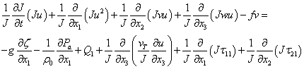 (2) (2) |
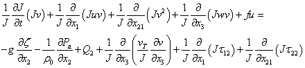 (3) (3) |
| Equation for hydrostatic equilibrium: |
 (4) (4) |
| Equation for temperature and salinity: |
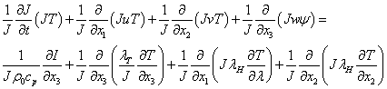 (5) (5) |
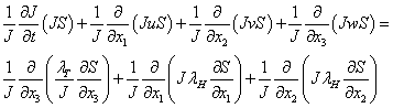 (6) (6) |
where  represents the ratio of a unit length in the physical to a unit length in the transformed space; u,v,w are the components of velocity in the x, y and z directions; f is the Coriolis frequency; represents the ratio of a unit length in the physical to a unit length in the transformed space; u,v,w are the components of velocity in the x, y and z directions; f is the Coriolis frequency;  is the reference density; is the reference density;  denote the diffusion coefficients and vertical eddy viscosity, respectively; T and S are the temperature and salinity; denote the diffusion coefficients and vertical eddy viscosity, respectively; T and S are the temperature and salinity; is the horizontal diffusion coefficient for salinity and temperature; is the horizontal diffusion coefficient for salinity and temperature;  is the atmospheric pressure; is the atmospheric pressure;  are the components of the baroclinic pressure gradient; g is the gravity acceleration; are the components of the baroclinic pressure gradient; g is the gravity acceleration;  is the specific heat of seawater; I is the solar irradiance; qd is the baroclinic pressure and b is the buoyancy. is the specific heat of seawater; I is the solar irradiance; qd is the baroclinic pressure and b is the buoyancy. |
| The horizontal components of the stress tensor are defined as follows [5]. |
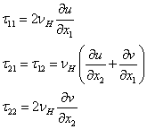 (7) (7) |
| Where vH is the horizontal diffusion coefficient for momentum. Then the program solves a series of transport equations as follows for a given number of contaminant distributions [4]. |
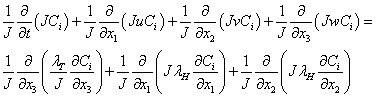 (8) (8) |
That  ,and initial distribution are specified by the user. ,and initial distribution are specified by the user. |
| Model setting and configuration |
| The numerical model calculates in Cartesian coordinates, with the vertical axis representing sigma coordinates, the horizontal axis representing Arakawa C grid. The model uses the total variation diminishing (TVD) scheme for the advection item of momentum and scalar. We use this scheme to avoid numerical dissipation caused by the upwind scheme and false direct transport brought about by the laxwandroff scheme and to improve the calculation accuracy. The model is initialized in December (because of seawater is well mixed in winter), using uniform temperature and salinity fields with values of 19°C and 38psu . The model was run with an external mode time step of 60 s and an internal mode time step of 5 min, which satisfies the CFL condition. The hydrodynamic section of model uses solving initial equations of momentum, continuity and temperature and salinity. The calculation is based on the ‘‘ k –ε ” turbulence closure scheme, which is used after considering the turbulent kinetic energy k and dissipation rate ε to obtain the vertical eddy viscosity coefficients for momentum and λT for vertical eddy diffusion coefficient for temperature and salinity. The turbulence energy k is obtained by solving a transport equation and the dissipation rate ε is computed from |
 (9) (9) |
| Where ε ° is a constant coefficient and l is the mixing length, that obtained algebraically using ‘‘quasi-parabolic” law. The horizontal diffusion coefficient is determined using the proportional relationship with the horizontal grid spacing and the magnitude of the velocity deformation tensor. |
| The model domain includes Persian Gulf with one open boundary in the gulf of Oman, covering the area of 47 ° - 58 ° E; 24 ° - 31 ° N, Five sigma layers are used in the vertical direction [6]. |
| As the input data, the meteorological parameters (wind components at 10 meter above ground, air temperature relative humidity, cloud cover and precipitation) are needed. All these data were derived from the National Oceanic and Atmospheric Administration (NOAA). The model Includes realistic topography; it is forced by the surface wind stress, heat fluxes and tide, that tidal harmonic constants of the four tidal components (K1, O1, M2, and S2) are specified. The model was run for 5 years to reaching the steady state, and then set the initial concentration for corresponding grid pollutions for the release location shown in Figure 2. This is located at longitude of 50°E and latitude of 29°32′N ; near the Nowruz oil field, that in this region, the potential of oil spill is higher than other parts of gulf because of existence much oil field (Figure 3). The type of oil that spills, is crude oil of Iran, which product in National Iranian Oil Company, and has the density between 0.8 to 0.9 kg / l at 20°C and the viscosity less than 12 CST, with accidental spill of 1500 tons of it that has about 4 km radius. Then run the model with this contaminant for one year to predict the distribution of oil pollutions in various months. Then to find out the influence of wind stress in oil pollution diffusion, at first run the model with all these forces (wind, heat flux, and tide) with setting of the numerical calculation area and hydrodynamic parameters that are same as above, then run the model with not considering wind stress as a force and then the difference between tow run indicate the effect of wind stress on oil pollution transport and diffusion in the Persian gulf region. |
| Results |
| The model was run under the initial and boundary conditions. In this part we discuss in result of numerical simulation of oil pollution diffusion and the impact of wind stress on it. As we said, at first the model run with consider all physical processes that effect on pollutant transport, such as; wind, heat fluxes and tidal forcing, and named it run1, then model run with no taken account of wind stress components and named it run2, but It should be noted that in this run for calculating the latent and sensible fluxes the wind speed is considered. The most well-known, and notorious, weather phenomenon in the Gulf is the shamal; a northwestern wind which occurs year round and in winter brings some of the strongest winds [7]. The time series of contaminant concentration for surface layer, middle layer and bottom layer are given in Figure 4. The contaminant concentration in three layers, particular during winter (Dec-Feb) has a noticeable decrease in concentration due to surface wind stress and mixing with water. The contaminant concentration also decreases from surface layer to bottom layer as shown in Figure 4. The current induced by the wind is strong at the surface, but this current decrease quickly with depth [8]. Winds transport oil spills through the combined action of wind-generated currents, Wind-induced waves and direct wind shear. The effects of wind and current on a surface spill act independently and can therefore be described as a vector sum of velocities. The wind-induced oil spill speed is a small fraction of the wind speed. Moreover, the direction of the oil spill motion is at a non-zero angle to the direction of the wind due to Coriolis forces [9]. Figure 5 shows time series of contaminant concentration with remove of wind stress from initial forces, in three layer of ocean. As seen the contaminant concentration increase in compare with Figure 4, which indicates the influence of wind stress on concentration. |
| Wind stress |
| The wind stress is the shear stress exerted by the wind on the surface of large bodies of water such as oceans or seas, Put another way, it is the vertical transfer of horizontal momentum. Thus momentum is transferred from the atmosphere to the ocean by wind stress and it calculated from |
 (10) (10) |
Where 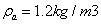 is the density of air, U10 is wind speed at 10 meters above the water surface, D C is a dimensionless quantity winddrag coefficient that measured using the wind fluctuations within 10- 20 meter of the sea surface, from which τ is directly calculated. The correlation of τ with is the density of air, U10 is wind speed at 10 meters above the water surface, D C is a dimensionless quantity winddrag coefficient that measured using the wind fluctuations within 10- 20 meter of the sea surface, from which τ is directly calculated. The correlation of τ with  gives D C . We should remove both surface stress component in X-direction and Y-direction that normalized by ρa , in run 2 gives D C . We should remove both surface stress component in X-direction and Y-direction that normalized by ρa , in run 2 |
| Then difference between tow run indicates the impact of wind stress on oil pollution transport. Figure 6 shows the comparison between the time series of surface contaminant concentration with and without effect of the wind stress. As shown the wind stresses cause to decrease in initial concentration in the first month after release. |
| Discussion |
| Special event induced by strong wind such as storm surge or others and extreme sea events are outside of our research or not occur, so we just take the normal wind stress into consideration. Figure 7 shows the simulation results of the pollution of releases for different months. The contaminant difference (Run 1 minus Run 2), represents with increasing contaminant concentration ( Δ CONCN >0) or decreasing ( Δ ΔCONCN <0) effect of the wind stress (Figure 7). In the first three months after releasing (Dec-Feb), the components of wind stress pushes oil spill from initial position to the west and causes a major decrease in initial concentration because of stronger wind stress in this season and mixing with water, the wind speed is stronger in winter than that in summer [10]. In the second three months (Mar-May) the wind stress causes to increase in concentration in west and north and almost south part of the Persian Gulf and generates a northern anticlockwise circulation, which is in good agreement with Reynolds results [11]. In the third three months (Jun-Aug) the northern anticlockwise circulation is formed and leads to increase in concentration in north part along the Iranian coast, and decreases in the central part of the Persian Gulf. In last three months (Sep-Nov), as same as previous three months, wind stress causes to increase concentration in north part and decreases concentration much further towards the south and southeast of the Persian Gulf. As seen in Figure 7 the wind stress leads to transport and diffuse oil spill from initial position to the north of the Persian Gulf and increases the concentration of pollution in compare with other part in the area. |
| Time series of effect of wind stress on contaminant concentration at surface layer, middle layer and bottom layer are shown in Figure 8 and positive value of ΔCONCN shows the increase in concentration and the negative value shows decrease of concentration. At the surface layer one minimum occurs in March and indicates the decrease of concentration due to wind stress, and two maxima occur in late December and late Jun that show the increase of concentration at that point because of wind stress. In general, at the middle and bottom layer in most portions of the Gulf ΔCONCN value is positive for all months of the year with the maximum effect occurring in winter for bottom layer. |
| Conclusion |
| Real-time prediction of wind stress-induced transport of an oil pollution floating on the sea surface was obtained. The prediction was based on the result of model simulations in the Persian Gulf region, one technique was proposed for understanding the influence of wind stress on oil pollution transport and diffusion, which was the difference between two runs of the model. In the first run (run 1) all effective physical processes, such as; wind, heat fluxes, tidal forces and other on oil pollutions transport and diffusion were considered and then run the model, but in the second one (run 2) the effect of wind stress on the surface was removed, but other parameters are used the same as previous run. The model output indicated that the wind stress causes, transportation and diffusion of the oil spill toward the north and then by forming a northern anticlockwise current, they are pushed to the south of the Persian Gulf. The point should be noticed is that the numerical simulation with a 3-d hydrodynamic model such as coherens is very useful to investigate the influence of the physical processes on the transport and diffusion of oil pollutions. However, the result of simulation will need to be validated against observations in the future but now, because of lack of such observations in the Persian Gulf, we cannot validate result with them and suggest working on it in the future. |
References
|
Figures at a glance
 |
 |
 |
 |
| Figure 1 | Figure 2 | Figure 3 | Figure 4 |
 |
 |
 |
 |
| Figure 5 | Figure 6 | Figure 7 | Figure 8 |
Relevant Topics
- Anaerobic Biodegradation
- Biodegradable Balloons
- Biodegradable Confetti
- Biodegradable Diapers
- Biodegradable Plastics
- Biodegradable Sunscreen
- Biodegradation
- Bioremediation Bacteria
- Bioremediation Oil Spills
- Bioremediation Plants
- Bioremediation Products
- Ex Situ Bioremediation
- Heavy Metal Bioremediation
- In Situ Bioremediation
- Mycoremediation
- Non Biodegradable
- Phytoremediation
- Sewage Water Treatment
- Soil Bioremediation
- Types of Upwelling
- Waste Degredation
- Xenobiotics
Recommended Journals
Article Tools
Article Usage
- Total views: 14613
- [From(publication date):
March-2015 - Jul 06, 2025] - Breakdown by view type
- HTML page views : 9935
- PDF downloads : 4678