Technological Interventions in Delineation of Palaeochannels for Groundwater Development in Sangrur District in Punjab
Received: 25-Jan-2018 / Accepted Date: 26-Mar-2018 / Published Date: 30-Mar-2018 DOI: 10.4172/2157-7617.1000459
Abstract
Indo-Gangetic plains are categorized as over stressed due to intense agricultural practices specifically dependent on ground water extraction. The exploitation of all resources in general and groundwater resources in particular are posing a serious threat to sustenance of flora and fauna. In the present study an effort has been made to demarcate the palaeochannels of Sangrur district, Punjab (29 40’ and 30 38’N, 75 16’and 76 10’E) with the help of sophisticated tools like GIS and satellite remote sensing which provides synoptic, multi-spectral and multi-temporal coverage. Neotectonic movements in the Late Quaternary lead to change in the direction of the flow of various drainage systems. The migration and later on abandonment of these drainage systems have given rise to number of dry Palaeochannels which are seen as great potential source of groundwater in the study area where groundwater levels are steeply declining. Inference of drilling data proposes that vertical thickness of palaeochannels ranges between 70 to 140 meters, constituted of alternating layers of fine to medium sands with occasional gravels. Groundwater quality along these palaeochannels are of good quality hence makes it a future target area for groundwater exploitation. Technological interventions are need of the hour to develop our resources on sustainable approach as it will help us to demarcate and quantify these resources for sustainable development and this study is an attempt in this direction.
Keywords: Neotectonic; Quaternary; Drainage; Groundwater; Palaeochannels; GIS; Remote sensing
Introduction
Palaeochannels belong to past riverine environment and are the remnants of old streams, rivers which were flowing either ephemeral or perennial during the past and now stand, either buried or lost and shifted due to tectonic, geomorphic as well as anthropogenic activities and climatic vicissitudes [1]. There are many mythological, archeological, geomorphological, geophysical and remote sensing evidences which point towards the presence of well-integrated drainage network in the alluvial plains of Punjab, Haryana and Thar Desert in Rajasthan [2]. Various workers have delineated palaeo drainage courses using aerial photographs and landsat imagery [2,3]. According to their views, upliftment of Himalayas and Siwaliks, upliftment of the Aravallis, climatic changes and changes in glaciations in Himalayas are the main reason responsible for drainage desiccation in the NW region and drying up of Saraswati.
A number of workers have mapped the palaeochannels of different areas and presented various views based on their studies. Based on the observation of satellite images which were used to map the palaeochannels of the river Saraswati in north west India [4], believed that there has been an upliftment of the region along Aravalli hills, which has resulted in the west-ward shift of the streams located in the western side of the Aravalli Hills (like river Satlej) and the eastward shift in streams located in the eastern side of the Aravalli Hills (Like river Yamuna/Chambal). Bakliwal and Ramasamy have similar views [5]. Using Landsat satellite RS data Yashpal et al. [6] provided detailed sketch of the Palaeochannels of Satlej, Yamuna and Ghaggar, etc.,
The present day geomorphic features in the Indo-Gangetic plains are the result of the climatic fluctuations and fluvial adjustments during late Pleistocene-Holocene period, with a subdued role of tectonics of Himalayas [7]. The palaeochannels considered as lost drainage are still having under flow of ground water evidenced by abnormally high pumpage discharge, fresh to low saline quality in comparison to water occurring in adjoining non-riverine environment and are also comparatively older in character [8]. Such palaeochannels are being looked upon as possible reservoir of ground water [9]. Apart from being good source of potable water, they are also good recharge zones of aquifers. Palaeochannels make the low-lying part of the alluvial plain in the area; retain good moisture during precipitation and floods. This makes them excellent and rich source of ground water [10-15].
In the present study an effort has been made to demarcate the palaeochannels with the help of sophisticated tools like GIS and satellite remote sensing which provides synoptic and multi-spectral and multitemporal coverage. GIS is helpful in generation of permanent digital data base. The fence diagrams and lithologs provide ample information about the aquifer thickness and nature of the aquifer material beneath the palaeochannels.
With increased dependence on groundwater for continuous irrigation to paddy crops, the water levels are declining rapidly with every growing season. In this context, the specific objective of the study was to delineate paleochannels for ground water evaluation potential based on the water quality and decline of the sub-surface water levels through technology interventions. The present study aims towards the demarcation of paleochannels for sustainable hydropotential through artificial recharge regimes of the study area.
Study area
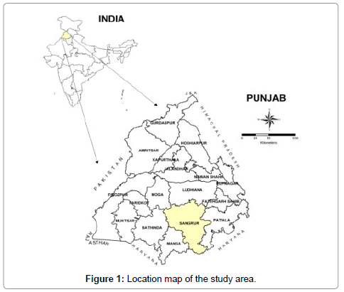
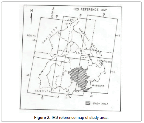
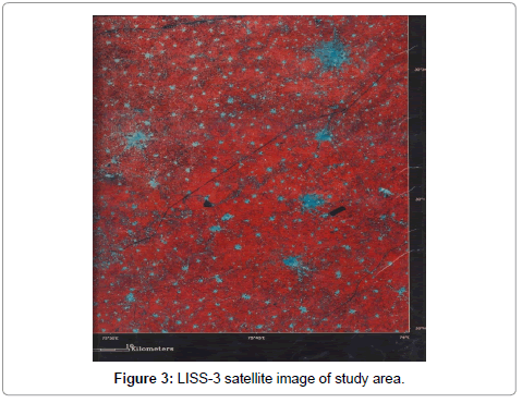
The Sangrur district encompasses an area of about 5107 sq. kilometers and lies between North Latitude 29° 40´ and 30° 38´, East Longitude 75° 16´ and 76° 10´.The area falls in the survey of India toposheets No. 44N, 44O, 53B and a little area in 53C (Figures 1 and 2). Administratively the Sangrur District is divided in twelve community blocks namely, Andana, Ahmadgarh, Barnala, Bhawanigarh, Dhuri, Lehragaga, Mahalkalan, Malerkotla, Sangrur, Sehana, Sunam and Sherpur (Figure 3). The study area is bordered by Ludhiana district in north, Patiala district in east, Bathinda district in west, Haryana state in the south, Fatehgarh Sahib District in northeast, Moga district in northwest and Mansa district in southwest.
Materials and Methods
The study was conducted using IRS-1C, LISS-III in the form of false colour composites (FCC) generated on band 2, 3 and 4 on 1: 250,000 scales for the year 2000. The methods used in the present study are detailed below:
Demarcation of palaeochannel using remote sensing and GIS
The IRS-1C, LISS-III data in the form of false colour composites (FCC) generated on band 2, 3, and 4 on 1: 2,50,000 scales for the year 2000 were visually interpreted (Table 1). Palaeochannels in the study area were extracted from the geomorphological map using arc-info software and were studied in detail (Figure 3 and Figure 4). The palaeochannels were delineated on the basis of the linear, curvilinear, meandering courses, channel like shape, high moisture, linear depression, vegetated regions and association with fluvial landforms. The already identified archaeological maps were superimposed on the palaeochannel maps to get an idea regarding the presence of palaeobanks based on the history of settlement of the early civilizations on the river banks. Near about 30 percent palaeochannel area was checked during field visit.
| Category | Area (Km2) | % of total geographical area |
|---|---|---|
| Alluvial Plains (AP) | 4080 | 86.90 |
| Basin | 38 | 0.80 |
| Palaeochannels (PC) | 515 | 11.00 |
| Sand Dunes | 63 | 1.30 |
| Total | 4696 | 100.00 |
Table 1: Showing various geomorphic units in the study area-Sangrur district in Punjab.
Water analysis
In order to assess the quality of the ground water in the palaeochannels a total of 29 water samples were collected from tube wells confined to different lithological units. The samples were collected from different places within the palaeochannels and are as Kanjhla, Ghanauri Kalan, Fatehgarh, Khurd, Chaunda, Mohurana, Bhasaur, Babanpur, Benra, Badrukhan, Hamidi, Dhaner, Dhanaula, Ubbewal, Longowal, Harditpura, Kalajhar, Bhutana, Bhainimeraj, Khudikalan, Chajjli, Balwar Khurd, Jhubriwalan, Kaudan, Moom, Bhogiwal and Tellewal. The geochemical analyses of water samples were carried out for various parameters (TDS, pH, CO3, HCO3, total hardness, Cl-, SO4, Ca2+, Mg2+, Na+, K+, NO3, SiO2, F) using standard methods from APHA (2000).
Sand and mineral analysis
The lithological columns were studied during on-site drilling at tube-well locations in the study area. The studying the composition of the sand samples collected from the palaeochannels sieve analysis was carried out while the mineral composition was studied with the help of magnetic separation.
Collection of archaeological samples
In the field some sites like Mard Kheda, Rohira, Bhasaur were visited for collection of arcaheological samples which were later studied for generating more information with the help of archaeological experts.
Results and Discussion
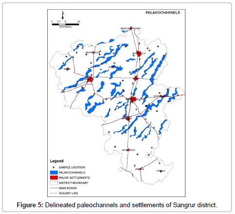
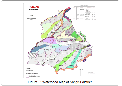
Palaeochannels cover an area of about 515 sqkm area in the alluvial plains of the study area. These channels follow the general trend of ground water flow and slope of the area i.e., NNE to SSW. Total numbers of palaeochannels identified from the satellite data are about thirtyone, only six channels show connectivity rest of the palaeochannels are discontinuous. The average length of the palaeochannels varies between 3 km to 45 km and average breadth of channels ranges between 0.3 km to 0.8 km. Superimposition of the village boundaries over palaeochannels shows they traverse through 314 villages of the Sangrur district. Existence of these palaeochannels has been confirmed on the basis of some indirect field evidences in the form of geomorphology, hydrology, subsurface lithology and archeology and paleontology which supports the finding of RS technology. Superimposition of the basin boundaries over the palaeochannel map shows that all the palaeochannels in the study area are the part of the Ghaggar River system, only two palaeochannels above this basin boundary belong to the Satlej river system (Figures 5 and 6).
Geomorphological evidences
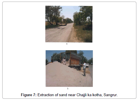
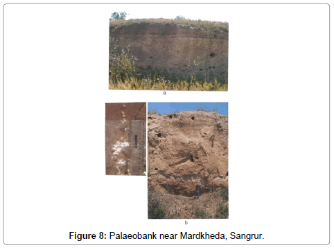
The high moisture, vegetated regions and their association with the fluvial landforms helps in delineating palaeochannels in the field. Presence of levees/ palaeobanks near Mardkheda and Chajjli ka kotha villages near Sunam shows signs of palaeochannel.Huge amount of aquifer sands are being mined from the same site which again supports the presence of palaeochannels in the area (Figures 7 and 8). These channels show both continuous and discontinuous pattern, trending in northeast and southwest directions. A closer view of the palaeochannels suggests gradual shift in their courses from south to southwest direction. Similar conclusions were made by Yashpal et al. and Sahai [5,6].
Hydrological evidences
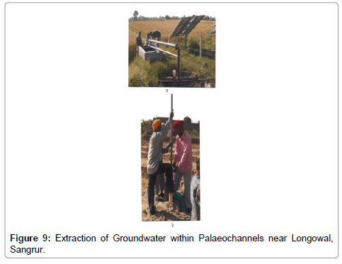
Palaeochannels are the low lying geomorphic units having high moisture. The subsurface lithology of the palaeochannels reveal thick granular zone which indicate good aquifers. The quality of the water is comparatively better than non-palaeochannel regions. During heavy precipitation or floods the palaeochannel region can withhold high amount of moisture or water compared to non palaeochannel areas. Over all palaeochannel shows promising source of potable water (Figure 9).
The results of the water analysis revealed that most of the water confined in palaeochannel area is NaHCO3 and mixed type. The quality of water within palaeochannels is potable and fit for irrigation as well as drinking purposes. No doubt, it holds much hope for future as huge untapped reservoir of fresh water resource.
Lithological evidences
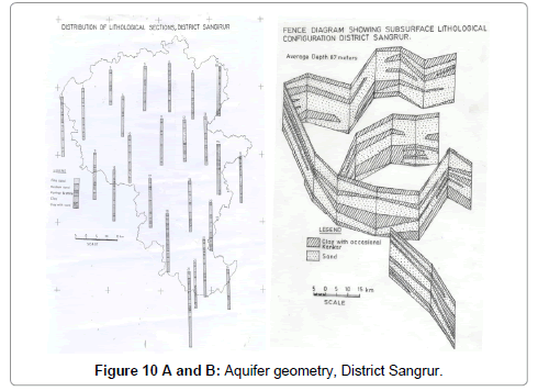
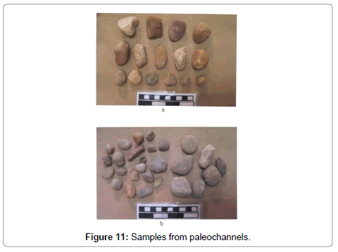
Subsurface lithology based on lithologs and fence diagram (Figures 10A and 10B) below the palaeochannels reveal high cumulative thickness of sands compared to non palaeochannel regions. These may prove potential aquifer with better yield compared to non-palaeochannels area. During on-spot drilling at tube well locations on palaeochannel regions yielded perfect rounded cobbles and pebbles of various sizes and colour in the lithological column. The presence of pebbles and gravels indicate the riverine environment and their roundness are attributed to the transportation of the material. Analysis of the sand from the aquifers of the different palaeochannels has revealed that they constitute quartz percentage which ranges from 76.86 to 82.41 percent and heavy minerals ranges from 1.29 to 2.05 percent (Table 2).
| S. No | Location | Sample wt. (mg) | Isodynamic separation Biotite ---- Silica + Clay |
Clay removal | Heavy Mineral | Qtz.% (Chem.) |
|---|---|---|---|---|---|---|
| 1 | Chajjli | 100 | 13.03 ---- 86.87 | 0.41 | 2.05 | 82.41 |
| 2 | Longowal | 100 | 16.16 ---- 83.14 | 1.58 | 1.89 | 79.67 |
| 3 | Longowal | 100 | 15.02 ---- 84.88 | 0.53 | 2.0 | 82.35 |
| 4 | Bhawanigarh | 100 | 20.21 ---- 78.89 | 0.74 | 1.29 | 76.86 |
| 5 | Dhanaula | 100 | 14.17 ---- 85.83 | 0.51 | 1.86 | 81.29 |
Table 2: Results of sieve analysis of aquifer material (sand) collected from palaeochannels (Values in grams).
Heavy minerals also give the account of the transportation of the material through the agency like streams and past rivers. These heavy minerals are probably transported from the source somewhere in the Himalaya. Presence of heavy minerals like hornblende, zircon, rutile, biotite and muscovite, has also been reported by Malik et al. [16]. Results of sieve analysis of the samples collected from palaeochannels are shown in Table 3.
| S. No. | Location | Mesh no.30 |
Mesh no. 40 |
Mesh no.50 | Mesh no. 70 | Mesh no. 100 | Pan |
|---|---|---|---|---|---|---|---|
| 1 | Chajjli | 0.60 | 0.77 | 2.64 | 11.99 | 55.57 | 27.70 |
| 2 | Longowal | 0.92 | 0.69 | 2.84 | 13.01 | 43.41 | 39.04 |
| 3 | Longowal | 0.66 | 1.82 | 20.25 | 31.81 | 29.50 | 15.37 |
| 4 | Bhawanigarh | 0.62 | 5.41 | 15.85 | 18.39 | 30.09 | 29.44 |
| 5 | Dhanaula | 0.68 | 0.64 | 2.40 | 14.90 | 41.06 | 40.80 |
Table 3: Isodynamic separation of various sand samples from palaeochannels.
From sieve analysis of the aquifer material it have been found that Dhanaula sample contains high percentage of fine grain sand/ silt while Longowal sample contains coarse grained sand. Moreover, the aquifers at Longowal and Bhawanigarh seem more productive as they contain high percentage of coarse grained sand compared to the aquifers of Chajjli and Dhanaula (Figure 11).
Archaeological evidences
The earliest settlement found in Sangrur is believed to have begun around 2,300 B.C. Attracted by the fertile soil and availability of water, people from Sind and Baluchistan started moving and following the path of the Satlej or the Ghagger and settled at Rohira. This period is designated as pre-Harappan. The findings at this place are comparable with those of Kalibangan (Rajasthan). Banawali (Bhiwani District), Balu (Jind District) and Kot Diji and Amri in Pakistan. Kalibangan in the Sri Ganganagar area of Rajasthan was the first site to reveal an important pre-Harappan settlement after 10 years of continuous excavation. Archaeological experts believe that from the Kalibangan area, pre- Harappan people started moving in the northern or north-eastern direction along some of the streams that have now dried up. Ranges of sand dunes mark the ancient water courses. The different stages of this movement towards the Satlej have remained uninvestigated so far.
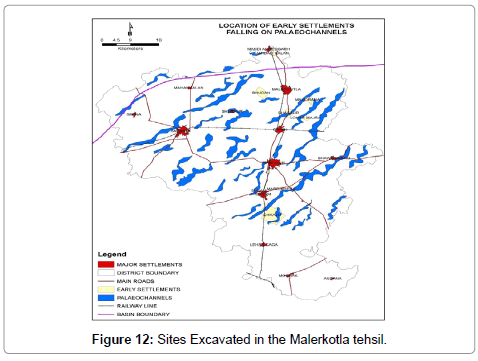
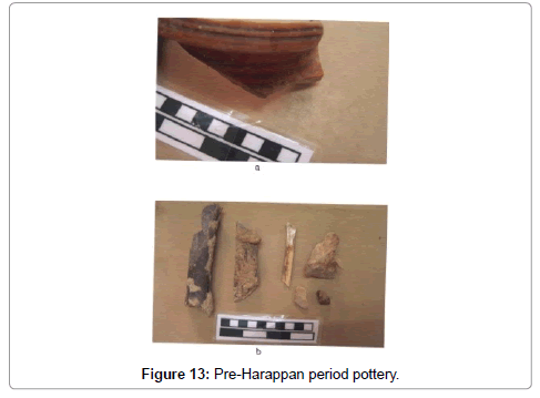
The important sites so far excavated in the Malerkotla tehsil are as Rohira, Mahorana, Bhudan, Bahwa, Bhasaur, Dhingri, Jandali, Theh Loharan and Mardkheda at Sunam (Figure 12). It is situated along the line of depression, which follows the ancient course of river Satlej. Recently, an exciting discovery of a pre-Harappan settlement which thought as pre-cursor of the Indus Valley of Harappan civilization has been made at an ancient mound at Ruhira which has now emerged as second important pre-Harappan site in. India. In the field some sites like Mard Kheda, Rohira, Bhasaur were visited and analyzed. The pottery of Pre-Harappan period was found intact and samples of pottery were collected from the site (Figure 13). The mound is about 3 meters high showing good signs of a river bank in the past near Mardkheda.
Palaeontological evidences
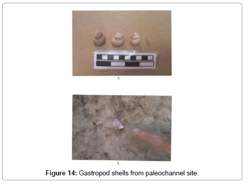
Palaeontological evidences can also verify the presence of palaeochannels in the field. In the Sunam block of the Sangrur district, some fresh water gastropods were collected from palaeochannel sites as shown in photographs. Fresh water gastropods generally thrive in fresh water bodies like lakes and riverine environment, besides this some animal bones were also found intact. These bones indicate some early settlement along a river side. The fresh water gastropod shells found at palaeochannel site were identified after comparing the shells with other known species of gastropods. These shells belong to Viviparous sp. These are also called as mud snails. Mud snails are herbivores; they eat plants from the bottom of water (Figure 14).
Shell is smooth with high spire and there are vertically oriented light gray coloured bands. Height of average shell is 3.2cm and width 2.3cm respectively. Whorls rounded and body whorl large and convex. Sutures are deeply impressed. Apex is pointed and circular in cross section. Aperture is hollow and entire with oval shape. These species are found in ponds but they are also found in shallow water lakes and canals, close to paddy fields.
Palaeochannels acting as conduites to flooding
Sangrur area forms the part of the vast alluvial plain of Punjab. All the river basins and the low lying alluvial plains suffer from the menace of flooding due to incessant rainfall and over spilling of the streams. Satellite remote sensing technology helps to provide prompt and accurate temporal information about the spatial extent of the floods. This technique gives information of the actual flood-inundated areas which is useful for the long-term planning A number of studies have been made in Punjab in flood disaster assessment [17].
Sangrur area has experienced floods twice in the recent past during year 1988 and 1993 respectively. Both the floods are well documented in the satellite imageries. The palaeochannel was super imposed with the help of GIS to establish a relationship between palaeochannel and flood prone area in Sangrur district. The relationship between palaeochannels and the flooded area can be ascertained with help of prepared flooded maps. Palaeochannels are the low-lying part of the alluvial plains of Sangrur area; hence they become instrumental in carrying the floodwaters due to incessant rains. Some other lowlying pars of the alluvial plains have also played role in bringing flashfloods. Human activities like agriculture practices, settlements, construction of roads and the most important drains and canals have changed the morphology of the natural drainage system of plains and palaeochannels. These changes have also added in the cause of floods. During monsoon seasons Ghaggar River causes localized flooding in the surrounding areas of Andana block.
The present study has revealed a great deal of information related to the palaeochannels. The IRS-1C, LISS-III data in the form false colour composites (FCC) generated on band 2, 3, and 4 on 1: 2,50,000 scales for the year 2000 were visually interpreted. The major geomorphic units identified in the Sangrur area are, alluvial plains, palaeochannels and sand dunes. The geomorphological units were delineated on 1: 2,50,000 scale base map prepared from the Survey of India topographical maps. The alluvial plain constitutes the largest geomorphic unit in the study area occupying about 87% of the total geographical area. Palaeochannels are the second largest geomorphic unit in the Sangrur area after the alluvial plain covering an area of 515 km2. Sand dunes occupy an area of about 63 sqkm. Palaeochannels in the study area were extracted from the hydrogeomorphological map and were studied in detail. The palaeochannels were delineated on the basis of the linear, curvilinear, meandering courses, channel like shape, high moisture, linear depression, vegetated regions, and association with fluvial landforms. The paleochannels follow the general gradient and slope of the study area which is from northeast to southwest. Superimposition of the basin boundaries over the palaeochannel map reveal that all the palaeochannels in the study area are the part of the Ghaggar river system; only two palaeochannels above this basin boundary belong to the Satlej river system. The average length of the palaeochannels varies in between 3 km to 45 km and average breadth of channels varies in between 0.3 km to 0.8 km. Superimposition of the village boundaries over palaeochannels reveals that palaeochannels traverse through 314 villages of the Sangrur district. Palaeochannels also hold good promise of being suitable sites for artificial recharge because of their granular nature of the aquifer material as revealed by the study of subsurface lithologs. Superimposition of the palaeochannel over the subsurface lithologs shows high cumulative thickness of sand layers underneath of palaeochannels. Analysis of the sand from the aquifers of the different palaeochannels has revealed that they constitute quartz ranging from 76.86 to 82.41 percent and heavy minerals ranges from 1.29 to 2.05 percent. Heavy minerals also give the account of the transportation of the material through the agency like streams and past rivers, these heavy minerals are probably transported from the source somewhere in the Himalayas. Sieve analysis shows that Longowal and Bhawanigarh have coarser material compared to Chajjli and Dhanaula.
The palaeochannels have been identified in the field using indirect field evidences like geomorphology, hydrology, lithology, Paleontology and archaeology. The palaeochannels are having better quality of ground water compared to the non palaeochannel region. Demarcation of palaeochannels in the Sangrur area can be further studied in relation to the ground water prospecting like artificial recharge etc. These studies hold good promises for sustainable ground water development in the study area.
Conclusion
The study has shown that tools like GIS and remote sensing can be effectively used in locating past river courses, can be helpful in locating buried freshwater resources in areas which are deficient and scarce in such resources. Moreover, these river courses can be effectively used as groundwater artificial recharge sites. The constructions put in these areas are vulnerable to flooding and water logging. This study could be very helpful in planning and management of settlements as well as water resources.
Acknowledgements
The authors duly acknowledge the support extended by Department of Geology, CAS, Chandigarh; PU, Chandigarh; Punjab Remote Sensing Center, Ludhiana; Central Groundwater Board, Chandigarh and Central Groundwater Cell, Sangrur.
References
- Rajawat AS, Verma PK, Nayak S (2003) Reconstruction of palaeodrainage network in northwest India: Retrospect and prospects of remote sensing based studies. Proc Indian Natn Sci Acad 69: 217-230.
- Ghose B, Kar A, Hussein Z (1979) The lost course of the Sarasvati River in great India desert. New evidence from land sat. Geogrph Jour London 145: 447-451
- Kar A, Ghosh B (1984) The Drishadvati river system of India – An assessment and new findings. Geogr J 150: 221–229
- Bakliwal PC, Grover AK (1988) Signature and migration of Sarasvati River in the Thar desert, Western India. Rec Geol Sur Ind V 116: 77-86.
- Bakliwal PC, Ramasamy SM (1987) Lineament fabric of Rajasthan and Gujarat, India. Records of the Geological Survey of India, Jaipur (113) part: 54-64.
- Yashpal, Sahai B, Sood RK, Agrawal DP (1980) Remote sensing of the lost Sarasvati River. Proc of Indian Acad of Sci. 89: 317-331
- Chopra R, Sharma PK (1993) Landform analysis and groundwater potential in Bist Doab area, Punjab, India. Int J Remote Sensing 14: 3221-3229
- Nair AR, Navada S, Rao SM (1997) Isotope study to investigate the origin and age of ground water along palaeochannels in Jaisalmer and Ganganagar districts of Rajasthan. Geological Society of India, Memoir 42: 315-320.
- Qunghai X, Chen W, Xuanqin Z, Xiaolian Y (1996) Palaeochannels on the North China plain: Stage, division and palaeoenvironment. Geomorphology 18: 15-25
- Gautam AM (1990) Application of IRS-1A data for delineating buried channels in southern part of Allahabad district of Uttar Pradesh. Photonirwachak 18: 52-55
- Narsimhan TN (1990) Palaeochannels of the Polar River west of Madras city. Possible implication for vertical movement. Our Geol Soc 36: 471-474.
- Singh G, Singh KP, Chopra S (1972) Hydrogeology and groundwater resources of Punjab Tech. Rep. No.19, Ground Water cell, Department of Agriculture, Punjab.
- Singh KP (1996) Significance of palaeochannels for Hydro geological studies-A case study from the alluvial plains of Punjab and Haryana States, India in subsurface water hydrology. Edns. Singh VP and B Kumar, Kluwer Academic Publishers, Netherlands 2: 245-249
- Sinha AK, Raghav KS, Sharma A (2005) Palaeochannels and their recharge as drought proofing major: Study and experiences from Rajasthan, Western India. Proc. Int. Conf. Drought mitigation and prevention of land desertification, Bled, Slovenia.
- Sahai B (1999) Unraveling of the ‘lost’ Vedic Saraswati. In: In: Radhakrishna, BP and Merh SS (Edns) "Vedic Sarasvati, Evolutionary History of a Lost River of Northwestern India. Memoir Geological Society of India, Bangalore 42: 121-141.
- Malik JN, Merh SS, Sridhar V (1999) Palaeodelta complex of Vedic Saraswati and other ancient rivers of north western India. In: Radhakrishna B.P. and Merh, S.S. (Eds) Vedic Sarswati: Evolutionary History of a Lost River in Northwest India, Geological Society of India, Bangalore: 163-174.
- Chopra R, Verma VK, Sharma PK (2004) Application of remote sensing to establish a relationship between geomorphology and flood prone areas in Sangrur district, Punjab. Bulletin of the Indian Geologists†Association 37: 67-72.
Citation: Parray KA, Singh KP, Qadri H (2018) Technological Interventions in Delineation of Palaeochannels for Groundwater Development in Sangrur District in Punjab. J Earth Sci Clim Change 9: 459. DOI: 10.4172/2157-7617.1000459
Copyright: © 2018 Parray KA, et al. This is an open-access article distributed under the terms of the Creative Commons Attribution License, which permits unrestricted use, distribution, and reproduction in any medium, provided the original author and source are credited.
Share This Article
Recommended Journals
Open Access Journals
Article Tools
Article Usage
- Total views: 5673
- [From(publication date): 0-2018 - Apr 27, 2025]
- Breakdown by view type
- HTML page views: 4743
- PDF downloads: 930

