Reservoir Description of the Middle Miocene M Sand, Horn Mountain Field
Received: 16-Aug-2018 / Accepted Date: 29-Aug-2018 / Published Date: 05-Sep-2018 DOI: 10.4172/2472-0518.1000154
Keywords: Reservoir; M sand; Horn mountain field; Miocene; Faults
Introduction
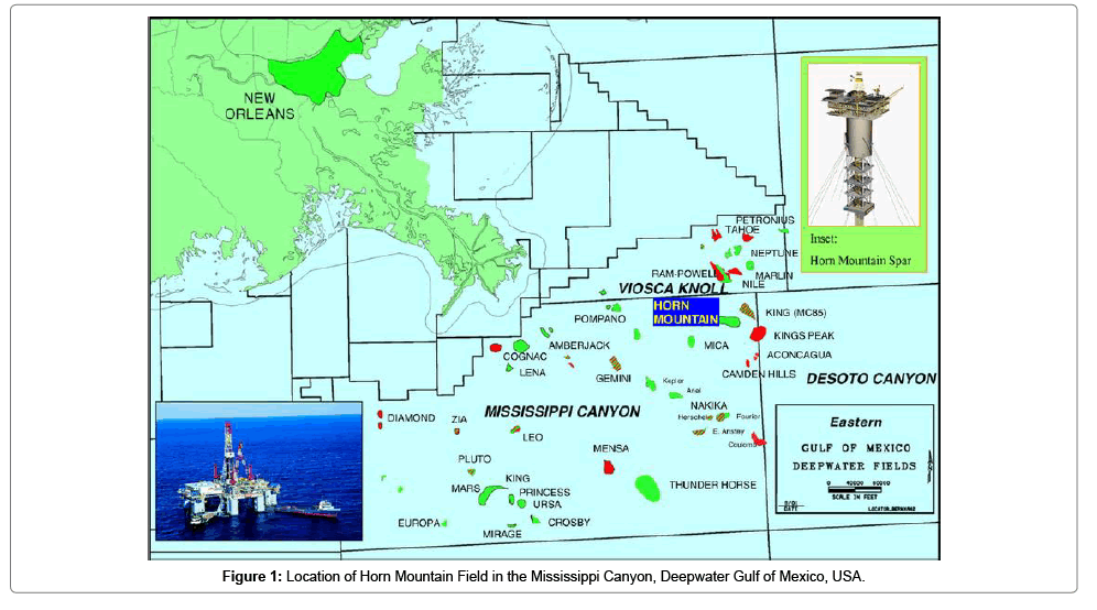
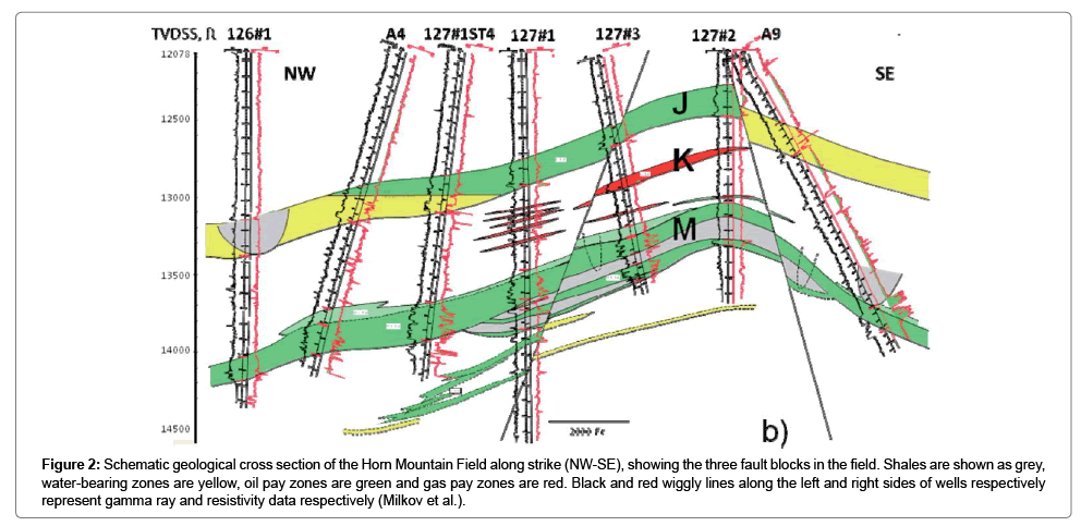
The Horn Mountain Field is located within the Mississippi Canyon at water depth of approximately 5400 ft (1646 m), and covers blocks MC 126 and MC 127 (Figure 1). The Mississippi Canyon is part of the Mississippi submarine valley in the North-central Gulf of Mexico, approximately 290 km southeast of New Orleans, USA. Production from the field, which was discovered in mid-1999, started in late 2002. The field is compartmentalised by faults into three blocks (Figure 2) – northern, central and eastern fault blocks [1].
Figure 2: Schematic geological cross section of the Horn Mountain Field along strike (NW-SE), showing the three fault blocks in the field. Shales are shown as grey, water-bearing zones are yellow, oil pay zones are green and gas pay zones are red. Black and red wiggly lines along the left and right sides of wells respectively represent gamma ray and resistivity data respectively (Milkov et al.).
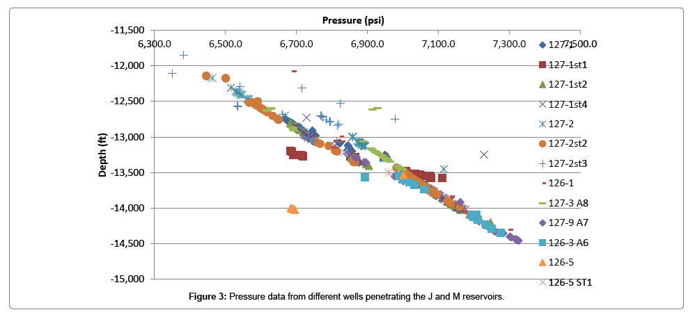
Oil and associated gas are produced from two middle Miocene reservoirs. This is confirmed by pressure data from the Horn Mountain Field. A plot of the pressure data from different wells in the field against depth shows two pressure gradients for oil accumulations (Figure 3). The oil accumulations are contained in the deeper M sand and the shallower J sand reservoirs, with oil pay zones between approximately 12, 200 ft (3719 m) and 14, 200 ft (4328 m) true vertical depth subsea. The field also contains another reservoir, K Sand, between the M Sand and J Sand reservoirs, which contains gas. The K reservoir is, however, thin, discontinuous and areally small.
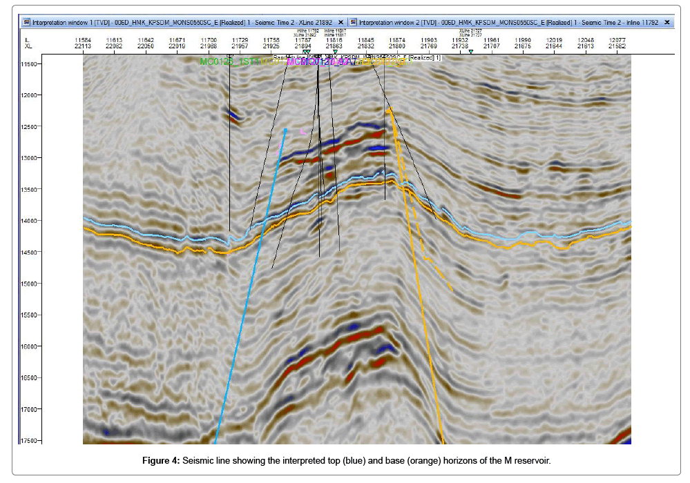
This paper attempts to describe the deeper middle Miocene M Sand reservoir based on geological, geophysical and petrophysical data, as well as published literature on the Horn mountain field. The top and base horizons of the M reservoir along with faults were interpreted from three-dimensional (3-D) seismic data (Figure 4) and used to build a reservoir model with Petrel.
Regional Framework
The Mississippi Canyon, which is an undersea canyon forming part of the Mississippi Submarine Valley, is situated in north-central Gulf of Mexico. The Gulf of Mexico is an ocean basin which formed by initial rifting from the Late Triassic-Early Jurassic and progressed through middle Jurassic. Continued rifting during the Late Jurassic led to seafloor spreading and the formation of oceanic crust. The Gulf of Mexico is characterised by a Jurassic to Pleistocene sedimentary succession [2].
The area is dominated by slope depositional processes and salt tectonics with round, flat-topped salt domes occurring to the east and west of the Canyon. Salt movement occurred in response to gravitational instability as a result of rapid thermal subsidence of the basin [3] as well as varying sedimentation rates during the late Jurassic to early Cretaceous. This was followed by a long period of sediment starvation from the middle Cretaceous to the Oligocene during which the salt remained stable [4]. During the lower and middle Miocene, however, salt deformation restarted mainly due to differential sedimentation. The interaction between the salt (withdrawal) and sediments led to the formation of folded turtle structures which form traps in some parts of the canyon [5]. Normal faults, thrust faults and flanking strike-slip zones were formed above the salt [6,7].
Core Description and Reservoir Framework
The M sand consists mainly of fine to very fine sandstone and silts, with intermittent silty shale and shale. It also comprises coarse sands and mud clasts. The samples appear to be weakly consolidated, with thin, and in some sections, faint shale laminations. Most of the grains are poor to moderately sorted, and showing minimal burial compaction with much of the original pores preserved. Some cements, mainly carbonate cement, but also calcite and quartz cements occur in some parts of the cores. The core samples contain predominantly primary intergranular porosity, although secondary porosity formed by partial dissolution of some grains also contributes a small amount to the overall porosity.
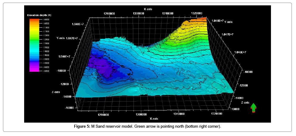
The M Sand reservoir forms a gentle anticlinal fold plunging to the southwest (Figure 5). It is the main reservoir unit in the field containing 80% of reserves trapped in structural/stratigraphic trap. The structural component is provided by a major north-dipping east-west fault north of the field, while the stratigraphic component is made up of southtrending meandering shale-filled bypass channels which trap the oil accumulation in the eastern and north-eastern parts of the field.
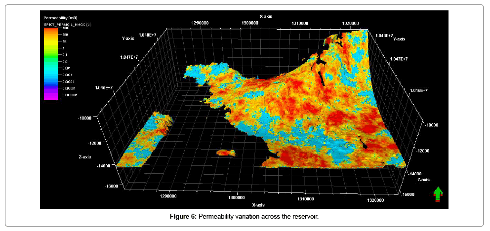
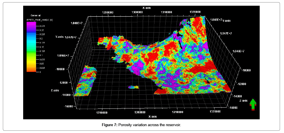
The M reservoir sands are interpreted to have been originally deposited in a deep water turbidite channel-levee-overbank system during the lower to middle Miocene, and comprise interbedded sands, silts and mudstones. It is dominated by sheet-like geometries of varying thickness. These sheet-like sand bodies are vertically stacked as is evident in well logs and core samples. The M sand can be stratigraphically divided into three sections separated by silty shale and shale, which enables easier correlation across the field. The reservoir facies consist of channel-fill, proximal levees and distal levee facies. This variation in facies controls permeability distribution which varies widely across the reservoir (Figure 6) with average values ranging from well over 100 md in distal levees facies to well over 1000 md in channelfill facies. Porosity also varies across the reservoir facies ranging mostly between 0.125 and 0.3 (Figure 7).
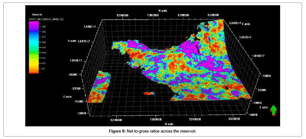
The stacked channel sands predictably form the best reservoir facies in the M reservoir with high net-to-gross ratio as high as 0.9 (Figure 8). The proximal levees and distal levees facies expectedly have lower net-to-gross ratio in decreasing order. Reservoir quality varies across the field and appears to be a function of mud content and cementation. The narrow, thin bedded channel axis component of the channel-levee deposits appear to be of good quality, however, their sinuosity may present some difficulties in development. The reservoir also contains shale-filled channels, and appears to have a jigsaw puzzle layering pattern. There is also occasional pinch out of some of the thin beds laterally.
Uncertainties
Reservoirs are not inherently uncertain; however, uncertainties arise from attempts to describe them. These uncertainties arise as a result of subsurface complexity and limited data. Mitigating these uncertainties usually involves the acquisition of more data and/or improved analysis and understanding of acquired data. Although there are some uncertainties in interpretation, the key uncertainties in the M reservoir models presented here arise from limited data. This is apparent in the models showing the petrophysical properties across the reservoir, in which a large section appears empty. The grid cells in that section have not been populated with the petrophysical properties due to unavailability of such data across that section of the reservoir. This introduces some uncertainties, but does not significantly affect the overall reservoir description.
Conclusions
The M Sand reservoir is the main reservoir unit in the Horn Mountain Field containing 80% of reserves trapped in structural/stratigraphic traps. Oil accumulation in the gentle anticlinal fold of the M Sand is trapped by a major normal fault trending east-west and a shale-filled bypass channel. The reservoir is a structurally and stratigraphically complex turbidite reservoir which is compartmentalised into three fault blocks by several faults. The M reservoir consists of channel-fill, proximal levees and distal levee facies. This facies variation controls permeability across the reservoir. Facies variation and the presence of shale between superimposed sand bodies, form key heterogeneities within the reservoir.
References
- Milkov AV, Goebel E, Dzou L, Fisher DA, Kutch A, et al. (2007) Compartmentalisation and time-lapse geochemical reservoir surveillance of the Horn Mountain oil field, deep-water Gulf of Mexico. AAPG Bulletin 91: 847-876.
- McDonnell A, Loucks RG, Galloway WE (2008) Palaeocene to Eocene deep-water slope canyons, western Gulf of Mexico: Further insights for the provenance of deep-water offshore Wilcox Group plays. AAPG Bulletin 92: 1169-1189
- Rowan MG, Vendeville BC, Peel FJ (2001) The role of salt in gravitational failure of passive margins, In: Fillon RH, Rosen NC, Weimer NC, NC Lawrie NC, Pettingill H, et al. (eds.) Petroleum systems of deep-water basins global and Gulf of Mexico experience: Gulf Coast Section, SEPM 21st Annual Research Foundation Conference: 221-228.
- Combellas-Bigott RI, Galloway WE (2006) Depositional and structural evolution of the middle Miocene depositional episode, east-central Gulf of Mexico. AAPG Bulletin 90: 335-362.
- Chowdhury A (2010) Salt geology and hydrocarbon plays in the northeastern Gulf of Mexico. EAGE first break 28.
- Vendeville BC, Rowan MG (2002) 3-D kinematics of minibasins and salt ridges remobilized by late contraction: physical models and seismic examples southeast Mississippi Canyon, Gulf of Mexico (abs). AAPG Annual Convention Program 11: 182-183.
- Ellis L, Berkman T, Uchytil S, Dzou L (2007) Integration of mud gas isotope logging (MGIL) with field appraisal at Horn Mountain Field, deep-water Gulf of Mexico. J Petrol Sci Eng 58: 443-463.
Citation: Ardo BU, Aminu MD (2018) Reservoir Description of the Middle Miocene M Sand, Horn Mountain Field. Oil Gas Res 4: 155. DOI: 10.4172/2472-0518.1000154
Copyright: © 2018 Ardo BU, et al. This is an open-access article distributed under the terms of the Creative Commons Attribution License, which permits unrestricted use, distribution, and reproduction in any medium, provided the original author and source are credited.
Select your language of interest to view the total content in your interested language
Share This Article
Recommended Journals
Open Access Journals
Article Tools
Article Usage
- Total views: 5331
- [From(publication date): 0-2018 - Dec 04, 2025]
- Breakdown by view type
- HTML page views: 4377
- PDF downloads: 954

