Reconceptualising Pavement Maintenance Decision-Making Using GIS as a Visualisation Tool: A Case Study Exemplar
Received: 01-Mar-2024 / Manuscript No. jaet-24-130346 / Editor assigned: 04-Mar-2024 / PreQC No. jaet-24-130346 (PQ) / Reviewed: 18-Mar-2024 / QC No. jaet-24-130346 / Revised: 23-Mar-2024 / Manuscript No. jaet-24-130346 (R) / Accepted Date: 29-Mar-2024 / Published Date: 29-Mar-2024
Abstract
This study explores how a visualised GIS model can aid decision-making in pavement maintenance management, focusing on roads under Local Road Authorities (LRA) control in the U.K. Factors influencing decision-making in pavement maintenance were identified and ranked through a nationwide questionnaire survey, followed by interviews with LRA experts to validate the rated factors. The Analytical Hierarchy Process (AHP) was employed to configure priority rankings. Subsequently, a GIS-based decision support model was developed and tested using Runnymede roads within Surrey County Council. Fourteen influential factors affecting pavement maintenance were identified and ranked. The GIS model was deemed a rational, simple, and usable tool for pavement management. With growing pressures on LRAs from limited budgets, increased accountability, and ageing roads facing higher traffic loads, efficient decision-making processes are crucial. GIS is a valuable tool for visualising results and optimising pavement maintenance strategies.
Keywords
Pavement Maintenance System (PMS); Geographical Information Systems (GIS); Analytical Hierarchy Procedure (AHP); Highways Management; Local Road Authorities (LRA)
Introduction
For most countries, roads represent the primary mode of transportation. In Europe, roads constitute 83% of surface passenger transport, compared to 17% for rail. This underscores the significant role of roads as one of the largest and most vital national assets, often under public ownership (World Road Association, 2014). The World Road Association (2014) emphasises that well-maintained roads are crucial for economic growth, facilitating the movement of goods and passengers despite the increasing traffic volume pressures on the pavement. They contribute to the national Gross Domestic Product (GDP) and enhance social welfare. Therefore, pavement maintenance is fundamental to modern highway management [1].
As such, many factors influence the need for pavement maintenance, including the prioritisation and utilisation of funds [2]. Deteriorating pavement conditions inevitably jeopardise human safety [3]. Over time, pavements degrade in strength and quality due to the pressure exerted by heavy loads and Exposure to environmental elements. Additionally, utility equipment installation and upkeep further contribute to pavement wear and tear [4]. Consequently, pavement maintenance management systems (PMMSs) were initially introduced in the 1960s [4] to address the need for more cost-effective funding mechanisms and long-term planning of road projects. These systems aimed to provide lasting solutions to the numerous unforeseen pavement failures experienced by the Canadian and American road networks at the time. An ideal maintenance scheme ensures that all pavement sections maintain a sufficiently high level of functional and structural condition [6]. However, due to the escalating traffic volume on roads, timely repairs, which are often crucial, are constrained by factors such as time, budget, and resource availability, including workforce and equipment. This underscores the importance of prioritising and scheduling pavement sections for maintenance, a critical aspect of PMMSs [7]. PMMSs are commonly employed by local road authorities (LRA) to improve decision-making processes, providing insights into decision implications and helping to mitigate adverse impacts and maintenance costs.
This research presents a systematic method for identifying the key factors influencing pavement maintenance prioritisation for local road authorities (LRAs) by integrating PMMS with Geographic Information System (GIS) capabilities. GIS is increasingly gaining traction in transportation engineering due to its unique features, such as spatial analysis and visualisation, which can significantly improve pavement management practices. To illustrate the effectiveness of visualisation in pavement management, a case study will be conducted using roads from a specific area in the U.K. (Runnymede, Surrey).
GIS in pavement maintenance and management
PMMSs were first introduced in the 1960s [5] to address the need to provide more cost-effective mechanisms for funding and future planning of road projects. They also provided lasting solutions to the countless unanticipated pavement failures in the Canadian and American road networks at the time. Nowadays, some PMMS tools incorporate visual technology to enhance decision-making, with varying degrees of success [8].
[9,10] advocate that GIS is a suitable choice to base a PMMS due to the spatial nature of road data, where GIS has the capability of storing, integrating, mapping, displaying, querying, and spatially analysing road data. [11] developed a GIS-based road maintenance management tool, demonstrating the efficiency in decision-making regarding maintenance prioritisation of road networks. Moreover, [12] conducted a study on GIS as a support tool for pavement maintenance strategy selection. They concluded that using GIS in pavement management has proved successful due to its data analysis, query, and visual representation capability. This research ensues and provides a case study exemplar to demonstrate and reconceptualise the practical approach of using GIS to support PMMS.
Research methodology
This study employs a mixed methods approach to develop a visualised GIS model to support decision-making in pavement maintenance management. A mixed-methods approach enhances the validity of the research, surpassing the limitations of single-method studies [13]. The data collection methods employed in this study was comprehensive and involved the following steps. Firstly, a thorough literature review identified 14 factors influencing pavement maintenance. Secondly, professionals from various local road authorities (LRAs) participated in two approaches to rank these 14 factors:
Questionnaire survey:A questionnaire survey was distributed via email to 195 road managers representing a majority of local road authorities in the U.K. The aim was to establish a consensus among LRAs on the most significant factors affecting pavement maintenance and to determine the relative weight (ranking priority) assigned to each factor by different experts. The survey received 67 responses, resulting in a response rate of 34%.
Interviews:Five interviews were conducted with experts from different LRAs in the U.K. to validate the factors identified in the questionnaire. Interviewees were asked to rate the factors and explain the rationale behind their ratings. The interview statements were then compared with the survey responses using a triangulation approach to ensure data validity.
Data obtained from the questionnaires yielded a roster of pavement maintenance management factors, which were ranked by respondents based on their perceived significance. This data was quantitative, as it involved numerical rankings-similarly, data from the interviews provided both quantitative and qualitative insights. Quantitatively, factors were ranked or weighted numerically, while qualitatively, experts offered additional justifications and descriptions of the factors. To ensure the reliability of the collected data, SPSS (Statistical Package for the Social Sciences) was employed in the third stage of the research to compute Cronbach's alpha, assessing internal consistency among responses. The study maintains construct validity, as findings from both the questionnaire and interviews align. Subsequently, the Analytical Hierarchy Process (AHP) was utilised in the fourth stage as the multi-criteria decision method for developing the GIS-based model in stage five. This model aims to facilitate multi-criteria decision-making in pavement maintenance management, with Runnymede (within Surrey County Council) serving as a case study exemplar.
Stage 1 and 2 findings: Factors affecting pavement maintenance prioritisation decisions
Table 1 presents 14 factors identified through an extensive literature review as the most influential elements affecting pavement maintenance [6,9,11,14-20]. These factors were subsequently utilised to inform prioritisation decisions in pavement maintenance schemes.
| Factor Number | Factor |
|---|---|
| F1 | Remaining Service Life |
| F2 | Road Condition Indicator (RCI) |
| F3 | Type of Deterioration |
| F4 | Observed Deterioration Rate |
| F5 | Traffic Diversion |
| F6 | Importance of Road/Classification |
| F7 | Annual Average Daily Traffic (AADT) |
| F8 | Possible Conflict or Overlap with Other Road Works |
| F9 | Risk of failure |
| 10 | Safety Concern |
| F11 | Accident Rate (related to surface condition) |
| F12 | Scheme Cost |
| F13 | Available Budget/Funding |
| F14 | Whole Life-Cycle Cost |
Table 1: Pavement Maintenance Prioritisation Factors Included in the study
Table 2 shows the responses to both the questionnaire and survey conducted in LRAs. Respondents were asked to list each factor in rank/ priority order from 1 to 5 (5 being critical); the responses are shown along with the total and mean values (rating values) for each factor. Factors are ranked according to their mean values to establish a pattern in the attitude of local road authorities to pavement maintenance management.
| Factor | 64 questionnaire responses | 5 interview responses | ||||||||||||||
|---|---|---|---|---|---|---|---|---|---|---|---|---|---|---|---|---|
| Rating Score | Total Score ∑ | Mean x ̀ |
Rank | Rating Score | Total Score ∑ | Mean x ̀ |
Rank | |||||||||
| 1 | 2 | 3 | 4 | 5 | 1 | 2 | 3 | 4 | 5 | |||||||
| F1 | 2 | 1 | 15 | 16 | 33 | 278 | 4.15 | 4 | 0 | 0 | 1 | 2 | 1 | 16 | 4 | 5 |
| F2 | 1 | 4 | 14 | 32 | 16 | 259 | 3.87 | 8 | 0 | 0 | 2 | 2 | 0 | 14 | 3.5 | 9 |
| F3 | 1 | 3 | 14 | 32 | 17 | 262 | 3.91 | 6 | 0 | 0 | 0 | 4 | 0 | 16 | 4 | 5 |
| F4 | 2 | 5 | 16 | 23 | 21 | 257 | 3.84 | 9 | 0 | 0 | 1 | 3 | 0 | 15 | 3.75 | 7 |
| F5 | 7 | 10 | 19 | 19 | 12 | 220 | 3.28 | 12 | 0 | 0 | 3 | 1 | 0 | 12 | 3.25 | 13 |
| F6 | 0 | 0 | 12 | 29 | 26 | 282 | 4.21 | 3 | 0 | 0 | 0 | 3 | 1 | 17 | 4.25 | 2 |
| F7 | 3 | 14 | 21 | 24 | 5 | 215 | 3.21 | 14 | 0 | 2 | 0 | 2 | 0 | 12 | 3 | 13 |
| F8 | 2 | 4 | 22 | 22 | 17 | 249 | 3.72 | 11 | 0 | 1 | 1 | 2 | 0 | 13 | 3.25 | 10 |
| F9 | 4 | 4 | 11 | 25 | 23 | 260 | 3.88 | 7 | 0 | 0 | 1 | 3 | 0 | 15 | 3.75 | 7 |
| F10 | 2 | 1 | 7 | 21 | 36 | 289 | 4.31 | 2 | 0 | 0 | 1 | 1 | 2 | 17 | 4.25 | 2 |
| F11 | 4 | 4 | 9 | 24 | 26 | 265 | 3.96 | 5 | 1 | 0 | 1 | 1 | 1 | 13 | 3.25 | 10 |
| F12 | 4 | 11 | 23 | 21 | 8 | 219 | 3.27 | 13 | 0 | 0 | 3 | 1 | 0 | 13 | 3.25 | 10 |
| F13 | 2 | 0 | 7 | 13 | 45 | 300 | 4.48 | 1 | 0 | 0 | 0 | 1 | 3 | 19 | 4.75 | 1 |
| F14 | 2 | 7 | 16 | 22 | 20 | 252 | 3.76 | 10 | 0 | 0 | 0 | 3 | 1 | 17 | 4.25 | 2 |
Table 2: Data Collection Responses from Survey and Interviews on Pavement Maintenance Prioritisation Factors
From the survey responses provided by 67 representatives of local road authorities, it is apparent that the factor with the highest rating is Available Budget/Funding (F13). In contrast, the lowest rating is attributed to Annual Average Daily Traffic (AADT) (F7). The findings from the 5 interviews further confirmed the significance of Available Funding (F13) in pavement maintenance management. At the same time, Annual Average Daily Traffic (F7) was identified as the least influential factor in pavement maintenance prioritisation. As mentioned, ranking factors aimed to validate the questionnaire survey outcomes by aligning them with the interview results. A slight discrepancy between the interview and questionnaire results was observed, underscoring the necessity to verify the reliability and validity of the data.
Stage 3: Reliability and validity of prioritisation factors
To ensure the prioritisation process's reliability and validity, the data quality was assessed, and dependable findings were established in accordance with earlier stages [21,22]. The internal consistency of responses across all participants was evaluated using Cronbach's alpha, a reliability coefficient calculated through SPSS (Statistical Package for the Social Sciences) [23].
Cronbach's alpha values vary between 0 and 1, where values of 0.7 and above indicate that the questions combined in the scale measure the same thing [23]. However, when the value of Cronbach's alpha is less than 0.7, the reliability can be increased by removing an item or more from the questionnaire. The analysis was performed for all questions, and the values of Cronbach's alpha were more significant than 0.7. This indicates that the responses for all questions have internal consistency; therefore, the results from the analysis have internal consistency and are thus reliable, as seen in Table 3.
| Factor No. | Factor | Original Cronbach’s Alpha Value | Items for Deletion | Cronbach’s Alpha Value if Item Deleted |
|---|---|---|---|---|
| F1 | Remaining Service Life | 0.74 | _ | 0.74 |
| F2 | Road Condition Indicator (RCI) | _ | 0.74 | |
| F3 | Type of Deterioration | _ | 0.706 | |
| F4 | Observed Deterioration Rate | _ | 0.729 | |
| F5 | Traffic Diversion | _ | 0.726 | |
| F6 | Importance/Classification of Road | _ | 0.725 | |
| F7 | Annual Average Daily Traffic (ADDT) | _ | 0.718 | |
| F8 | Possible Conflict or Overlap with Other Road Works | _ | 0.729 | |
| F9 | Risk of Failure | _ | 0.722 | |
| 10 | Safety Concern | _ | 0.725 | |
| F11 | Accident Rate (related to surface condition) | _ | 0.713 | |
| F12 | Scheme Cost | _ | 0.725 | |
| F13 | Available Funding | _ | 0.723 | |
| F14 | Whole Life-cycle Cost | _ | 0.726 |
Table 3: The Results of Reliability Analysis
Stage 4: Prioritisation of the factors for pavement maintenance using the AHP method
Once the LRA's rating of factors affecting pavement maintenance prioritisation was undertaken, the multi-criteria decision method Analytical Hierarchy Process (AHP) was used to develop the visual GIS model to illustrate the prioritisation of the given factors. According to AHP [24], factor weights are yielded through pairwise comparisons of rated factors to establish an Importance Matrix (I.M.). The latter, in turn, yields a more precise ranking of factors organised according to their significance. The normalisation of the paired matrix provides the importance attached to each factor. The design of the Importance Matrix can be seen below [9].
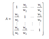
Where,
w1= rating value for factor 1 (F1),
wn= rating value for factor n (Fn).
Table 4 shows the rating values for each of the 14 factors.
Subsequently, the weights of each factor formed the element of the rating methodology employed for evaluating alternatives (roads). Upon pairwise comparison of the factor rating values of the rating values as per Table 4, Figure 1 is produced via Excel.
| Factors | Rating Values for Factors (w) | |
|---|---|---|
| F1 | w1 | 4.15 |
| F2 | w2 | 3.87 |
| F3 | w3 | 3.91 |
| F4 | w4 | 3.84 |
| F5 | w5 | 3.28 |
| F6 | w6 | 4.21 |
| F7 | w7 | 3.21 |
| F8 | w8 | 3.72 |
| F9 | w9 | 3.88 |
| F10 | w10 | 4.31 |
| F11 | w11 | 3.96 |
| F12 | w12 | 3.27 |
| F13 | w13 | 4.48 |
| F14 | w14 | 3.76 |
Table 4: Rating Values for Factors

Figure 1: Calculated Importance Matrix (Paired Matrix).
The eigenvalue method is used to calculate the relative weights of factors in the pairwise comparison matrix. The relative weights (W) of matrix an are obtained from the following equation [9]:
Where,
(A−λmax I)×W=0
λmax= the most significant eigenvalue of matrix A
I= unit matrix
The eigenvalueλmax and the eigenvector (Weights of Factors) were calculated using MATLAB R2015a computation software, and the results are shown in Figure 2.

Figure 2: Weights of Factors (Eigenvector).
λmax =14
Figure 3 shows the normalised factors' weight of importance; the sum of all factors equals 1.
The outcome in Figure 3 shows that the ranking sequence does not differ from Table 4. Normalised factor weights singled out F13 as the most crucial factor (0.083186 out of 1) and F7 as the most negligible factor (0.059610 out of 1). According to [25], the consistency ratio (C.R.) demonstrates the degree of compatibility of data analysed through the AHP method. Thus, by definition, the consistency ratio reveals any potential incompatibility in subjective matrix scores. The consistency ratio should be less than or equal to 0.1 for the latter to be deemed acceptable. The consistency ratio formula is:

Figure 3: Factors’ Weight of Importance.
C.R. = CI / RI
Where CI stands for the consistency index, and R.I. – for the random index:

The formulas above demonstrate calculating consistency about the largest eigenvalue. The largest eigenvalue λmax (allowing for deviations owing to the large numbers) was obtained via MATLAB R2015a computation software as "14", and when it is applied within the equation given above, where n is the size of the matrix, CI is calculated as "0". In random matrices, the R.I. is the mean value of CI. R.I. values for the matrices comprising N elements (for different matrix orders) are shown in Table 5 [9].
This study employed an order of magnitude of the pairwise comparison matrix equal to 14, which yields an R.I. value of 1.57. The consistency ratio of the comparison process is then calculated using the CI and R.I. values obtained above:
CR = CI / RI = 0 / 1.57 = 0
| N | 1 | 2 | 3 | 4 | 5 | 6 | 7 | 8 | 9 | 10 | 11 | 12 | 13 | 14 | 15 |
|---|---|---|---|---|---|---|---|---|---|---|---|---|---|---|---|
| RI | 0 | 0 | 0.6 | 0.9 | 1.12 | 1.24 | 1.32 | 1.4 | 1.45 | 1.49 | 1.51 | 1.48 | 1.56 | 1.57 | 1.6 |
Table 5: Average Random Consistency (R.I.)
The C.R. value being lower than 0.1 means that consistency is corroborated in the comparison process.
Developing a conceptual model for pavement maintenance
In summary, a 5-step approach is proposed for the development of the proposed GIS-based Pavement Maintenance Management model to manage pavement maintenance effectively:
Step 1:Identifying Factors Affecting Pavement Maintenance Management. Before examining other components of the proposed model, it is essential to identify the factors that influence the prioritisation process of pavement maintenance. These factors can influence the model's performance and efficiency. In this study, 14 critical factors were identified through a literature review that should be considered for the proposed model of pavement maintenance management.
Step 2:Processing Mechanism and Appropriate Procedure. AHP was adopted in this study to estimate the relative weights of different factors considered in the spatial analysis process, prioritise pavement maintenance, and determine the relative ranking of alternatives. Calculation of weights of factors was the first stage of the stated AHP algorithm. To determine the relative ranking of alternatives [roads], a priority matrix should be determined by assigning scores for factors according to their classification, which will be achieved in the next phase.
Step 3:Classification and Assigning Scale of the Model’s Parameters. In this phase, a scale of 1 to 3 was used for the assigned data in the priority matrix, where 1 represents the least attention the pavement needs to be maintained, 2 represents intermediate attention, and 3 represents immediate attention. However, some factors will also be classified and scored based on rational judgment.
Step 4:Calculation of Pavement Maintenance Priority Score (PMPS). The next step will calculate the PMPS, which indicates the ranking of alternatives. This is done by multiplication of the priority matrix and the vector of factors' weights. The output of this calculation is the vector that indicates the ranking of alternatives. The AHP algorithm used to calculate the Priority Score is presented as follows:
PMPS =Fi Wi
i= 1 to 14
Where,
F = Score of Factor (1 to 3)
W = Weight of Factor
Step 5:Application of the Model for Pavement Maintenance Priority. The outcome of the calculated PMPS in phase 4 will be integrated into GIS to form the final model. The final model is applied by using a case study of Runnymede within the Surrey County Council to test the proposed model. This will help to check that it can be used and applied within similar local road authorities. Second, the conceptual distinctions of the model are outlined with an emphasis on the data fed into and out of it. The calculated AHP algorithm is then integrated into the GIS platform via Excel software.
Stage 5: Prototyping for testing and validation
This section outlines the development of the GIS model prototype, aimed at testing and validating its efficacy as a decision support tool for prioritising pavement maintenance. The objective is to optimise the allocation of limited resources by LRAs to pavement management. Initially, the model was tested using 25 roads in Runnymede, Surrey, selected for their representative nature. Runnymede, situated in the prosperous London commuter belt, was chosen collaboratively with Surrey County Council. Displays the geographical layout of Runnymede roads, while Table 6 lists the names of the 25 roads included in the base map.
| A30 | A308 | A317 | A318 | A319 | A320 | A328 | A329 | |
| B3121 | B3376 | B3407 | B375 | B385 | B386 | B387 | B388 | B389 |
| C10 | C125 | C126 | C127 | C128 | C129 | C130 | C229 | |
Table 6: Names of the Roads in Runnymede Used as Case Study.
The next step was to assign the data layer of Runnymede roads to the digital map and then import the database for the calculated ranking of alternatives (roads) into ArcGIS software. A scale of 1 to 3 was used for the factors according to their classification. Then the scores of the 14 factors of 1, 2, or 3 were assigned to each road to form the priority matrix, where 1 represents the least attention for the pavement to be maintained, 2 represents intermediate attention for the pavement to be maintained, and 3 represents immediate attention for the pavement to be maintained.
Road condition indicator (RCI)
The road network condition is reported nationally using a U.K. standard RCI, which LRAs adopt, as it is concluded in the code of practice for highway maintenance management. The RCI takes account of four parameters: rutting, texture, longitudinal profile, and cracking. To present the results graphically in the proposed model, a colour coding convention has been adopted using the traffic light system as follows as per Table 7.
| RCI | Colour Coding | Scale |
|---|---|---|
| ≤ 40 | Green | 1 |
| 41 to 100 | Amber | 2 |
| > 100 | Red | 3 |
Table 7: Classification and Scale for Road Condition Indicator RCI Factor. Source: and Author scaling
Green:The road surface is generally in good condition.
Amber:The road surface has some deterioration; hence, further investigation is needed to determine the best time for planned maintenance.
Red:The road surface is in poor overall condition and likely to require planned maintenance soon. [21]
Solving pavement maintenance priority score (pmps) equation
The aforementioned PMPS equation is calculated to achieve the overall PMPS. Based on Road Name, an Excel spreadsheet is integrated into ArcGIS software with the GIS base map layer of Runnymede roads, as shown in Figure 4, Figure 5, Table 8 and Table 9, illustrate the calculation of overall PMPS and the distribution of alternative roads, respectively.

Figure 4: Base Map for Runnymede Roads.

Figure 5: PMPS Distribution of Roads in Runnymede.
| Road No. | Road Name | F1 | F2 | F3 | F4 | F5 | F6 | F7 | F8 | F9 | F10 | F11 | F12 | F13 | F14 | Weights | PMPS | ||
|---|---|---|---|---|---|---|---|---|---|---|---|---|---|---|---|---|---|---|---|
| R1 | A30 | 2 | 2 | 2 | 2 | 2 | 2 | 2 | 2 | 2 | 2 | 2 | 2 | 2 | 2 | 0.077064 | 2 | ||
| 0.071854 | |||||||||||||||||||
| 0.072606 | |||||||||||||||||||
| 0.071317 | |||||||||||||||||||
| x | = | ||||||||||||||||||
| 0.060899 | |||||||||||||||||||
| 0.078191 | |||||||||||||||||||
| 0.05961 | |||||||||||||||||||
| 0.069089 | |||||||||||||||||||
| R2 | A308 | 1 | 1 | 1 | 1 | 1 | 1 | 1 | 1 | 1 | 1 | 1 | 1 | 1 | 1 | 1 | |||
| R3 | A317 | 3 | 3 | 3 | 2 | 1 | 1 | 1 | 2 | 1 | 1 | 2 | 1 | 2 | 1 | 1.74019 | |||
| R4 | A318 | 3 | 3 | 1 | 1 | 1 | 1 | 1 | 2 | 2 | 2 | 1 | 1 | 1 | 1 | 1.51901 | |||
| R5 | A319 | 2 | 1 | 1 | 1 | 1 | 2 | 2 | 2 | 2 | 1 | 1 | 1 | 1 | 1 | 0.072042 | 1.356 | ||
| R6 | A320 | 3 | 1 | 1 | 3 | 1 | 3 | 3 | 3 | 3 | 3 | 3 | 3 | 3 | 3 | 2.58928 | |||
| R7 | A328 | 2 | 1 | 1 | 1 | 3 | 1 | 1 | 1 | 1 | 1 | 1 | 1 | 1 | 1 | 1.19886 | |||
| R8 | A329 | 2 | 3 | 2 | 3 | 3 | 3 | 3 | 3 | 3 | 3 | 1 | 1 | 3 | 3 | 2.58176 | |||
| R9 | B3121 | 1 | 1 | 1 | 1 | 1 | 3 | 1 | 1 | 1 | 1 | 1 | 1 | 2 | 1 | 0.080044 | 1.23957 | ||
| R10 | B3376 | 3 | 2 | 2 | 2 | 3 | 2 | 1 | 1 | 1 | 1 | 3 | 1 | 1 | 1 | 1.71699 | |||
| R11 | B3407 | 2 | 1 | 1 | 3 | 1 | 1 | 1 | 1 | 1 | 1 | 1 | 2 | 1 | 1 | 1.28044 | |||
| R12 | B375 | 3 | 3 | 3 | 3 | 3 | 3 | 3 | 3 | 3 | 3 | 3 | 3 | 3 | 3 | 3 | |||
| R13 | B385 | 1 | 1 | 1 | 1 | 1 | 3 | 1 | 1 | 1 | 1 | 1 | 2 | 1 | 1 | 0.073546 | 1.21712 | ||
| R14 | B386 | 2 | 1 | 1 | 1 | 3 | 1 | 1 | 1 | 1 | 1 | 1 | 2 | 1 | 1 | 1.2596 | |||
| R15 | B387 | 3 | 3 | 3 | 3 | 3 | 3 | 3 | 3 | 3 | 3 | 2 | 2 | 2 | 1 | 2.6429 | |||
| R16 | B388 | 1 | 1 | 1 | 1 | 1 | 1 | 1 | 1 | 1 | 1 | 1 | 2 | 1 | 1 | 1.06074 | |||
| R17 | B389 | 2 | 3 | 3 | 3 | 2 | 2 | 2 | 2 | 1 | 1 | 1 | 1 | 1 | 1 | 0.060738 | 1.77641 | ||
| R18 | C10 | 3 | 3 | 3 | 3 | 3 | 3 | 3 | 3 | 3 | 3 | 3 | 1 | 1 | 1 | 2.57252 | |||
| R19 | C125 | 1 | 1 | 1 | 1 | 1 | 1 | 1 | 1 | 1 | 1 | 1 | 1 | 1 | 1 | 1 | |||
| R20 | C126 | 1 | 1 | 2 | 2 | 3 | 3 | 3 | 3 | 3 | 2 | 2 | 2 | 2 | 2 | 2.19091 | |||
| R21 | C127 | 2 | 1 | 1 | 1 | 1 | 1 | 1 | 1 | 1 | 1 | 3 | 1 | 1 | 1 | 0.083186 | 1.22416 | ||
| R22 | C128 | 1 | 1 | 1 | 1 | 1 | 3 | 2 | 1 | 1 | 1 | 1 | 1 | 1 | 1 | 1.21599 | |||
| R23 | C129 | 3 | 3 | 2 | 2 | 2 | 2 | 3 | 3 | 3 | 3 | 3 | 3 | 3 | 3 | 2.71699 | |||
| R24 | C130 | 2 | 2 | 2 | 2 | 2 | 2 | 2 | 2 | 2 | 1 | 1 | 1 | 1 | 1 | 1.63267 | |||
| R25 | C229 | 1 | 1 | 1 | 1 | 1 | 1 | 3 | 3 | 3 | 1 | 1 | 1 | 1 | 1 | 0.069814 | 1.40148 | ||
Table 8: Calculation of overall PMPS for Runnymede.
The features of ArcGIS 10 software have been used to combine the data in Table 9 with data in the attribute table of the base map of the Runnymede roads layer. Priority values were classified into 3 classes using the Symbology feature, and natural breaks were selected with three colours to represent each class. The prioritised roads are shown in Figure 6.
| Road No. | F1 | F2 | F3 | F4 | F5 | F6 | F7 | F8 | F9 | F10 | F11 | F12 | F13 | F14 | PMPS |
|---|---|---|---|---|---|---|---|---|---|---|---|---|---|---|---|
| R1 | 2 | 2 | 2 | 2 | 2 | 2 | 2 | 2 | 2 | 2 | 2 | 2 | 2 | 2 | 2 |
| R2 | 1 | 1 | 1 | 1 | 1 | 1 | 1 | 1 | 1 | 1 | 1 | 1 | 1 | 1 | 1 |
| R3 | 3 | 3 | 3 | 2 | 1 | 1 | 1 | 2 | 1 | 1 | 2 | 1 | 2 | 1 | 1.740186 |
| R4 | 3 | 3 | 1 | 1 | 1 | 1 | 1 | 2 | 2 | 2 | 1 | 1 | 1 | 1 | 1.519011 |
| R5 | 2 | 1 | 1 | 1 | 1 | 2 | 2 | 2 | 2 | 1 | 1 | 1 | 1 | 1 | 1.355996 |
| R6 | 3 | 1 | 1 | 3 | 1 | 3 | 3 | 3 | 3 | 3 | 3 | 3 | 3 | 3 | 2.589282 |
| R7 | 2 | 1 | 1 | 1 | 3 | 1 | 1 | 1 | 1 | 1 | 1 | 1 | 1 | 1 | 1.198862 |
| R8 | 2 | 3 | 2 | 3 | 3 | 3 | 3 | 3 | 3 | 3 | 1 | 1 | 3 | 3 | 2.581762 |
| R9 | 1 | 1 | 1 | 1 | 1 | 3 | 1 | 1 | 1 | 1 | 1 | 1 | 2 | 1 | 1.239568 |
| R10 | 3 | 2 | 2 | 2 | 3 | 2 | 1 | 1 | 1 | 1 | 3 | 1 | 1 | 1 | 1.716986 |
| R11 | 2 | 1 | 1 | 3 | 1 | 1 | 1 | 1 | 1 | 1 | 1 | 2 | 1 | 1 | 1.280436 |
| R12 | 3 | 3 | 3 | 3 | 3 | 3 | 3 | 3 | 3 | 3 | 3 | 3 | 3 | 3 | 3 |
| R13 | 1 | 1 | 1 | 1 | 1 | 3 | 1 | 1 | 1 | 1 | 1 | 2 | 1 | 1 | 1.21712 |
| R14 | 2 | 1 | 1 | 1 | 3 | 1 | 1 | 1 | 1 | 1 | 1 | 2 | 1 | 1 | 1.2596 |
| R15 | 3 | 3 | 3 | 3 | 3 | 3 | 3 | 3 | 3 | 3 | 2 | 2 | 2 | 1 | 2.642902 |
| R16 | 1 | 1 | 1 | 1 | 1 | 1 | 1 | 1 | 1 | 1 | 1 | 2 | 1 | 1 | 1.060738 |
| R17 | 2 | 3 | 3 | 3 | 2 | 2 | 2 | 2 | 1 | 1 | 1 | 1 | 1 | 1 | 1.776407 |
| R18 | 3 | 3 | 3 | 3 | 3 | 3 | 3 | 3 | 3 | 3 | 3 | 1 | 1 | 1 | 2.572524 |
| R19 | 1 | 1 | 1 | 1 | 1 | 1 | 1 | 1 | 1 | 1 | 1 | 1 | 1 | 1 | 1 |
| R20 | 1 | 1 | 2 | 2 | 3 | 3 | 3 | 3 | 3 | 2 | 2 | 2 | 2 | 2 | 2.190913 |
| R21 | 2 | 1 | 1 | 1 | 1 | 1 | 1 | 1 | 1 | 1 | 3 | 1 | 1 | 1 | 1.224156 |
| R22 | 1 | 1 | 1 | 1 | 1 | 3 | 2 | 1 | 1 | 1 | 1 | 1 | 1 | 1 | 1.215992 |
| R23 | 3 | 3 | 2 | 2 | 2 | 2 | 3 | 3 | 3 | 3 | 3 | 3 | 3 | 3 | 2.716987 |
| R24 | 2 | 2 | 2 | 2 | 2 | 2 | 2 | 2 | 2 | 1 | 1 | 1 | 1 | 1 | 1.632672 |
| R25 | 1 | 1 | 1 | 1 | 1 | 1 | 3 | 3 | 3 | 1 | 1 | 1 | 1 | 1 | 1.401482 |
Table 9: PMPS Distribution of Roads in Runnymede.

Figure 6: Classified Maintenance Priority for Roads in GIS.
•Red-coloured roads indicate immediate maintenance action is required, and roads A320, A329, B375, B387, C10, and C129 achieved the highest PMPS of 2.589282, 2.581762, 3.0, 2.642902, 2.572524, and 2.716987, respectively.
•Amber-colouredAmber-coloured roads indicate a moderate maintenance action required, where roads A30, A317, A318, B389, B3376, C126, C130, and C229 achieved the medium PMPS of 2.0, 1.740186, 1.519011, 1.776407, 1.716986, 2.190913, 1.632672, and 1.401482, respectively.
•Green-coloured roads indicate the least maintenance action required, where roads A308, A319, A328, B3121, B3407, B385, B386, B388, C125, C127 and C128 achieved the lowest PMPS of 1.0, 1.355996, 1.198862, 1.239568, 1.280432, 1.217120, 1.2596, 1.060739, 1.0, 1.224156 and 1.215992, respectively.
In order to visualise each road by its priority score, priority values were classified into 23 classes as, on two occasions, two different roads achieved the same priority score value (R2 and R19). Figure 7 shows the 25 roads with a colour scheme where the darkest colour represents the highest PMPS and the lightest colour represents the lowest PMPS.

Figure 7: PMPS for Roads in GIS.
Ranking of alternative roads
The PMPS equation represents the priority of roads regarding pavement maintenance. Higher scores indicate a greater need for pavement maintenance. The highest priority of Runnymede roads is R12 (B375), and the lowest priority is R2 (A308) and R19 (C125). In order to visualise and demonstrate the ranking of the 25 roads concluded in the case study, a GIS analysis has been performed. Therefore, the ranking of roads is visualised in the GIS
References
- Aziz Z, Qasim RM, Wajdi S (2017) Improving productivity of road surfacing operations using value stream mapping and discrete event simulation. Construction Innovation 29: 1-6.
- Burningham S, Stankevich N (2005) why road maintenance is essential and how to get it done. Transport 1-10.
- World Bank, (2011) Construction and maintenance. Vision to Impact.
- Surrey County Council (2017) Maintaining our roads and pavements. Balt J Road Bridge Eng 11: 242-249
- Kulkarni RB, Miller RW (2002) Pavement Management Systems: Past, Present and Future. TRR 1853.
- Agarwal P, Animesh D, Chakraborty P (2004) A Rational Approach for Prioritisation of Highway Sections for Maintenance. Transp Res Procedia 25: 1-12.
- Fwa TF, Chan WT (1993) Priority Rating of Highway Maintenance Needs by Neural Networks. J Transp Eng 119: 419-432.
- Abo-Hashema MA, Abdel Samad AM, Al-Zaroni Y (2006) Pavement maintenance management practices and GIS in Al-Ain.
- Ibraheem A, Falih D (2012) Applying geographic information system (GIS) for maintenance strategy selection. Engineering 4: 44-54.
- Yunus MZBM, Hassan HB (2010) Managing road maintenance using geographic information system application. J Geogr Inf Syst 2: 215.
- Shrestha PP, Pradhananga N (2009) GIS-based Road Maintenance Management. IWCCE 24-27
- Adeleke OO, Kolo SS, Odumosu JO, Abdulrahman HS, Atilola BY (2015) Application of GIS as Support Tool for Pavement Maintenance Strategy Selection. J Eng Technol 4: 24-30
- Johnson RB, Onwuegbuzie AJ (2004) Mixed methods research: A research paradigm whose time has come. Educational researcher 33: 14-26.
- Abo-Hashema MA, Sharaf EA (2004) A simplified maintenance decision system for flexible pavements in developing countries. Int J Pavement Eng 10: 173-187.
- Parida M (2005) Enhancing pavement management systems using GIS. Proc Inst Civ Eng: Transp 158: 107-113.
- Adlinge SS, Gupta AK (2008) Pavement Deterioration and Its Cause. IOSRJMCE 09-15
- Ziad, T (2009) Bridge Asset Management: A Framework for Best Practice and Artificial Intelligence Models to Aid Multi-Criteria Decision Making. PhD research thesis.
- Ibraheem AT, Atia NS (2012) New Methods in Pavement Maintenance Strategy Selection: Coupling of Decision Making with Analytical Hierarchy Process. LLAP.
- Pantha BR, Yatabe R, Bhandary NP (2010) GIS-based highway maintenance prioritisation model: an integrated approach for highway maintenance in Nepal Mountains. J Transp Geogr 18: 426-433.
- Alfar E (2016) GIS-based Pavement Maintenance Management Model for Local Roads in the UK. PhD research thesis.
- Robson C (2011) Real World Research, 3rd edition. Wiley.
- Zohrabi M (2013) Mixed Method Research: Instruments, Validity, Reliability and Reporting Findings. TPLS 3: 254-262.
- Saunders M, Lewis P, Thornhill A (2012) Research Methods for Business Students 6th ed. Essex: Pearson.
- Saaty TL (1980) the Analytic Hierarchy Process. Education 1-11.
- Saaty TL (2008) Decision-making with the analytic hierarchy process. IJSSci 83-98.
Indexed at, Google Scholar, Crossref
Indexed at, Google Scholar, Crossref
Indexed at, Google Scholar, Crossref
Indexed at, Google Scholar, Crossref
Indexed at, Google Scholar, Crossref
Indexed at, Google Scholar, Crossref
Indexed at, Google Scholar, Crossref
Indexed at, Google Scholar, Crossref
Indexed at, Google Scholar, Crossref
Indexed at, Google Scholar, Crossref
Indexed at, Google Scholar, Crossref
Indexed at, Google Scholar, Crossref
Indexed at, Google Scholar, Crossref
Indexed at, Google Scholar, Crossref
Indexed at, Google Scholar, Crossref
Indexed at, Google Scholar, Crossref
Indexed at, Google Scholar, Crossref
Indexed at, Google Scholar, Crossref
Indexed at, Google Scholar, Crossref
Citation: Alfar E, Rana MQ, Lee A (2024) Reconceptualising Pavement Maintenance Decision-Making Using GIS as a Visualisation Tool: A Case Study Exemplar. J Archit Eng Tech 13: 378.
Copyright: © 2024 Alfar E, et al. This is an open-access article distributed under the terms of the Creative Commons Attribution License, which permits unrestricted use, distribution, and reproduction in any medium, provided the original author and source are credited.
Select your language of interest to view the total content in your interested language
Share This Article
Recommended Journals
Open Access Journals
Article Usage
- Total views: 4844
- [From(publication date): 0-2024 - Dec 13, 2025]
- Breakdown by view type
- HTML page views: 4427
- PDF downloads: 417