Prevention of Floods
Received: 04-Jul-2017 / Accepted Date: 14-Aug-2017 / Published Date: 20-Aug-2017 DOI: 10.4172/2332-2608.1000246
Keywords: Fisheries; Animal husbandary; Bioacoustic
Introduction
Annually in the world, there are a lot of floods, in the spring of 2017 they were especially catastrophic in Kazakhstan. The causes of floods are increased precipitation, regulation of releases of reservoirs, global warming, overflow and destruction of dams.
During floods, rivers have the ability to raise the level of bottom sediments. The movement of water blurs the coast in its endless current, but even more carries soil, various objects, and quite large amounts of waste human activity from coastal areas during floods. The outflow of water from the coast occurs, mainly because of such underwater dams (reams). They are invisible from the land, but the throughput of rivers is decreasing inside and below the towns and cities along the current.
If these submarines are removed, the water outflow from the shores will move downstream, beyond the settlements. For this, first of all, it is necessary to measure the depths of the rivers where the waters leave the coast, reveal the dimensions of the rifts and, instead of stacking sandbags and building dams, it is necessary to deepen these sections of the rivers immediately after, or even during the floods. At the same time, it will be possible to plan in advance the places of floods away from housing and facilities. This is possible on the rivers of lowland slopes. On rivers with a large incline floods can be completely excluded.
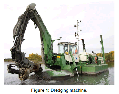
The existing technologies of dredging are based on excavation, bulldozer cleaning, suction and dredging with expensive serial equipment with pollution of coastal areas and, incredibly, large financial and material costs. Not every farm can afford such jobs (Figure 1).
The great Austrian hydraulic engineer Victor Schauberger once wrote that the rivers can be self-cleaned. Indeed, this is possible if the bottom of the rivers is formed in such a way as to give the flow of water a spiral motion. In fact, the natural movement of water in the river tends precisely to this form of flow - meandering - a gradual and continuous change in the river bed. In this case, rather large bends of the river are obtained, constantly increasing the total width of the floodplain. The consequence of the expansion is the collapse of the coast, the agricultural areas are being taken away, houses and buildings are being destroyed.
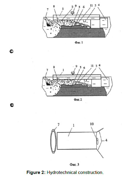
Developments have been developed that use the forces of the river to form the river bed and river bed, within specified limits, with given depths for passing ships, with straightening bends, and controlling water flow. However, there are opportunities to change meandering processes by the simplest means. Manufacture and operation of such facilities are available to small coastal farms that suffer from floods, collapse of shores, shallowing of fairways (Figure 2).
Work on the deepening of the rolls should be started during and immediately after the floods - with strong water movements to prevent floods next year. In the low period, in the summer, the effectiveness of such work is reduced because the water flows in the rivers decrease, and some rivers at this time completely dry up. The proposed method of influencing bottom sediments by the current itself is based on the constraint and control of part of the stream to influence bottom sediments. Devices do not constructively resist the flow of the river and do not require any energy at all. The technological process is carried out by directing a part of the stream to pre-selected places in the channel, creating erosion zones and depositing bottom sediments. Depending on the parameters of the river, the devices are controlled from the shore by cables or supplemented by known means of mobile movement. The new agent can stand firmly on the bottom and control the flow of water. A device to change the buoyancy and sail, ensure its free movement on the surface of the water. It is possible to supplement it with serial devices for any hydrotechnical works: search for and recovery of sunken objects, dredging, use of dredgers, cutting off surface and underwater branches and trunks of trees, washing and sorting bottom sediments, for example, for gold mining, raising a dewdrop and drowning objects. The properties of control and concentration of flows give absolutely new opportunities not only for the formation of the river bed, but also, for example, washing and classification of bottom sediments for mining. The impact on the bottom of a controlled current does not adversely affect the bottom fauna like dredging.
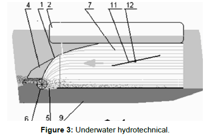
The recognized patent purity of a technical solution, the logical sequence of known essential features of technical solutions that are necessary, and all taken together, are sufficient for the given object to be operational. Tests of individual elements of micro models of the proposed device on small rivers have been carried out. Necessarily One can design and test work to check and show the effectiveness of the new method in field conditions. The first experience on a natural object can start a widespread deepening of the rifts on all rivers, where floods occur and warn them in the near future. The designs of such devices are developed for each type of water object. From small Kazakh rivers - Kaskelen, Kishi and Ulken Almaty, to the great rivers, such as the Irtysh, the Urals, the Mississippi and the Amazon. A similar problem occurs in the delta areas when river flows into the lakes and the sea. Gradual sedimentation of the channels and the delta duct raises their bottom, raising the water level. Shipping dies off, new channels appear, new areas are flooded and waterlogged, water is spent on impregnating sands and evaporation. All this ultimately leads to the fact that these lakes dry up, for example, the Aral Sea, on the turn of Balkhash. The proposed devices can save water from spreading and evaporation, if you remove the shoals in the main, historical channel, narrow the delta, restore shipping. To save water for the summer period, it is customary to build reservoirs based on dams and dams. Practice shows that abnormal precipitation leads to the breakthrough of such dams and floods. The reasons leading to this are also the long-term sedimentation of the reservoir itself by deposits from rivers. Periodically, it is necessary to clean the bowl of the reservoir from sediments. The proposed principle of cleaning the river bed with the proposed method can be applied here. The design with a propeller can be used in inverse mode to create a watercourse in slow-flowing rivers and even in stagnant water bodies. A device with a turned screw in the back is firmly positioned on the bottom, providing visibility in the development area. In essence, an absolutely new vehicle is proposed, moving along the bottom of the reservoir and performing hydrotechnical work. And if you supplement it with a caterpillar drive, it becomes an amphibian - a car going out on land (Figure 3).
Applications
a) Description of the patent
b) A summary of the catastrophic floods in Kazakhstan in the spring of 2017
Eurasian (21) (13) Patent Office (12) description of the invention to the eurasian application (43) Application Halidullin oleg khanyshevich (KZ).
Method of cleaning and deepening rusel riv from dependent deposits and equipment for its implementation
The invention relates to hydraulic engineering and can be used for cleaning river beds and canals from nano-owls. In the method for cleaning and deepening river beds from the bottom sediments by the eroding flow of water, which is created by a mobile water-resistant device with stream-guiding elements, the water flow is diluted by installing a water-resistant device with stream-guiding elements on the floating means, preferably at its bottom. In this case, a zone of erosion is formed under the bottom of the floating device. Floating means are moved along the channel at a rate that ensures erosion of bottom sediments. Before the clearing and deepening of the channel, the relief of the bottom sediments is determined beforehand. Undiluted part of the bottom sediments are destroyed by mechanical action of additional devices placed on the water-resistant device. The water-diffusive device with stream-guiding elements contains longitudinal ribs fixed mainly on the bottom part of the floating means, the flow control elements are made in the form of shields mounted on the end parts of longitudinal ribs with the possibility of adjusting the gap between them. The surface of the ribs, the bottom of the floating means, the surfaces of the streamrunning elements form a cavity above the surface of the bottom of the river. Cutters in the form of ploughshanks are made with the possibility of changing the direction of their edges. Cutters in the form of screws or rotors are equipped with drives. Drives of screws or rotors are made in the form of blades driven into the rotation by a stream of water.
Method for Preventing Flooding and River Water Flow Management during the Period of Flooding and the Device for its Implementation
The invention relates to hydrotechnical construction and can be used to prevent flooding and water flow management in the period of floods.
The technical result with the use of the proposed invention is to provide the possibility of erosion of the rolls with the passage capacity of the river for the movement of vessels along the paved fairway, while avoiding the formation of floods on the river. Measure the water levels in adjacent reaches with the location of the reefs, the eroding stream of water is directed to rolling, and the management of the river's water flows during the floods is provided by laying the fairway by moving the water - Devices along the river bed along the trajectory of the future fairway. The waterproof device is made in the form of rigidly connected parallels oriented vertical floating shields, and for the channeling of the fairway, additional flexible adjustable connections are added to the structure of the device, changing the location of the water-resistant device in the longitudinal and pseudo-transverse movement of the river's water flow. The method of clearing sediments and deepening river beds and the device for its implementation.
US patent, at the stage of registration number 870624. Device for underwater hydrotechnical works. Positive decision on the application No. 0835-1 dated September 19. 2016 ?.
Мпк Е02в 3/02 Е02в 15/00 Device for Underwater Hydrotechnical Works
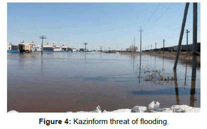
Inventions at the stage of developmental development. We offer cooperation to producers of dredging equipment, as well as to all interested parties. The flood situation in the North-Kazakhstan region remains alarming Photo by Tamara Vaal Tamara Vaal, Astana, Vlast Minister of the Interior Kalmukhanbet Kasymov said an alarming flood situation in the territory of the North Kazakhstan region. Because of the large overcrowding of the Sergeevsky reservoir, 170 houses were flooded in the suburbs of Petropavlovsk. "I would like to say from the flood situation that we have an alarming situation in Northern Kazakhstan. All the water that was Karaganda and Akmolinsk region came to Sergeevsky reservoir, and 138% more filled from the norm. There is an overflow and it fills all the settlements of the suburbs of Petropavlovsk and now about 170 houses are flooded there, "Kasymov said on Friday during a government hour in the Senate. Sputniknews. kz: The second wave of the second wave: the water continues to arrive in Petropavlovsk. The water in Petropavlovsk and its suburbs continues. To rise, flooded new houses. Sputniknews.kz ASTANA, May 5 – Sputnik: The second wave of floods came to Petropavlovsk: in the regional center and its suburbs the water continues to rise, new houses are flooded, deputy akim of the region Anton Fedyaev told journalists.2 hours ago. Zakon.kz: The heavy rain caused flooding in Almaty and the region on April 27 in Almaty and The region fell precipitation. A heavy downpour caused flooding, Zakon.kz correspondent reports. Nepogoda also caused flooding in the region. So, on the upper Kaskelen track flooded villas gardening society. According to local residents, a levee breakout allegedly occurred from above. This was the reason for leaving the banks of the Aksaika River. Water flooded the courtyards of houses, shops and other farm buildings. In some yards the water level reached 80 cm. 27.04.17: Tengrinews Drowned houses, drowned cars: almost half of the village in the SKU of the Kyzylzhar district of the North-Kazakhstan region went under water because of the flood, the emergency regime was declared. Half the houses are flooded in the suburban village of Teplichnoye. Residents. TengrinewsIn Kyzylzhar district of North-Kazakhstan region because of high water regime of emergency is declared. Half the houses are flooded in the suburban village of Teplichnoye. Residents are being evacuated. To save the remaining property, a mound is built between houses. Rescuers from Astana came to help the North-Kazakhstanis, Tengrinews.kz correspondent reports. Kazinform: The lists of residents living in the zone of possible flooding of Astana city are recorded. KAZINFORM: In connection with the increase in flood flow from the counter-regulator, there was a threat of flooding of urban areas along the coastline located in the area of the gas equipment plant and downstream, according to the official website of Astana (Figure 4). Kazinform: According to the resulting threat of flooding by the Department's staff, in close cooperation with local executive bodies, the local police service, the National Guard, measures were taken to undergo a bypass of objects falling into the zone of possible flooding, and handing out memos and notices.
Citation: Khalidullin OH (2017) Prevention of Floods. J Fisheries Livest Prod 5: 246. DOI: 10.4172/2332-2608.1000246
Copyright: © 2017 Khalidullin OH. This is an open-access article distributed under the terms of the Creative Commons Attribution License, which permits unrestricted use, distribution, and reproduction in any medium, provided the original author and source are credited.
Select your language of interest to view the total content in your interested language
Share This Article
Recommended Journals
Open Access Journals
Article Tools
Article Usage
- Total views: 8811
- [From(publication date): 0-2017 - Nov 22, 2025]
- Breakdown by view type
- HTML page views: 7774
- PDF downloads: 1037


