Palynological and Paleoenvironmental Investigation of Middle Miocene-Late Pliocene-Sediments from Well-X, Agbara Field between Intervals (2240 ft-3320 ft and 5260 ft-6160 ft), Shallow Offshore Depobelt, Niger Delta, Nigeria
Received: 02-Nov-2022 / Manuscript No. jescc-22-001-Pre Qc / Editor assigned: 04-Nov-2022 / PreQC No. jescc-22-001-Pre Qc (PQ) / Reviewed: 18-Nov-2022 / QC No. jescc-22-001-Pre Qc / Revised: 23-Nov-2022 / Manuscript No. jescc-22-001-Pre Qc (R) / Accepted Date: 23-Nov-2022 / Published Date: 30-Nov-2022 DOI: 10.4172/2157-7617.1000651
Abstract
Thirty-two (32) ditch cutting samples composited at 60 ft intervals from Well-X, shallow offshore Niger Delta were subjected to lithological and palynological analyses using the conventional maceration technique for recovering of acid insoluble organic- walled microfossils from sediments. The lithological analysis was done with the aid of the gamma ray log of the well sections and physical description. The samples consist of fine to medium grained shale and sandy shale suggesting that the analysed section belongs to the paralic Agbada Formation. A total of 183 (one hundred and eighty-three) palynomorphs consisting of 51 fungal spores, 23 pollens and 109 spores were obtained between 2240-3320 ft interval. A total of 64 species of palynomorphs were identified from 5260-6160 ft. The diagnostic palynomorphs recovered permitted the dating and paleoenvironmental interpretation of the section and included. Verrucatosporites usmensis, Selaginella sp, Laevigatosporites haaditii, Deltoidspora minor, Monoporites sp, Acrostichumaurem, pteris sp, Elaeis guineensis, Classopollis sp. Maximum abundance of palynomophs were encountered at depth range (2300-2360 ft), equal occurrence of pollen, spore, and fungal spores occur at (2660-2770 ft). A middle Miocene to Early Pliocene age was assigned to the studied section based on the co-occurrences of Stereisporites sp, Nympheapollis clarus, Cypereaopollis sp, Retistephanocolpites gracillis and Podocarpus milanjianus, and the absence of Gemmamonoporites sp. Palaeoenvironmental interpretation was conducted by grouping the palynomorphs recovered from the well section into their various paleoenvironmental groups. The results showsshow that the palynomorphs were dominated by fresh water and coastal swamp indicators with low occurrences of marine forms, suggesting deposition within the Delta plain to Delta front, within the foreshore to upper shoreface paleoenvironment.
Keywords: Palynology; Palynomorphs; Lithology; Paleoenvironmental; Niger Delta
Introduction
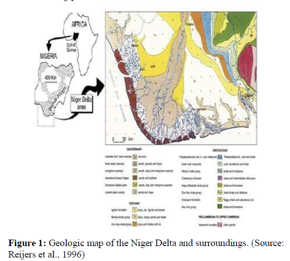
Well-X is located at the offshore Niger Delta Basin. The Niger Delta, figure 1 is ranked among the world’s most prolific petroleum produc- ing Tertiary deltas that together account for about 5% of the world’s oil and gas reserves and for about 2-5% of the present-day basin areas on Earth [1]. It is the most significant hydrocarbon province on the West African continental margin. It lies mainly in the Gulf of Guinea to the Southwest of the Benue-Trough and constitutes the most important Cenozoic deltaic construction in the South Atlantic. Numerous works have been undertaken on the Tertiary Niger Delta. Some of the pioneer workers on the geology of the Niger Delta [2,3], who first provided the initial information on the sediments and subsurface distribution of the stratigraphic units in the Niger Delta. Studied the outline of the Ni- ger Delta and suggested that the major source rocks were shales of the Agbada Formation. Some works have also been done by Avbovbo and Oyede on the environment of the Niger Delta [4,5]. Oyede based on palynofacies principles pioneered by Whitaker identified the following environments in the Niger Delta; mangrove swamp, channel deposits, shoreface and marine. Palynostratigraphic studies undertaken to date on the Niger Delta [6-17].
Clarke [18], identified Peregrinipollis nigericus, as a new sporomorph in the Upper Tertiary of Southern Nigeria subsequently; it has been ex- tensively used as middle Miocene marker in the Niger Delta. The most comprehensive palynological research to date was that carried out by Germeraad on some tertiary sediment from the world’s tropical areas. It is largely a comparative study of palynomorphs of Tertiary sediments from tropical South America, Asia and West Africa. Knaap [19] pro- vided a good time correlation across the continental deposits of the Be- nin Formation and the transitional sequence of the Agbada Formation and considered the sudden appearance of Podocarpus milanjianus, a montane conifer as a time marker.
Morley employed palynology in sequence stratigraphic study in the Neogene Niger Delta when he compared the palynological char- acterization of system tracts from the Niger Delta and Southeast Asia (India, Indonesia, and Malaysia). The study emphasized that in the Tertiary basins, application of palynology is principally in correlation rather than dating and concluded that the integration of data from both palynomorphs and marine microfossils (foraminifera, nannofossils) can provide a much better basis for system tracts interpretation than when used singly.
Evamy adopted an informal palynological zonation for the Niger delta using alpha numeric nomenclature. Legoux analyzed and used Praeda- pollis africanus, P. flexibilis, Verrutricolporites rotundiporus and other taxa for the zonation of some parts of the Neogene Niger Delta. Sowu- mi analyzed pollen grains of thirty-six meters deep cores from the Niger Delta and concluded from the report that in the Quaternary, there were shifts in the extent of rainforest and that the savannah had been reduced. Biffi and Grignani worked on dinoflagellate cysts assem- blage that penetrated Oligocene strata and they proposed seven new species belonging to the Lejeunecysta, two new species of the Phelo- dinium and one new species of the Selenopemphix.
The present study intends to use palynostratigraphic approach that utilizes terrestrially derived palynomorphs, in conjunction with the well log (gamma ray log) of the well section, to characterize the vari- ous lithostratigraphic units, decipher the paleoenvironment, and the age of the strata penetrated byin Well-X. The gamma ray log was used to distinguish the sedimentary components in terms of lithologies and paleoenvironments. It is envisaged that the result shall add to informa- tion on the miospores recoverable from the Niger Delta and assist in the ongoing refining of the zonal scheme for the Niger Delta.
Aim and Objectives of the Study
The aim of this work is to use palynomorphs generated from the study in conjunction with the gamma ray log of the well section to charac- terize the sediments and determine the age of the strata penetrated by Well X and the objectives are as follows:
• To document the palynomorphs contents based on the abun- dance, composition and diversity.
• To determine the age of the well section.
• Interpret the depositional environment of the sediments.
• Establish a lithostratigraphic sequence of the studied area.
Location and assessibility
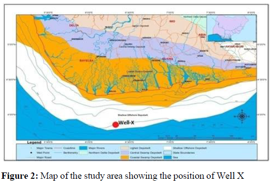
Well-X is located in the shallow offshore depobelt of the Niger Del- ta Basin figure 2. It is located at latitude 3051.52’N and longitude 6020.26’E. The red cycle on the map shows the exact position of the well. The Niger Delta is a low-lying plain consisting mainly of recent unconsolidated sediments of Quaternary age. These sediments are partly of marine and partly of fluvial origin. Land elevation is generally less than 50 meters above mean sea level and there is a marked absence of imposing hills that rise above the general land surface. The area traversed by numerous flat-floored rivers that drain into the Atlantic Ocean. The area is prone to flooding especially during the wet season, mainly because of the heavy rainfall, sea level rise and flat-floored val- leys and rise in groundwater table 1. This results in almost total sub- mergence during the wet season with exception of the natural levees.
| S/N | DEPTH(ft) | LITHOLOGIC DESCRIPTIONS |
|---|---|---|
| 1 | 2240 | Sandy shale, gray in colour, medium grained, slightly calcareous |
| 2 | 2300 | Sandy shale gray in colour, medium grained, slightly calcareous |
| 3 | 2360 | Sandy shale gray in colour, medium grained non calcareous |
| 4 | 2420 | Sandy shale gray in colour, medium grained, slightly calcareous |
| 5 | 2480 | Shale, grey in colour, fine grained non calcareous |
| 6 | 2540 | Shale, grey in colour, fine grained non calcareous |
| 7 | 2600 | Sandy shale gray in colour, medium grained, slightly calcareous |
| 8 | 2660 | Sandy shale gray in colour, medium grained, slightly calcareous |
| 9 | 2770 | Sandy shale gray in colour, medium grained, slightly calcareous |
| 10 | 2900 | Sandy shale gray in colour, medium grained, slightly calcareous |
| 11 | 2960 | Sandy shale gray in colour, medium grained, slightly calcareous |
| 12 | 3020 | Shale, grey in colour, fine grained slightly calcareous |
| 13 | 3080 | Shale, grey in colour, fine grained non calcareous |
| 14 | 3140 | Shale, grey in colour, fine grained slightly calcareous |
| 15 | 3200 | Shale, grey in colour, fine grained slightly calcareous |
| 16 | 3320 | Sandy shale gray in colour, medium grained, slightly calcareous |
Table 1: Lithologic description samples between interval 2240 -3320ft.
Geology of study area
The Niger Delta is situated in the Gulf of Guinea on the west coast of Central Africa. It is located in the southern part of Nigeria between latitudes 40 00’N and 50 300’N and longitudes 50 00’E and 80 00’E. It is bounded in the south by the Gulf of Guinea (or the 4000 m bathymet- ric contour) and in the North by older (Cretaceous) tectonic elements which include the Anambra Basin, Abakaliki uplift and the Afikpo syncline. In the east and west respectivily, the Cameroon volcanic line and the Dahomey Basin mark the bounds of the Delta. The Cenozoic Niger Delta is situated at the intersection of the Benue trough and the South Atlantic Ocean where a triple junction developed during the separation of South America from Africa.The Delta is consid- ered one of the most prolific hydrocarbon provinces in the world, and recent giant oil discoveries in the deep‐water areas suggest that this region will remain a focus of exploration activities.
Furthermore, the Niger Delta is one of the world’s largest deltas, with sub‐aerial acreage of about 75,000 km2. It is composed of an over- all regressive clastic sequence, which reaches a maximum thickness of 30,000 to 40,000 ft (9000 to 12000 m). Well sections through the Niger Delta generally display three vertical lithostratigraphic subdivi- sions: an upper delta top facies; a middle delta front lithofacies; and lower pro-delta lithofacies. These lithostratigraphic units corre- spond respectively with the Benin Formation (Oligocene-Recent), Ag- bada Formation (Eocene-Recent) and Akata Formation (Paleocene- Recent). The Akata Formation is composed mainly of marine shales, with sandy and silty beds which are thought to have been laid down as turbidites and continental slope channel fills. It is estimated that the formation is up to 7,000 metres thick. The Agbada Formation is the major petroleum-bearing unit in the Niger Delta. The formation consists mostly of shoreface and channel sands with minor shales in the upper part, and alternation of sands and shales in equal proportion in the lower part. The thickness of the formation is over 3,700 metres. The Benin Formation is about 280 metres thick, but may be up to 2,100 metres in the region of maximum subsidence and consists of continen- tal sands and gravels.
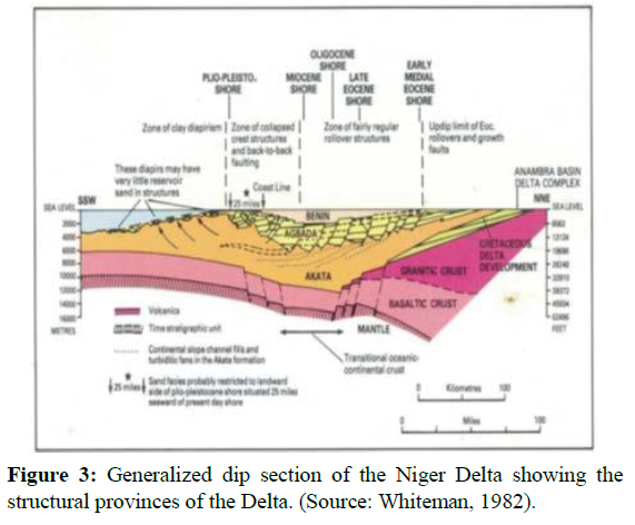
The Delta built out over the collapsed continental margin, and its core is located above the collapsed continental margin at the site of the triple junction formed during the middle Cretaceous. The main sediment supply has been provided by an extensive drainage system, which in its lower reaches follows two failed rift arms, the Benue and Bida basins. Sediment input generally has been continuous since the Late Cretaceous, but the regressive record has been interrupted by episodic transgressions, some of considerable extent. The Niger Delta has prograded into the Gulf of Guinea at a steadily increasing rate in response to the evolving drainage area, basement subsidence and eustatic sea level changes. Initially, the delta prograded over exten- sionally thinned and collapsed continental crust of the West African margin figure 3, as far as the triple junction, filling in the basement graben‐and‐horst topography. During the middle and late Eo- cene, sedimentary rocks became increasingly sandy, marking the onset of a general regression of the deltaic deposition.
Structural features in the Niger delta
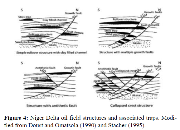
The Cenozoic Niger Delta complex is little disturbed at the surface but the subsurface is affected by large scale synsedimentary features such as growth faults, rollover anticlines and diapirs. Normal faults triggered by the movement of deep-seated, over-pressured, ductile, marine shale have deformed much of the Niger Delta clastic wedge (Doust and Omatsola, 1990). Many of these faults formed during delta progradation and were syndepositional, affecting sediment dispersal. Fault growth was also accompanied by slope instability along the con- tinental margin. Faults flatten with depth onto a master detachment plane near the top of the over-pressured marine shales at the base of the Niger Delta succession. Structural complexity in local areas reflects the density and style of faulting. Simple structures, such as flank and crestal folds, occur along individual faults. Hanging-wall rollover an- ticlines developed because of listric-fault geometry and differential loading of deltaic sediments above ductile shales. More complex struc- tures, cut by swarms of faults with varying amounts of thrown, include collapsed-crest features with domal shape and strongly opposing fault dips at depth figure 4.
Method of Study
Two types of data were used for this study and they are: electronic log (gamma ray log) and palynological data.
Lithologic Descriptions
At the laboratory a detailed lithologic description of the various samples were described. In doing this, the samples were crushed to increase its surface area and 2.0M of hydrochloric acid (HCL) was ap- plied on each sample to ascertain its level of effervescence. The degree of reaction of the samples with the acid was noted and expressed as calcareous, when there is effervescence and non-calcareous when there is no reaction with the acid. Also the rock types were delineated from the gamma ray log, and the colour, and texture of every sample were noted. The gamma ray log and the lithologic log of the well sec- tion from the gamma ray log, and colour, and texture of every sample were noted.
Palynological Sample Preparation
The non-acid palynological sample preparation technique using sodi- um hexametaphosphate was used to prepare the samples. This involves the following, the slides were studied under a palynological micro- scope and identification was attempted for as many forms as possible. This data obtained was used to prepare a distribution chart of palyno- morphs. Paleoenvironmental interpretation was done by calculating the percentage occurrence of the terrestrially derived palynomorphs (pollen/spores) and the marine forms (fungal spore, dinoflagellate cyst, microforaminiferal wall lining and achritarch) in the various depths. While age determination was done using the ages of the index forms.
Presentation of results and Discussion
Lithostratigraphy
The studied section “Well X” ranges from (2240-6160 ft) and (5260 – 6160 ft). A lithostratigraphic units penetrated by Well- X in the Niger Delta basin are described in Table 2.
| S/N | DEPTH(ft) | LITHOLOGIC DESCRIPTIONS |
|---|---|---|
| 1 | 5260 | Sandy shale, grey in colour, medium grained, non-calcareous |
| 2 | 5320 | Shale, fissile, grey in colour, non calcareous |
| 3 | 5380 | Shale, fissile, grey in colour, non calcareous |
| 4 | 5440 | Shale, fissile, grey in colour, non calcareous |
| 5 | 5500 | Shale, fissile, grey in colour, non calcareous |
| 6 | 5560 | Shale, fissile, grey in colour, non calcareous |
| 7 | 5620 | Shale, fissile, grey in colour, non calcareous |
| 8 | 5680 | Shale, fissile, grey in colour, non calcareous |
| 9 | 5740 | Shale, fissile, grey in colour, non calcareous |
| 10 | 5800 | Shale, fissile, grey in colour, non calcareous |
| 11 | 5860 | Shale, fissile, grey in colour, non calcareous |
| 12 | 5920 | Sandy shale, grey in colour, coarse grained, non-calcareous |
| 13 | 5980 | Sandy shale, grey in colour, coarse grained, non-calcareous |
| 14 | 6040 | Sandy shale, grey in colour, coarse grained, non-calcareous |
| 15 | 6100 | Sandy shale, grey in colour, coarse grained, non-calcareous |
| 16 | 6160 | Sandy shale, grey in colour, coarse grained, non-calcareous |
Table 2: lithologic description of well X.
Data Interpretation
The distribution of fossil assemblage in every stratigraphic section might be controlled by paleoecological factors Hamza et al. (2002). From the recovered palynomorphs during the analysis, it shows that Well X interval (2240 ft-3320 ft) is entirely composed of terrestrially derived palynomorphs (fungal spores, pollens and spores) indicat- ing that the environment of deposition was terrestrial. The age of the studied interval was delineated based on the ages of the various index forms found within the studied interval. The age of the studied in- terval, (2240-3320ft) was determined to be Middle Miocene because of the presence of age determinant form Pachyderimites diederixi. For the interval (5260-6160ft) from the analysis, the sediments was observed to have been deposited during Early-Late Pliocene times as evidenced by the co-occurrences of Stereisporites sp, Nymphea- pollis clarus, Cypereaopollis sp with Retistephanocolpites gracillis and Podocarpus milanjianus. The absence of Gemmamonoporites sp Whose top occurrence is dated 4.5Ma portrays that this interval is not as old as 4.5Ma further supporting this interpretation.
Paleoenvironment
The various palynomorphs were grouped into their various paleoeco- logical groups with a view to determining their paleoenvironment. The paleoenvironment of the Well X (interval 2240-3320 ft) was deduced to be within a Marginal marine environment
Discussion
Palynological and lithological study was carried out on 32 ditch cut- ting samples obtained from Well X between 2240 ft-3320ft and 5260- 6160 ft interval, in the shallow offshore depobelt of Niger Delta. The lithological study was done with the aid of the gamma ray log of the well section. This study aided the establishment of the lithostrati- graphic framework of the well section. The samples were entirely made up of sandy shale and shale suggesting that the analysed section is still within the parallic Agbada Formation. The samples were subjected to palynological analysis and the palynomorphs derived includes; Ver- rucatosporites usmensis, Selaginella sp, Laevigatosporites haaditii, Fungal spore, Fungal conidia, Deltoidspora minor, Monoporites sp, Acrostichumaurem, Pteris sp, Elaeis guineensis, Classopollis and sev- eral others. A palynomorph distribution chart was produced using the table showing the depth to depth assemblage distribution of palyno- morphs table and a percentage of palynomorphs per depth. The age of the studied interval was suggested using the palynological informa- tion obtained. Using the palynological information obtained from the samples. The age was determined to be Middle Miocene-Late Pliocene because of the presence of age determinant form Pachyderimites die- derixi for middle Miocene and the presence of Nympheapollis clarus, Retistephanocolpites gracillis and Podocarpus milanjianus suggesting Early to Late Pliocene. Paleoenvironmental interpretation was done by grouping the palynomorphs derived from the well section into their different paleoecological groups. A table
Conclusion
such as the terrestrial forms which includes: montane pollen, savanna pollen, mangrove pollen, spore, fungal spore, freshwater/forest, fresh- water algae, and the marine forms which includes; foram, dinoflagel- late, and acritarch. A table was established to show the percentage of every paleoenvironmental group per depth and from the table a plot showing the distribution of the different paleoenvironmental groups all through the well section was established. The plots shows that the palynomorphs were dominated by terrestrial forms in 2240-3320 ft but in 5260-6160f t freshwater algae (Botryccocus braunii) and mangrove pollen (Zonocostitites ramonae, Monoporites annulatus) which are coastal swamp indicators with low occurrence of marine forms (foram lining, dinocysts, Leiosphaeridia and diatom sp). Elements suggest- ing deposition within the Delta plain to Delta front setting (marshy swamp) within the foreshore to upper shoreface paleoenvironment.
Acknowledgments
None
Competing Interests
None
References
- Reijers TJA (1996) Selected chapters on geology: Sedimentary geology and sequence stratigraphy and three case studies and a field guide. She Petrol Dev.
- Short KC, Stauble AJ (1967) Outline of the geology of Niger delta. AAPG Bulletin 51: 761–779.
- Frankl EJ, Cordry EA (1967) The niger delta oil province: Recent developments onshore and offshore 7th World Petroleum Congr. Mexico City Proc 1:195-209.
- Avbovbo AA (1978) Tertiary lithostratigraphy of the Niger delta. AAPG Bulletin 62:295-306.
- Oyede AC (1992) Palynofacies in deltaic stratigraphy. Nig Assoc Pet Explo Bull 7:10-16.
- Van Hoeken-Klinkenberg PMJ (1964) A palynological inves- tigation of some upper cretaceous sediments in Nigeria. Pollen Spores 6: 209-231.
- Germeraad JH, Hopping CA, Muller J (1968) Palynology of ter- tiary sediments from tropical areas. Rev Pala Paly. 6:189-348.
- Evamy DDJ, Haremboure P, Kamerling WA, Knaap F, Molloy A et al. (1978) Hydrocarbon habitat of the Tertiary Niger Delta. AAPG Bulletin 62:1–39.
- Kogbe CA, Sowunmi B (1975) The age of the continental terminal as suggested by sporopollenitic analysis. Savana Ahmadu Bello Unive Zaria Nigeria 4:47-55.
- Legoux O (1978) Quelques especes de pollen caracteristiques de neogene du Nigeria. Bull Cent Rech Explor Prod Elf-Aquitanie 2: 265-317.
- Jan du chene RE, Salami MB (1978) Palynology and micropale- ontology of the upper eocene of the well Nsukwa-1 (Niger Delta, Nigeria) C.R. des Seantes SPHN Geneva 13:5-9.
- Jan du chene RE, Onyike MS, Sowunmi MA (1978) Some new eocene pollen of the ogwashi-asaba formation, south-eastern Ni- geria. Revista Espanola de Micropalontologia 10: 285-322.
- Biffi U, Grignani D (1983) Peridinoid dinoflagellates cysts from the Oligocene of the Niger delta. Nature Phys Sci 233:132-133.
- Morley R J, Richards K (1983) Graminae cuticle: A key indicator of late cenozoic climatic changes in the Niger delta. Rev Pala Paly 77:119-127.
- Poumot C (1989) Palynological evidence for eustatic events in the tropical neogene. Bull Cent Rech Explor Prod Elf-Aquitaine 13: 437-452.
- Oboh FE (1992) Middle miocene paleoenvironment of the Niger delta. Palae Palaeo Pala 92:55-84.
- Oboh FE, Salami MB, Chapman JL (1991) Palynological inter- pretation of the palaeoenvironments of miocene strata of the well igbomotoru-1, Niger Delta. Journ Micropal 11:1-6.
- Clarke RT (1996) Peregrinipollis nigericus - A new palynomorph from the upper tertiary of Nigeria. Grana Palynological 6:540-54.
- Knaap WA (1971) A montane pollen species from the upper ter- tiary of the Niger delta. Nig Journ Min Geol 6:23-39.
Indexed at, Google Scholar, Crossref
Indexed at, Google Scholar, Crossref
Indexed at, Google Scholar, Crossref
Indexed at, Google Scholar, Crossref
Indexed at, Google Scholar, Crossref
Indexed at, Google Scholar, Crossref
Indexed at, Google Scholar, Crossref
Indexed at, Google Scholar, Crossref
Indexed at, Google Scholar, Crossref
Indexed at, Google Scholar, Crossref
Indexed at, Google Schola, Crossref
Citation: Ononiwu S, Innocent D (2022) Palynological and Paleoenvironmental Investigation of Middle Miocene-Late Pliocene-Sediments from Well-X, Agbara Field between Intervals (2240 ft-3320 ft and 5260 ft-6160 ft ), Shallow Offshore Depobelt, Niger Delta, Nigeria. J Earth Sci Clim Change. 13:651. DOI: 10.4172/2157-7617.1000651
Copyright: © 2022 Ononiwu S, et al. This is an open-access article distributed under the terms of the Creative Commons Attribution License, which permits unrestricted use, distribution, and reproduction in any medium, provided the original author and source are credited.
Select your language of interest to view the total content in your interested language
Share This Article
Recommended Journals
Open Access Journals
Article Tools
Article Usage
- Total views: 1769
- [From(publication date): 0-2022 - Nov 06, 2025]
- Breakdown by view type
- HTML page views: 1328
- PDF downloads: 441


