Research Article Open Access
Morphology of the Niger Delta: Local Facies Belts Orientation versus Depobelts and Growth Fault Orientations
Durogbitan A Abimbola*
Petrfac IES, Research and Development, Manchester, UK
- *Corresponding Author:
- Durogbitan A Abimbola
Principal Geoscientist, Petrfac IES
Research and Development, Manchester, UK
Tel: +447545822428
E-mail: adewoledurogbitan@yahoo.co.uk
Received date: April 08, 2016; Accepted date: May 13, 2016; Published date: May 26, 2016
Citation: Durogbitan AA (2016) Morphology of the Niger Delta: Local Facies Belts Orientation versus Depobelts and Growth Fault Orientations. J Marine Sci Res Dev 6:190. doi:10.4172/2155-9910.1000190
Copyright: © 2016 Durogbitan AA. This is an open-access article distributed under the terms of the Creative Commons Attribution License, which permits unrestricted use, distribution, and reproduction in any medium, provided the original author and source are credited.
Visit for more related articles at Journal of Marine Science: Research & Development
Abstract
This work presents for the first time, evidence and the relationship between the ancient coastal belt and the modern coastal belt in terms of local facies belts orientation versus depobelt and fault orientations within the Niger Delta. This observation suggests that the ancient coastal belt of the delta is more lobate /arcuate than the modern Niger delta. The delta became broadly convex to the sea during the late Miocene. Deltas are influenced by a variety of fluvial and marine processes and these processes controlled their morphology. The most widely used classification scheme today is that of Galloway who subdivided delta according to their dominant processes i.e. rivers, waves and tide. Fluvially dominated deltas tend to display lobate-elongate morphology, e.g. the Balize delta- Mississippi. In contrast wave-dominated deltas tend to be more lobate and have smooth, arcuate to cuspate margins, e.g. the Nile delta. Tide dominated deltas tended to be estuarine to irregular in geometry. Although the Niger delta has been characterized to be mixed influenced delta showing the combination of the effects of river, wave and tidal processes, the modern Niger delta has been described to be more wave dominated and more lobate, and the classification falls within the wave dominated section on Galloway classifications. This implies that during Miocene, the delta was more fluvially dominated in relation to sediment supply and basinal processes (wave and tide). This also implies that the modern Niger delta cannot be used as a direct analogue for the ancient delta.
Keywords
Niger delta; Depobelts; Facies belts
Introduction
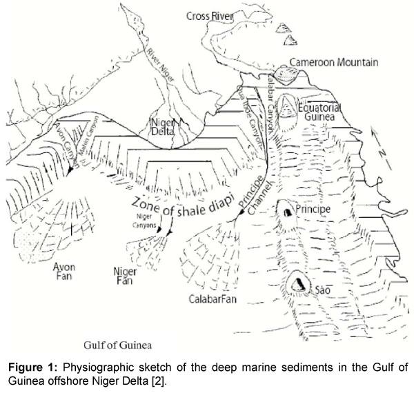
The morphology of the Niger Delta can be subdivided into an early stage, spanning the Paleocene to early Eocene, and a later stage of delta development beginning in Miocene time [1]. Early coastlines were concave to the sea and depositional patterns strongly influenced by basement topography [1]. Delta progradation has been assumed to occur along two major axes [2]. The first paralleled the Niger River, where sediments supply exceeded subsidence rate. The second which is smaller than the first became active basinward of the Cross River during the Eocene to Oligocene. Late stages of deposition said to have began in the early to middle Miocene, as these separate eastern and western depocentres merged. In the late Miocene the delta prograded and shorelines became broadly convex into the sea. Rapid sediment loading by this delta progradation mobilized underlying unstable shales (Akata Formation). These shales rose into diapiric walls, deforming overlying strata. The resulting complex deformation structures caused local uplift, which has resulted in major erosion events into the leading progradational edge of the Niger Delta [3] (Figure 1).
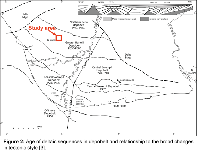
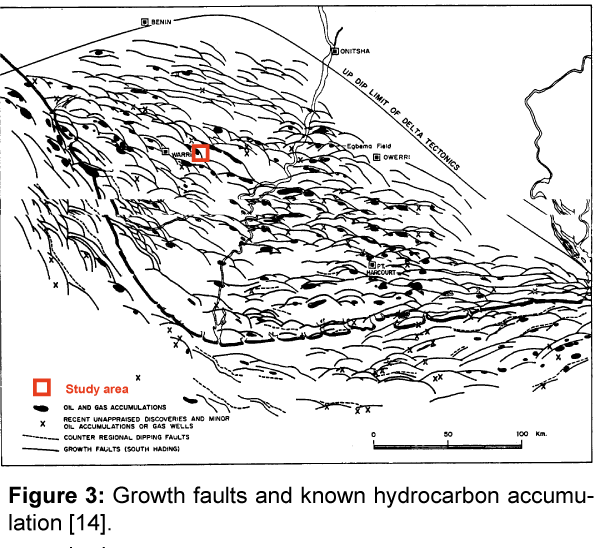
The Cenozoic Niger Delta complex has been described as an arcuate-lobate shape by many authors (e.g [3-5]). Structural analysis has identified a number of faults within the study area. The growth faults are listric in cross section and concave to the basin in plan-view. The Niger delta has been subdivided into seven mega units called depobelts [3]. Which are self-entities with respect to stratigraphy in which has been distinguished by their ages and are defined by sedimentary faults. These faults are also observed to be parallel to these regional depobelts and the present day facies belts (Figures 2 and 3).
Sesimic and Sequence Stratigraphy
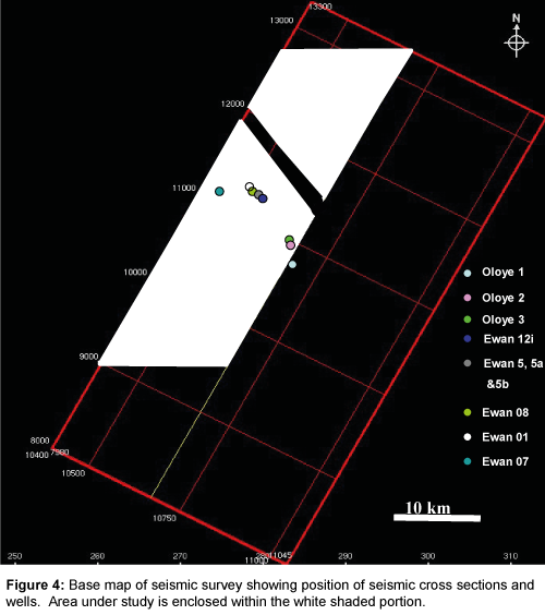
This section summarised a seismic and sequence stratigraphic framework (studied area) for a growth-faulted delta deposits of the Agbada Formation (Middle Miocene) within the Ewan and Oloye Fields, northwestern Niger delta, (Figure 4). The application of sequence stratigraphic methods to Niger Delta sequences is complex because the key surfaces, strata geometry or stacking patterns are difficult to identify. These complexes are due to changes in relative sea level which are strongly influenced by the interplay between shoreline advance and retreat, concomitant isostatic loading and rebound of the continental shelf growth faulting and basin physiography.
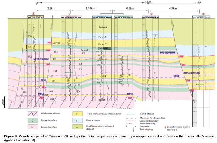
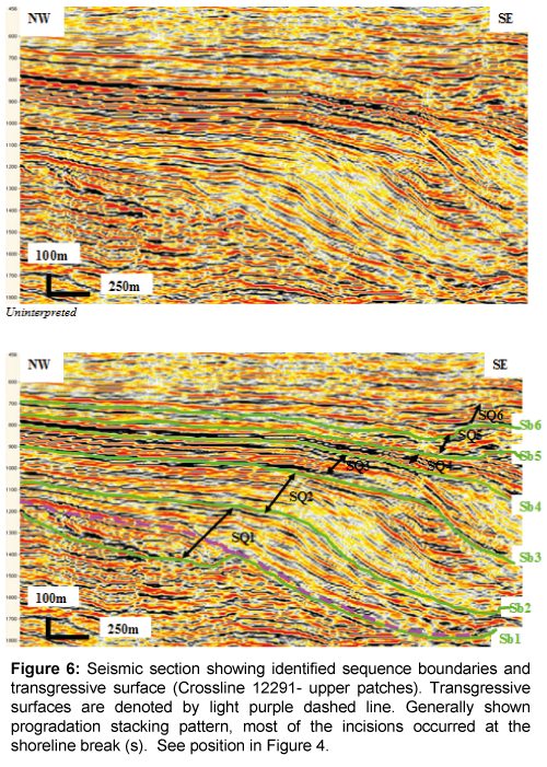
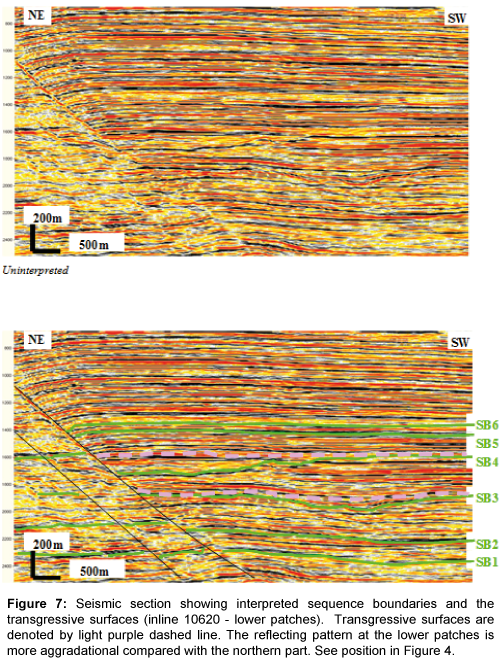
Detailed sequence stratigraphic analyses showed that the middle Miocene-early Pliocene strata in the Ewan and Oloye fields of the northwestern Niger delta consist of six depositional sequences [6] (Figures 5-8). In general, sequences are widespread. They are made up of progradational HST, TST are thin but widespread, and LST are restricted to within valley fills. Outside the LST valleys, transgressive surfaces and sequence boundaries are coincident on interfluves. This suggests that during LST times most of the area was periodically subaerially exposed. During lowstand period, shorelines and facies belts prograde basinward (south) and there are development of canyons which serve as a conduit for high amplitude deposit (deep water sand) on the slope and within the basin floor [6,7]. This mechanism is interpreted to have led to the deposition of considerable amount of sandstones basinward (E, F, G;[6]).
Figure 6: Seismic section showing identified sequence boundaries and transgressive surface (Crossline 12291- upper patches). Transgressive surfaces are denoted by light purple dashed line. Generally shown progradation stacking pattern, most of the incisions occurred at the shoreline break (s). See position in Figure 4.
Figure 7: Seismic section showing interpreted sequence boundaries and the transgressive surfaces (inline 10620 - lower patches). Transgressive surfaces are denoted by light purple dashed line. The reflecting pattern at the lower patches is more aggradational compared with the northern part. See position in Figure 4.
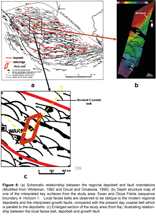
Figure 8: (a) Schematic relationship between the regional depobelt and fault orientations (Modified from Whiteman, 1982 and Doust and Omatsola, 1990). (b) Depth structure map of one of the interpreted key surfaces from the study area- Ewan and Oloye Fields (sequence boundary 4- Horizon 1. Local facies belts are observed to be oblique to the modern regional depobelts and the interpreted growth faults, compared with the present day coastal belt which is parallel to the depobelts. (c) Enlarged section of the study area (from 8a), illustrating relationship between the local facies belt, depobelt and growth fault.
Individual sequences have been mapped across the study area and biostratigraphic data has allowed a correlation with regional biozonal ages for the Niger delta complex [6]. However, there is strong local growth fault control on sequence variability. Further local controls on sequence geometry are shelf instability and slope collapse structures which have a strong geomorphological impact on the area [6]. The slope scars act as a locus for lowstand incision and affect overall sequence thickness. The incisions are narrower and deeper in lower sequences whereas those at the higher sequences are broader and less deeply incised. The additional accommodation space above slope scars allows local development of thick HST with seismically resolvable clinoforms. The occurrence of the several incisions in the middle Miocene succession is interpreted as evidence of significant relative sea level fluctuations, and the presence of type-1 sequence boundaries may be the stratigraphic signature of major drops in relative sea level during Miocene and Pliocene.
By and large, sequences that developed within the study area are seen to be controlled locally by episodic shelf instabilility and fault growth, with relative sea level providing major controls on sequence development and deep channel incisions [6].
Discussion
Structural and seismic facies analysis of the study area shows that the local facies belts have a different orientation in relation to the growth faults, and the depobelts mapped using the high resolution 3D seismic integrated with available well data, clearly do not mirror the present day orientation. From this detailed study, local facies belts are observed to be oblique to the modern regional depobelts and the interpreted growth faults, compared with the present day coastal belt which is parallel to the depobelts.
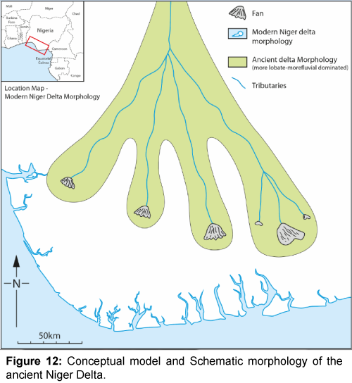
This work presents for the first time, evidence and the relationship between the ancient coastal belt and the modern coastal belt in terms of local facies belts orientation versus depobelt and fault orientations within the Niger Delta. This observation suggests that the ancient coastal belt of the delta is more lobate /arcuate than the modern Niger delta. The delta became broadly convex to the sea during the late Miocene.
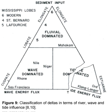
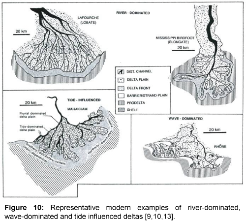
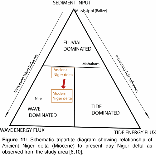
Deltas are influenced by a variety of fluvial and marine processes and these processes controlled their morphology [8-10]. The most widely used classification scheme today is that of Galloway [8], who subdivided delta according to their dominant processes i.e. rivers, waves and tide (Figure 9). Fluvially dominated deltas tend to display lobate-elongate morphology, e.g. the Balize delta- Mississippi. In contrast wave-dominated deltas tend to be more lobate and have smooth, arcuate to cuspate margins, e.g. the Nile delta. Tide dominated deltas tended to be estuarine to irregular in geometry [8] (Figure 10). Although the Niger delta has been characterized to be mixed influenced delta showing the combination of the effects of river, wave and tidal processes [3,11,12]. The modern Niger delta has been described to be more wave dominated and more lobate [1], and the classification falls within the wave dominated section on Galloway classifications. This implies that during Miocene, the delta was more fluvially dominated in relation to sediment supply and basinal processes (wave and tide) (Figure 11). This also implies that the modern Niger delta cannot be used as a direct analogue for the ancient delta [13,14] (Figure 12).
Conclusion
In summary, sesimic, sequence stratigraphic and depositional models developed for the Ewan and Oloye fields, enable detailed facies correlation on the field scale, and offer predictive models that can be used on a regional scale
The implication of this interpretation is that the modern Niger delta cannot be used as a direct analogue for the ancient delta (from the point view of sedimentary process). The data from the study area suggests that the ancient delta was more lobate with more complex facies distribution, and the delta was more fluvially influenced, wave dominated in relation to sediment supply and basinal processes fluvial input. It can be inferred and interpreted from the study that the ancient delta is characterized by lowstand shelf edge while the present day modern delta are of high stand shelf edge, because there was a believed that relative sea level over 20,000 yrs ago was at high stand. This defined major difference between the present day delta and the ancient delta in term of shelf edge location.
References
- Doust HE, Omatsola (1989) Niger Delta: American Association of Petroleum Geologists Memoir 48: 210-238.
- Reijers TJA, Petters SW, Nwajide CS (1997) The Niger delta basin in RC Selley, African basins-sedimentary basins of the world, Amsterdam, Elsevier Science pp: 151-172.
- Doust HE, Omatsola (1990) Niger delta in Edwards JD and Santogrossi PA divergent/passive margin basin AAPG 48: 201-238.
- Weber KJ, Daukoru EM (1975) Petroleum Geology of the Niger Delta. Proc. Ninth World Petrol. Congress 2: 209-221.
- Evamy BD, Haremboure J, Kimberling P, Knapp WA, Molloy FA, et al. (1978) Hydrocarbon habitat of tertiary Niger delta. AAPG Bull 62: 1-39.
- Durogbitan AA (2010) Seismic, sequence stratigraphic and structural analysis of Ewan and Oloye fields, Northwestern Niger Delta. Earth Science Department, University of Manchester pp: 337.
- Durogbitan AA, Gawthorpe RL, Redfern J (2008) Seismic straigraphy and development of deep fluvial incisions in the middle miocene deposits, Ewan and Oloye Fields, Northwestern Niger Delta. Proceeding of NAPE Annual Convention and Exhibition.
- Galloway WE (1975) Process framework for describing the morphologic and stratigraphic evolution of deltaic depositional systems. In Broussard ML, Deltas, models for exploration: Houston, TX, Houston Geological Society pp: 87-98.
- Bhattacharya JP, Walker GR (1992) Deltas. In: Walker GR and James PN. Facies models: response to sea level change. Geological Assoc of Canada pp: 157-177.
- Walker RG (1992) Facies models and modern stratigraphic concepts. In Walker RG and James NP, Facies Models: Response to seal level changes. Geological Assoc of Canada, pp: 1-14.
- Allen JRL (1965) Late quaternary Niger delta and adjacent areas- sedimentary environments and lithofacies: AAPG Bull 49: 547-600.
- Allen JRL (1970) Sediments of the modern Niger delta: a summary and review. In: Morgan JP, Deltaic sedimentation, modern and ancient. SEPM Spec Publ 15: 138-151.
- Fishers WL, Brown LF, Scott AJ, McGowen JH (1969) Delta system in the exploration for oil and gas, a research colloquium, Austin, TX, Texas Bureau of Economic Geology p : 204.
- Whiteman AJ (1982) Nigeria: Its petroleum geology, resources and potential. London, Graham & Totman 1: 166.
Relevant Topics
- Algal Blooms
- Blue Carbon Sequestration
- Brackish Water
- Catfish
- Coral Bleaching
- Coral Reefs
- Deep Sea Fish
- Deep Sea Mining
- Ichthyoplankton
- Mangrove Ecosystem
- Marine Engineering
- Marine Fisheries
- Marine Mammal Research
- Marine Microbiome Analysis
- Marine Pollution
- Marine Reptiles
- Marine Science
- Ocean Currents
- Photoendosymbiosis
- Reef Biology
- Sea Food
- Sea Grass
- Sea Transportation
- Seaweed
Recommended Journals
Article Tools
Article Usage
- Total views: 15591
- [From(publication date):
June-2016 - Jul 04, 2025] - Breakdown by view type
- HTML page views : 14385
- PDF downloads : 1206

