Research Article Open Access
Linking Spatialized Indicators of Desertification Risks with Observed Land Use/Land Cover Change: An Operational Monitoring System of Desertification
| Fetoui M1*, Loireau M2, Essifi B1, Chouikhi F1, Tarhouni M1, Sghaier M1, Laques AE2 and Dérioz P2 | |
| 1Institute of Arid Regions, Medinine, Tunisia | |
| 2Institute of Research and Development, UMR 228 SPACE-DEV, House of Remote Sensing IRD pole, 500, rue JF Breton, Montpellier cedex 05, France | |
| Corresponding Author : | Fetoui M Institute of Arid Regions Medinine, Tunisia Tel: (+216) 98 280 844 E-mail: mondher_ga@yahoo.fr |
| Received January 07, 2015; Accepted January 19, 2015; Published January 29, 2015 | |
| Citation: Fetoui M, Loireau M, Essifi B, Chouikhi F, Tarhouni M, et al. (2015) Linking Spatialized Indicators of Desertification Risks with Observed Land Use/ Land Cover Change: An Operational Monitoring System of Desertification. J Earth Sci Clim Change 6:252. doi: 10.4172/2157-7617.1000252 | |
| Copyright: © 2015 Fetoui M, et al. This is an open-access article distributed under the terms of the Creative Commons Attribution License, which permits unrestricted use, distribution, and reproduction in any medium, provided the original author and source are credited. | |
Visit for more related articles at Journal of Earth Science & Climatic Change
Abstract
The need of useful information for decision-makers to fight against desertification in Tunisian dry zones leads to conceive assessing and monitoring systems that can supply synthetic indicators. These latter should integrate socioeconomic and environmental dimensions with their spatial and temporal diversity at the local scale. This paper proposes an example of information system entitled SIELO (information system for operational desertification monitoring at the local scale). This system attempts to create the link between i) spatialized indicators of desertification risks, built in connection with the systematic complexity of desertification and ii) observed Land Use/ Land Cover (LU/LC) Change. The first type of data arises from pre-existing environmental model: LEIS model (Local Environmental Information System). The second type of data is extracted from satellite images acquired according to regular time steps. The proposed approach is based also on the spatializing of knowledge, via the ‘‘landscape’’ tool in particular. We illustrate the feasibility and the operational effectiveness of a developed software prototype (SIELO v1.0) with an initial application in a Tunisian dry zone. This system showed that it has the capacity to feed an operational monitoring of desertification according to the state of LU/LC directly observed or measured in several dates. Then, it can be useful for the decision-makers in their programs of fighting against desertification, but also to manage uncertainties in southeastern Tunisia, especially climate variability and climate change.
| Keywords |
| Desertification risks; Land use/Land cover change; Operational monitoring system; Decision support; Tunisian arid zones |
| Introduction |
| In order to provide useful information to decision-makers to better fight against desertification, research has to design operational desertification monitoring systems that take on account the complexity of Human-Environment systems, and supply synthetic desertification risk indicators related directly to observed LU/LC Changes. |
| Nowadays, the indicators used are generally status indicators [1] directly measurable or observed on the field or from a satellite image. They give a status of the system, without spatial and temporal correlation with factors that explain this status at the local scale [2]. Some methods are universally recognized such as the land cover classification system (LCCS) (Squires, 2010). These methods use generally indexes extracted from satellite images like the RUE method (rainfall use efficiency) to qualify the water resources, or the NDVI (normalized difference vegetation index) or NPP (Net Primary Productivity) to qualify vegetation. In arid regions, these methods are not well adapted to local scales as the example of the NDVI which badly distinguishes vegetations with weak cover [3]. |
| Advances are made at the regional and global scale, for example the Global Drylands Observing System (GDOS) proposed by Verstraete et al. [4], which relies between the status indicators adapted to the monitoring by remote sensing and the process of desertification. This kind of tools, or information systems [5], deal generally with the effects of the pastoral pressure [6] or of climate change [7]. Other tools mobilize the multi-agent systems that allow to better take into account the interactions between human actors [8], or even to measure the impact of public policies [9]. However, these tools have great difficulty in integrating spatial dimension of phenomena. When they generate spatial information via synthetic indicators of desertification risk, for example, we talk about Integrated Assessment Models (IAMs) [10]. |
| In fact, the political and scientific international community mobilizes within the framework of international convention of desertification (UNCCD). In preparation for the Conference of Parts (COP 10) held in October 2011 in Korea, the scientific and technical committee (CST), attached to UNCCD, has selected two impact indicators related to fighting against desertification: 1) the state of land (land cover status) and 2) the part of population living above poverty line. For the first indicator, the UNCCD and its college of scientific experts do not recommend yet a specific method among all those which exist, to establish the link between “Land cover or Land use” and “desertification”. The cartography of the "land cover change" that establishes a link with desertification, particularly on regional scales, rarely implement methods of calibrations/validations, which remain difficult and costly [11]. If they exist, they establish a relationship with a measure of degradation as a result of process but not with a complex system producer of degradation. Without knowledge of the causes, managers will not be able to make choices in their actions to fight desertification. |
| Indeed, the change of land cover and/or land uses, can be put in relation with the process of desertification. Once this relation is established, the LU/LC change can pass from a status variable to an indicator. |
| In our study region, the natural resources are being degraded by competition among LU/LC (especially the expansion of cropland at the expense of the natural rangelands) for a limited stock of natural resources. The changes in LU/LC lead generally to unsustainable ecosystem and make it more difficult to meet long-term basic human needs [12,13]. |
| Therefore, quantification and identification of LU/LC changes and theirs impacts on natural resources and the whole system vulnerability are urgently required before irreversible losses occur. Furthermore, there is a lack of information as to past and current environmental issues after the progressive LU/LC changes carried out in our region since minimum seventy years. This constituted our motivation to carry out the present research on the environmental assessing and monitoring of LU/LC changes, especially on natural resources vulnerability at the local scale. |
| The present research is then a contribution to meet the need to conceive methods and tools able to produce spatialized indicators which take in account the systemic and complex character of the desertification, the diversity of its local variations and the observed LU/ LC changes. These indicators must be easy to update in order to better assess and monitor desertification and to better support decision. |
| In this article, we propose an approach and a tool entitled "information system for the operational monitoring of desertification at the local scale" (SIELO) which help to identify this link between LU/LC changes and desertification risks. This proposal is based on a method which can link a pre-existing environmental modeling called LEIS “Local Environmental Information System” [14,15] with observed LU/ LC Changes in arid areas, in order to create an operational monitoring of desertification. The proposal is illustrated by a first application to an arid zone Tunisian. |
| Materials and Methods |
| Study site |
| Oum Zessar Watershed, occupied by around 24,000 inhabitants, is located in south-east of Tunisia in Medenine governorate with 36,000 ha surface area (Figure 1). This site is part of the Jeffara of Tunisia that presents a lower arid Mediterranean climate and a 160 to 220 mm average rainfall per year with an average of 30 days of rain. Water resources are a major constraint for pastoral (sheep and goats) and agricultural (cereals and tree cultivation) activities. This site is a typical agro-pastoral interlocked area with the gradual and in some areas accelerated expansion of cropland at the expense of the natural rangelands. In fact it has very significant eco-environment vulnerability, degraded vegetation in rangelands, intensification of agricultural use in plain areas which have led to water resources overuse and to land degradation [16]. This region has been a target area of the main national strategies for natural resource and combating desertification (water and soil conservation, water resources, pasture and rangelands, sand encroachment, rural development). |
| Main desertification issues are anthropic pressure having markedly increased in recent years due to changes in socio-economic policies. The effect of this has been an increasingly irrational use of natural resources, and as a consequence a state of severe degradation: i) Accelerated expansion of rainfed agricultural (especially olive tree and annual crops, cereals, etc. and irrigation system, ii) Significant change of agrarian system and land use, and iii) Development of multi sectors activities for income generation (urbanization, services, migration etc.). |
| Methodology and used tools |
| Our methodology correlates the types and levels of LU/LC changes which can be detected by remote sensing and the desertification risks determined by the spatial integrated model (LEIS). In fact, this approach integrates different kinds of spatial analyzes: landscape approaches, remote sensing and environmental modeling. This spatial integrated approach can produce and link i) a functional zoning or landscape typology from a field analysis, knowing that landscape analyses over long periods are essential for identification of unsustainable trends [17] and can be very helpful to decision-makers [18-20]; ii) an assessment of desertification risks from a spatial modeling of resources/uses (LEIS); and iii) a mapping of LU/LC dynamics from an analysis of a series of satellite images. |
| The information produced in this chain of treatments is integrated into an information system conceptualized: SIELO" Operational monitoring system of desertification”. This system can produce normalized indicators, which can be followed by remote sensing of the "LU/LC change". |
| The first step is to construct a landscape typology, serving for an operational decision making in terms of spatial planning, management of resources and fighting against desertification. |
| The second step is to characterize a potential risk of desertification evaluated according to an integrative approach of biophysical and socio-economic dynamics in each type of landscape. We use for that the LEIS model [15,21]. Each type of landscape can be characterized by an average index of risk of desertification (average weighted by the surface), either by level of risk (for example: low to medium risk, high risk and very high risk). |
| The third step is to simulate, with the LEIS model, the risk related to each potential type and amount of LU/LC changes, in each type of landscape. So, by applying several scenarios, we can assign to each class and proportion of LU/LC potential change, a "score" of level of high risks (RFTF), called standardized value of desertification risk (NRD) by type of LU/LC change. This score is standard and specific for each territory or case of study. |
| Then (step 4), we can calculate the real amount (surface) of different types of LU/LC changes with a supervised classification of a series of satellite images covering a period of interest (a specified period which interests the scientist and/or the managers) for each type of landscape. |
| The link can be then established between the assigned standardized values of risk and the real LU/LC changes detected by satellite images. We are talking about specific index of desertification (ISD) by type of change of land use in each type of landscape (step 5). |
| We can determine also the levels of desertification risks (IGDp) for all types of LU/LC changes by landscape type (step 6). The IGDp are calculated using the following formula: |
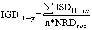 |
| y: Number of landscape types |
| n: Number of LU/LC change types |
| NRDmax: Maximal value assigned to different levels of desertification risks (NRD) by type of LU/LC change |
| We can also calculate new IGD by applying relevant scenarios of LU/LC changes which can occur on a given territory, corresponding to new land use strategies and policies (step 7). This information can be useful to policy makers. |
| Figure 2 summarizes the steps of the presented approach and constitutes the conceptual framework. This approach is based on the valorization of the materiality of the landscape (step 1), the prospective capacity of the LEIS model (steps 2 and 3) and the capacity of spatialization of LU/LC dynamics via the remote sensing (step 4) to produce indices of desertification risks (steps 5, 6 and 7). |
| On the basis of this conceptual framework, a prototype software “SIELO 1.0” has been developed in Visual Basic language 6, in the form of nested modules. SIELO uses and maintains a database on Access as the execution of the processing chain. The technical specification and the steps of the modeling are described in details in Fetoui (2011). |
| Figure 3 shows the interface of this prototype software. The idea to develop prototype software SIELO had the ambition to demonstrate its interest from researchers and development actors, to show them that they could take over all this tool, which is inexpensive and easy to manipulate, to support decision making. For this version, the results are in the form of tables that can be exported to Excel, and in form of histograms for the ISD, the IGD and the scenarios. |
| Results and Discussion |
| We have been able to test the SIELO approach and its implementation in the prototype software in the Tunisian arid zones, from data collected on the study site of Oum Zessar watershed. |
| - Landscape typology |
| It is based on the expertise and participation of resource persons (the heads of villages), researchers from different disciplines (ecology, geography, agronomy, geology etc.), and technical decision makers (agents of regional stations of agricultural development: CRDA). On the basis of meetings, investigations and transects in the field, the work led to the identification, delimitation and the validation of seven landscape types. The desertification risk is determined for each landscape type by applying LEIS model (Figure 4). |
| - Calculation of Normalized Risks of Desertification (NRD) specific to this area of study |
| The desertification risk indexes have been determined by applying the scenarios corresponding to the different potential types of LU/ LC changes. We considered three classes of changes of resources production following the LU/LC changes: 0-40%, 40-80% and >80%. |
| - Identification of LU/LC changes by remote sensing |
| We have treated Landsat images of 30 m resolution covering the period 2002-2007, to identify and quantify the major LU/LC changes. These changes correspond to flows of vegetal resources available in the catchment area, which are calculated and recorded in order to reinvest in the next steps of the modeling to calculate desertification risks. |
| - The layers of information elaborated from remote sensing (proportions of LU/LC changes) and first results of LEIS modeling (NRD), were then integrated in SIELO software v1.0 to calculate the specific indexes of desertification (ISD) corresponding to each type of LU/LC change. The results are automatically displayed in the form of histograms (Figure 5). They show that the types of LU/LC change n°4 (steppes-crops) and n°8 (crops-fallow) displayed a maximum risk of desertification compared with the other LU/LC change types. It is therefore a constant whatever the type of landscape, and a first meaningful and useful result. |
| However, the first results also show differences between landscapes. It is important to know these differences in order to adapt actions for combating desertification. For example, land use change n°10 (fallowcrops) displays different levels of risk, from a landscape to another, depending on specific biophysical (soils, geomorphology, vegetation, climate) and socioeconomic characteristics (population, income, needs, accessibility, type of operators, type of use). |
| The first product of SIELO (ISD) may therefore show what type of LU/LC change is responsible for the maximum risk of desertification in each type of landscape. It also allows to show why this type of change is responsible for this maximum risk. It can thus provide elements and feed the understanding of the causes and processes of desertification to orient and adapt the actions of combating desertification. |
| - The software calculates also the global indexes of desertification by type of landscape (IGDp) and the global index of desertification IGD for the whole study zone on the basis of standardized values (NRD) and the ISD calculated. For the study zone, the model gives an IGD of an average value of 0.59 (medium to high risk), knowing that this IGD has a spatial variability between 0.33 and 1. |
| The histogram of the IGD by type of landscape (Figure 6) shows that the landscapes 2, 5 and 7 display the greatest risks of desertification following the different land use changes registered between 2002 and 2007 (all changes are included). This synthetic information can lead actors to locate and to quickly assess the areas on which they should prioritize their actions. In fact, the high to very high risks of desertification are manifested, respectively, on 82%, 58 % and 73 % of the total area of landscapes 2, 5 and 7. In these landscapes, the lands are subjected to pressure because of the fragility of the soil and of the substantial population growth, especially in the landscape 2. The degradation in these types of landscape is manifested by regressive erosion [20]. |
| For the scenario which is to implement all developing actions already scheduled between 2010 and 2029, the results (Figure 7) show that the risks of desertification in the landscape 7 will increase, unlike the landscapes 5 and 6. In fact, in the landscape 7, particularly due to the clearing of many hundreds of hectares of sloping land, the areas which are subjected to low-medium pressure can easily switch to high-very high risks. This is because of the cumulative effect of the weaknesses of the socio-economic and biophysical potential (migration, family needs for agricultural products are less and less satisfied, poor and fragile soils, erosion, etc.). |
| Some landscape types have not been the subject of programming of actions by the actors, whereas the risk continues to worsen as the case of the landscape 6, in which the level of artificialization is very high (high population density, high animal charge, etc.). This new index therefore provides an additional information in relation to the others (NRD, ISD, IGDp) in terms of dynamic and sensitivity to planned actions. The same action in different local contexts has not the same results in terms of success or failure. These first results, exploratory in nature, were designed to make the demonstration of the interest of the approach. They have been discussed with the managers. These latter are very interested. They have themselves proposed several avenues for improvements. |
| Conclusion |
| The first results of this research are specially intended to the design and the learning of a "normalization" method of desertification risks through the observation of LU/LC changes, in order to support decision to better combat desertification. The demonstration made in the study site highlights the potential of SIELO tool to support the management of affected territories, by one of desertification indicators advocated by UNCCD. |
| On the basis of a spatial and integrated approach, the present research tried to link LU/LC changes to processes and risks of desertification. It allows the elaboration of standardized values of desertification which are easy to calculate and specific to each observatory or case study. |
| This research provides a continuous monitoring of desertification which could be in support to the existing observatories, in which it is difficult to provide information in near real time. If these observatories are capable to model and assess the risk of desertification at a time t0, and can acquire a continuous stream of satellite images, then it is possible to imagine that SIELO can take the relay for a monitoring of desertification. |
| This continuous monitoring could highlight major LU/LC changes and their corresponding desertification risks. It would be likely to alert in the short term the actors concerned by desertification and to orient immediately their actions, but also to manage uncertainties in southeastern Tunisia, especially climate variability and climate change. |
| We insist on the problem of credibility of the models and the impact of using their results regarding the success and effectiveness of applying measures and strategies to fight against desertification. Some of these uncertainties are already recorded and considered in the application of SIELO to our study site. |
| In terms of prospects, researches will be able to continue 1) in the study site, to improve the set of input data and the analysis of the desertification risks, and 2) in other socio-economic and biophysical contexts of arid zones, to improve the generality of the model. |
| Acknowledgements |
| SIELO is the result of a close collaboration between the Institute of Arid Regions (IRA) and the Research Institute for Development (UMR SPACE-DEV - IRD). It is a major result of the thesis of Mondher Fetoui [21]. |
References
|
Figures at a glance
 |
 |
 |
 |
| Figure 1 | Figure 2 | Figure 3 | Figure 4 |
 |
 |
 |
| Figure 5 | Figure 6 | Figure 7 |
Relevant Topics
- Atmosphere
- Atmospheric Chemistry
- Atmospheric inversions
- Biosphere
- Chemical Oceanography
- Climate Modeling
- Crystallography
- Disaster Science
- Earth Science
- Ecology
- Environmental Degradation
- Gemology
- Geochemistry
- Geochronology
- Geomicrobiology
- Geomorphology
- Geosciences
- Geostatistics
- Glaciology
- Microplastic Pollution
- Mineralogy
- Soil Erosion and Land Degradation
Recommended Journals
Article Tools
Article Usage
- Total views: 13688
- [From(publication date):
January-2015 - Apr 03, 2025] - Breakdown by view type
- HTML page views : 9156
- PDF downloads : 4532