Landslide Study of Gaj Watershed, Beas River Basin, Himachal Pradesh, India
Received: 23-Jul-2018 / Accepted Date: 14-Aug-2018 / Published Date: 20-Aug-2018 DOI: 10.4172/2157-7617.1000487
Keywords: Geology; Tectonics; Landslides; Degradation; Erosion
Introduction
Slope failures are commonly encountered in the hilly terrains of Himachal Himalaya. Theses hazards not only threaten various aspects of modern civilization i.e., buildings, roads and agricultural activities but also imbalance the natural equilibrium of ecosystem. These frequent natural as well as human induced hazards cause a great loss to life and property every year in the hilly terrains. A proper landslide zonation mapping, marking of week zones and areas vulnerable to slope failures, evaluation of suspected effects of these landslides and scientific preparedness and mitigation measures are needed to timely safeguard the areas against destruction caused by them.
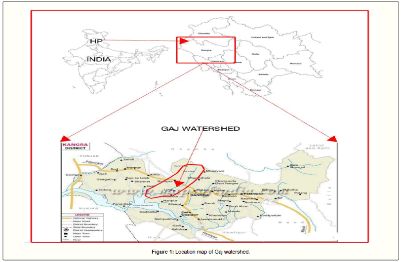
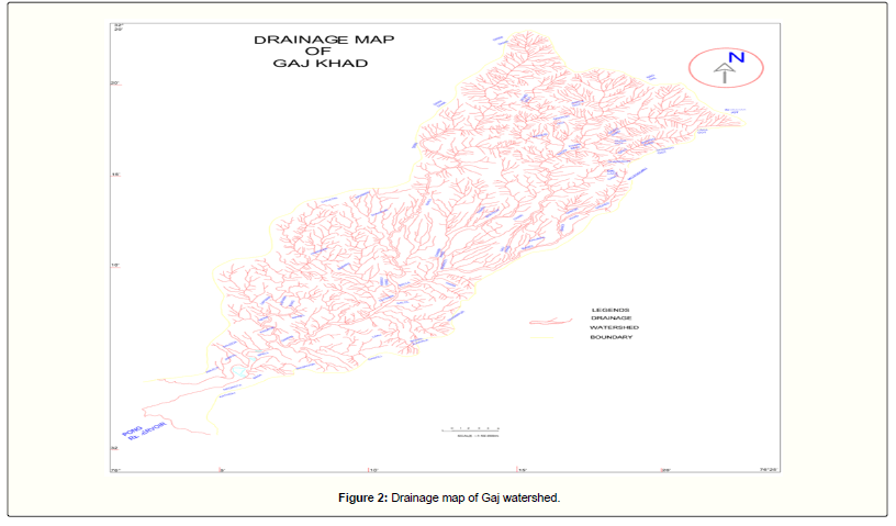
Gaj Watershed is a part of Beas river drainage system of Himachal Pradesh and covers about 503 Km2 area. The study area falls under limits of North latitude 32°0' to 32°25' and East longitude 76°0' to 76°25' (Figure 1). The study area is covered by Survey of India Toposheet no. 52D/3, 52D/4, 52D/7 and 52D/8 under scale 1: 50,000. The study area includes part of Dharamshala, Rait, Shahpur, Ranital, Lanj and Nagrota Surian of Kangra district of Himachal Pradesh. Main tributaries of the watershed are Banoi, Chambi, Khauli and Lapiana (Figure 2).
The watershed area shows a great variation in relief being 418m the lowest and 4600m the highest. Southern end of the watershed shows almost level slope and gentle topography. Small hillocks and dissected hills form a part of Siwalik ranges and slopes also show variations. The north boundary of the watershed area is demarcated by mighty Dhauladhars with highly steeper slopes, cliffs and escarpments. The present study of Gaj watershed is helped by studies of the mentioned authors [1-10].
Research Methodology
Geological setting
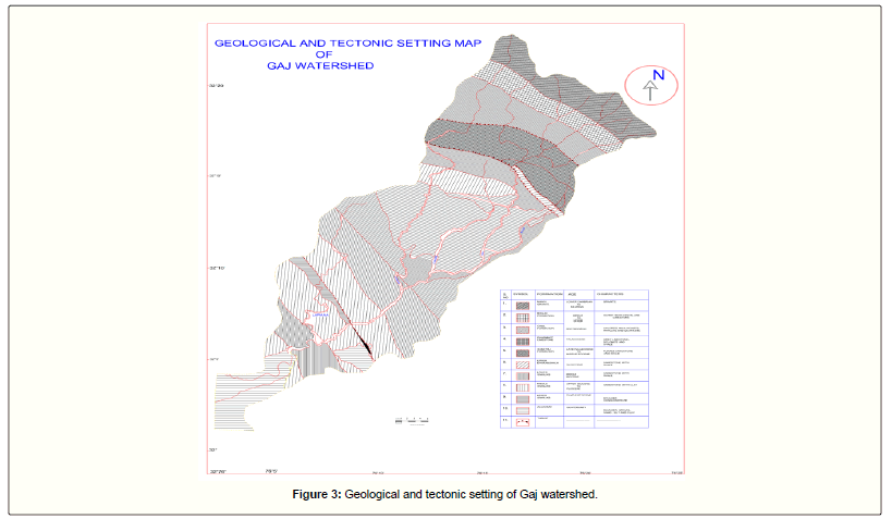
The main group/formations characterizing the watershed area are: Dhauladhar Granite, Chail Formation, Dharamkot Limestone Formation, Subathu Formation, Dharamsala Group and Siwalik Group. The tectonostratigraphic sequence of Gaj watershed is given in Table 1 and Figure 3 [11].
| Group/Formation | Age | Lithology | ||
|---|---|---|---|---|
| Dhauladhar Granite | Precambrian | Granite | ||
| Chail Formation | Precambrian | Gneiss, pyllites, mica schists and schistose quartzite | ||
| Main Central Thrust | ||||
| Dharamkot Limestone Formation | Permian to Triassic | Grey Limestone, Dolomite and purple Shales | ||
| Subathu Formation | Late Paleocene to Middle Eocene | Purple Sandstone and Shale | ||
| Main Boundary Thrust | ||||
| Upper Dharamsala Group | Oligocene | Grey to buff coloured sandstone with red and grey shale | ||
| Drini Thrust | ||||
| Upper Siwaliks | Pli-Pleistocene | Boulder Conglomerate | ||
| Middle Siwalik | Upper Miocene to Pliocene | Sandstone with clay | ||
| Lower Siwalik | Middle Miocene | Sandstone with shale | ||
| Alluvium | Quaternary | Boulder Gravel, Sand silt and clay | ||
Table 1: The tectono-stratigraphic sequence of the area [11].
The Dhauladhar granite formation consists of granites and is best exposed on the trek from Kareri village to Kareri lake and beyond. Dhauladhar Granites are lying tectonically over Chail formation consisting of gneiss, phyllites, mica schists and schistose quartzites. Chail Formation is lying over Dharamkot Limestone formation and it extends from near Kareri in the NW to Khaniyara in the east of Dharmsala. Pande et al. [12] recorded the occurrence of several forms of stromatolites from the grey brecciated dolomitic limestone lying just above the Dharmsala.
Group on the Meleodganj-Galu Devi road. Dharamkot Limestones are resting over Subathu Formation, which is made up of dark grey limestone, purple sandstone and purple red and grey shales. Lahiri [13], named the pre-siwalik mica-devoid, fine to medium grained sandstones and intercalated mudstone sequence as “Dharamsala Beds” [14] divided this group into two parts, i.e., Lower and Upper Dharmsala sub-groups. This group consists of fine to medium grained dirty grey to maroon compact, jointed and non-micaceous sandstones which are interbedded with clay bands of green, maroon and red colour.
Dharamsala formation is lying over Siwalik group, which is overlained by a thrust, named as Drini thrust. Drini thrust is underlain by upper siwalik formation, consisted of conglomerates and a patch of middle siwalik formation (sandstone with clay) is sandwiched inbetween. Base of the watershed area consists of erratic boulders [15] mostly near Amlela, Nagrota Surian and Katholi. Most of the area is covered by fluvioglacial sediments, morainic deposits and alluvium.
Tectonic setting
The watershed area consists of 3 major structural breaks: Main Central Thrust (Chail Thrust), Main Boundary Thrust and Drini Thrust [16].
The Main Boundary Thrust (MBT) regionally separates the Lesser Himalayas from the Sub-Himalayas and shows moderate to steep northerly dips. The Dharamsala and Subathu Formation are exposed between the MBT. Drini Thrust is a secondary fault of MBT which is separating Dharamsala Formation and Upper Siwalik Formation and is best exposed at Drini village. The Main Central Thrust (MCT) is essentially a ductile shear zone that separates the crystalline rocks of the Higher Himalaya from the Lesser Himalaya. Most of the subsequent subduction seems to be occurring along the MCT and MBT [17]. MCT is considered equivalent to Chail Thrust [18].
Landslide activity
Gaj watershed area comes under high annual precipitation. High rates of precipitation when gets mixed with steeper slopes, doubles the risk of slope failures. Larger the precipitation, greater is the infiltration and lesser the soil strength. Along with the precipitation, complex tectonic setting has sculpted the area vulnerable to mass failure. Three major structural breaks namely Chail Thrust, Drini Thrust and Jawalamukhi Thrust have sandwiched most of the study area and tectonic movement along theses fault zones have turned the entire watershed area prone to mass failure, which is frequently experienced in terms of landslips, rock falls and creeps.
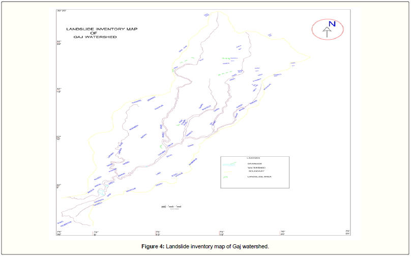
Besides natural risks, the study area is experiencing settlement growth also. Most of the study area falls under moderate to steep slope zone. Hence, growing civilization is capturing these naturally unstable slopes and turning them more unstable. The never-ending demands of civilization have imbalanced the natural drainage and road cuts are drastically exposing the weak zones to failure. Most of the land failures are encountered near road cuts or near settlement areas, depicting the ill effects of human interference to nature (Figure 4).
The major landslide zones studied in the Gaj watershed are as follows:
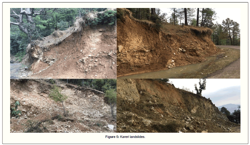
Kareri landslide zone: Kareri village is situated on the upper reaches of the watershed area and falls in the moderate steep slope zone with 30⁰-45⁰ slope ranges. The area is experiencing rapid civilization growth, which is demanding more shelters and roads for communication. Being the hilly area, most of these demands have sculpted the slopes. The area is mostly of Chail Formation and erratic of granites are also encountered.
The main causative factors here are tectonic movements, road cutting and settlement on steeper slopes. Precipitation and seepage are other minor causative factors. Toe cutting due to roads along with poor drainage management of roads have enhanced the failure and if not properly assessed, there are chances for further failures. Retaining walls along the roads are suggested to check the failure due to hydrological factors, such as infiltration and seepage. If needed, a strain gauge can be introduced along with retaining wall. A proper drainage management along the road sides is needed. Trenches made with concrete are suggested to check the toe cutting of slopes during rainy season.
Land failures may be minimized by slope treatment also. Steeper slopes can be graded and turned gentle which may decrease the risk of failure. It is suggested to keep settlement away of these steeper slopes. Keeping in view of the seismic sensitivity of the area, administration is suggested to keep an eye on further settlement and to imply scientific measures for further development (Figure 5).
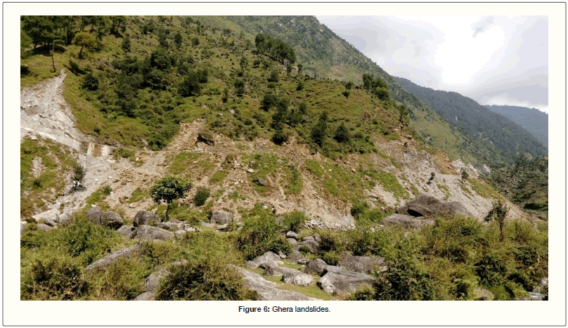
Ghera landslide zone: Ghera village is situated on the western side of Dharamshala Township. A small hydroelectric project is also made on Gaj Khad at Ghera village. The connecting road from Ghera to Kareri is not well metalized and proves useless even after a moderate rainfall (Figure 6).
The entire village is highly sensitive in terms of tectonic activity and displays a beautiful diversity of lithology. Some important lithological formations are encountered here at short intervals of distance. The entire area is sandwiched between Chail Thrust and Main Boundary Thrust. There are great tectonic activities along these structural breaks and are well evident and exposed in the area in the forms of major landslides. Along with this drastic tectonic setting, high precipitation and steeper slopes have turned the area into a major landslide zone, to which under cutting due to stream and toe cutting due to road is also prominent. The slide zone is so great in size that it engulfed a major portion of road and number of trees and vegetation. The rock type is Phyllite and the failure is mainly due to infiltration, toe cutting by road and tectonic activity along Chail Thrust. Poor drainage management along the road sides is also a major causative factor.
Further failure could be assessed by employing retaining walls and proper drainage measures along the road, as hydrologic factors are the main triggering factors.
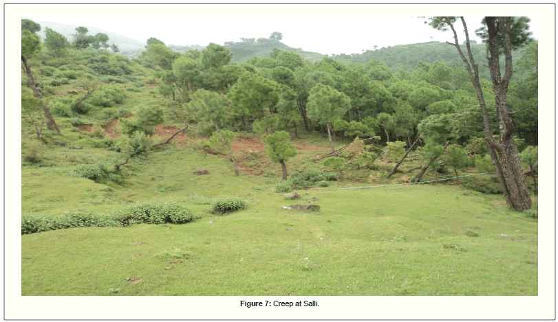
Salli landslide zone: Salli village is situated on the upper reaches of the watershed area in the northwest side. Lithology of the area consists mainly of purple sandstones with clays of Subathu Formation. Area receives moderate to heavy annual rainfall. Village is surrounded by lush green coniferous vegetation. Evidences of slow movements in the form of creeps are encountered in the area. Debris is mainly composed of clay, sandstones and vegetation. Tilting of tree trunks and bended pipes are evidence of slow moving creeps. Infiltration due to frequent precipitation is the main causative facture of this soil failure. If not properly accessed and managed, this movement could turn a big hazard in near future. Slope treatment and plantation can check further movement (Figure 7).
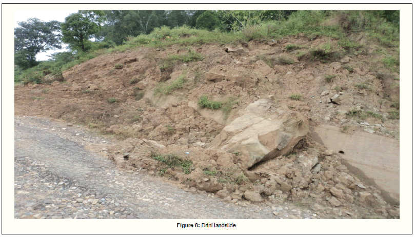
Drini landslide zone: Drini village is situated on a ridge and this ridge is a water divide of Gaj Khad watershed and Dehar Khad watershed. Village is geologically and tectonically very sensitive as a major structural break namely Drini Thrust is there. The thrust has named after the village. A variation of lithology is encountered in the villege. Drini Thrust separates Dharamshala Group from Siwalik Group. Buff colored sandstones of Dharamshala Formation and conglomerates of Upper Siwalik Formation are well exposed in the area, especially in various landslides (Figure 8).
Besides being tectonically sensitive, the village is well populated and various anthropogenic activities adding up to disturbance, in terms of land degradation and erosion. The debris is composed of sandstone and vegetation and the scrap shows that it is a rotational slide. Toe of the slide has damaged some extent of road.
The main causative factor of this slide is movement along the fault zone. Also, poor drainage along road in this tectonically active zone has doubled the risk of land failure. Further movement in the side can risk the road and hence can disturb the communication. To check further disturbance, proper drainage measures are needed and to check further loss of scarp, a retaining wall is proposed.
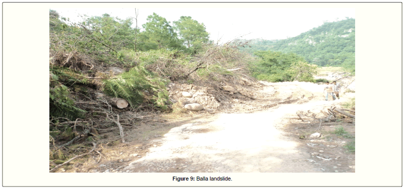
Balla landslide: Balla is a village, near Tatwani hot spring and near the confluence of Gaj Khad and Khauli Khad. The lithology of the area mainly comprises of sandstones and clay of Siwalik Group. The area experience frequent landslides during rainy season. The main causative factors for these frequent landslides are seepage on slopes due to rainfall and road cuttings along slopes. The extent of the slide was so large, that it blocked the road for couple of months. Debris is composed mainly of sandstones of Upper Siwaliks, clay and a huge amount of vegetation. The landslide affected the road as well as affected the vegetation. Entire road was washed away with the debris flow. Slope strength was decreased due to road cutting to which heavy rainfall further decreased the holding strength and resulted in mass failure. Poor drainage along road was also a reason for the land failure (Figure 9).
The road is the main connecting link to Tatwani hot spring, which is quite famous tourist place. The road is frequently damaged during rainy season and gives a huge setback to tourism. To minimize further risk of land slide in this zone, some remedial measures are suggested. The main cause of most of the slides in the region is poor drainage management. Well concreted trenches along the road are needed. To stop further movement of debris along the slope, retaining wall is proposed.
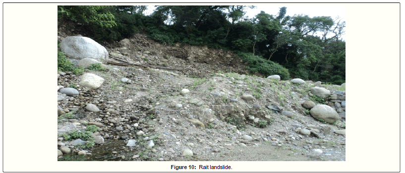
Rait landslide: The displaced debris comprises of huge mass of conglomerate, clay and mud, heaped down on road. Uphill to the slope is highly vegetated and habitated. The slide damaged a portion of road and disturbed the communication. Landslides are frequent in this zone and recently retaining wall was applied to stop the failure, but the wall was also damaged in recent landslide. The main reason for this slide is toe cutting due to road, reducing the slope strength and habitation on upslope. The problem is further aggravated due to heavy rainfall.
Further, widening the road is making slopes steeper and unstable. The slide can remain active for a long time as the crown potion is tilting downwards and the frequent rainfall will further crumple the slope. A strong retaining wall with strain gauge is needed to check the further risk of failure. Proper drainage along road can also help in slope strengthening (Figure 10).
The area experiences heavy annual rainfall and a part of the area receive heavy snowfall. The entire watershed area is highly dissected with stream channels. Percolation due to frequent heavy precipitation and a net of stream channels have turned the watershed area wet and swampy. The overdose of water and seismicity has turned the area vulnerable to erosion and landslides. Frequent tremors and stream channels have eroded a lot of loose sediments and erratic boulders. This erosion has affected the downstream channels and much of the agricultural land. Sheet erosion, side erosion of river banks, creeps, landsides and slumping are encountered frequently in the Gaj Khad watershed area. Higher is the height variation, higher is the erosion intensity.
Due to debris flow and heavy load of eroded sedimentation, the down slope streams are receiving high amount of siltation, which is disturbing agriculture and Hydro-power stations. Besides the seismicity and landslides, human induced activities are also doubling the ill effects in the region. Overburdening population has disturbed the eco-balance in this geologically fragile area. Road cuttings and slope degradation for shelters and agriculture have degraded most of the watershed area. Rapid growing population is demanding habitat, communication and other facilities which are being fulfilled by degrading the neutral and calm mountainous region. Settlement, Road cutting and slope degradation for agriculture have turned the slopes fragile to which deforestation is doubling the risk of sudden slope failures. Many zones are encountered in the study area those are prone to landslides and the main cause for this problem is human only.
Discussion
The present study revealed that most fragile and sensitive zones are near Chail Thrust, Main Boundary Thrust and Jawalamukhi Thrust. These areas should be restricted for further anthropogenic activities such as grazing, agricultural, mining, construction of roads, buildings and dams etc. as these activities are turning the area more vulnerable to hazards. The area should be preserved for growing and developing of thick vegetative cover.
A comprehensive survey of existing infrastructure is needed in the area. The survey should include transport network, means of irrigation, electrification, drinking and agricultural water facilities, education, banking and other services required for a better civilization. A strong prospective development scheme in the region could be thus employed without disturbing the fragile ecology of the area.
The Ghera-Kareri forest road should be well metalized immediately along with suitable drainage measures to prevent it from frequent slope failures which are creating havoc in the area. Retaining walls with strain gauges are needed to provide strength to fragile slopes. So that the economic and ecological development of the area could be restrain.
Conclusion and Recommendations
The fragile and sensitive mountain slopes and other affected sites of the area should be afforested intensively to check further erosion in the area as it costs the resources a lot. The water of the tributaries should be harnessed at the foothill zones for meeting the roaring demands of irrigational and drinking water in the valley. Certain micro hydro power stations should be established in the region. Check dams on some intervals should be constructed to check the debris fall/ erosion. Debris should be filtered to reduce siltation in the downstream regions especially agricultural land and reservoirs. Some NGO’s should come ahead to restore the natural environment of the area.
Acknowledgements
I am extremely grateful to my research guide Dr. Sunil Dhar for his valuable guidance and scholarly inputs. I am obliged to Mr. Dinesh Syal for assisting me in the field. I am deeply indebted to my colleague Mr. Arun Dhawan, whose help, stimulating suggestions and encouragement helped me in all the time of research.
References
- Shukla SD, Verma VK (1974) Geomorpho-statistical investigation in a part of Doon Valley. Garhwal Himalaya. Him Geol 4: 229-239.
- Mithal RS, Prakash B, Bajpai IP (1974) Drainage-basin morphometric study of a part of the Garhwal Himalaya. Him Geol 4: 195-215.
- Lal AK, Pal D (1990) Geomorphic evaluation of morpho-units in the Nayar Basin. Jour Him Geol 1: 225-237.
- Patwary BC, Kumar K (1992) Hydrogeomorphological study of Tawi catchment. NIH Report CS114: 1-51
- Pal D (1998) Quaternary glacial records and neotectonics in the Western Himalaya. Geomorphology and Environment 12: 288-299.
- Shah MP, Pal D (1991) Landform and Neotectonic studies around the Kangra Basin, Himachal Pradesh, using Landsat TM Data. Mountain Resource Management and Remote Sensing 2: 59-71.
- Shah MP, Srivastava RAK (1992) Morphology and facies of the alluvial-fan sedimentation in the Kangra Valley. Sed Geol 76: 23-42.
- Narula PL, Gupta SK, Sharda YP, Singh BK, Joshi KC, et al. (1997) Landslide incidences-A reflection of contemporary crustal adjustment and associated geomorphic anomalies. In: Proc Symp Earth Sciences in Environmental Assessment and Management. Geol Surv Ind Spl Publ 48: 43-49.
- Dhar S, Dhar BL (2002) Geo-environmental impact of slate mining in the Dhauladhar Himalaya. Aspects of Geology and Environment of the Himalaya 4: 329-334.
- Dhar S, Randhawa SS, Sood RK, Kishore N (2006) Lineament control and seismo-tectonic activity of the areas around Dharamshala. Satish Serial Publishing House, Azadpur, New Delhi, India. 2: 73-78.
- Mahajan AK (1991) Seismotectonic activity of the Dharamsala-Palampur area in relation to neotectonics. Thesis in Punjab University, Punjab.
- Pande IC, Dixit PC, Gupta VJ (1971) Stromatolites from the Dharmkot Limestone. Dharmkot. Kangra Dist H P. Journ Ind Geosei Assoc 12: 21-27.
- Raiverman V (1964) Clay sedimentation in the Subathu-Dharmsala Groups of rocks in the foot-hills of NW Himalayas. Bull ONGC 1: 26-86.
- Medicott HB (1864) On the geological structure and relations of the southern portion of the Himalayan ranges between the river Ganges and the Ravee. Mem Geol Surv Ind 3: 1-121.
- Mahadevan TM (1994) Deep continental structure of India: A review. Geol Soc Ind 28: 348.
- Gansser A (1964) Geology of the Himalaya. John Wiley and Sons, NY, USA. p. 289.
- Kumar S, Mahajan AK (2001) Seismotectonics of the Kangra region Northwest Himalaya. Tectonophy 331: 359-371.
Select your language of interest to view the total content in your interested language
Share This Article
Recommended Journals
Open Access Journals
Article Tools
Article Usage
- Total views: 6819
- [From(publication date): 0-2018 - Sep 30, 2025]
- Breakdown by view type
- HTML page views: 5834
- PDF downloads: 985

