Impacts of Climate Change on Rainfall Amount, Onset and Length of Rainy Season over West Africa
Received: 02-Nov-2022 / Editor assigned: 04-Nov-2022 / PreQC No. jescc-22-78233 (PQ) / Reviewed: 18-Nov-2022 / QC No. jescc-22-78233 / Revised: 23-Nov-2022 / Manuscript No. jescc-22-78233 (R) / Accepted Date: 23-Nov-2022 / Published Date: 30-Nov-2022 DOI: 10.4172/2157-7617.1000648
Abstract
Onset, cessation and hence length of rainy season as well as the annual and seasonal amount of rainfall were investigated for a possible climate change impacts in the near future using ensembles of eight regional climate models (RCMs). Comparison of the model ensembles with global precipitation climatology project (GPCP) data shows a good agreement with the observation. Apart from the onset of rainfall and annual amount with error of 51%, 16.5% respectively over Guinea zone, the percentage error for all other parameters were found to be just 10% or less over the zones and in the West African sub-region. Analysis of the present (1997-2007) and its different from the near future (2027-2037) with IPCC scenario A1B shows some reductions (or early) and increment (or delay) in some of these rainfall characteristics. These changes were investigated in each of the three climatic zones and also the entire West Africa. Rainfall amount was found to be reduced to 0.29mm/day (7.9%) over the entire subregion while this reduction is more pronounced in the Sahel (with 0.37mm/day) than the other two zones. Throughout the three zones and of course the entire West African sub-region, there is general delay of onset, early cessation and therefore shorter length of rainy season. Over Guinea, length of rainy season was reduced by 27 days while it was 14 and 13 days respectively over Savana and Sahel, the mean over West Africa is 18 days. This threatens the agricultural practices and therefore calls for a way of getting plant species that mature and germinate early enough so at to mitigate the impacts of shorter length of rainy season in the near future over West Africa. Though, there seems to be a relief in the rainfall amount from June to September over Guinea as there is an increase of 1.63mm/day (25%), but this poses some threats in terms of damages and destruction to lives and properties that may be associated with frequent occurrences of floods and probably squall lines. Savana has little reduction of 0.3mm/day while the reduction is a bit high over Sahel with 1.0mm/ day, this threatens agricultural practices and water resources management over these zones as the rainfall amount over them presently is not substantial enough for a sustainable agricultural practice.
Keywords: Rainfall characteristics; West Africa; Climate change; Mitigation; Model ensembles
Introduction
The impact of global warming is not limited to global and regional changes in temperature alone. It also has significant impact on regional rainfall patterns, which may not only alter rainfall amount, but the length of growing season as well as its distribution over the region. There would be a lot of economic, social and scientific benefits if the impacts of climate change on rainfall properties can be investigated over the West African sub-region in which majority of the inhabitants practice rain fed agriculture due to the developing nature of the constituent countries. Global climate models (GCMs) are useful tools in studying possible future trends in climate of the world through the development of some climate change scenarios. These are some specific assumptions for the evolution of greenhouse gases as presented by the Intergovernmental Panel on Climate Change (IPCC, 2007). GCMs, when simulate with these scenarios are capable of providing general information for most climate variables.
A lot of research work has proposed that increase of atmospheric greenhouse gas concentrations could result into increase in air temperature and frequency of heavy precipitation in many regions of the world [1-2]. Unfortunately, due to the limitation of computing power and better representation of local or regional climates, they are generally unable to represent surface homogeneities on scales less than about 100 km. This scale is considerably coarser than typical scale of the impacts [3]. However, global climate change has an influence and feedback effects on these local and regional scales. It is noteworthy that the scales of systems that control and dominate the weather and climate of West Africa are typical of mesoscale systems which are responsible for over 70% of West African annual rainfall [4].
Results from GCMs are therefore unsuitable as direct inputs to climate change impact studies and may be considered with some reservations because of the sub continental pattern and magnitude of the change as well as the coarse grid spacing earlier mentioned which poses limitations to the explicit simulation of local and mesoscale processes which are rainfall-producing mechanisms, good representation of topography, land cover and land-sea distribution. Regional climate models (RCMs) are promising tools for improved information on regional climate change and its impacts. This has been better achieved by using nested RCMs [5], statistical downscaling and recently dynamical downscaling [6]. This work will focus on dynamical down scaling a common GCM using eight RCMs.
Climate has a strong impacts and influence on agriculture, the most weather-dependent of all human activities, with severity of impacts varying from one location to another [6]. These impacts are very strong in the developing countries around the tropics because of the exposure to high variability in monsoon system over West Africa and Indian [7], and where poverty increases the risk and impacts of natural disasters UNDP (2004). This is particularly the case over West African where a rained agricultural practice is the major source of food and income and also mechanisms to control such impacts are unavailable. This study therefore aims to investigate the impacts of climate change in the very future on rainfall amount (annually and seasonally), onset, cessation and length of rainy season. Next section gives a description of observation and experiment that produced the RCMs, while section three presents the results of model validation with observation and then compares the present with near future simulation. Section four gives the conclusion and recommendation.
Data and Methods
Description of regional climate models and the observational data used
Ensembles data of eight regional climate models were used for the study. These models were part of the RCMs used for the research theme 3 (RT3) of the ENSEMBLES project. It is being coordinated by the Hadley Centre at the Met Office in the UK. It directly addresses the key objective of the United Nations Framework Convention on Climate Change (UNFCCC) including the Kyoto Protocol and the Intergovernmental Panel on Climate Change (IPCC). Detail of the project is available at http://ensembles-eu.metoffice.com/docs/Ensembles_final_report_ Nov09.pdf. The research theme 3 which is “Formulation of very-highresolution of Regional climate model ensembles for Europe” included a study of West African climate [8] leading to a close collaboration with the African Monsoon Multidisciplinary Analysis (AMMA) project. On one hand, regional climate modeling provided input to the process and impact studies by AMMA and on the other hand, AMMA made available the observational data for RCM observation.
The RCMs have some similarities and these are; they have the same resolution of 0.44o latitude by 0.44o longitude (50km X 50km); ERAInterim reanalysis is used as the initial and boundary values for the present climate simulations; they all cover major part of Africa; and are mostly from 1989-2007. List of the models and their respective developers (institutes) are given in Table 1. The driving GCM indicated in this table is the general (global) circulation model that was used for the future climate simulation given the scenario A1B of the IPCC. The present simulations for most of the RCMs are from 1989-2007 and future simulation is from 2010-2050 for the project. But for the present study, daily rainfall data of the global precipitation climatology project (GPCP) were used to validate the present simulations of RCMs. Because GPCP data started in 1996, validations of the ensembles with GPCP were performed from 1997 to 2007 thus having eleven years as validation period. GPCP hereinafter referred to as observation data has the same resolution of 50km by 50km with the ensembles and therefore gives room for easy comparison. Percentage error is computed as follows

Method of Analysis
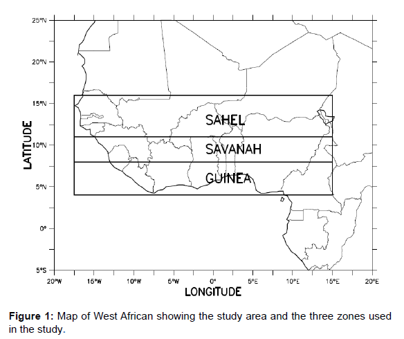
Several definitions of onset of rainfall exist in literature, but the definition of Omotosho et al., [9-12] which is in use at African Centre for Meteorological Application for Development (ACMAD) and Nigerian Meteorological Agency (NIMET) is employed because of its general acceptability and its direct application for agrometeorological purposes. Onset, cessation and hence length of rainy season over the eleven years of validation period (1997-2007) were evaluated from the models as well as the observation. This period is also referred to as the present ensembles. Annual amount of rainfall, rainfall amount from June to September (JJAS) and seasonal rainfall amount which is rainfall between onset and cessation were also evaluated. Figure 1 shows the study area over the West African sub-region with three major climatic zones in which emphasis of the research is majorly placed upon. It should be noted that the region of interest in this study compares to the data range listed in table 1 is small and far away from the boundary value problems and effects that may arise from the simulations. Present ensembles of the eight models were first compared with the observation in order to investigate the agreement between the ensembles and observation over the region of interest. Later, the future simulation of another eleven years 2027-2037 were then compared with the present ensembles over the entire West Africa and also over each zone so as to investigate the impact of climate change on these rainfall characteristics.
S/No |
Institute | Model | Acronym | Latitude Range | Longitude Range | Driving GCM |
|---|---|---|---|---|---|---|
| 1 | DMI | HIRHAM | DMI-HIRHAM | 19.80S -34.76N | 35.64W-34.76E | ECHAM5-r3 |
| 2 | GKSS | CLM | GKSS-CLM | 19.80S -35.20N | 35.20W-31.24E | ECHAM5 |
| 3 | HC | HadRM3P | METO-HC_HadRM | 19.80S -35.20N | 35.20W-31.24E | HadRM3P |
| 4 | ICTP | RegCM | ICTP-REGCM3 | 38.53S -38.88N | 37.91W-62.36E | ECHAM5-r3 |
| 5 | KNMI | RACMO | KNMI-RACMO2 | 25.00S -40.00N | 35.20W-31.24E | ECHAM5-r3 |
| 6 | METNO | HIRHAM | METNOHIRHAM | 25.00S -40.00N | 35.20W-31.24E | HadCM3Q0 |
| 7 | MPI | REMO | MPI-M-REMO | 25.00S -40.00N | 35.20W-31.24E | ECHAM5-r3 |
| 8 | SMHI | RCA | SMHIRCA | 25.00S -40.00N | 35.20W-31.24E | HadCM3Q0 |
Table 1: Description of the Regional Climate Models used for the study.
Results and Discussion
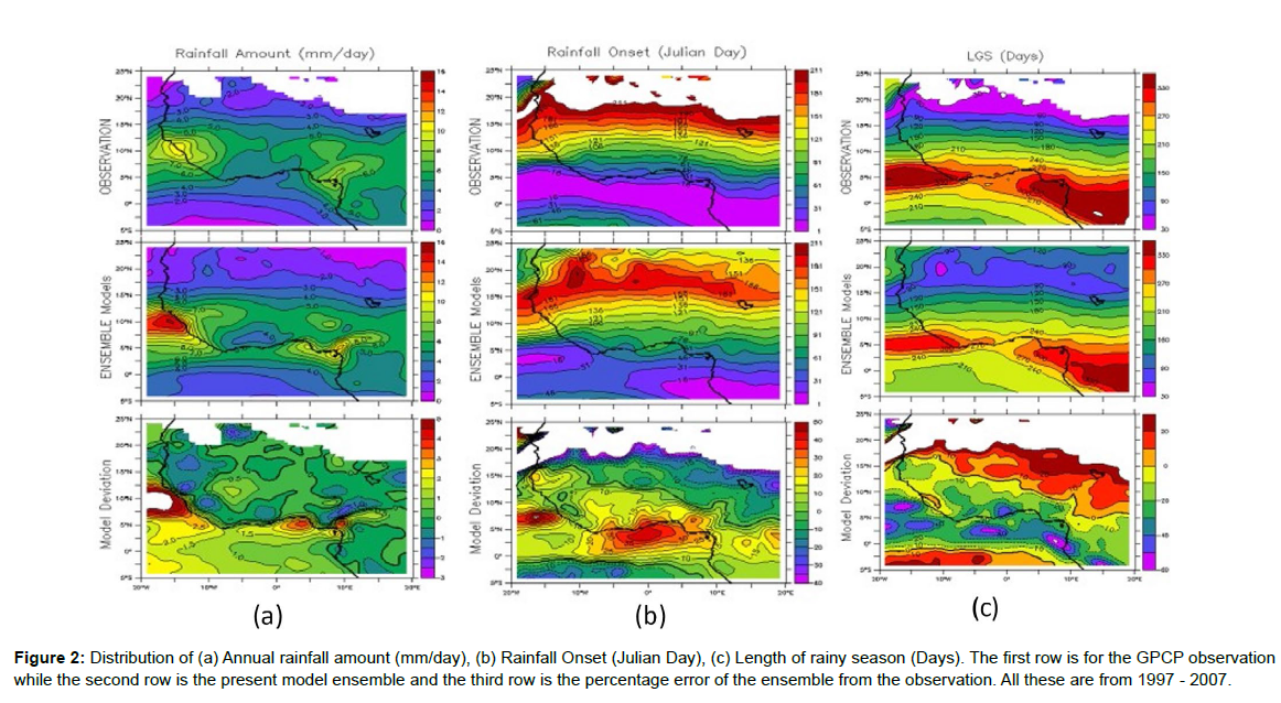
Figure 2 shows the spatial distributions of (a) annual rainfall amount (mm/day) drawn at interval of 1.0mm/day; (b) onset of rainfall (Julian day) at interval of 30 days; and (c) length of rainy season (days), also at interval of 30 days. The first column is for observation while the second column is the present ensembles and third column is the percentage error between the model ensembles and observation, with contours drawn at interval of 20%. Comparing the first and second column for these three rainfall features, it is obvious that the patterns in the observation were well captured by the model ensembles. For rainfall amount, the range of values between latitude 15oN and around 2.5oN are virtually the same but with an overestimation along the coast of Sierra Leone and over Nigeria which coincides with the leeward side of the Cameroonian mountain. This is in agreement with the results of ensemble by [10]. The error analysis of the rainfall amount shows that apart from the ocean and coastline that were overestimated by close to 40%, all other areas up to around 15oN are within ±20% and this is considered to be a very good estimate.
Figure 2: Distribution of (a) Annual rainfall amount (mm/day), (b) Rainfall Onset (Julian Day), (c) Length of rainy season (Days). The first row is for the GPCP observation while the second row is the present model ensemble and the third row is the percentage error of the ensemble from the observation. All these are from 1997 - 2007.
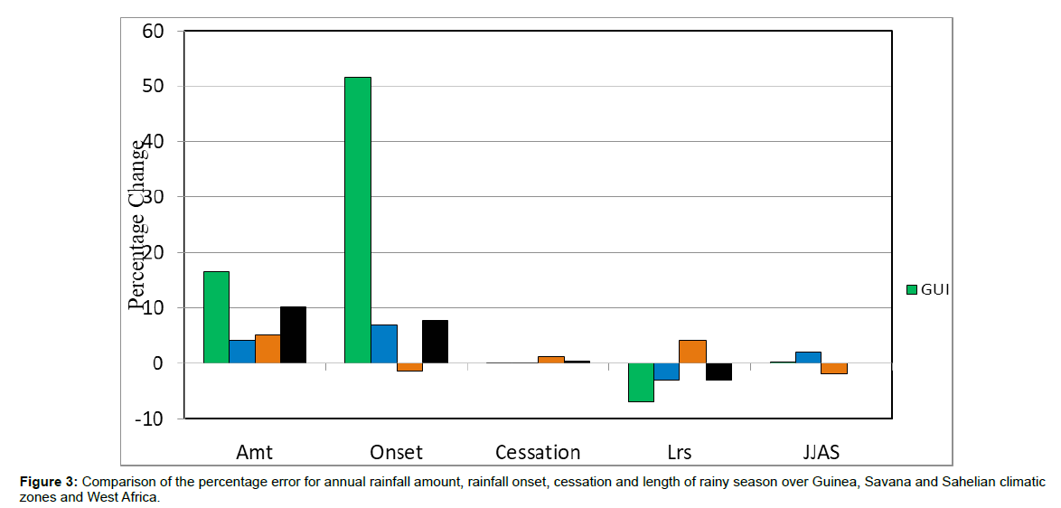
For the other two properties, the patterns are also similar and even more precise, other than the ensembles gave late onset dates over the Guinea area. This is better observed in Figure 3 as it compares the errors between the ensembles and observation for the three climatic zones and the mean of the entire West Africa. It was glaring that length of rainy season was well captured with percentage error of -10% in all the three zones and their mean denotes as W/A which is the average of the three zones and also referred to as West African average. The amount was equally well estimated by the present ensembles in Sahel and Savana zones with less than 10% (0.1mm/day) but 17% (0.76mm/ day) over Guinea, this is due to the two areas over the ocean where the present ensembles overestimated that were just mentioned but the average of the three zones still gives a very reasonable and encouraging results. The Onset was perfectly captured over Sahel and Savana but was very delayed by 51% (21 days) over Guinea. It should be noted that if the Ocean areas were blanked out, a good result was also simulated over Guinea. The average over the entire sub-region is less than 7.8% (8 days) and was taken to be reasonably good. The ensembles were believed to replicate the West African features very well and can therefore be used for climate change studies.
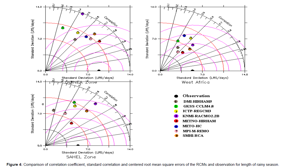
To further evaluate the performances of these eight models, Figure 4 presents the comparison of the eight models and observation using their correlation coefficients, standard deviation and centered root mean square errors for length of rainy season. This was done for other properties considered but not displays due to have similar results. This shows that some of these models actually have good statistical values when compared to observation. The correlation coefficients are from moderate to high, with small standard deviations and root mean square errors. The best four selected were used for the possible climate change impacts on these properties over the zones and West Africa.
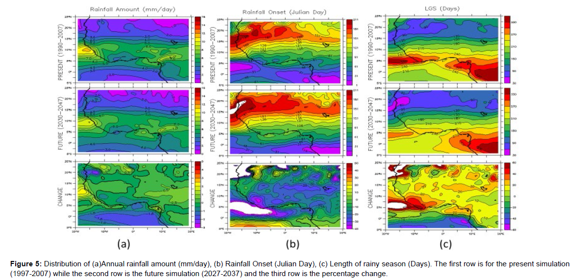
Figure 5 is similar to Figure 2 other than it displays the present ensembles otherwise referred to as present in the first column, while future ensembles otherwise referred to as future is in the second column and the percentage change otherwise referred to as change is in the third column. It shows that rainfall amount will decrease to about 20% in the area between 12.5oN to about 16oN with much more rainfall over the ocean. Generally, the increase in rainfall amount over West Africa is between -20% in the northern part to about 20% in the southern part of West Africa. There are no pronounced changes in the onset which means that the percentage change is within ±20 over the West Africa, but there is early onset over the coast of West Africa and that of Dakar in Senegal. Length of rainy season was shortened along the coast of West Africa from 270 days to about 240 days. The general change over the entire West Africa is within ±20% from the present values.
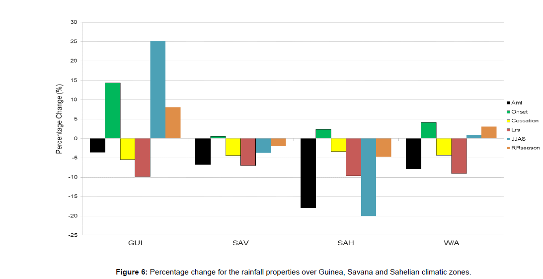
Comprehensive percentage change of five rainfall characteristics over each climatic zone and entire West Africa is given in Figure 6. These are rainfall amount, onset and cessation of rainfall, length of rainy season, June to September (otherwise JJAS) and seasonal rainfall amount. Seasonal rainfall amount is the total amount of rainfall that falls within the length of rainy season. It is clear here that there is a general decrease of rainfall amount over the entire sub-region of West Africa. It is more pronounced in Sahel more than other zones with about 18.3% (0.27mm/day) reduction. The reduction over Savana and Guinea are respectively 6.7 and 3.6 % (0.19 and 0.37 mm/day), thus given an average of 8% (0.29mm/day) reduction over the entire West Africa. Onset of rainy season is delayed in the entire sub-region with Guinea having the highest delay of about 14.3% (9 days) while Sahel has a delay of about 2.3% (4 days). There is virtually no change (a change of 0.6%) over the Savana zone. This therefore gives an average of 4% (5 days) of delayed onset over the West Africa. This will have a significant effect on agricultural practices in West Africa, most especially over the Guinea zone as regards effective planning of farmland because farmers will have to wait several days after the usual climatological onset of rainfall.
There is a general early cessation of rainfall over the three zones and thus, the entire sub-region. The change is least over Sahel with 3.4% (10 days) earlier and 5.4% (18 days) earlier over Guinea. That of Savana is 4.4% (14 days) earlier and the regional average is 4.5% (14 days). The combined effects of the delayed onset and early cessation are observed in the drastic reduction in the length of rainy season as seen from the Figure 6. The percentage reduction over Guinea and Sahel 9.9 and 9.7 respectively (27 and 13 days) while it is a bit lower over the Savana which is 7% (14 days) and an average of 9% (18 days) over the entire sub region. The general reduction in the length of rainy season will have a lot consequence on human lives, animals and plants. The comfortable wet season over the sub-region will be reduced in the near future, length of growing season will therefore be affected, a lot of perennial crops will be adversely affected. In order to mitigate the impacts of shorter length of rainy season, crop species that mature and germinate earlier should be researched into in order to mitigate the impacts of this reduced length of rainy season may have on socioeconomy of West Africa.
The rainfall amount for June, July August and September (JJAS) and the seasonal rainfall show another pronounced change over the Sahel and Guinea. There is an increase of 25.12% (1.63 mm/day) over Guinea while Sahel has a decrease of 20% (1 mm/day), that of the Savana is not much, just 4% (0.3 mm/day) reduction. The astronomical increase over Guinea might be blessing to an extent for farmers but it makes the area prone to frequent (and most likely increase the number of) occurrence of flash floods and squall lines which also destroys properties, washes away nutrient-rich topsoil and wastes lives. Even heavy rainfall within a short period of time may cause water-logging and in most cases not suitable for proper germination of some crops that require little amount of rainfall. Each crop has its own weekly crop-water requirements; an amount which when exceeds may have adverse effects on the growth and germination of seedlings and the eventual harvest. Disaster managers and policy makers concerning flood occurrence and the destruction of properties as a result of the gust associated with squall line occurrence should be aware of the likely imminent danger ahead.
Conclusion and Recommendations
It was generally observed that the amount of rainfall over the entire West Africa will be reduced by 7.9% with Sahel being mostly affected with 18% reduction. This reduction in annual rainfall amount is also reflected in the June to September rainfall amount as well as seasonal rainfall most especially over Sahel with 20% and 5% respectively. The respective reductions over Savana are 3.6% and 2% which are not too significant. The Guinea zone instead experiences increase of 25% and 8% for JJAS and seasonal rainfall amount respectively. This suggests a problem of flooding over this zone as more rainfall will be received within this short period. It should also be noted that thunderstorms and squall line that are responsible for more than 70% of the rainfall over the zone are always associated with destruction of properties because of the accompanied gust. So, proper mitigation measures such as well constructed drainages and trees and other wind breaker strategies should be put in place in order to alleviate the imminent effects.
It was also observed that rainfall onset was delayed while cessation was earlier than present in all the three zones and hence over the entire West Africa, thereby shortening the length of rainy season. Onset was delayed by 14.3% over Guinea but was low over other zones and in the entire sub-region (values less than 5%), while cessation was around 5% in all zones and the region. This therefore produces a shorter length of rainy season of with10% over Guinea, Sahel and the entire region but a bit lower (7%) over Savana. This shortening in length of rainy season tends to negatively affect the agricultural production of the subregion. Plant species that mature and germinate earlier might be a good way of mitigating the effects of this climate change over a developing subregion of West Africa.
Acknowledgement
This first author is grateful to the Education Tax Fund (E.T.F) which was used to fund the trip to South Africa where the research was conducted and to the anonymous reviewers who contributed immensely to the quality of the paper The effort of European Union for their sponsorship of ENSEMBLE and COORDEX data is greatly acknowledged.
References
- Achugbu IC, Anugwo SC (2016) Drought Trend analysis in Kano using standardized precipitation index. Fuoye J Pure Appl Sci 1(1):105-110.
- Adefolalu SO (1986) Further aspects of Sahelian drought as evident from rainfall Regime of Nigeria. Arch Met Geoph Biolcl Ser B 36:227-295.
- Aper JA (2006) Stream Discharge Characteristics in the Lower Benue Drainage Basin. Ph.D. Thesis Submitted to the School Of Graduate Studies. University of Nigeria Nsukka.
- Bhavnani R, Vordzorgbe S, Owor M (2008) Report on the Status of Disaster Risk Reduction in the Sub-Saharan Africa Region. Commission of the African Union.
- Binboll NL, Edicha JA (2012) Drought risk assessment in Yola, Adamawa State Nigeria. KAJONAS 2(1): 2004-2011.
- Duan JG, Nanda SK (2006) Two-dimensional depth-averaged model simulation of suspended sediment concentration distribution in a groyne field. J Hydrol 327(4):426-437.
- Farauta BK, Egbule CL, Idrisa YL (2011) Climate change and Adaptation Measures in Northern Nigeria: Empirical Situation and Policy Implications. ATPS.
- Fabeku BB, Okogbue EC (2014) Trends in Vegetation Response to Drought in Sudano- Sahelian Part of Northern Nigeria. J Atmos Sci (4):569-588.
- Gautam M (2006) Managing Drought in Sub-Saharan Africa; Policy Perspectives. Ag Econ Sear 9:1-18.
- Halimatou TA, Kalifa T, Baffour N (2016) Farmer’s perception on Climate variability in Cinzana, Mali. J Agric Res 4(3):13-36.
- Koudahe K, Kayode AJ, Samson AO (2017) Trend analysis of Standardized Precipitation Index in the context of Climate Change in Southern Togo. Clim Atmos Sci 7:401-423.
- Mavromatis T, Stathis D (2011) Response of the Water Balance in Greece to Temperature and Precipitation Trends. Theor Appl Climatol 104:13-24.
Indexed at, Google Scholar, Crossref
Indexed at, Google Scholar, Crossref
Indexed at, Google Scholar, Crossref
Indexed at, Google Scholar, Crossref
Indexed at, Google Scholar, Crossref
Indexed at, Google Scholar, Crossref
Indexed at, Google Scholar, Crossref
Citation: ADEFISAN EA (2022) Impacts of Climate Change on Rainfall Amount, Onset and Length of Rainy Season over West Africa. J Earth Sci Clim Change, 13: 648. DOI: 10.4172/2157-7617.1000648
Copyright: © 2022 ADEFISAN EA. This is an open-access article distributed under the terms of the Creative Commons Attribution License, which permits unrestricted use, distribution, and reproduction in any medium, provided the original author and source are credited.
Share This Article
Recommended Journals
Open Access Journals
Article Tools
Article Usage
- Total views: 1512
- [From(publication date): 0-2022 - Mar 13, 2025]
- Breakdown by view type
- HTML page views: 1256
- PDF downloads: 256

