Geographic Information Systems and Multi Criteria Decision Analysis Based Habitat Suitability Analysis for Ethiopian Wolf (Canis simensis) Species at Bale Mountains National Park, Ethiopia
Received: 27-Jan-2022 / Manuscript No. JEE-22-47412 / Editor assigned: 31-Jan-2022 / PreQC No. JEE-22-47412 (PQ) / Reviewed: 15-Feb-2022 / QC No. JEE-22-47412 / Revised: 18-Feb-2022 / Manuscript No. JEE-22-47412 (R) / Published Date: 25-Feb-2022 DOI: 10.4172/2157-7625.1000317
Abstract
Wildlife management is a crucial issue to maintain sustainability of an ecosystem whereas habitat suitability analysis is very important for better conservation and management of endangered species like Ethiopian wolves. So that, the effort of this study was to analyze habitat suitability for Ethiopian wolf (Canis simensis) species through employing Geographic Information Systems and Multi Criteria Decision Analysis at Bale Mountains National Park, Ethiopia. The study employed nine datasets include: land use/land cover, soil, elevation, slope, temperature, rainfall, settlements, roads and rivers. In this study, Analytic Hierarchy Process (AHP) and weight overlay analysis methods were applied using IDRISI 17 and ArcGIS 10.5 software. Each datasets was integrated using Geographic Information Systems and Analytic Hierarchy process to rate the individual classes of each factor and weight the influence of one factor against to the other, to determine the weighted contribution of importance to the habitat suitability. As result the consistency ratio was 0.05% and found with acceptable limits. Then, the weighted overlay tool was applied to calculate the final habitat suitability map of Ethiopian wolf species based on the influence value. The result indicates, from the total of the study area 65.7% was suitable and 34.3% was not suitable for Ethiopian wolf’s habitat. Therefore, according to the results of the finding more areas of Bale Mountains National Park are suitable for Ethiopian wolf species based on the factors employed in the study. So that, this indicates the area is important for conservation from habitat loss and fragmentation.
Keywords
Analytic hierarchy process; Bale mountains national Park; Ethiopian wolf; Geographic information systems; Habitat; Multi criteria decision analysis
Introduction
Wildlife management is an issue of global importance where its habitat suitability mapping is an essential for the better management and conservation. It is not only preservation of wildlife species, but it also involves management of a complete ecosystem. Moreover, it attempts to balance the needs of wildlife with the needs of people using the best available science. Wildlife management includes game keeping, wildlife conservation and pest control [1].
Habitat loss, fragmentation and degradation pose direct threats to wildlife species worldwide that driven by human population growth, unsustainable consumption of natural resources and policies that do not fully value biodiversity. Habitat destruction is widely accepted as the leading cause of wildlife extinction rates in recent decades. Furthermore, fragmentation and habitat loss, due to anthropogenic pressures is one of the major challenges to conservation and is considered a major threat to the viability and status of populations, species, and ecosystems around the world.
Habitat destruction and fragmentation are the most critical threats to biodiversity and ecosystem throughout the world. It affects the survival of wildlife populations through reducing the amount of available habitats, reducing habitat quality, and creating edge effects. Habitat loss has pervasive and disruptive impacts on the biodiversity and its magnitude of the ecological impacts can be exacerbated by habitat fragmentation.
In Ethiopia, The expansion of agricultural practices, settlement in and around the Sanctuary, increasing pressure from human and livestock population are major threats to several protected areas. Additionally, Lack of proper management is problems that are threatening the quality and quantity of wild biodiversity in Ethiopia [2].
In Bale Mountains National Park, habitat loss and fragmentation is rapid and poses a severe threat to survival of most of wildlife species. It has been under increasing pressure from rapidly growing human population; agricultural land expansion (ETFF, 2007) and the increment of livestock number. Encroachment from the surrounding communities is currently among the major problems of the park is facing. Consequently, it becomes one of the highly endangered parks of the country.
Ethiopian wolf (Canis simensis) is endemic to the highlands of Ethiopia and they are Africa’s rarest and most endangered canid. The Bale Mountains contain the largest number of individuals, with approximately half of the estimated population size. According to Marino and Sillero-Zubiri (2013) Ethiopian wolves were classified as Endangered in 2004 under the IUCN Red List, as the population is affected by habitat fragmentation combined with a continuing decline in numbers of mature individuals [3].
In the Bale Mountains National Park, wolves live in close contact with people. While this coexistence is usually encouraged, it places the wolves at great risk of canid-related diseases like canine distemper and rabies, habitat loss and fragmentation, and hybridization with domestic dogs. A Continuous loss of habitat due to high-altitude subsistence agriculture expansion represents the major threat for wolf species.
Therefore, Geographic Information Systems is an excellent tool for identifying areas of conservation significance and assessing the habitat potential sites.
It enables wildlife distributions, movements and habitat use patterns and processes to be mapped and analyzed, which can provide valuable information for the development of management strategie. The use of Geographic Information Systems for mapping, monitoring, analyzing and modeling habitats of wildlife populations has become increasingly widespread [4].
Therefore, this study was aimed at utilizing the Geographic Information Systems and Multicriteria Decision Analysis methods for analyzing the suitable habitat sites for Ethiopian wolf (Canis simensis) species in Bale Mountains National Park.
Materials and Methods
Data types
The data were used for the habitat suitability analysis includes satellite imagery of Landsat 8, climatic data (temperature and rainfall), Shuttle Radar Topography Mission (SRTM) with 20 m resolution (elevation and slope), soil data of FAO classification, toposheets (rivers and roads) and settlements [5].
Sampling stations
For data preparation, organization, data analysis and output generation, hardwares and software were used. The hardwares include Personal Computer, Printer, GPS receiver and digital camera was used. Softwares used for data processing and preparation, data analysis, editing and output generation include ArcGIS 10.5, Microsoft office, ERDAS IMAGINE 2015 and IDRISI 17.
GIS database design
A file Geodatabase was created using the ArcCatalog 10.5 and the feature dataset was projected using of the Universal Transverse Mercator (UTM) projection system Zone 37 N and datum of Adindan to ensure consistency between datasets [6].
Methods of data analysis and processing
To analyze the habitat suitability of Ethiopian wolf in Bale Mountains National Park, Literature Review and Expert Opinion Habitat Suitability Model were applied. As a result, beside the discussion with Ethiopian Wolf Conservation Programme and Bale Mountains National Park members, published and unpublished materials were reviewed. Additionally, field investigation was done to identify the present situation wolf at Bale Mountains National Park. Generally, in the process of habitat suitability analysis for Ethiopian wolf nine factors including land use/land cover, elevation, slope, temperature, road, river, rainfall, settlement and soil were used [7].
The study was employ land use/land cover interpretation and classification of the study area as one factor. As a result, landsat8 image of resolution 30 m with path and row of 167/055/056 and 168/055 of year 2017 were used by downloading from United States Geological Survey websites. Then image geometric correction and stacking layer of each band has been conducted subsequently by using of ERDAS IMAGINE 2015 software. Following of that, mosaicking of three scenes were made in order to clip the images of the study area. Supervised classification was performed to classify the land use/ land cover of the Bale Mountains National Park. After that Accuracy assessment of the classified image was done by field observation and data collected using of hand held GPS apparatus from sample areas to match the classified image with ground features [8]. Finally, the classified land use land cover image crosschecked by overlaying with Google Earth Image using ERDAS IMAGINE 2015 software.
The other was analyzing of the Temperature and Rainfall data. The Temperature and Rainfall data were collected from National Meteorological Agency (NMA) stations around study area. Ten years (2006-2016) temperature and rainfall data from eight stations were used. The stations were Dodola, Agerfa, Sinana, Robe, Dinsho, Adaba, Dellomena and Goba. The temperature data was analyzed based on mean monthly temperature that has been calculated from the mean monthly maximum and mean monthly minimum temperature of each station. For the rainfall, the analysis was done based on average annual rainfall that has been computed from monthly rainfall data. Then interpolation applied to the surface of the study area using kriging tool.
Road and river were digitized from the toposheets collected from Ethiopian Mapping Agency and settlement data gathered from Frankfurt Zoological Society Bale Mountains National Park offices in shapefile format and using of ArcGIS 10.5 software proximity computation performed and analyzed.
The Elevation and Slope of the study area were generated from Shuttle Radar Topography Mission (SRTM) 20 meter resolution that was downloaded from the United States Geological Survey websites and analyzed using ArcGIS 10.5 software. In this research, Soil data of FAO classification was used. The data Analysis was done by using the major soil types found in the study area [9].
After each variable were converted from vector to raster (rasterization process) continuing through performing of their analysis, reclassification was performed on the basis of attribute value that has specified through ArcGIS software.
Analytic hierarchy process weights
Pairwise comparison method in the context of Analytic Hierarchy process was used for evaluation of the factors. Each assigned weights for the factors were based on a multi-criterion evaluation Analytical Hierarchy Process. The Analytic Hierarchy process uses a nine-point measurement scale i.e. 1-Equal importance, 3-Moderate importance, 5-Strong importance, 7-Very strong importance, 9-Extreme importance. The other values of 2,4,6, and 8 constitute intermediate values between two adjacent values [10].
Weighted Linear Combination
The Weighted Overlay tool applies one of the most used approaches for overlay analysis to solve multicriteria problems such as suitability models. Each of the factors in the weighted overlay analysis may not be equal in importance.
Weighted overlay analysis computed using their Influence value assigned to each factors based on their significance in deciding of habitat suitability for Ethiopian wolf [11].
Results
All factors used in the study were geo-referenced, loaded in to the Geodatabase, converted in to raster format, and reclassified according to their suitability classes in the ArcGIS environment. After the reclassification process, the suitability classes were identified for each factor.
The factor maps were reclassified based on FAO (1985) land suitability classification standard. Its Suitability Classes are highly suitable, moderately suitable, marginally suitable, currently not suitable and permanently not suitable [12].
In this regard, highly suitable, moderately suitable and Marginally Suitable are areas which in general called habitat suitable range for Ethiopian Wolf species.
Whereas currently not suitable and permanently not suitable are areas that not suitable for Ethiopian Wolf species.
Land use Land Cover
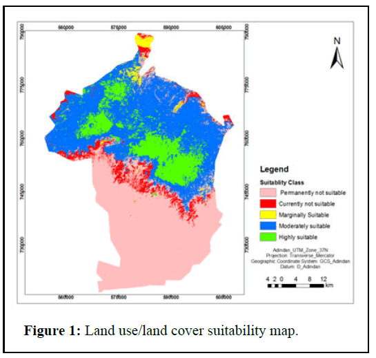
Land use land cover of the study area was one of the criteria used to select habitat sites for Ethiopian wolves. Wolves utilize all Afroalpine habitats, but prefer open areas with short herbaceous and grassland communities where rodents are most abundant.
Prime habitats in the Bale Mountains are characterized by short herbs, grasses and low vegetation cover. Other good habitats include tussock grasslands, high-altitude scrubs dominated by Helichrysumspp and short grasslands.
Afroalpine meadows and Ericaceous moorlands with open moorlands having patches of herbs and grasses are relatively good habitat for them (Figure 1) [13].
Elevation
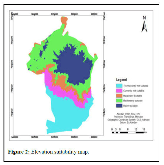
Suitable habitats of Ethiopian wolf are extending from above tree line at about 3,200 m up to 4,500 m above sea level, with some wolves present in montane grasslands at 3,000 m above sea level. The highest Ethiopian wolf population densities are found in short Afroalpine herbaceous communities, lower densities are found in Helichrysum dwarf-scrub and in ericaceous heathlands and barren peaks. Wolves are also present at low density in montane grasslands at lower altitudes. According to the information gathered from Ethiopian wolf conservation program experts, 10 years ago Ethiopian wolf was confined in the gaysay grasslands of the park but presently wolf species are living above the elevation of 3600 m above sea level (Figure 2) [14].
Slope
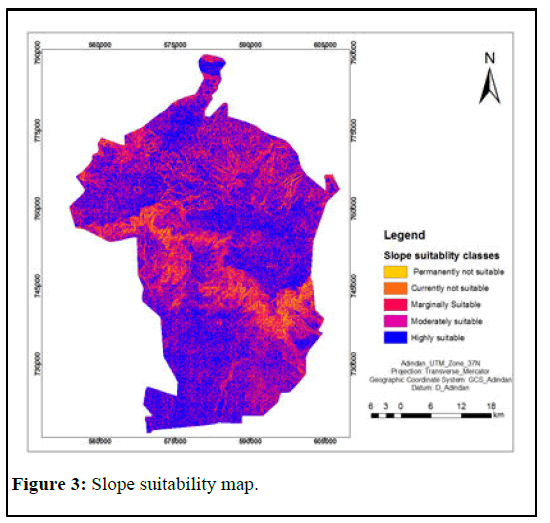
According Marino and Sillero-Zubiri (2013) the suitable habitat for Ethiopian wolves on the slope point of view is along flat or gently sloping areas. So that wolves prefer gentle slope rather than steep slope on the slope gradient perspective. As a result, Slope has been identified as an important factor for wolves especially greater during hunting of small mammals. Gentler slopes are more preferable and energy saver during hunting rather than the steepest slope (Figure 3).
Soil
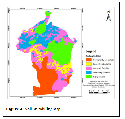
Soil map of the study area was one of the criteria used to select suitable habitat sites for Ethiopian wolf at Bale Mountains National Park. It has been suggested by Marino and Sillero-Zubiri (2013) that deep and poor drainage soils are more preferable habitat for wolves because it supports the availability of rodents which is the crucial prey for them (Figure 4).
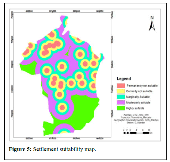
Proximity to Settlement
Human interference is one of the most problems that disturb the conditions of much wildlife including of the Ethiopian wolves. According to General Management Plan of Bale Mountains National Park (2017) settlements are increased in all areas of the park including the remote and inhospitable areas of afroalphine and Harenna forest. As a result, the habitats are more profoundly modified by human population.
Ethiopian wolves are not suitable in living with the closest of human settlement. Hybridization with feral dogs is one of a problem presently facing the wolf species. Additionally, rabies is another factor that happens due to the existence of settlement in and around the park whereby it transferred from the dogs to them. And another impact like noise, visual (human sight), land use etc. leads to encroachment of wolves (Figure 5).
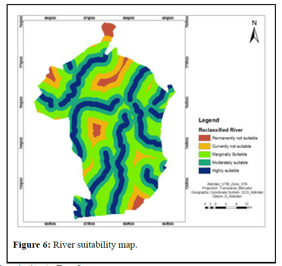
Proximity to River
Water is one of the life supporting systems that allows all living things to survive on the surface of the earth. It’s a crucial life requirement for every species including Ethiopian wolves. The suitable habitat for wolf species is near to the rivers.
According to the ecologists of Frankfurt zoological society, Ethiopian wolf round in one day approximately in 25 km2 area for the sake of finding their basic needs. So that, the suitable habitat for the Ethiopian wolf species is recommended if water is available in 25 km2 area.
As result the area found within 5 km distance to the river termed as a suitable region for Ethiopian wolf habitat (Figure 6).
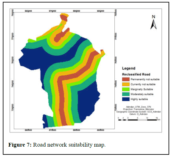
Proximity to Road
Accessibility is an important infrastructure with regard to tourism development and it is a good access for tourists to visit this endemic species. An area closest to the road network is not good for the wolf habitat because of road kills and disturbance is there. As a result, there must specific distances were masked for the purpose of their safety (Figure 7).
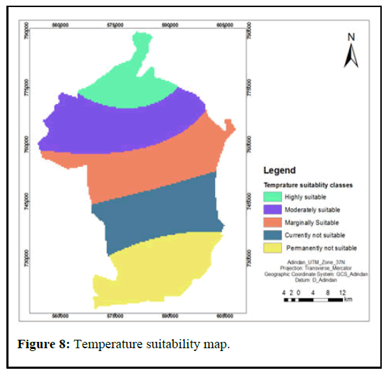
Temperature
Temperature of the study area was selected as a factor for habitat suitability analysis of Ethiopian wolf species. Bale Mountains National Park is a park which constitutes a large area with remarkable elevation gradient. As a result, the park is characterized by large variation in the temperature. Alpine is colder and broadly corresponds with the distribution of habitats suitable for the wolves. Ethiopia wolves are an afroaphine cold temperature adopted of Ethiopian highlands (Figure 8).
Rainfall
As a result of the great altitudinal variation in Bale mountains massifs, considerable variations of climatic conditions are recorded in the Park. The Bale Mountains is characterized by having eight months rainy season March to October and followed by another four months dry season November to February [15].
According to information gathered from the Ethiopian Wolf Conservation Programme through interview, Rainfall is an important factor should be considered in the process of habitat suitability analysis for Ethiopian wolves. Because, directly precipitation conserve soil moisture which support burrowing activity and indirectly, precipitation leads to existence of grasses which is crucial for availability of rodents (Figure 9).
Weight Assigning
The reclassified layers were combined in order to select suitable habitat sites for Ethiopian wolves (Canis simensis) in the study area. All factors cannot have equal preferences as a result; weighting was used to express the importance or preference of each factor relative to other factor. Accordingly, nine factors were standardized and computed by using of IDRISI 17 software to produce their weights (Table 1).
| Factors | Lu/Lc | El. | Rv. | So. | St. | Tp. | Rd. | RF. | Sl. | Weight | Weight (%) |
|---|---|---|---|---|---|---|---|---|---|---|---|
| Lu/Lc. | 1 | 0.234 | 23 | ||||||||
| El. | 44593 | 1 | 0.195 | 20 | |||||||
| Rv. | 44621 | 44593 | 1 | 0.14 | 14 | ||||||
| So. | 44593 | 44593 | 44593 | 1 | 0.116 | 12 | |||||
| St. | 44621 | 44621 | 44593 | 44593 | 1 | 0.089 | 8 | ||||
| Tp. | 44621 | 44593 | 44621 | 44593 | 44593 | 1 | 0.078 | 8 | |||
| Rd. | 44593 | 44682 | 44621 | 44621 | 44593 | 44593 | 1 | 0.058 | 6 | ||
| RF. | 44621 | 44621 | 44593 | 44593 | 44621 | 44621 | 44593 | 1 | 0.053 | 5 | |
| Sl. | 44682 | 44682 | 44621 | 44621 | 44593 | 44593 | 44593 | 44621 | 1 | 0.035 | 4 |
| Totals | 1 | 100 |
Consistency Ratio (CR)=0.05
Table 1: Weights of the factors using pairwise comparison matrices.
Where:
Lu/Lc.=Land use Land Cover, El.=Elevation, Rv.=River, So.=Soil, St.=Settlement, Tp.=Temperature, Rd=Road, RF.=Rainfall and Sl.=Slope.
Consequently, weighted overlay tool in the ArcGIS spatial analyst extension was used to combine all factors according to their rank and weight that has been computed from the pairwise comparison matrix to select the intended outcomes for suitable habitat of Ethiopian wolves in the study area (Figure 10).
As it is shown on the above map (Figure 10), the area which indicated by fire red and ultra-blue colors are highly suitable and moderately suitable for the habitats of Ethiopian wolf. These areas are found around Sanetti and Weyb valley in Bale Mountains National Park. The solar yellow color on the map represents the area marginally suitable for habitat of wolves. The remaining lands showed on the map by peony pink and cyan are found areas which are currently not suitable and permanently not suitable for Ethiopian wolf’s habitat respectively. From the total study area 65.7% were found as suitable for Ethiopian wolf species habitat. These are areas which fulfill the requirement for habitats based on the factors those analyzed in the study.
In similar manner, this area has been suggested to be a suitable habitat range for Ethiopian wolf species. From these, Weyb valley and Sanetti plateau are the optimal habitat for the species from the Bale Mountains National Park perspective. Additionally, the map and statements published by IUCN/SSC (2011) on the strategic plan for Ethiopian wolf conservation showed that similar geographic location with the map produced in this study.
The remaining, 34.3% of the study area was found as not suitable for habitat of Ethiopian wolf species. These were areas failed to fulfill the life requirement for habitat of Ethiopian wolf species.
Discussion
Bale Mountains National Park is one of the protected areas in southeastern Ethiopia with the large areas of continuous Afroalpine and Afromontane forest habitats and it support several species that are often considered to be threatened and endangered mammals like Ethiopian wolf species. Ethiopian wolves are one of endangered endemic canid species of Ethiopia and registered on the IUCN Red List of Threatened Species.
The intention of this study was to analyze habitat suitability for Ethiopian wolf (Canis simensis) species through employing Geographic Information Systems and Multi Criteria Decision Analysis at Bale Mountains National Park.
Conclusion
In this study, nine environmental factors were used to generate suitable habitat map of the study area include temperature, rainfall, elevation, slope, land use/land cover, soil, rivers, roads and settlements. Geographic Information Systems and Multi Criteria Decision Analysis method was employed to identify suitable habitat sites. Factor Maps were generated for all variables, after the reclassification of all factors based on their suitability importance for habitat.
Weights for each criterion were assigned based on AHP using pairwise comparison matrix and the Consistency Ratio (CR) was calculated and it was found within acceptable limits. Then weighted overlay was undertaken to produce the habitat suitability map based on their Eigenvector value.
The findings of this study have shown that, the Northern, Northwestern, Northeastern and central part of the Park were found more suitable for Ethiopian wolves due to the existence of important environmental factors that are the necessary conditions for their living. The areas are characterized by High elevation above 3,000 m with alpine bush lands, open areas with short herbaceous and grasslands, flat or gently sloping with deep soils and cold temperature.
The southern part of Bale Mountains National Park was found to be unsuitable for Ethiopian wolves’ habitat due to the presence dense forest (Harenna forest); moderate temperature and elevation of the land scape were found unsuitable for Ethiopian wolf species.
Recommendations
Based on the findings of the study, the following recommendations are suggested:
• Ethiopian wolf habitat suitability maps can be used as a tool for wildlife conservation and planning related habitat based programs.
• The wildlife potential areas identified in this study should be protected and Awareness should be created for the local community who live in and around the park by considering the prior areas to get special management emphasis.
• Ethiopian wolf is an endangered species. Therefore, it’s recommended that further research should be carried out by considering more factors and multiple techniques in order to improve the existing conservation and management conditions.
Disclosure Statement
The authors declare that there is no conflict of interests regarding on the publication of this paper.
References
- Brooks Thomas M, Russell A Mittermeier, Cristina G Mittermeier, Gustavo AB Da Fonseca, Anthony B Rylands, et al. (2002) Habitat loss and extinction in the hotspots of biodiversity. Conserv Biol 16: 909-923.
- Dirzo R, Raven PH (2003) Global state of biodiversity and loss. Annu Rev Environ Resour 28: 137-167.
- Evangelista PH, Norman III J, Swartzinki P (2012) Assessing habitat quality of the mountain nyala Tragelaphus buxtoni in the Bale Mountains Ethiopia. Curr Zool 58: 525-535.
- Gashaw T (2015) Threats of bale mountains National Park and solutions, Ethiopia. J Phy Sci Env Stud 1: 10-16.
- Gottelli D, Sillero-Zubiri C (1992) The Ethiopian wolf-an endangered endemic canid. Oryx 26: 205-214.
- Greaves GJ, Mathieu R, Seddon PJ (2006) Predictive modelling and ground validation of the spatial distribution of the New Zealand long-tailed bat (Chalinolobus tuberculatus). Biol Conserv 132: 211-221.
- Hauer A, De Cruz K, Cochard T (2015) Genetic evolution of Mycobacterium bovis causing tuberculosis in livestock and wildlife in France since 1978. PloS one 10: e0117103.
- Imam E, Tesfamichael GY (2013) Use of remote sensing, GIS and Analytical Hierarchy Process (AHP) in wildlife habitat suitability analysis. J Mater Environ Sci 4: 460-467.
- Lenton SM, Fa JE, Del Val JP (2000) A simple non-parametric GIS model for predicting species distribution: endemic birds in Bioko Island, West Africa. Biodivers Conserv. 9: 869-885.
- Mamo Y, Bekele A (2011) Human and livestock encroachments into the habitat of Mountain Nyala (Tragelaphus buxtoni) in the Bale Mountains National Park, Ethiopia. Trop Ecol 52: 265-273.
- Marino J (2003) Threatened Ethiopian wolves persist in small isolated Afroalpine enclaves. Oryx. 37: 62-71.
- Myers N, Mittermeier RA, Mittermeier CG (2000) Biodiversity hotspots for conservation priorities. Nature 403: 853-858.
- Sih A, Jonsson BG, Luikart G (2000) Habitat loss: ecological, evolutionary and genetic consequences. Trends Ecol Evol 15: 132-134.
- Sillero-Zubiri C, King AA, Macdonald DW (1996) Rabies and mortality in Ethiopian wolves (Canis simensis). J Wildl Dis 32: 80-86.
- Stephens PA, d'Sa CA, Sillero-Zubiri C (2001) Impact of livestock and settlement on the large mammalian wildlife of Bale Mountains National Park, southern Ethiopia. Biol Conserv 100: 307-322.
Citation: Tekalign K, Alemu M, Gidey G (2022) Geographic Information Systems and Multi Criteria Decision Analysis Based Habitat Suitability Analysis for Ethiopian Wolf (Canis simensis) Species at Bale Mountains National Park, Ethiopia. J Ecosys Ecograph 12: 317. DOI: 10.4172/2157-7625.1000317
Copyright: © 2022 Ketema T, et al. This is an open-access article distributed under the terms of the Creative Commons Attribution License, which permits unrestricted use, distribution, and reproduction in any medium, provided the original author and source are credited.
Select your language of interest to view the total content in your interested language
Share This Article
Recommended Journals
Open Access Journals
Article Tools
Article Usage
- Total views: 2261
- [From(publication date): 0-2022 - Oct 20, 2025]
- Breakdown by view type
- HTML page views: 1686
- PDF downloads: 575

