Research Article Open Access
Geochemical Evidence for Provenance, Tectonic Settings and Presence of Gas Hydrate in Mud Volcano Sediments of Andaman Islands
Vignesh A*, Ramanujam N, Rasool Q and Swapan KB
Department of Disaster Management, Pondicherry University, Andaman Islands
- *Corresponding Author:
- Vignesh A
Department of Disaster Management
Pondicherry University, Andaman Islands
Tel: +91 9434263194
E-mail: vignesh@live.com.sg
Received December 10, 2015; Accepted January 28, 2016; Published February 28, 2016
Citation: Vignesh A, Ramanujam N, Rasool Q, Swapan KB (2016) Geochemical Evidence for Provenance, Tectonic Settings and Presence of Gas Hydrate in Mud Volcano Sediments of Andaman Islands. Oil Gas Res 2:111. doi:10.4172/2472-0518.1000111
Copyright: © 2016 Vignesh A, et al. This is an open-access article distributed under the terms of the Creative Commons Attribution License, which permits unrestricted use, distribution, and reproduction in any medium, provided the original author and source are credited.
Visit for more related articles at Oil & Gas Research
Abstract
Abstract Mud volcanoes are one of the land / seafloor expressions of the expulsion of argillaceous material from deeper areas, generated by an extrusion activity involving the transfer of sediments, liquids and gas from subsurface to the land / seafloor. Eruption of mud volcano has been recorded historically in 1843, 1879, 1907, 1983, 2003, and 2004 in Bara tang in Middle and Diglipur in North Andaman Islands. Exceeding of threshold pressure of pressured gas and/ or liquid breaks upward through the overlying sediment frequently following existing zone of weakness and flow out sub aerially or subaqueous condition. Venting structure of mud volcanoes are the most important natural seepage features with fluid, gases and sediments from the earth’s surface. Most of the terrestrial mud volcanoes are located in convergent plate margin with thick sedimentary sequences as seen in Alpine-Himalayan, Caribbean and Pacific organic belts. The occurrence of mud volcanoes is controlled by several factors, such as tectonic activity, sedimentary loading due to rapid sedimentation and the existence huge thickness of fine-grained sediments and continuous hydrocarbon accumulation. Tectonic setting discrimination diagrams based on major, minor and trace elements suggest a shale provenance in an oceanic island arc. The correlation of K2O with other elements, abundance of Al2O3, Ba, Th suggest that these elements are primarily controlled by the dominant clay minerals. The compositional immaturity of the analyzed mud volcano sediments is typical of sub ducted-related environments, and their SiO2/Al2O3 and K2O/Na2O ratios reflect their oceanic island arc settings.
Keywords
Mud volcano; Gas hydrates; Tectonic provenance; Tectonic setting; Andaman islands
Introduction
Mud volcanoes are the world’s most dynamic unstable sedimentary structures and their geomorphic expression at the surface vary significantly. A variety of geomorphological expressions of mud volcanoes have been identified from different parts of the world in the onshore and offshore [1-3]. The typical and simplest morphology of mud volcanoes is represented by a cone with a summit crater. Their size and shape vary in relation to the nature [viscosity, density, grain size] of the emission products, the nature and frequency [slow, rapid, or even explosive] of the emissions, and the volumes of the material and fluids produced [3,4]. Mud volcanoes typically emit a mixture of gas, water, and sediment derived from deep seated rocks. The nature and relative proportions of these products affect the shape and size of the surface feature of mud volcanoes [3-5]. The main component of the emission products of a mud volcano are in the form of a liquid mud containing clasts [mud breccia] and gases. Individual fragments, which may be angular or rounded, range in diameter from a few millimetres to boulders, derived from different stratigraphic layers, from greater depths. Hydrocarbons are the dominant gases [mainly methane] emitted by the mud volcanoes, which might have been generated by microbial or thermogenic origin [5]. Methane emissions from mud volcanoes may be partly associated to methane-dependent biological habitats, around the feeder of the mud volcano Mud volcanoes have been identified on seismic sections as vertical features, with a seismically transparent or chaotic internal character, which disrupt or pierce through sediment strata. Collier and White [6] suggested possible explanations for the seismic transparency: the physical disruption of the sediment layers, ‘overwriting’ of the layering by concentrations of gas, and/or acoustic signal starvation caused by the presence of gas, gas hydrates, or methane derived authigenic carbonates at or near the seabed. Many of the mud volcanoes show a typical “Christmas Tree” structure on reflection seismic cross sections due to the stacking of mud flow edifices suggested by [7-9] but not all of them. Due to its internal structure, the mud volcanoes in Andaman Island are referred to as a sedimentary diatreme [10]. Besides the visible surface feature [cone and crater], mud volcanoes have a subsurface feeder pipe or channel that may have subsidiary feeder pipes, which determine its plumbing system. Normally, the feeder pipes are not single entities feeding an individual mud volcano but instead show a composition of feeders [11]. Mud volcanoes are common features in fore arc region. Apart from the main fault of the subduction zone, i.e. the decollement fault along which the two plates come into contact, there exist numerous faults along the convergent margin. Some of these faults acts as pathway and play an important role in the formation of mud volcanoes. These faults help to release high pressurized gas along with fluidized solid materials from the subduction zone through deep conduits and serve as a window of subducting slab. The diameter of mud volcanoes ranges from a few centimeters to several meters; predominantly locate in areas of tectonic compression like the subduction zones. Seismic pumping is the main factor that enhances the ejection of mud, water and gas to form mud volcanoes.
The conditions for the development of mud volcanoes [1]
• Thick sedimentary deposits with rapid sedimentation of argillaceous materials.
• The presence of plastic stratum in the subsurface.
• Availability of over pressured sedimentary formation to generate hydrocarbon.
• Sediments deposits associated with tectonic shortening and/or earthquake activity to enhance dehydration.
• Fluid emissions of gas, brines, water retrieved from mineral dehydration sources to increase the gas hydrate dissociation.
• Compressional faults and active tectonic settings are necessitating for clustering of mud volcanoes.
• For ease ejection of argillaceous mud fraction in the mud volcanoes, polymictic assemblages of the rock fraction are essential.
As the present study area is located on the sites of the collision plates, where abnormal pore fluid pressure are developed due to expanding gases trapped inside the plastic clays and other internal processes. The geochemistry of the mud volcano sediments provide important information about the sediments of subducting slab along with composition of deep seated series and can be used for revealing the evolution of the Andaman subduction zone. The geochemical analysis can also hint for the nature of their source, provenance, tectonic settings and weathering conditions. Some researchers emphasized that major element geochemistry of the sedimentary environments are more useful in discriminating the tectonic setting [12,13]. However, Armstrong- Altrin and Verma [14] have warned against an indiscriminate use of discrimination diagrams for provenance studies using major element geochemistry. The trace elements such as La, Sc, Cr, Th, Zr, Hf and particularly TiO2 among the other major elements are best suited for provenance and tectonic setting discriminate studies, because of their relatively low mobility during sedimentary process [15]. Weathering conditions have been inferred by application of a variety of chemical indexes based on abundances of major elements [16].
Geological Setting of Andaman Islands
The tectonic evolution of Andaman and Nicobar Islands has been modelled on the basis upon the following component such as i] tectonic features noted from the Sea floor [17]. ii] seismic records [18] and iii] regional correlation of tectonic elements of the eastern part of the Himalaya [19]. The history of subduction in the central part of Sunda arc has been a matter of debate. There exist two schools of thoughts. The first school Acharyya et al., [20] argues that the present subduction, all around the western Sunda arc, began during Miocene times and onland emplacement of Ophiolites took place during terminal collision in Oligocene times. In their model, a second trench further east of the present trench with a proto continent was assumed. Also, Cretaceous Ophiolites and Eocene sediments were considered as a part of this accretionary prism related tNo second subduction margin and believed to have subsequently emplaced as east to west propagating allochthonous nappe sheets on present subduction margin. The second school of thought is based on the presence of melange and the highly deformed sediments. These authors suggest that the onset of subduction took place during Late Cretaceous times, after the early break-up of the Gondwanaland during Cretaceous Curray [17] or from Late Palaeozoic period [21,22]. The currently accepted stratigraphy of the Andaman Islands is based on the earliest lithological mapping done by Oldham [23]. Who first divided the rocks of Andaman into two parts; older Port Blair series and younger Archipelago series, separated by volcanic rocks and serpentines, later recognized as an Ophiolites sequence. In 1960s paleontological constraints were used to identify the Paleocene-Neogene lithostatigaphic units and subsequently in last five decades the stratigraphy has been modified and formation names have been changed. Allen et al. [24] divided the Andaman Island stratigraphy into four groups. Accordingly, the present stratigraphy now comprises of four units, which, in ascending order, are the Ophiolites Group, the Mithakhari Group, the Andaman Flysch Group, and the Archipelago Group.
Ophiolite group
The Ophiolite Group forms the basement of the Andaman Islands, a part of the Indo-Burma accretionary complex. It contains numerous north-south trending slices of Cretaceous-Palaeocene Ophiolites. The group is made up of a plutonic complex, a volcanic sequence and pelagic sedimentary rocks. Pal and Bhattacharya [25] developed regional Ophiolites stratigraphy on the basis of local contact relationships. They reported that the lower part of the group [80% of the total outcrop] comprises foliated and highly serpentinized peridotite. The upper part comprises a layered sequence of ultramafic-mafic rocks, and intrusive section of homogenous gabbro-plagiogranite-diorite - dolerite and an extrusive section of boninite and tholeitic basalt lavas. Although Ophiolite occurrences are reported from almost all the major Andaman Islands, but the largest volume of mantle sequence is exposed in Middle and North Andaman Islands Pal [25]. The age of Andaman Ophiolites and the timing of their obduction remain controversial. In a couple of studies recently, two independent groups of researchers, dated zircon from plagiogranites of the Ophiolite Group from south Andaman by U-Pb dating method, and suggested that the formation age of these could not have been younger than~95 Ma [26]. These workers also suggested that the new age of Andaman Ophiolites is similar to that of the Oman and Troodos, Cyprus Ophiolites and that it extends the range of Late Cretaceous Ophiolite formation along the Tethyan suture zones from the Mediterranean to the Andaman Sea. The similarity in age between the Troodos, the Oman and now the Andaman Ophiolite seems best explained by a suprasubduction zone origin Pal [27].
Mithakhari group
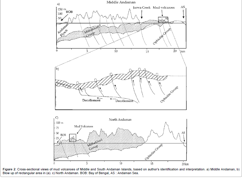
Karunakaran [28] was the first geologist who introduced the term Mithakhari Group. The thickness of this sedimentary unit is ~1.4 km, and is divided into three formations Ray [28]: i] the Lipa Black Shale, ii] the Hope town conglomerates and iii] the Namunagarh Grit. The Lipa black shale is a minor unit with very limited exposures [29]. The rocks in this group consist of immature gravels, pyroclastic sandstones, polymictic conglomerates and thin bed shales, mudstones and coal. Pal et al. [30] recognized eight different lithofacies in these formation on the basis of the bed geometry and recorded sedimentray structures. These lithofacies include disorganized and graded matrix supported conglomerate, graded pebbly sandstone, interbedded sandstone and mudstone, massive to faintly laminated shale and interbedded shale and coal. The conglomerates contain clasts of quartz vein, lithic shale fragments, limestones, sandstones, cherts, ultramafic rocks, porcellinite and basalts. The shale facies consist of massive to laminated pyritiferous shale interbedded with silt/fine sandstone. Apart from above a number of mud volcanoes are also reported in the Middle and North Andaman Islands in shale dominated facies of the Mithakhari Group (Figure 1).
Andaman Flysch
The Andaman Flysch Group along with the Archipelago Group are deposited in a forearc environment. The Andaman Flysch Group overlies the Mithakhari Group and underlies the Archipelago Groups. The Andaman Flysch Group is a siliciclastic turbidite sequence which most completely exposed in South Andaman.
Archipelago group
Archipelago Group represents the topmost stratigraphic unit of the Andaman accretionary prism. The deposition of the unit was believed to have taken place mostly in a slope environment Roy [31]. The lower members of this group comprise basal conglomerates and sandstones, overlain by calcareous arenites of the Strait Formation. On the basis of Radiolarian and planktonic forminiferas and calcareous nano fossils form John Lawrence Island Singh et al. [32] reported depositional ages for this group in the range of 18.3-15.6 Ma, but Pal et al. [33] has argued for a younger age.
Study of Mud Volcanoes in Andaman Islands
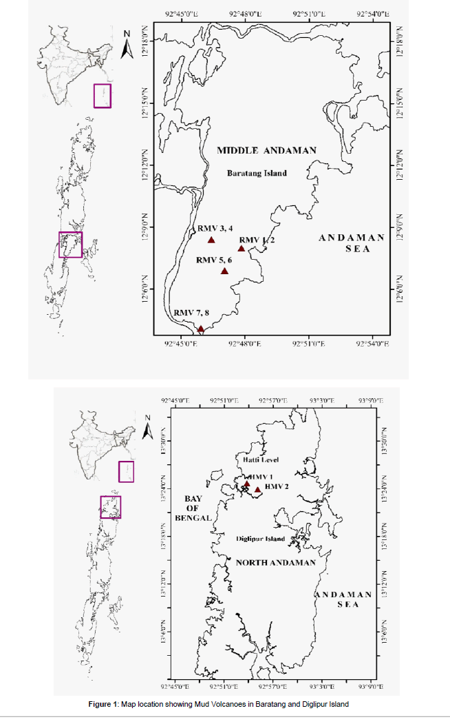
The eruption of mud volcanoes and throwing of mud above the height of the surrounding trees have been witnessed in Baratang Island of the Middle Andaman, and from Diglipur Island in the North Andaman at the time of 2004 Great Sumatra - Andaman Earthquake with Mw 9.3 Geological Survey of India [34]. Present study is concentrated over mud eruption spread over in the areas at Rajathgarh, [N12Ã?Â?07 19.76 E92º45 37.52] Pusi [N12º047 20.35 E92º76 01.26] and at Mirchtikkri [N12º0746.82 E92º47 31.23] at Baratang Island and Hatti Level [N 13°24.894’, E 92°53.579’] at Diglipur (Figure 2). These mud volcanoes are located along fault zones trending mainly in NE-SW at Baratang and NNW-SSE direction at Diglipur. The NE-SW aligned faults are part of the imbricated thrust sheets that dip eastward, parallel to trench axis of the subduction zone. The diapiric ascent of fine sediments pierced through these faults is believed from compressional forces resulting from overthrusting Badve et al. [35] Ling et al. [36]. These thrust faults provide the pathways for the material transport pierced through the accretionary wedge to form the mud volcanoes at the surfaces. These faults are probably from the continuation of East Margin Fault Curray [37] and extended further north as the Jarawa Thrust Fault. Mud volcano eruption at Baratang and Diglipur was observed in February 2003. A minor fissure eruption was also recorded at the same site before 1983. This type of fissure eruption are common in Baratang Island, where mud and gases are constantly seeping out. Subsequently major eruptions have been reported in March 1983 and December 2004. The eruption of mud has covered vast area and forming of circular mound more than 30 m in diameter and 2 to 3 m in height at centre. The main crater is submerged under the grey coloured solidified mud. The ejected mud contains angular and sub rounded rock fragments of sandstone, red and green shale fragments, serpentine and Ophiolites. The colourless gas is constantly emitting from the mud volcanoes. The analysis of the constitution of the gas reveals the following gases CH4 [55.7 vol. %] followed by N2 [32.2%], O2 + Ar [9.9%], CO2 [2.0%] and He [0.2%] at Baratang Island. Volcanic glass, brines, and sulfide nodules in addition to the dominant illite and kaolinite were reported in the mud volcanoes in Baratang Island, Jarawa Creek and the mud volcano of Diglipur Island [38]. Before the major earthquake the eruption from fissure mud volcano were observed at many places in middle Andaman. Mud volcano near the Jarawa creeks at middle Andaman erupted with loud explosive noise before the 2004 major earthquake. Individual mud volcano are observed with various size and shape in the areas of Rajatgargh, Katan and Mirchitikiri in Baratang Island and Hatti level in Diglipur Island. About 13 and 11 active mud volcanoes are identified at Baratang and Diglipur Islands. The eruption of mud volcanoes along the cracks / fissures are oriented in NE-SW direction in Baratang Island and NW-SE direction in Diglipur Island. Mud volcanoes in these area erupted with various sizes of sedimentary rocks and Ophiolites group of rocks along with mud fractions. Mud breccia in the study area are easily related to the regional geology and the clay or shale bearing lithology at depth. It is clearly seen that the mud volcanoes in these regions are acting as a tectonic windows for visualization of various types of rock material present at the deeper level. From these observation, it is seen that the sources of mud volcanoes such as liquid, gases and sedimentary clast had been derived from the various depth and sources. Since the study area of the Baratang and Diglipur Island are in the close proximity to oblique subduction zone due to tensional and transtenstional tectonics grooming of mud volcanoes in Baratang and Diglipur been evolved due to the proximity of these sites very closer to oblique subduction zone.
Geomorphology of Mud Volcano
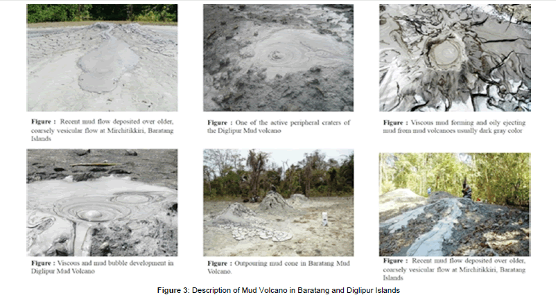
Andaman and Nicobar Islands are experiencing heavy rainfall of 3000 to 4000 mm/year. So rainfall washed all the mud volcano features and geometrical shaped. After the rainfall, once again the mud volcano starts from the beginning to build then shape and increase their sizes. Analysis of morphological features of the various craters in the study area reveal that there was no permanent existence of single crater continued in the past. The thick accumulation of the erupted mud around the edifice of the mud volcanoes increases the height and change the shape into conical shape. The craters changed configuration and resulted in several small satellite cones. Most of the crater of the mud volcanoes are subsequently submerged due to the invasion of the other crater. Conical, plano convex and concave collapse structure of mud volcano are observed in Hatti Level in Diglipur. The conical shaped mud volcano ejects thick mud flow with gases matter than the water. The plano convex shaped mud volcano ejects more equal proportion of mud, gas and water. This type of mud volcanoes are located in Baratang and Diglipur. The mud volcano of concave collapse structure at Diglipur ejects more of water than mud and gases. This type of mud volcano can be called as a new volcano which is ejecting high amount of water due to overpressure. However, some of the mud volcanoes at Diglipur regions erupt voluminous low viscous mud flows very frequently and spread over the surface area are certainly hazardous for human beings and animals. The shape of mud volcano feature at Diglipur area reflects some extent, that physical properties of the extruded materials as more viscous have to ultimately increase the width of the conduit in order to facilitate for eruption. Whereas the mud volcanoes at Baratang are found as more fluidity and eruptions are spread out easily so that width of the conduit has not been increased. Surface expression of the mud volcano is variable and depend primarily on the mud fluid content and extrude mud. Mud with low viscosity form cohesive mud with fluid content can give rise to mud volcano. The extrusion of mud flow with various shape and size at Diglipur differs from the Baratang mud volcanoes. Sometimes the craters of the peripheral cones of the mud volcanoes are covered with overflows. The mud volcano contains bubbles with erupted gases. The ejection of mud in Diglipur mud volcano is accompanied by an unusual gurgling sound which is not heard at Baratang mud volcanoes. If a stone is hurled into the mud reservoir, a weird and bizarre sound echoed through the air. Mud volcano which erupts violent and noisy effusion of mud. The mud volcano had unexpectedly become dormant. Sometimes an inactive crater rejuvenates its activities and also active crater become inactive at some places. The volume of erupted materials from the mud volcanoes of Diglipur are comparatively more than the Baratang mud volcanoes (Figure 3).
Methods
Geochemical characterization of mud sediments to describe the various geochemical, geodynamic and sedimentological parameters such as provenance, tectonic setting, and conditions of formation and sources of weathering. 8 mud samples from Baratang Islands and 7 mud samples from Diglipur Islands were collected. During this study, proper care was taken to avoid any metal contamination while powdering the samples. Prior to powdering sample were thoroughly cleaned [repeatedly with HCl and Ethyl alcohol]. Powdering was done using agate mortar and pestle. The samples were powdered to less than75 micron size [200 mesh.], homogenized and stored in plastic bottles. The major oxides [SiO2, TiO2, Al2O3, Fe2O3, MnO, MgO, CaO, Na2O, and K2O and P2O5] were analyzed using X- Ray Fluorescence [XRF] spectroscopy method (Tables 1 and 2).
Results
The mud volcanoes in the Baratang and Diglipur in the vicinity of fault have become active and erupted huge amount of mud flows at the time of Great earthquakes . Seismicity reactivated the mud volcanoes and erupted the muds along the faults as conduit. Over pressured multiphase pore fluids mainly water and methane are incorporated to make the mud as a semi - liquid and forced up through fissures in the crust and producing an out flowing mass of mud on the surface. Due to the effects of tectonic activity, geological structures of Andaman Island are largely oriented in N -S direction. Furthermore, the intense mountainbuilding activity, faulting and folding have occurred throughout the Island. Paleogene extensional fault system [NW- SE, N-S and NE-SW direction] and Neogene [Upper Miocene] compressional fault system oriented in NE-SW direction. These mud volcanoes are located along fault zones trending mainly in NE-SW direction in Baratang Island and NW-SE direction in Diglipur Island. The N-S aligned faults are part of the imbricated thrust sheets that dip eastward, parallel to trench of the subduction zone. The diapiric ascent of fine sediments through these faults is believed to be due to post-Eocene compressional forces resulting from over thrusting Badve and Ling [35,36]. These thrust faults provide the pathways for the material in the accretionary wedge to come up through the mud volcanoes. The most favourable source rock for formation of mud volcano in the Late Cretaceous-Late Eocene age, comprising of shale, silt, sand, carbonaceous shale, limestone belonging to Mithakhari Group of rocks The free gas diffusion through clay or silt as a function of the median pore and kinematic diameter of gas molecules has developed ‘shale gases ’even over impermeable shale section [39]. The amplification of overburden pressure owing to accretionary wedge setting and thrusting of off scraped material in Andaman Sliver Plate enhanced the pathways for migration of fluids through the system. Strain hardenings at depth [2.5-3 km] furnish a characteristic scaly fabric to mud for migration of gas saturated brine. While, the strain softening of these formation in the upper part [1.0- 1.5 km] has allowed dissolved gas to rapid expansion as it comes out of solution and developed migration pathways to the surface through lines of weakness prevailed to extensional tectonic over the top of the underlying diaper Ware and Ichram [40]. The overpressure which gives rise to the mud volcanism also causes increased expulsion efficiency. In the clay rich sediments the hydrate may occur in veins or fracture and be better represented by HS upper bound where resistive material occur in sheets impeding currents flow through the matrix fluid.
| RMV - 1 | RMV - 2 | RMV - 3 | RMV - 4 | KMV - 5 | KMV - 6 | MMV - 7 | PMV - 8 | |
|---|---|---|---|---|---|---|---|---|
| Major elements oxide, and LOI compositions (%) | ||||||||
| SiO2 | 54.77 | 54.46 | 53.55 | 54.18 | 53.96 | 54.65 | 53.75 | 54.37 |
| TiO2 | 0.79 | 0.77 | 0.76 | 0.77 | 0.76 | 0.76 | 0.77 | 0.76 |
| Al2O3 | 18.47 | 18.39 | 18.41 | 18.49 | 18.51 | 18.71 | 18.48 | 18.82 |
| Fe2O3 | 6.31 | 6.24 | 6.24 | 6.2 | 6.23 | 6.11 | 6.28 | 5.96 |
| MnO | 0.05 | 0.05 | 0.05 | 0.06 | 0.06 | 0.05 | 0.05 | 0.05 |
| MgO | 2.33 | 2.5 | 2.46 | 2.53 | 2.57 | 2.55 | 2.52 | 2.53 |
| CaO | 0.82 | 0.93 | 0.99 | 0.92 | 0.89 | 0.87 | 0.9 | 0.7 |
| Na2O | 1.93 | 2.06 | 2.21 | 2.01 | 2.06 | 1.95 | 2.04 | 1.94 |
| K2O | 2.36 | 2.26 | 2.18 | 2.27 | 2.3 | 2.32 | 2.31 | 2.53 |
| P2O5 | 0.09 | 0.1 | 0.1 | 0.1 | 0.1 | 0.11 | 0.09 | 0.11 |
| LOI | 11.22 | 11.79 | 12.79 | 12.32 | 12.10 | 10.96 | 12.54 | 11.77 |
| Total | 99.14 | 99.55 | 99.74 | 99.85 | 99.54 | 99.04 | 99.73 | 99.54 |
| Elemental Abundance (ppm) | ||||||||
| V | 156 | 154 | 157 | 157 | 156 | 156 | 161 | 156 |
| Cr | 141 | 133 | 142 | 142 | 138 | 142 | 140 | 131 |
| Co | 29 | 74 | 38 | 38 | 36 | 33 | 59 | 41 |
| Ni | 84 | 79 | 85 | 87 | 89 | 86 | 90 | 84 |
| Cu | 38 | 40 | 41 | 40 | 43 | 40 | 41 | 40 |
| Zn | 84 | 82 | 83 | 81 | 85 | 110 | 91 | 80 |
| Ga | 17 | 15 | 17 | 17 | 2 | 17 | 18 | 18 |
| Rb | 83 | 74 | 77 | 80 | 1 | 83 | 86 | 92 |
| Sr | 165 | 131 | 142 | 139 | 0 | 137 | 150 | 141 |
| Y | 26 | 23 | 24 | 26 | 20 | 26 | 26 | 26 |
| Zr | 177 | 155 | 169 | 168 | 18 | 176 | 174 | 181 |
| Nb | 10 | 10 | 10 | 10 | 12 | 11 | 11 | 11 |
| SC | 22 | 20 | 20 | 21 | 85 | 22 | 22 | 19 |
| Cs | 4 | 3 | 2 | 6 | 139 | 4 | 10 | 6 |
| Ba | 288 | 232 | 227 | 254 | 26 | 268 | 231 | 288 |
| La | 17 | 15 | 18 | 16 | 174 | 12 | 15 | 21 |
| Ce | 67 | 58 | 61 | 57 | 10 | 65 | 60 | 74 |
| Mo | 2 | 2 | 2 | 2 | 1 | 2 | 2 | 2 |
| Sn | 1 | 4 | 2 | 1 | 250 | 1 | 3 | 1 |
| Sb | 0 | 0 | 0 | 0 | 12 | 0 | 0 | 0 |
| As | 13 | 12 | 12 | 11 | 61 | 10 | 14 | 14 |
| Pb | 21 | 16 | 17 | 18 | 0 | 17 | 20 | 21 |
| Nd | 0 | 0 | 0 | 0 | 0 | 0 | 0 | |
| Ta | 0 | 0 | 0 | 0 | 0 | 0 | 0 | |
| Hf | 0 | 0 | 0 | 0 | 0 | 0 | 0 | |
| Th | 8 | 7 | 7 | 8 | 7 | 8 | 9 | |
| U | 2 | 2 | 1 | 2 | 1 | 2 | 2 | |
Table 1: Concentrations of the major element oxides and Trace element composition of Mud Volcano, in Baratang, Middle Andaman Islands.
| DMV - 1 | DMV - 2 | DMV - 3 | DMV - 4 | DMV -5 | DMV - 6 | DMV - 7 | |
|---|---|---|---|---|---|---|---|
| Major elements oxide, and LOI compositions (%) | |||||||
| SiO2 | 55.23 | 54.52 | 55.12 | 54.66 | 54.59 | 61.07 | 55.59 |
| TiO2 | 0.78 | 0.76 | 0.78 | 0.78 | 0.08 | 0.72 | 0.78 |
| Al2O3 | 18.56 | 18.45 | 18.05 | 18.05 | 18.16 | 14.03 | 17.87 |
| Fe2O3 | 6.16 | 6.01 | 6.31 | 6.15 | 6.3 | 5.57 | 5.98 |
| MnO | 0.05 | 0.05 | 0.08 | 0.06 | 0.06 | 0.05 | 0.06 |
| MgO | 2.35 | 2.46 | 2.35 | 2.32 | 2.37 | 1.78 | 2.41 |
| CaO | 0.91 | 0.98 | 0.89 | 0.91 | 1.12 | 1.1 | 1.08 |
| Na2O | 1.78 | 1.87 | 1.95 | 2.1 | 1.95 | 2.14 | 1.98 |
| K2O | 2.33 | 2.43 | 2.29 | 2.41 | 2.49 | 1.59 | 2.49 |
| P2O5 | 0.1 | 0.1 | 0.09 | 0.11 | 0.11 | 0.11 | 0.1 |
| LOI | 10.69 | 11.62 | 11.12 | 12.15 | 11.17 | 10.8 | 10.69 |
| TOTAL | 99.94 | 99.25 | 99.03 | 99.7 | 98.4 | 98.96 | 90.03 |
| Elemental Abundance (ppm) | |||||||
| V | 155 | 150 | 155 | 152 | 0 | 0 | 150 |
| Cr | 137 | 142 | 136 | 142 | 176.9 | 198 | 143 |
| Co | 39 | 30 | 108 | 76 | 0 | 0 | 57 |
| Ni | 85 | 81 | 81 | 84 | 122 | 111.7 | 82 |
| Cu | 37 | 36 | 38 | 34 | 0 | 0 | 37 |
| Zn | 85 | 76 | 82 | 91 | 0 | 0 | 89 |
| Ga | 18 | 17 | 17 | 19 | 0 | 0 | 18 |
| Rb | 83 | 87 | 79 | 94 | 124.2 | 92.8 | 89 |
| Sr | 172 | 165 | 168 | 175 | 210.6 | 187.2 | 184 |
| Y | 28 | 27 | 25 | 30 | 27.6 | 27.1 | 29 |
| Zr | 179 | 182 | 166 | 195 | 230.4 | 264.7 | 192 |
| Nb | 11 | 11 | 10 | 12 | 14.1 | 14.5 | 11 |
| SC | 21 | 20 | 21 | 20 | 15.8 | 8.2 | 20 |
| Cs | 4 | 10 | 2 | 6 | 0 | 0 | 6 |
| Ba | 339 | 323 | 320 | 346 | 386.7 | 235.4 | 321 |
| La | 22 | 19 | 18 | 21 | 0 | 0 | 21 |
| Ce | 65 | 73 | 66 | 72 | 66.2 | 63.1 | 73 |
| Mo | 2 | 2 | 2 | 2 | 0 | 0 | 2 |
| Sn | 0 | 0 | 4 | 2 | 0 | 0 | 1 |
| Sb | 0 | 0 | 1 | 4 | 0 | 0 | 0 |
| As | 13 | 17 | 15 | 24 | 0 | 0 | 22 |
| Pb | 20 | 20 | 18 | 22 | 17.6 | 18 | 20 |
| Nd | 0 | 0 | 0 | 0 | 30 | 28.5 | 0 |
| Ta | 0 | 0 | 0 | 0 | 1.2 | 1.3 | 0 |
| Hf | 0 | 0 | 0 | 0 | 5.5 | 5.7 | 0 |
| Th | 8 | 7 | 6 | 7 | 8.2 | 8.4 | 6 |
| U | 3 | 2 | 1 | 2 | 2.3 | 2.3 | 2 |
Table 2: Concentrations of the major element oxides and Trace element composition of Mud Volcano, in Hati level, Diglipur, North Andaman Islands.
Chemical composition and conditions of formation
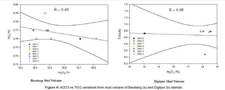
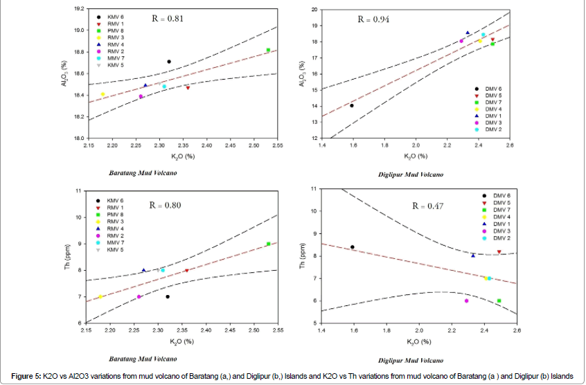
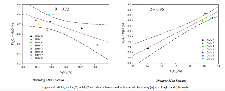
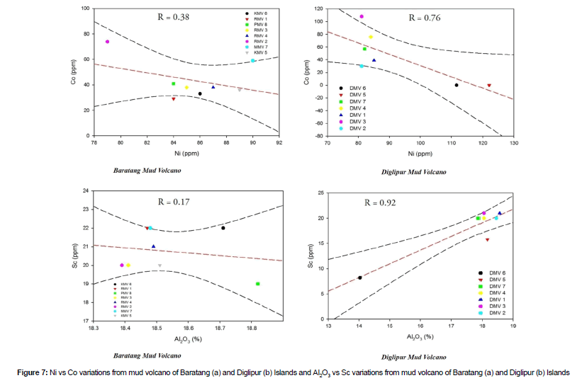
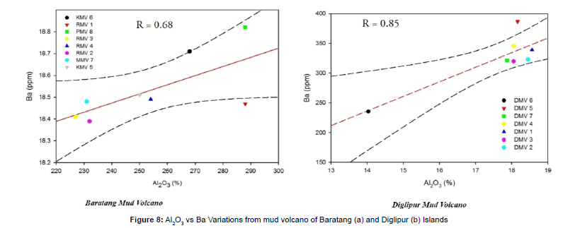
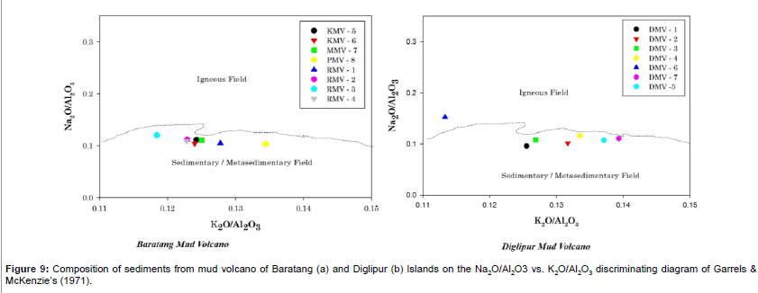
TiO2 concentrations increase with Al2O3 [r = 0.40 in Baratang Mud Volcano and r = 0.08 in Diglipur Mud suggesting that TiO2 is probably associated with phyllosilicates especially with illite Dabard [41] (Figure 4). Al2O3, Th, elements have clear correlation coefficients with K2O [r = 0.81 for Al2O3 and r = 0.80 for Th in Baratang Mud Volcano and r = 0.94 for Al2O3 and r = 0.47 for Th in Diglipur Mud Volcano] suggesting that the absolute abundances of these elements are primarily controlled by Ramasamy [42] (Figure 5). Fe2O3 + MgO are also correlated with Al2O3 [r =0.73 in Baratang Mud Volcano and r = 0.96 in Diglipur Mud Volcano]. The latter correlation implies that these oxides are associated with phyllosilicates, particularly in matrix chlorites (Figure 6). The ferromagnesian trace elements [Co,Ni andSc] relationship illustrate the chemical coherence and uniformity of the mud volcano sediments. Cobalt and Sc abundances show significant correlation with Ni and Al2O3 [r =0.38 in Baratang Mud Volcano, r=0.76 in Diglipur Mud Volcano and r=0.17 in Baratang Mud Volcano, r = 0.92 in Diglipur Mud Volcano] inferring that Co and Sc are partly controlled by Chlorite and other accessory non-aluminous silicate minerals [43] (Figures 6 and 7). Ba have high correlation with Al2O3 [r = 0.68 in Baratang Mud Volcano sediment and, r = 0.85 in Diglipur Mud Volcano]. These correlation suggest that their distributions are controlled by Kaolinitic and Montmorillonite phyllosilicate phases (Figure 8). The K2O/Al2O3 ratio of sediments can be used as an indicator of the original composition of ancient sediments. The K2O/Al2O3 ratios for clay minerals are different 0.0 to 0.3, 0.3 to 0.9, respectively; Cox et al. [44]. The average K2O/Al2O3 ratio for the mud samples of Baratang Mud volcano vary from 0.12 to 0.13 and Diglipur Mud volcano vary from 0.11 to 0.14. In most of the samples, the K2O/Al2O3 ratios are close to the upper limit of the clay mineral range, which suggest that the illite is the dominant clay mineral in these mud volcanoes (Table 3). The chemical data of the mud samples were plotted on discrimination diagrams like Garrels and McKenzie’s Na2O/Al2O3 vs.K2O/Al2O3 diagram. The samples dominantly plotted in the sedimentary field on the Na2O/Al2O3 vs.K2O/Al2O3 diagram, thereby confirming that the sediments are largely of sedimentary origin (Figure 9).
Provenance of sediments and tectonic setting
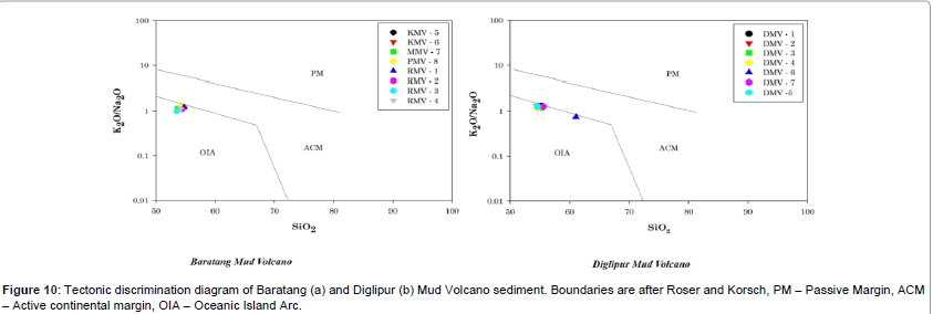
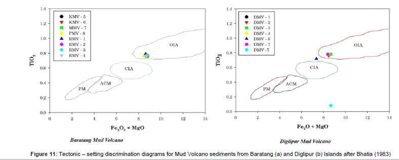
Several classifications have been proposed to discriminate from various origins and tectonic settings and are good indicator of provenance Rosher [13]. Plate-tectonic setting discrimination of ancient sedimentary basins are usually accomplished using major trace element bivariate and multivariate plots. The ratio of SiO2 versus K2O/Na2O provides a tectonic-setting discriminator for sandstonemudstone suites Rosher [13]. As expected from prior knowledge on the tectonic setting of the Mud Volcano formation in Andaman Islands, a SiO2 versus K2O/Al2O3 diagram (Figure 10) clearly shows the Mud Volcanoes sediments of Baratang and Diglipur are in Oceanic Island Arc field defined by Roser and Korsch [13]. Another Discrimination of tectonic settings on the basis of major element data was also proposed by Bhatia [12]; most of the sediments fall in the general area of Oceanic Island Arc of the TiO2 versus Fe2O3 + MgO plot (Figure 11)
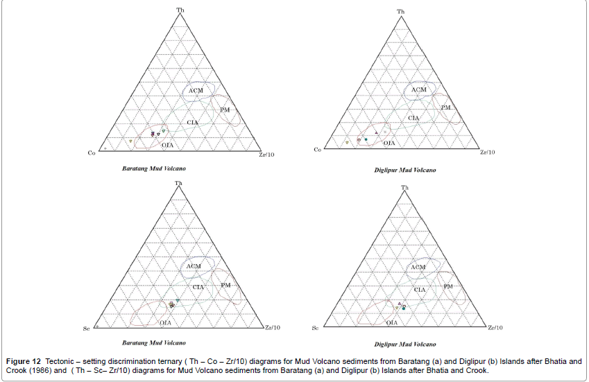
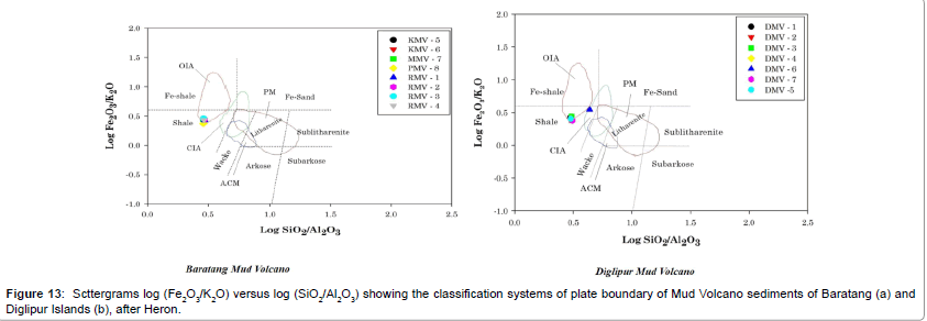
Two ternary plots, in which the highly incompatible elements Th and Zr are plotted against the highly compatible elements Co and Sc, have been used by Bhatia [12], (Figure 12). The analysed samples plot in the fields for oceanic island arc and continental island arc, with generally high Zr/Th ratios and moderate abundances of Co and Sc. The compositional range is correlated with four plate boundary settings: 1] oceanic island arc [= modern fore arc], 2] continental island arc [= modern back arc], active continental margin [= modern leading edge], 4] passive margin [= modern trailing edge], when the compositional fields of Herron [45]. The scattergram log [Fe2O3/K2O] versus log [SiO2/Al2O3 ] discriminates tectonic environments, particularly oceanic island arc, which is located in field labeled “Shale” (Figure 13).
Conclusions
Study of subduction zone is very active field of research because it is known as our planet’s largest recycling system. The subducting slab deliver raw materials such as oceanic lithosphere along with oceanic sediments and Sea water to the subduction factory, where these raw materials reequilibrate with ambient mantle, triggering melting and incidentally crating continental crust on the overriding plate. A special type of geological feature which occur in these zone known as ‘Mud Volcanoes’ bring materials from subducting slab can throw some light on the chemistry of subducting slab. In this context the present study is an attempt to understand the geochemical properties of mud volcanoes in the study area of Baratang and Diglipur in Andaman Islands. From the geochemical analysis it is clearly seen that the minerals like Smectite-illite-kaolinite-chlorite-quartz-calcite assemblage derived from the oceanic crust and originates from a deep environmental conditions. The presence of Smectite and illite indicate that these sediments were derived from the depth zone of 2 to 6 km within the Andaman forearc. Based on all the evidences we conclude that the sampled mud volcano originated at the plateboundary décollement zone, and the sediments and altered oceanic crust of the subducting Indian plate. The clay minerals present in the mud volcano samples from Baratang and Diglipur shows that Smectite group of clay minerals [Montomorillonite] are dominant in the mud sediments and serpentine with lesser amounts of chlorite clay mineral are present. Quartz with minor amount of calcite, feldspar, pyrite, dolomite [carbonatites and ultramafic], Aerinite [formed at relatively low temperature in fractures cutting mafic rocks], Pyrargyrite [lowtemperature mineral; also formed by secondary processes] and illite are also observed in these clay minerals. In the accretionary complexes in Andaman forarc zones, the clay dehydration at depth generate over pressure and alteration of hydrated clays [such as illite, chlorite or other interlayered clay minerals] takes place at the depth of 2 to 6 km. The montmorillonite mineral is having 2:1 interlayer which can host the methane hydrate. Apart from this mineral other clay minerals such as smectite, illite, chlorite or kaolinite are also identified in the mud sediments can be called as a Silicaclatharates. These types of minerals of having framework with cages like voids. These voids are occupied by traces of low temperature hydrothermal thermogenic natural gas hydrates. From the geochemical studies, evaluation of these methane bearing clays at depths are identified. From the study it is seen that the Mud volcano eruptions are driven by the release of high pressurised methane gas from the dissociation of gas hydrates deposits at depth. Mud source beds typically occur at depths of 1-3 km [3,11]. Gas emissions from onshore mud volcanoes are composed primarily of methane [70-99%] and CO2 [46,47]. Submarine mud volcanoes emit methane and CO2 along with other hydrocarbons, sulphur, and noble gases.
| BARATANG | DIGLIPUR | ||
|---|---|---|---|
| Samples | K2O/Al2O3 | Samples | K2O/Al2O3 |
| KMV6 | 0.12 | DMV6 | 0.11 |
| RMV1 | 0.13 | DMV5 | 0.14 |
| PMV8 | 0.13 | DMV7 | 0.14 |
| RMV3 | 0.12 | DMV4 | 0.13 |
| RMV4 | 0.12 | DMV1 | 0.13 |
| RMV2 | 0.12 | DMV3 | 0.13 |
| MMV7 | 0.13 | DMV2 | 0.13 |
Table 3: The ratios of K2O/Al2O3 of Batatang and Diglipur Mud Volcano sediments.
Acknowledgment
The senior author wishes to thank Ministry of Earth Sciences, Seismology Division, Government of India, New Delhi for the sanctioning of Research project and also acknowledge the facilities and permission accorded by Former Vice chancellor of Pondicherry University Prof. J. A. K. Tareen, and Current Vice chancellor of Pondicherry University Prof Chandra Krishnamurthy, Director, Dean and Registrar for constant encouragement and support.
Figure 12:Tectonic – setting discrimination ternary ( Th – Co – Zr/10) diagrams for Mud Volcano sediments from Baratang (a) and Diglipur (b) Islands after Bhatia and Crook (1986) and ( Th – Sc– Zr/10) diagrams for Mud Volcano sediments from Baratang (a) and Diglipur (b) Islands after Bhatia and Crook.
References
- Milkov AV (2000) Worldwide distribution of submarine mud volcanoes and associated gas hydrates Marine Geology 167: 29-42.
- Dimitrov LI (2002) Mud volcanoes the most important pathway for degassing deeply buried sediments Earth Science Reviews 59: 49-76.
- Kopf AJ (2002) Significance of mud volcanism Reviews of Geophysics 40: 1005
- Kopf AJ, Behrmann JH (2000) Extrusion dynamics of mud volcanoes on the Mediterranean Ridge accretionary complex in Salt, Shale, and Igneous DiapirsGeolSoc Spec Publ 174: 169-204.
- Judd AG, Hovland M (2007) Seabed fluid flow; the impact on geology, biology, and the marine environment, Cambridge University Press 475.
- Collier JS, White RS (1990) Diapirism within Indus fan sediments: Murray Ridge, Gulf of Oman, Geophysical Journal International 101: 34-55.
- FernandezP, Vazquez M, Somoza L, Diaz V, Medialdea T, et al. (2007) Gas-related morphologies and diapirism in the Gulf of Cadiz, Geo Mar Lett 27: 213-221.
- Somoza L (2003) Seabed morphology and hydrocarbon seepage in the Gulf of Cadiz mud volcano area: Acoustic imagery, multibeam and ultrahigh-resolution seismic data, Mar Geol 195: 153-176.
- Rensbergen PD, Depreiter B, Panneman J, Henriet P(2005) Seafloor expression of sediment extrusion and intrusion at the El Arraiche mud volcano field, Gulf of Cadiz, J Geophys Res 110.
- Brown KM (1990) The nature and hydrogeological significance of mud diapirs and diatremes for accretionary systems Journal of Geophysical Research 95: 896-982.
- Davies RJ, Stewart SA (2004) Emplacement of giant mud volcanoes in South Caspian Basin: 3-D seismic reflection imaging of their root zones, J GeolSoc 162: 14.
- Bhatia M R (1983) Plate tectonics and geochemical composition of sandstones Journal Geology 91: 611-627.
- RoserBP,KorschRJ(1986)Determination of tectonicsettingofsandstone mudstonesuitesusingSi02 contentandK20/Na20ratio Journal ofGeology94:635-650.
- Armstrong A, Verma J (2005) Critical evaluation of six tectonic setting discrimination diagrams using geochemical data of Neogene sediments from known tectonic settings: Sedimentary Geology 177: 115-129.
- Lennan M, Taylor SM, Eriksson SR(1983) Geochemistry of Archaeanshales from the Pilbara Supergroup, Western Australia: GeochimicaCosmochimicaActa 47: 1211-1222.
- Nesbitt RW, Young GM (1982) Early Proterozoic climates and plate motions inferred from major element chemistry of lutitesNature 299: 715-717.
- Curray JR, Emmel FJ, Moore DG, Raitt RW (1982) Structure, tectonics and geological history of the northeastern Indian Ocean The Ocean Basins and Margins The Indian Ocean Plenum Press New York 399-450.
- Dasgupta S, Mukhopadhayay M (1993) Seismicity and plate deformation below the Andaman arc, northeastern Indian Ocean, Tectonophysics225: 539-542.
- Sengupta S, Ray KK, Acharyya SK, Smeth JB (1990) Nature of ophiolite occurrences along the eastern margin of the Indian plate and their tectonic significance Journal of Geology 8: 439-442.
- Acharyya SK, Ray K, Sengupta S (1990) Tectonics of the ophiolite belt from Naga Hills and Andaman Islands, India Proc Indian Academy Science 99: 187-199.
- Hamilton W (1979) Tectonics of the Indonesian Region U S Geological Survey Professional Paper: 345.
- Mccourt WJ, Crow MJ, Cobbing EJ, Amin TC (1996) Mesozoic and Cenozoic plutonic evolution of SE Asia: evidence from Sumatra, Indonesia in Tectonic evolution of SE Asia Geological Society of London, Spec Pub 106: 321-335.
- Oldham RD (1885) Notes on the geology of the Andaman island in the neighborhoods of Port Blair Rec Geological Survey India 18: 133-145.
- Allen R, Carter A, Najman Y, Bandopadhyay PC, Chapman HJ, et al. (2007) New constraints on the sedimentation and uplift history of the Andaman-Nicobar accretionary prism, South Andaman Island In: Draut. Formation and applications of the sedimentary record in arc collision zones Geological Society America Special Paper 436: 223-254.
- Pal T, Bhattacharya A (2010) Greenschist-facies sub-ophiolitic metamorphic rocks of Andaman Islands, BurmaJavasubduction complex Jour Asi Ear Sci 39: 804-814.
- SrinivasaD,Jafri SH, Flecher IR, Mcnaughton NJ (2010) Constraints on the Tectonic Setting of the Andaman Ophiolites, Bay of Bengal, India, from SHRIMP U-Pb Zircon Geochronology of Plagiogranite Journal of Geology118: 691-697.
- Pal T (2011) Petrology and geochemistry of the Andaman ophiolite: melt rock interaction in a suprasubduction-zone setting, Journal of the Geological Society of London168: 1031-1045.
- Karunakaran C, Ray KK, Saha S (1968) Tertiary sedimentation in the Andaman Nicobar geosyncline Jour Geo Soc India 9: 32-39.
- Ray KK (1982) A review of the geology of Andaman-Nicobar islands Geological Survey India, Misc Pub 41: 110-125.
- Pal T, Chakraborty PP, Duttagupta T, Singh CD (2003) Geodynamic evolution of an outer arc in convergent margin of active BurmaJava subduction complex, a document from Andaman islands, Bay of Bengal Geological Magazine 140: 289-307.
- Roy TK (1983) Geology and hydrocarbon prospects of Andaman Nicobar basin: In: Petroliferousm Basins of India Petroleum Asia Jour KDM, IPE, ONGC, Dehra Dun, India 37-50.
- Singh OP, Subramanya SM, Sharma V (2000) Early Neogene multiple microfossil biostratigraphy, John Lawrence Island: Andaman Sea: Micropaleontology 46: 343-352.
- Pal T, Duttagupta T, Chakraborty PP, Dasgupta SC (2005) Pyroclastic deposits of Mio-Pliocene age in the ArakanYoma Andaman Java subduction complex, Andaman Islands, Bay of Bengal, India Geochemical Journal 39: 69-82.
- Geological Survey of India (2005) Mud volcano Eruption at Bara tang, Middle Andaman, Kolkata, India.
- Badve R, Ghare MA, Rajshekhar C (1984) On the age of the ejected material from the mud volcano of Baratang Island Andaman, Current Science 53: 814-816.
- Ling HY, Sharma V, Singh S, Mazumdar D, Mahapatra AK, et al. (1995) Cretaceous and middle Eocene radiolaria from ejected sediments of mud volcanos of Baratang Island in Andaman Sea of the northeastern Indian Ocean, Journal Geological Society of India 45: 463-469.
- Curray JR (2005) Tectonics and history of the Andaman Sea region Journal Asian Earth Science 25: 187-232.
- Achyuthan H, Eastoe C (1999) Mineralogy and isotopic composition of pyrites-bearing ejects from a mud volcano, Baratang, Andaman Islands, J GeolSoc India 53: 329-334.
- Fertl WH (1976) Abnormal Formation Pressures: Implications to Exploration Drilling and Production of Oil and Gas, DevPetrolSci 382.
- Ware P, Ichram L (1997) The role of mud volcanoes in Petroleum systems: Examples form Timor the South Capsian and Caribbean, Indonesian Petroleum Association, Proceedings of the Petroleum Systems of SE Asia and Australasia Conference.
- Dabard MP (1990) Lower Brioverian formations of the Armorican Massif (France): Geodynamic evolution of source areas revealed by sandstone petrography and geochemistry Sedimentary Geology69: 45-58.
- Ramasamy N (2007) Geochemistry of Neoproterozoicshales of the Rabanpalli Formation, Bhima Basin, Northern Karnataka, southern India: implications for Provenance and paleoredox conditions,Revista Mexicana de CienciasGeológicas 24: 150-160.
- Julleh M (2007) Geochemistry of sandstones from the Miocene Surma Group, Bengal Basin, Bangladesh: Implications for Provenance, tectonic setting and weathering, Geochemical Journal 41: 415-428.
- Cox R, Lowe DR, Cullers RL (1995) The influence of sediment recycling and basement composition on evolution of mudrock chemistry in the southwestern United States: Geochimica et CosmochimicaActa, 59: 2919-2940.
- Herron MM (1988)Geochemical classification of terrigeneous sands and shales from core or log data Journal Sedimentary Petrology 58: 820-829.
- Pedersen RB, Searle MP, Carter A, Bandopadhyay PC (2010)UPb zircon age of the Andaman ophiolite: implications for the beginning of subduction beneath the AndamanSumatra arc, Journal of the Geological Society London167: 1105-1112.
- Chaudhuri, Debasis G, RakeshK, Prasanta S, Bikash S (2011) Geochemical approach to earthquake reconnaissance at the Baratang mud volcano, Andaman and Nicobar Islands. Journal of Asian Earth Sciences 46: 52-60.
Relevant Topics
Recommended Journals
- Oil & Gas Research Journal
- Renewable Energy and Applications Journal
- Oceanography Journal
- Industrial Pollution Control Journal
- Coastal Zone Management Journal
- Climatology & Weather Forecasting Journal
- Geoinformatics & Geostatistics Journal
- Engineering and Technology Journal
- Petroleum & Environmental Biotechnology Journal
- Polymer Sciences Journal
Article Tools
Article Usage
- Total views: 12485
- [From(publication date):
August-2016 - Nov 22, 2024] - Breakdown by view type
- HTML page views : 11479
- PDF downloads : 1006

