Research Article Open Access
Dehistoricisation the Urban Landscape through Transition of the Enclosure Ratio in Urban Fabric of Gonabad City in Iran
Nadi R, Soite W and Tafahomi R*Department of Architecture, School of Architecture and Built Environment, College of Science and Technology, University of Rwanda, Rwanda
- *Corresponding Asuthor:
- Tafahomi R
Department of Architecture, School ofArchitecture and Built Environment
College of Science and Technology
University of Rwanda, Rwanda
Tel: 250786975280
E-mail: tafahomi@gmail.com
Received date: March 24, 2016; Accepted date: April 06, 2016; Published date: April 12, 2016
Citation: Nadi R, Soite W, Tafahomi R (2016) Dehistoricisation the Urban Landscape through Transition of the Enclosure Ratio in Urban Fabric of Gonabad City in Iran. J Archit Eng Tech 5: 162. doi:10.4172/2168-9717.1000162
Copyright: © 2016 Nadi R, et al. This is an open-access article distributed under the terms of the Creative Commons Attribution License, which permits unrestricted use, distribution, and reproduction in any medium, provided the original author and source are credited.
Visit for more related articles at Journal of Architectural Engineering Technology
Abstract
The aim of this paper is to address transitional factors in urban spatial enclosure, proportion, and ratio in the urban fabric as characteristic attribute of historical area. Gonabad city includes historical areas however redevelopment process transited and effected urban landscape. Considering to the urban form and landscape verify the physical aspects mainly enclosure form have changed the landscape and form regarding destroying, redeveloping, and planting trees, however, other factor can be challenged in this process particularly cultural lifestyle. Methodology of the research designed on the qualitative method and graphical analysis technique. Therefore, data was collected by survey techniques in three areas including historical, transitional, and new development. Findings identified that enclosure ratio in the historical part was between 6a-a, that demonstrated the complete enclosure forms in the area but in the transitional between 2a-1/2a as half enclosure and new development areas between 1/8a to 1/2a as less enclosure. Findings identified diversity in the urban landscape form regarding enclosure indicator in two categories including Mass-Space proportion and complementing compounds. As conclusion could contribute that, there is dehistoricisation process in historical especially in transitional part that changes the urban landscape although some historical and traditional landscape elements still exist. The city is lost its specification however; traditional components and compounds could conserve and utilise for historicisation places and locations.
Keywords
Urban landscape; Enclosure ratio; Dehistoricisation; Proportion; Transition
Introduction
The concept of enclosure takes place in spatial, perceptual, and in socio-economic aspects. However, in architectural profession, studies about enclosure mentioned in terms of the tangible ratio between the physical parameters [1] that it has been named as spatial enclosing [2,3]. It seems, in this case, architectural productions have emphasised on physical specifications in surveys, documentation, and interpretations [4] that also can be seen this characteristic as spatial proportion in terms of one of the meaningful and impressive concept [5] in urban design [4], urban landscape, built environment and manmade productions based on diversity in styles, ratios, and attitudes in fabric form [6].
Development background of cities implies on diversities in the historical fabric, form, size, and scale, landscape [7], and townscape, [8] functions [9] and activities [10]. For example, broad historical areas of [10,11] Asia and Europe continents [9] include diverse forms, specifications, policies, and implementations [12]. However, this historical form and landscape of cities changed with negatively effects since 1800 based on industrialisation, standardisation, and modernisation [13]. Hence, documents mentioned the historical landscape forms as heritage values and resources those going to becoming irreversibly lost [14]. In this case, results of studies emphasised that for any rehabilitation and renovation in the spatial structures need to three major activities including re-functionalising of buildings, recreating public spaces and reorienting events [15].
Llopis et al. [16] that specifications of forms and materials have influenced on the cultural values. Other studies also mentioned that the spatial enclosure in both sense and form have been one of the important characters of urbanisation in historical cities [5,17]. The form includes indigenous and historical traces and it can be recognised in both geometric and non-geometric forms in cities although the geometric forms were inspired earlier by engineering, new development, and industrialisation of urbanization. Nevertheless, recognition of the forms of enclosure proportions and ratios are key factor in identification of a specific character of place and location with diverse identity [10].
Gonabad city includes rich historical architecture, archaeology and landscape based on chronological documents [18,19]. This background refers to Parthian and Sassanid dynasties (248 B.C to 650 A.D) in the northeast of Iran on the basis of mythology, however, the old traces of urban fabric has been destroyed by earthquakes, but traditional styles of built environment converted and continued generation by generation into current time. However, those historical traces in city only belong to new era, around 1100 A.D with the same structure. Therefore, some buildings have been survived to reveal and exhibit urban landscape specifications.
Issue
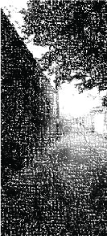
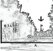
Redevelopment process challenges historical cities and so this has created problems in urban form, landscape and spatial structure in Iran [11] and sometime in either fell into neglect or suffered those harmful redevelopments [20] in historical areas. Studies mentioned that configuration of historical part of city includes cultural value for people however [16]; process of redevelopment has destroyed the concept of form and character of historical parts. This cultural value includes both tangible components such as bazaar, buildings, streets, and intangible such as lifestyle and believing of lay people [21]. However, it seems cities with less historical background, particularly in physical and textural parts did not normally face with this challenge [22] in other side, historical cities with strong landscape faces with challenges [10,11] (Figure 1).

Figure 1: Gonabad city development process.
However, studies showed that fabric of cities modifies like an existence phenomena in whole history [23], this process differs regarding varieties factors and elements [24] in material, fabric, massspace [7], functionality [9]. Indeed, forms of cities have followed multifactor such as geomorphology, climate, and environmental forms, additionally this has been affected by cultural and ideological domains [25,26]. Therefore, wide range of transition could recognise in historical cities and only some of them have reached to balance between historical and modern construction in historical and downtown [27].
As detail, character of urban form is materialised in interaction and interrelation of those spatial envelopment compounds particularly buildings and roads to reflect mass-space interrelations in physical dimensions [1,5,6]. This physical form creates sense of places to recognise character of places and perception of people [3,28]. Hence, spatial enclosure is formed by the proportion between mass and space, which in physical form of cities this combines with paths and buildings [29] to form visual and perceptual enclosure. Additionally, some complement elements could combine with urban fabric to intensify this historical character in places such as trees, Arches, and overshadowing [6,30,31]. However, disappearing the historical elements and forms just in the historical areas reduces vitality in whole city [32].
Nevertheless, the spatial enclosure as character of place has changed by new movement of mass productions in country regarding high speed of increasing population, new development, particularly redevelopment. This attribute makes fast transforming process in the historical part of the city, so, original proportion and ratio convert and so, the natural completing elements eliminate especially trees and arches [11]. However, study showed that the style of landscape has been one of the most influential historical forms to demonstrate fashions [6]. Therefore, significance of this study is to document, compare, and analyse effective factors to form the spatial enclosure proportions in historical places regarding mass-space and natural elements. This problematic issue somehow also was identified by Ng [33] as current challenges in three streetscape attributes: permeability (i.e. spacing between buildings), aspect ratio (i.e. ratio of street width to building height), and tree planting.
Subsequently, it seems urban forms and landscape in historical parts change to utilize dehistoricisation process. However, this is not just changing the form rather it influences on the perception of people as sense of place in daily life [28,34]. For another example, in studies of Airas, explained that demolishing a physical element in the landscape of city influenced on the entire perception of people about the city [35].
Theoretical framework
The concept of enclosure points to proportion, ratio, and scale of the mass and space in a given places. This is also direct related to the ratio of the built-up area superficially height of buildings and open areas [36]. At the same time, this term also points into historical part of cities with particular specifications to the forms, materials, and proportions thus create sense of place based on historical values. As example, studied identified that through the architectural configuration, it could possible to visualise the historical and vital logic that underlies the city, the heritage of people, and cultures that composes it [16]. However, in other studies mentioned this is also possible to have the tradition and modern architectural configuration presenting the same quality in one location. Therefore, architectural configuration and specification create character of city particularly historical areas based on the spatial proportions [27].
Furthermore, studies addressed that the enclosure can be identified to address two objectives, first, to exhibit character and easy recognition either explicitly or implicitly by people as legible places, and second, extension of the functional and activities in the body of street particularly in paths, so surrounding buildings form the sense of enclosure that they normally define as facade of the street [29]. In addition, the spatial enclosure as environment performance indicators to address the feeling and performance of elements in diverse enclosure ratio [3]. In this case, spatial enclosure concept could be combined by different attachable components and compounds in the paths [31] such as trees and greenery not only as green space [33] but also as ecosystem services and specific aesthetic and form in heritage site [6], Arches (Sabat), overshadows, end of viewpoints, and visual corridor [17]. This attachable compound could create varieties in landscape of cities, which, each of these components has dissimilar influences on the sense and perception of general public [37].
However, regenerations of inhabitants challenges urban fabric particularly without clear redevelopment strategies in historical areas and heritage sites [15] and it results to destruction and decay of those characteristic elements and relations and so, in most cases redevelopment could be harmful due to absence of socio-cultural asserts [20]. It seems, historical cities need systematic archive of specification of characteristic and specific components and compounds in the local and national then international levels (Kelly, 2010). At this case, common activities to identify historical specifications focused on graphical techniques like photography, sketching, and drawing to study, analysis, and design solution. For example, studies of Georgoula addressed to variety of 3D and graphical representative techniques to demonstrate historical coastline of the city [38].
Methodology
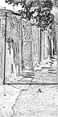
Methodology of this paper designed on the qualitative methods [39] particularly graphical analysis techniques [40,41]. This technique mentioned as phenomenological view into phenomena with cross-sectional approach using photographs, sketches, and physical inventory [42] to consider spatial proportion and ratio between of open space and buildings [36] as envelopment volume of streets and attachable compounds [2]. Additionally, this technique can be applied in measuring spatial proportion and city performance including average height of features and average distance between features [43]. To design the research, all data of open spaces particularly paths and envelopment of buildings were collected by in that, and out that techniques of photography. The techniques was adapted with the human observational angles of view in serial vision in three specific parts of the city in selected spaces, streets, and built-ups [17,29,31,44] to form a basic platform for analytical stages.
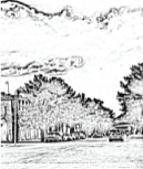
Subsequently, all photos were converted to sketch format to reduce the probability of human error factors in normal perception process especially with regard to the colour and contrast [45]. The sketches were analysed and evaluated in the spatial and textural proportions in Photoshop graphical software. For this stage, the city was categorised in three areas regarding the spatial characteristics to classify the urban landscape form specifications into selective heterogeneous areas including historical, transitional, and new development (Figure 2). Overlay technique selected to recognize the developmental processes and directions of the expansion by analysing aerial photos of the city in different times [46]. Therefore, analysing those aerial photos identified optimum boundaries and buffer in development process. Hence, in this process, result was an adapted platform to compare enclosure form in different areas based on streets and buildings, and those attachable elements. In the similar study, Georgoula et al. applied aerial photos to reconstruct historical city in Greece [38] and in another example used of this techniques for analysing small green spaces in Chicago [31].

Figure 2: Layers of development in the city.
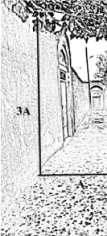
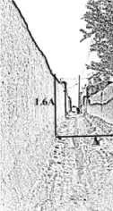
To analyse townscape and urban form, the data was surveyed and then were evaluated in metric lengths and classified regarding massspace proportions. Technique was based on the ratio of length (a) to height (xa) to recognize the ratio and proportion of the enclosure. To evaluate enclosure concepts also was considered those attaching components and compounds that complete enclosure form such as Arches (Sabat), trees, and overshadows.
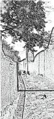
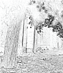
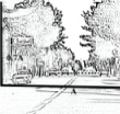
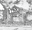
Finally, all photo-data of open spaces including streets, alleys, and setbacks were arranged regarding the locations and characteristics of urban texture in the three specific areas. However, all places especially those indicating limited specifications were not included this study rather the study focused in areas that exhibited obviously and strongly characteristics of places. In this case, they were shot with photography, documented landscape components, and compounds such as canopy character of trees to consider the role with regard to enclosure character and degree of enclosure, as an extension of the Arches (Sabat). The Arches (Sabat) (Arch with overshadowing character) were documented and classified as additional components on the paths with complementally roles to create sense of enclosure (Table 1).
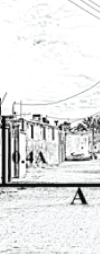
| Areas | Spatial Proportions | Enclosure Sense | Completing Components |
|---|---|---|---|
| Historical | 6a-a (1/1) | Completed Enclosure | Arches (Sabat), Wind Catchments (Badgir),aboriginal Trees,Overshadowing |
| Transitional | 2a-1/2a | Half Enclosure | Supper scale buildings, Arches, New generation of trees |
| New development | 1/8a-1/2a | Less Enclosure | Streets, spatial Envelops, beautifying trees |
Table 1: Summarising of the data analysis based on the Tables 2 and 3.
Data Analysis
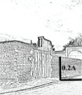
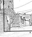
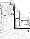
According to the arrangement of Tables 2 and 3, there are dissimilarities in the three given areas. In the historical area ratio of enclosure proportions were rich between 6a-a, so this ratio was emphasised on the complete enclosure proportions. Completing components had significance role to produce this high ratio such as Arches (Sabat), gate entrance, wind catchment, aboriginal trees, and overshadowing. In the transitional area ratio of enclosure proportions were between 2a-1/2a and this identified the half enclosure ratio. Additionally, completing components had role to produce this ratio such as supper scale buildings, statically Arches, new generation of trees. However in the new development area enclosure ratio took place in the low proportion between 1/8a to 1/2a. These results addressed to low enclosure proportion in the new development area. Furthermore, completing components cannot promote the enclosure ration in this area. Table 1 summarised results.
| Area of Data | Spatial proportion of the Mass and space in the Paths | |||||||||
|---|---|---|---|---|---|---|---|---|---|---|
| 1/8A | 1/6A | 1/4A | 1/2A | A | 2A | 3A | 4A | 5A | 6A | |
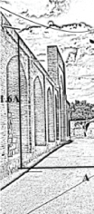
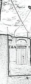
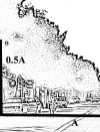
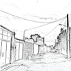
| Historical area | 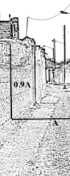 |
 |
 |
 |
 |
 |
||||
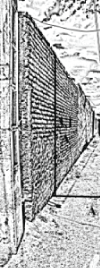
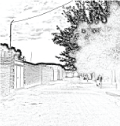
| Transitional area | 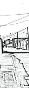 |
 |
 |
 |
 |
 |
||||
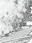
| New Development area | 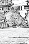 |
 |
 |
 |
||||||
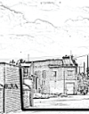
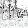
Table 2: Placement of those shot photos in three characteristics parts of Gonabad city.
| Additional components and locations | ARCHES (SABAT) | TREES | Overshadowing | ||||||
|---|---|---|---|---|---|---|---|---|---|
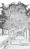
| Historical area | 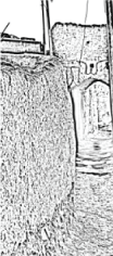 |
 |
 |
 |
 |
 |
 |
 |
 |
| Transitional area |  |
 |
 |
 |
 |
 |
 |
 |
|
| New Development area | 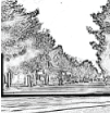 |
 |
 |
 |
 |
||||
Table 3: Additional components in different districts.
Findings
Analysis identifies that the concept of spatial enclosure is formed by two criteria as following: 6-1) mass-space proportions including physical proportion and appropriateness, Frequencies of Proportion, Hierarchy of Ratios, and Lifestyle Patterns, and 6-2) Complementing components such as Arches (Sabat), trees, over shadowing.
Mass-space relation
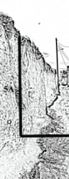
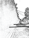
Physical proportion and appropriateness: Landscape of the city depends on the physical components particularly mass-space relation that the interface appears in the interaction between buildings and roads. Minimum spatial proportion should be around (a) as 1/1 proportion to produce enclosure sense in urban fabric although this spatial enclosure reduces from historical part to new development. Even supper scale buildings cannot produce enclosure sense based on losing the human scale. Indeed, buildings can form complementing enclosure proportions in the terms of height around (a=4/1-1/1) scale ratio in the historical part, however, in the transitional parts just some supper-scale buildings have role to form enclosure such as mosques, Bazar, and schools.
Frequencies of proportion: repeating of enclosure creates organic, characterised, and unique form with physical components and compounds in historical parts of the city. This rhythm and harmony of mass-space proportions produce flexible form due to plots, buildings, and alleys that this integration highlights the historical area among other cities in the region. This can be observed that there are complexities and diversity landscape forms based on non-geometric form and complete enclosure ratio, however, in the edges of the historical and in transitional parts can be less recognized this specification in the urban forms.
Hierarchy in the ratio: Enclosure with different homogenous scales and proportions can be produced specific landscape form as substantive character based on the hierarchy and rhythm in enclosure ratio. Indeed, hierarchy and spatial proportion in the landscape, form, and enclosure ratio can be observed in the historical areas which, this creates harmony, unity, consistency in urban landscape.
Lifestyle activities: Enclosure form most adapts form with the lifestyle of laypeople in that specific time and location, so with changing the lifestyles inevitably is changed the form of the city particularly due to vehicles. Therefore, this can be observed diversity of lifestyle from historical to new development parts of the city. For instance, the enclosure in the historical districts are upper than (a=1/1) scale due to the cultural background especially privacy, law rate of vehicles, community, and boundary. While in the transitional and new development parts the enclosure ratio reduces based on redevelopment, standardisation, and modernisation.
Complementing components
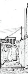
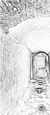
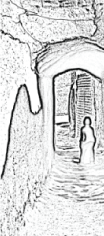
Arches (Sabat): In the case of Arches can be noted this landscape, architectural, and decorative forms are only in the historical parts of the city as valuable source. The forms of those Arches adapt with the urban fabric, indigenous forms, and width of streets and alley for creation of territory, microclimate, and embellishment. In opposite, there are not original forms of Arches in the transitional part and so only can be accounted some structural forms and static elements to make stable the walls of alleys and no in new development part at all.
Trees specifications: trees follow the liner pattern in one side of roads to save the micro-climatically comfortable in the physical frontage of houses to reduce the hot sun light in summer and more light in autumn and winter based on those falling leaf tress species. This is adapted by dissert attributes to create efficient sustainability and microclimate conditions for passer-by particularly with those trees had old age, strong body and leaves, and aesthetical forms. In contrast, in transitional and new parts of the city, trees follow the corridor forms and take place parallel sides of streets and some alleys, and normally planets just as greenery. Nevertheless, specie and typology of trees are changed from traditional fruit and aboriginal such as Mulberry, Zizyphus, Punica Granatum, and Grape to decorative and forest such as Pinus, Platanus, and Ailanthus forms, from historical to transitional and development areas. Therefore, form of landscaping in the historical area changes from vase, round, and few weeping trees forms into oval, pyramid, and columnar. Therefore, this new style of planting changes the enclosure and urban landscape.
Overshadowing: The overshadowing includes an inseparable character and role in the landscape of the city regarding branches of trees and vines in the courtyards. While, this form cannot be observed in transitional and new development areas. In spite of density of trees in these areas such as liner and parallel forms, the overshadowing is not completed and does not point to enclosure form. This planting just is applied in the main streets and alleys as concerning of municipality.
Conclusion
Enclosure is a compositional meaningful character in the historical area with integration of mass-space proportion, Arches, and tress based on hierarchy, proportion, and repeating to create urban landscape form with harmony, unity, continuity sense and perception. However, enclosure forms of the city has been affected by policies of municipality such as expanding of roads, occupying of courtyard, and demolishing of houses under umbrella of the redevelopment policies and going to lose the historical specifications. Despite of issuing some heritage policies in the region, municipality and local government implemented own strategies in the historical parts of the city and it challenged all historical physical elements, so this condition identifies those policies in the country are not effective and efficient.
Landscape of the historical part of the city exhibited an organic, compact, and tight interplay and interrelation between mass and space. Therefore, enclosure form constructed unity and harmony with emphasising on privacy, tradition, and lifestyle of laypeople in the city. Complementing elements have had significance role to form historical landscape such as Arches (Sabat), indigenous trees, and overshadowing. These elements interplay to form urban enclosure landscape based on harmony and variety in proportions, scales, and hierarches. As visual quality, greenery have been specific elements of the historical part based on integrating courtyard of houses with alley and streets to make balance between private and public element to form urban landscape. So, in spite of low density of greenery in the urban fabric, the landscape perceived completely green based on integration, proportion, continuity.
Integrated manmade and natural components have had an undoubted role to form specific landscape and enclosure particularly in historical parts of the city. These elements as contextual components interplayed together to provide sufficient condition to be more legible, characteristic, indigenous, familiar, and introvert. As detail, Arches (Sabat) created unique urban landscape with mixing with trees, and upper branches of trees as overshadowing formed enclosure sense. Arrangement and defragment of those trees with heritage components such as mosque, school, and houses in the city were created particular landscape regarding historically background as a garden city. Integration Manmade and natural elements created specific visual and perceptual character for the area to highlight whole character of city. Therefore, the city has been famous with historical character that nowadays collapses this character and those historical elements and components are disappearing from environment.
Indeed, inhabitants personalise the city based on their needs, expectations, and believe had formed historical landscape and form with applying professional’s part like architects and masons to build urban components and compounds such as buildings, open spaces, streets, and alleys. Hence, the historical forms built regarding human scale to illustrate urban cultural aspects however, redevelopment based on standardisation changed scales, proportions, and balance in the historical areas. Therefore, the landscape and fabric of the historical city cannot be completely saved, therefore, the enclosure form and landscape are transformed based on deconstruction, deformation, and so dehistoricisation.
The local government are less orientated with the tourism planning policies particularly based on the historical places and locations in physical also nonphysical aspects. However, they can exhibit this heritage part with repairing, renovating, and adapting the historical urban landscape aspect for interior visitors as recreational place, and for exterior visitors as educational and attractive location. Despite of wasting historical areas, there are still opportunities to reorient policies on the basis of historical, characteristic, and valuable landscape for conserving reminded areas, expanding area to astounding and developing new urban landscape in adaptation with urban enclosure form as historicisation action plan.
References
- French JS, Urban Space: A BriefHistory of the City Square, Dubuque, IA: Kendall/Hunt Publishing Company, 1983.
- Hedman R, Jaszewski A(1984) Fundamentalsof Urban Design. Planners Press, American Planning Association, New Jersey
- Shi S, Gou Z, Chen LH (2014) How DoesEnclosure Influence Environmental Preferences? A Cognitive Study on Urban PublicOpen Spaces in Hong Kong. Sustainable Cities and Society 13: 148-156.
- Mugerauer R (1997) InterpretingEnvironments: Tradition, Deconstruction, Hermeneutics.University of TexasPress, Texas.
- Curran RJ(1983) Architecture and Urban Experience. Van Nortrand Reinhold Company Ink.
- Kümmerling M, Müller N (2012) TheRelationship between Landscape Design Style and the Conservation Value of Parks:A Case Study of Ahistorical Park in Weimar, Germany. Landscape and UrbanPlanning 107: 111-117.
- Morris A (1994) History of UrbanForm: Before the Industrial Revolutions. (3rdedn ),Longman, New York.
- Benevolo L (1980) The Historyof the City, (1stedn), MIT Press.
- Habermas J(1991) The structural transformationof the public sphere. MIT Press paperback edition,Massachusetts.
- Raymond A (1984) The Great ArabCities in The 16th-18th Centuries: An Introduction. University Press, New York.
- Tafahomi R (2007) Transition Processof Urban Space in Iran.In Postgraduate Seminar, Faculty of Build Environment,University Technology Malaysia, Johor.
- PulawskaS,Starowicz W (2014) EcologicalUrban Logistics in the Historical Centers of Cities.Procedia - Social andBehavioral Sciences 151: 282-294.
- BayulkenB,Huisingh D(2015) Aliterature Review of Historical Trends and Emerging Theoretical Approaches forDeveloping Sustainable Cities.Journal of Cleaner Production 109: 11-24.
- Zhang X, Zhou L, Wu Y, Skitmore M,Deng Z (2015) Resolving the conflicts of sustainable world heritage landscapesin cities: Fully open or limited access for visitors?Habitat International 46:91-100.
- Radoslav R, Branea AM,Gaman MS (2013)Rehabilitation through a holistic revitalization strategy of historical citycentres - Timisoara, Romania. J Cult Herit14: e1-e6.
- Llopis J, Torres A, Serra J, Garcia A(2015) The preservation of the chromatic image of historical cities as acultural value. The old city of Valencia (Spain). J Cult Herit 16: 611-622.
- Cullen G(1961) The Concise Townscape.Architectural Press, New York.
- Ghirshman R (1954) Iran: from theearliest times to the Islamic conquest. Penguin books, Paris.
- Tafahomi R (2010) Documentary of Historical Parts of Gonabad City.Cultural Heritage Organization, Mashhad, Iran, Mashhad.
- SotoudehH, Abdullah WMZ (2013) Evaluationof fitness of design in urban historical context: From the perspectives ofresidents. Frontiers of Architectural Research 2: 85-93.
- Durhan S, Ozguven Y (2013) Breakingthe duality: The Historical Peninsula of Istanbul as an open-air museum.Journal of Cultural Heritage 14: 183-188.
- Hoag JD(1975) Islamic Architecture.Architecture Press, New York.
- Mumford L (1968)The City in History:Its Origins, Its Transformations, and Its Prospects. Mariner Books.
- Weber M (1978) Economy and Society:An Outline of Interpretive Sociology, Guenther Roth and Claus Wittich. Universityof California Press, London.
- Rapoport A (1969) House Form andCulture. (1stedn), Prentice Hall.
- Lang J, Terian SK(1987) CreatingArchitectural Theory: The Role of the Behavioral Sciences in EnvironmentalDesign. Van Nostrand Reinhold, New York.
- Arandjelovic B (2015) Graz, UNESCOcity of Design and Historical Heritage. Cities 43: 78-91.
- Relph E(1976) Place and Placelessness.Pion Ink, London.
- Bently A, Alcock P, Murrian S,McGlynn,Smith G (2003) Responsive Environments: a Manual for Designers.(3thedn), Oxford,Architectural Press, UK.
- Moughtin C, Shirley P(2006) UrbanDesign: Green Dimensions. (2ndedn), Oxford: Architectural Press.
- Hadavi S, Kaplan R, Hunter MCR (2015)Environmental affordances: A practical approach for design of nearby outdoorsettings in urban residential areas. Landscape and Urban Planning 134: 19-32.
- Ozdemir M, Tavsan C, Ozgen S, SagsozA, Kars FB (2008) The elements of forming traditional Turkish cities:Examination of houses and streets in historical city of Erzurum. Building andEnvironment 43: 963-982.
- Ng WY, Chau CK, Powell G, Leung TM(2015) Preferences for street configuration and street tree planting in urbanHong Kong. Urban Forestry & Urban Greening 14: 30-38.
- GehlJ (2011) Life between Buildingsusing Public space. Van Nostrand Reinhold Company, New York.
- Airas A, HallPV, Stern P (2015) Assertinghistorical “distinctiveness” in industrial waterfront transformation. Cities 44:86-93.
- Jamei E, Jamei Y, Rajagopalan P, OssenDR, Roushenas S (2015) Effect of built-up ratio on the variation of air temperaturein a heritage city.Sustainable Cities and Society 14: 280-292.
- Altman, Chemers MM(1984) Culture andEnvironment. CUP Archive, California.
- Georgoula O, Stamnas A, Patias P,Georgiadis C, Fragkoulidou V (2013) Historical coastal urban landscapes digitaldocumentation and temporal study with 2D/3D modeling functionality: The case ofThessaloniki, Greece. J Cult Herite14: 396-402.
- Neuman W (2006) Social Research Methods: Qualitative andQuantitative Approaches.(5thedn), Pearson Education, Ink, Edinbourg.
- Dandekar HC (1988) Qualitative Method, in Urban Planning.In: CataneseAJ,SnyderJC (2ndedn), McGraw-Hill, New York.
- Laseau P(2000) Graphic Thinking forArchitects and Designers. (3thedn), Wiley, New York.
- Groat, Wang D(2002) ArchitecturalResearch Methods. John Willy and Sons Publisher, New York.
- Stamps AE III (2001) Evaluatingenclosure in urban sites. Landscape and Urban Planning 57: 25-42.
- Tafahomi R (2009) Application the Visual and Graphical Techniques ofUrban Design in Urban Vision Documen. Journal of SharNegar (City Writer) 52:25-35.
- Tafahomi R (2014) Mill as manmade Landmark. Lambert AcademicPublishing, Homburg.
- Tafahomi R (2014) Constituting ofUrban Design Framework through Urban Design Deficiencies. Lambert AcademicPublisher, Hamburg.
Relevant Topics
- Architect
- Architectural Drawing
- Architectural Engineering
- Building design
- Building Information Modeling (BIM)
- Concrete
- Construction
- Construction Engineering
- Construction Estimating Software
- Engineering Drawing
- Fabric Formwork
- Interior Design
- Interior Designing
- Landscape Architecture
- Smart Buildings
- Sociology of Architecture
- Structural Analysis
- Sustainable Design
- Urban Design
- Urban Planner
Recommended Journals
Article Tools
Article Usage
- Total views: 11392
- [From(publication date):
June-2016 - Apr 05, 2025] - Breakdown by view type
- HTML page views : 10441
- PDF downloads : 951