Control Over River Bank Erosion: A Case Study of Ganetti Station, Northern States, Sudan
Received: 07-Jul-2015 / Accepted Date: 29-Jul-2015 / Published Date: 08-Aug-2015 DOI: 10.4172/2157-7617.1000287
Abstract
The Ganetti station soil erosion model was used to quantify the amount of runoff in the upper catchment that takes into account effect of land cover change and also how different factors affect surface runoff. The study is constructed using the mathematical modeling language which allows for great flexibility and GIS that uses a raster type representation of the catchment which allows for a detailed representation of the processes. The results show not only the total runoff at the outlet but also the amount of sediment. The overall objectives of this work is to demonstrate bank erosion control using image processing and hydrological model for River bank erosion based on the time series, assess soil erosion in sub-watershed, use Sediment Transport Index (STI) to replace the slope gradient in the revised MMF model and assess erosion prone areas in inaccessible land areas. The Bank Stability and Toe Erosion Model is a physically-based model. It represents the failure by shearing of a soil block of variable geometry and the erosion by flow of bank and bank toe material. The effect of toe erosion, vegetative treatments or other bank and bank toe protection measures can be illustrated by calculating the actual Factor of Safety (Fs) of the bank.
Keywords: Factor of safety and beaching; Ganetti station; River bank erosion
11590Introduction
River bank erosion is the single most common problem at river which flows on alluvial plain although the plain usually exists at lowland area. The erosion causes a lot of damage. That can be seen from existence of meandering symptom at the river. The erosion will result in the loss of land, or property, thus endangering people who live near the river.
Factors responsible for erosion are climate, topography, soil, Landover, landuse and management practices. Preventing or controlling soil erosion relies on selecting appropriate strategies for soil conservation, which requires a thorough understanding of the process of erosion. Many strategies for erosion control have been applied such as crop and vegetation management and soil management. However the plant cover and the presence or absences of conservation measures influence very much the rate of erosion.
Land degradation is a process that lowers the capacity of land. According to FAO [1], there are six types of land degradation: water erosion, wind erosion, soil fertility decline, salinization, water logging, and lowering of the water table. The unbalance between land resource regeneration rate and population growth rate leads to lack of suitable land for agriculture. Unless soil conservation and management practices are implemented properly, soil erosion can cause loss of plant nutrient, weak soil aggregation and finally low agriculture production. Improper land use practices in sloping areas accelerate soil erosion.
Soil erosion not only reduces soil depth, but also reduces the capacities of soil such as water holding capacity, and decreased plant nutrient. In the long term, soil productivity will be decreased. Furthermore it can cause offsite effects including pollution in water, downstream sediment in river bank and reservoirs. It is necessary to understand erosion and sedimentation process for soil conservation planning.
In this paper, The Ganetti station soil erosion model was used to quantify the amount of runoff in the upper catchment that takes into account effect of land cover change and also how different factors affect surface runoff. The study is constructed using the mathematical modeling language which allows for great flexibility and GIS that uses a raster type representation of the catchment which allows for a detailed representation of the processes. The results show not only the total runoff at the outlet but also the amount of sediment.
The overall objectives of this work is to demonstrate bank erosion control using image processing and hydrological model for River bank erosion based on the time series, assess soil erosion in sub-watershed, use Sediment Transport Index (STI) to replace the slope gradient in the revised MMF model and assess erosion prone areas in inaccessible land areas.
The area near Ganetti station in Northern state, Sudan, severely affected by erosion, has been selected for the study. The geographical extent of the study area (Figure 1) is 316000-320000 E and 1993600- 1990600 N, lie in second loop of river Nile.
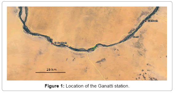
Figure 1: Location of the Ganatti station.
Methodology
According to the process of quantifying the use potential of land [2] on the basis of its biotic and abiotic attributes plays an important role in the rational and sustainable use of natural resources. A fundamental challenge of sustaining the productivity, biodiversity and integrity of ecosystems regionally and globally is to ensure that local decision makers including individual land users, groups, or institutions use the quantification of the biophysical potential of ecosystems obtained by land evaluation. On the other hand the quantifying soil respiration in response to short-term tillage practices and climate change plays a large role in the erosion of the soil [3].
The Bank Stability and Toe Erosion Model is a physically-based model. It represents the failure by shearing of a soil block of variable geometry and the erosion by flow of bank and bank toe material. The effect of toe erosion, vegetative treatments or other bank and bank toe protection measures can be illustrated by calculating the actual Factor of Safety (Fs) of the bank.
The Bank Stability Model combines tow limit equilibrium-method models that calculate Factor of Safety (Fs) for multi-layer stream banks, vertical slices with tension crack [4] and cantilever failures [5-7]. The bank is said to be 'stable' if Fs is greater than 1.3, to provide a safety margin for uncertain or variable data. Banks with an Fs value between 1.0 and 1.3 are said to be 'conditionally stable', i.e. stable but with little safety margin. Slopes with an Fs value less than 1.0 are unstable.
Types of stream bank failure
Stream bank failure can occur by several mechanisms (Figure 2), including cantilever failures of undercut banks, toppling of vertically arranged slabs, rotational slumping, and wedge [5]. The type of failure reflects the degree of undercutting (if any) by fluvial scour or other mechanisms, and the nature of the bank materials. The Bank Stability Model simulates types b) and c). All these are shear-type failures that occur when the driving force (stress) exceeds the resisting force (strength).
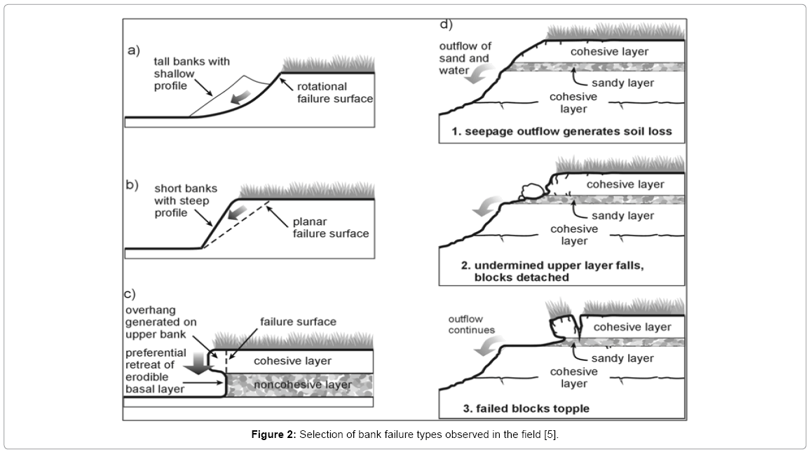
Figure 2: Selection of bank failure types observed in the field [5].
Stream bank stability analysis
Stream bank stability can be analyzed using methods of engineered slopes and embankments. Driving forces for stream bank instability are controlled by bank height and slope, the unit weight of the soil and the mass of water within it, and the surcharge imposed by any objects on the bank top. The ratio of resisting to driving forces is commonly expressed as the Factor of Safety (Fs), where values greater than one indicate stability and those less than one, instability.
Planar failure
The vertical slice method is an adaptation of the method employed in the concepts model [8]; Figure 3 shows an assumed failure block configuration and its subdivisions into slices. If there are n numbers of soil layers comprising the failure block, there will be n number of slices, to increase the accuracy of factor of safety Fs, the n slice further subdivided.
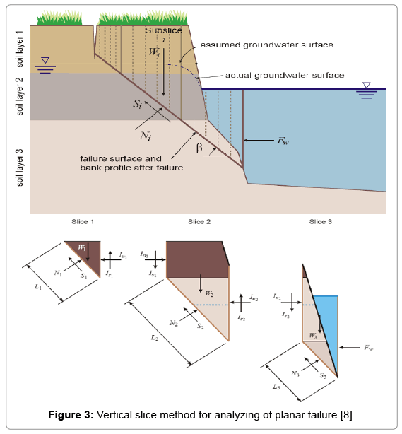
Figure 3: Vertical slice method for analyzing of planar failure [8].
Forces acting on a slice i (Figure 3) are:
Si = shear force mobilized at the base of the slice (kN/m)
Wi = weight of the ith slice per meter length (kN/m)
Ni = interslice normal and shear forces (kN/m)
Fw = hydrostatic-confining force due to external water level (kN/m)
Is = interslice shear force (kN/m)
The Vertical Slice method evaluates normal and shear forces active in segments of the failure block. The confining force due to the water in the channel is modeled by extending the slip surface vertically through the water and applying a horizontal hydrostatic force on the vertical portion of the slip surface.
The shear strength of soil can be described by the Mohr-Coulomb criterion:
τf = c' + σ tan φ'
ci' = effective cohesion (kN/m2)
φ' = effective angle of internal friction (degrees).
τf = shear stress at failure (kN/m2)
σ = normal stress (kN/m2)
The interslice normal and shear forces Ni are neglected and the normal force and given by
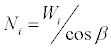
Where:
β = failure-plane angle (degrees from horizontal)
The shear force acting at the base of the failure plane Si is computed by:
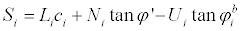
Where:
Ui= hydrostatic-uplift force on the saturated portion of the failure surface (kN/m)  = angle indicating the increase in shear strength for an increase in matric suction (Ui)
  varies between for saturated soils and a value commonly ranging from 15 to 20 degrees for unsaturated soils.
And
Where:
γ =unit weight of water
zi =elevation of base of slice i at its centerline
zg =elevation of ground water table
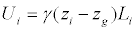
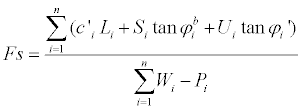
Factor of safety is determined by the balance of forces in horizontal and vertical directions for each sub-slice and in the horizontal direction for the entire failure block (Figure 4). Fs is given by:
Figure 4: Possible failure geometries for 4 numbers of elevations at which the Fs is evaluated.
Cantilever failure
The cantilever shear failure algorithm is a further development of the method employed in the concepts model [8]. But simply, the Fs is the ratio of the shear strength of the soil to the weight of the cantilever.
If the bank is submerged then the weight of the layers affected by the water are reduced to their submerged weight. By this method, the vertical hydrostatic confining force is included in the calculation. The Fs is given by:
Case Study Ganetti Station
Channel and bank geometry
Figure 5 shows Nile river cross section at interested location at Ganetti station where bank erosion stability analysis was conducted for the left side bank, left floodplain extended more than 120 m at elevations ranged between (+245.5 to +244).
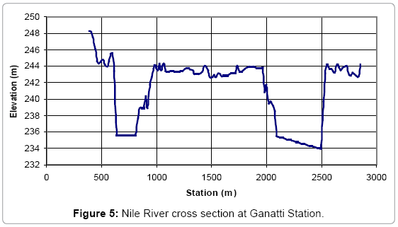
Figure 5: Nile River cross section at Ganatti Station.
Lift bank profile is shown in Figure 6, failure of bank assumed to occur during the low flow period in which water surface elevation is lower than top bank elevation (W.S elev. = +242).
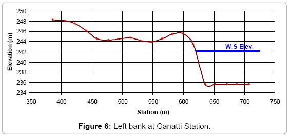
Figure 6: Left bank at Ganatti Station.
Soil characteristics
Bank soil types that distributed within left bank block are represented in Figure 7, it consists of 5 main types of soil layers (silt, silt clay, clay silt and fine sand), and Table 1 gives the main properties for each type.
| Soil type | Unit weight γ (kN/m3) | Cohesion c' (kN/m2) | Angle of frictionΦ' Deg) | |
|---|---|---|---|---|
| 1 | Fine Sand | 18 | 0 | 10 |
| 2 | Clay | 19 | 15 | 30 |
| 3 | Clay Silt | 18.5 | 12 | 26 |
| 4 | Silt Clay | 18.5 | 13 | 26 |
| 5 | Silt | 18 | 14 | 25 |
Table 1: Soil properties.
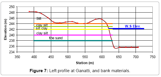
Figure 7: Left profile at Ganatti, and bank materials.
Selection of bank failure mode
Previous description of soil layers for the study area shows that lower layers of bank block materials consist of non-cohesive layer (fine sandy soil) that is a significant indicator for the most likely failure mode that may occur. Basal sand layer could be eroded and retreated under the low flow conditions causing cantilever failure (Figure 8).
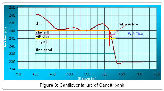
Figure 8: Cantilever failure of Ganetti bank.
Results of stability analysis
The results obtained from the stability analysis are presented in details in Table 2. For Ganetti station the stability analysis has been conducted for two cantilever failure scenarios: (1) retreating of sand basal layer by 2 m (Fs>1.3). And (2) retreating of sand basal layer by 3.5 m. (Fs<<<1.0) (Figure 9).
| Slice n | Soil Type | Area A (m2) | Wi= A*γ (kN/m) | Li (m) | Ni | zg | Zi | Ui | c' | Ø' | tan Ø' | Si | Pi=1/2*γw*g*h (kN/m) | X | Y |
|---|---|---|---|---|---|---|---|---|---|---|---|---|---|---|---|
| 1 | silt | 0 | 0 | 0 | 0 | 0 | 0 | 0 | 15 | 25 | -0.133 | 0 | 0 | 0 | 0 |
| 2 | clay silt | 0 | 0 | 0 | 0 | 0 | 0 | 0 | 12 | 26 | 1.178 | 0 | 0 | 0 | 0 |
| 3 | silt clay | 2 | 37 | 1 | 0 | 0 | 0 | 0 | 13 | 26 | 1.178 | 13 | 0 | 13 | 37 |
| 4 | clay silt | 5 | 92.5 | 2 | 0 | 239.5 | 242.5 | 60 | 12 | 26 | 1.178 | 24 | 50 | 94.72 | 42.5 |
| Fs =X/Y= 1.3550341 | Σ | 107.72 | 79.5 | ||||||||||||
Table 2: Results of stability analysis.
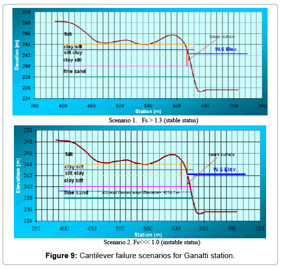
Figure 9: Cantilever failure scenarios for Ganatti station.
River Bank Protection
The function of riverbank protection is to avoid bank erosion, which is caused by current attack. Effect of the erosion is collapsing of riverbank, causing movement of river channel. The movement is vertical and horizontal direction, arise meandering, braiding, or move and changing it river path.
Bank protection that is commonly used is made from masonry or concrete which is expensive and not natural or not environmental friendly; disagrees with spirit and soul of eco-hydraulic.
Some low-cost river bank protection methods have been tried by some developed countries (Figure 10) (adapted from Gordon, McMahon and Finlayson [9]) that are:
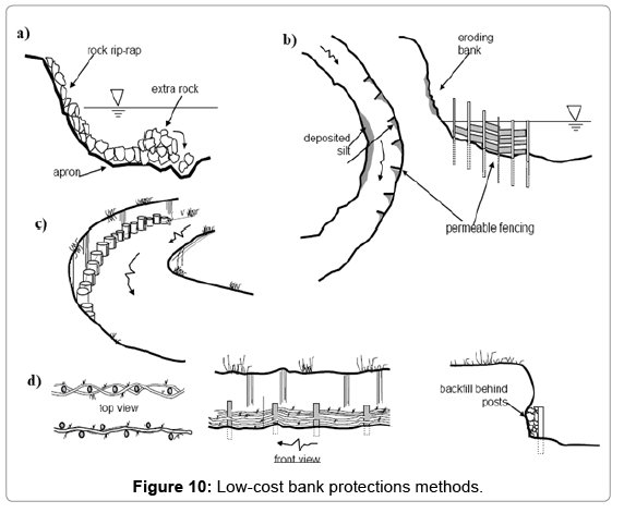
Figure 10: Low-cost bank protections methods.
Stone “rip-rap” or “beaching”
Lining the banks with some stone is feasible if local source of rock is available. The pits in stones and the nooks and crannies between them increase the amount of area for colonization by aquatic insects. Plants can take root between the rocks and rocks ledges can be used as resting and roosting sites by waterfowl. Stone is a relatively permanent option if the stones used are sufficiently large that they do not wash away during high flows.
Steel and woody debris
In areas where tree pruning, snag removal and brush cutting must be carried out these materials can be recycled to the stream in the form of bank protection. Debris can also be used to slow the water, trap silt and sediment and permit the growth of river-edge plants.
Conclusions
• The erosion will result the loss of land, or property and endanger people who are live near the river.
• A bank failure occurs when the driving force (stress) exceeds the resisting force (strength).
• The most likely failure mode that can occurred in Ganetti left bank is cantilever failure during low flow conditions due to retreating of non-cohesive layer (fine sandy soil) that existing in 4m depth as basal layer.
• Bank protection that commonly use is made from masonry or concrete, this type is expensive and not natural or not environmental friendly; disagree with spirit and soul of ecohydraulic.
• The recommended method of protection for Ganetti bank is stone “rip-rap”.
Acknowledgement
We would like to thank the Basin Nile Initiative for financial support.
References
- FAO (1994) The collection and analysis of land degradation data. Report of the expert consultation of the Asian Network of Problem Soils (Bangkok 25-29 October 1993). RAPA publ 3: 261.
- Kiliç S, Senol S, Evrendilek F (2003) Evaluation of land use potential and suitability of ecosystems in Antakya for reforestation, recreation, arable farming and residence. Turk JAgrForest27:15-22.
- Akbolat D, Evrendilek F, Coskan A, Ekinci K(2009) Quantifying soil respiration in response to short-term tillage practices: a case study in southern Turkey. Acta Agr Scandinavica Section B-Soil Plant Sci 59: 50-56.
- Morgenstern NR, Price VE (1967) A numerical method for solving the equations of stability of general slip surfaces. Comput J 9: 388–393.
- Thorne CR, Murphy JB, Little WC (1981) Stream channel stability, Appendix D: Bank stability and bank material properties in the bluffline streams of northwest Mississippi. U.S. Department of Agriculture, Agricultural Research Service, National Sedimentation Laboratory, Oxford, MS.
- Thorne CR, Tovey N Keith (1981) Stability of composite river banks. J Earth Surface Process Landforms. 6: 469-484.
- Pizzuto JE (2008) Streambank erosion and river width adjustment. Segmentation Eng 387-438.
- Langendoen EJ (2000) CONCEPTS-CONservational Channel Evolution and Pollutant Transport System Report, U.S. Department of Agriculture, Agricultural Research Service, National Sedimentation Laboratory, Oxford, MS.
- Gordon ND, McMahon TA, Finlayson BL (1992) Stream Hydrology: An Introduction for Ecologists. Wiley.
Citation: Kheiralla KM, Siddeg AS (2015) Control Over River Bank Erosion: A Case Study of Ganetti Station, Northern States, Sudan. J Earth Sci Clim Change 6: 287. DOI: 10.4172/2157-7617.1000287
Copyright: © 2015 Kheiralla KM, et al. This is an open-access article distributed under the terms of the Creative Commons Attribution License, which permits unrestricted use, distribution, and reproduction in any medium, provided the original author and source are credited.
Share This Article
Recommended Journals
Open Access Journals
Article Tools
Article Usage
- Total views: 18648
- [From(publication date): 8-2015 - Apr 03, 2025]
- Breakdown by view type
- HTML page views: 13821
- PDF downloads: 4827