Climate Characterization and Variability in Agro-Ecological Zones of Anger Sub-Basin, Nile Basin of Ethiopia
Received: 01-Sep-2023 / Manuscript No. EPCC-23-2963 / Editor assigned: 04-Oct-2019 / PreQC No. EPCC-23-2963 (PQ) / Reviewed: 18-Oct-2019 / QC No. EPCC-23-2963 / Revised: 21-Jun-2023 / Manuscript No. EPCC-23-2963 (R) / Published Date: 28-Jul-2023 DOI: 10.4172/2573-458X.1000348 QI No. / EPCC-23-2963
Abstract
The study was carried out to characterize and analyze the variability of the local climate in the agro-ecological zones of the Anger sub-basin for agricultural purpose. The results show that the mean annual rainfall ranges between 1246.8 mm to 2067.9 mm for all agro-ecological zones with the CV of varying from 14.5 to 28.6 in the subbasin. Rainfall concentration index ranges from (14.5% to 15.1%) indicating irregular rainfall distribution and standardized rainfall anomaly shows that dry condition is higher in warm sub-humid lowland and warm moist lowland agro-ecological zones than in tepid sub-humid mid highland zones of the sub-basin. The variability in the average onset date of rainfall in varies from125 ± 7 DOY (May 04 to 128 ± 6 DOY (May 07) with CV varies from 8.4% to 13.5 % in all AEZ. Also, the average cessation dates rainy season varies from 304 ± 1 (27 Oct) to 308 ± 5 (Nov 03) with CV varies from 3.3% to 4.3% in all zones. The rainfall trend is not statistically significant (P>0.05) for all the agroecological zones. An increasing trend also is seen in temperature which is highly related with a dry spell of the subbasin. The degree of dry spell probability descends down to zero from half of April to end of September and curves converge to their minimum only during the peak rain period (June to August or DOY 153-244) in all agro-ecological zones.
Keywords
Anger subbasin; Variability; Instat; Mann-Kendall; Agro-ecological zones
Introduction
Change in rainfall, temperature and in other climate variability indicators may happen in various ways, over different time scales and at different geographical scales. Variability is a very important inherent characteristic of climate and it varies on all time scales. There has been much recent public and scientific interest in climate variability and change, and the possible role of human activity in observed climate change. As more than 85% of Ethiopian farmers depend on agricultural activities, all field operations up to harvesting are rainfall dependent. As a result, inconsistent distribution of rainfall and shorter growing period of crops are expected. So, climate characterization and variability in terms of onset, cessation and length of growing season, dry spell analysis and trend analysis of the local climate are therefore crucial for decision making to increase production and productivity.
Identification of the onset and cessation of the rainy season, as well as the Length of the Growing Season (LGP), is important for crops to keep from water stress by determining dates for supplementary irrigation if necessary to maintain good productivity [1]. For a better understanding of the variability of seasonal rainfall in terms of onset, cessation and LGP separation by agro-ecological zone are necessary. The study area is characterized into three agro-ecological zones; tepid sub-humid mid highlands, warm moist highlands and warm sub-humid lowlands. Studies on earth’s global climate show an increasing trend on average air temperature. An increasing of average temperature related to the distribution of dry spell and in humid areas the success or failure of the crops, particularly under rainy conditions is highly related to the distribution of dry spells [2]. In the principle of the fact that the past gives a clue to the future, probabilistic analysis of the weather records of the past is an important step towards understanding and developing appropriate technologies that support crop growth under varying rainfall regimes.
Since most of the study area is rainfed agriculture based on achieving maximum benefits from cropland variability rainfall, trends of the temperature and distribution of dry spells within a year in all agro-ecological zones are useful [3]. This information’s may be used for deciding a particular crop or variety in a given location and could be used in decision making with respect to supplementary irrigation and field operations in agriculture.
Materials And Methods
Description of the study area
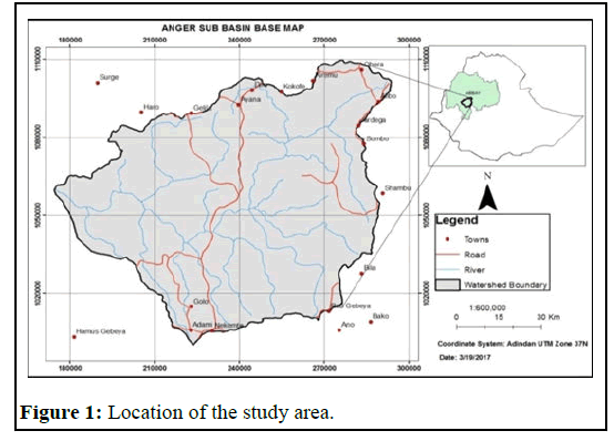
The research was conducted in Anger sub-basin of the upper blue Nile river basin, Ethiopia. Geographically, it is located in between latitudes 9°08’ and 10°05’ North latitudes and 36°01’ and 37°07' (Figure 1). The altitude varies approximately from 868 masl to 3144 masl with unimodal rainfall pattern in the sub-basin.
The mean annual rainfall ranges from 1246 mm at eastern lowlands to 2067 mm in highland areas of the sub-basin. The average annual daily maximum and minimum temperatures in the three main agroecological zones (tepid sub-humid mid highlands, warm moist highlands and Warm sub-humid lowlands) vary from 22.6°C to 31.2°C and 11.57°C-15.52°C respectively over the sub-basin.
Data sources and quality assessment
The daily meteorological data (rainfall, minimum and maximum temperatures) were collected from the National Meteorological Agency (NMA) of Ethiopia for the period from (1986-2014) of the gauged station available in each agro-ecological zone for analysis. Appropriately, the collected data was arranged by the Day of a Year (DOY) entry format and the missed data of temperature and precipitation was done by spatial interpolation and simulated by using INSTAT +v.3.37 first order Markov-chain simulation models respectively. In this study data quality control for selected stations was done using the procedure in RclimDex 1.0 software and homogeneity test was assessed using an R analytical tool, RHtest.
Analytical methods
Rainfall data of daily records for 29 years (1986 to 2014) of four weather stations were used for these analyses [4]. Nekemte and Gida Ayana stations are selected to represent tepid sub-humid mid highlands, Anger station is for warm sub-humid lowlands and Didessa stations for warm moist highlands are used and the selection depends on the location of the station within in the watershed and Didesa for its covering that zone similar within in the Didessa catchment.
Onset, cessation and Length of Growing Season (LGS): For this particular study, the onset, cessation and LGP definition was adapted from Stern et al. By this definition, a day with accumulated rainfall amount of 20 mm in three consecutive days after a specified date (in this case 4th April, for Gida Ayana, 15th April for Nekemte, 1st April for Anger and 10th April for Didessa) and not followed by greater than 9 days of dry spell length within 30 days is defined as the onset date. Whereas, cessation of the rainy season is defined as any day when the soil water reaches zero with the assumption of a fixed average evapotranspiration of 5 mm per day and 80 mm/meter of soil water holding capacity after 30th September was applied [5]. This date is set based on field survey and interview with meteorologists at each station selected for analysis. By using this definition the built-in INSTAT statistical software version 3.37 was used for the analysis and LGP was determined by taking the difference between the end and the onset dates of a rainy or sowing season.
Rainfall variability analysis methods: Rainfall variability analysis of the study were expressed by using standardized anomaly index for annual variability, precipitation concentration index for monthly variability of rainfall, coefficient of variation for seasonal rainfall variation and other descriptive statistics were used.
Standardized Anomaly Index (SAI) was calculated as the difference between the annual total of a particular year and the long term average rainfall records divided by the standard deviation of the long term data [6]. This index is used to examine the nature of the trends and enable to determine the dry and wet years in the record. Its formula is given as:

Where, Z is standardized rainfall anomaly, x is the annual rainfall total of a particular year, μ is mean annual rainfall over a period of observation and δ is the standard deviation of annual rainfall over the period of observation. Standardized anomaly index value was categorized according to McKee classification (Table 1).
| SAI value | Category |
|---|---|
| 2.0+ | Extremely wet |
| 1.5 to 1.99 | Very wet |
| 1.0 to 1.49 | Moderately wet |
| -0.99 to .99 | Near normal |
| -1.0 to -1.49 | Moderately dry |
| -1.5 to -1.99 | Severely dry |
| -2 and less | Extremely dry |
Table 1: SAI value classification.
Monthly rainfall variability was investigated using Precipitation Concentration Index (PCI) series and its coefficient of variability.

Where, Pi is the rainfall amount of the ith month. PCI values of less than 10 indicate uniform monthly distribution of rainfall, PCI values between 11 and 20 shows high concentration and values more than 21 shows a very high concentration in the distribution of rainfall.
In addition PCI, variability of rainfall was expressed by statistical parameters such as mean, standard deviation, maximum, minimum and the Coefficient of Variation (CV). Coefficient of variation was used to classify the degree of variability of rainfall events as less, moderate and high [7]. The CV is used to classify degree of variability of rainfall as less variable, when (CV<20%), moderate, when (CV from 20%-30%) and highly variable for values of (CV>30%). Areas with CV>30% are said to be vulnerable to drought.
Finally, the rainfall characteristics over Anger sub basin were analyzed using box plots and whisker technique. These are best graphical representation when analyzing variability, in fact they differentiate box and whiskers plotting, the box represents the middle 50% of the whole dataset, while whiskers represent the magnitude of the spread of the rest of the dataset about the median or mean.
Trend analysis: Mann-Kendall (MK) test was employed. Mann- Kendall test is one of the most widely used non-parametric tests for detecting a trend in hydro-meteorological time series and preferred for trend analysis when more than one stations are tested in a single study as well as MK was suitable in cases where the data with skewed variables, non-normally distributed, data with outliers and data showing non-linear trend were detected.
Also, this non-parametric test is less sensitive to outliers and test for a trend in a time series without specifying whether the trend is linear or nonlinear [8]. This type of trend analysis tests the null hypothesis of no trend against the alternative hypothesis of positive or negative monotonic trends over time that is present in the dataset being analyzed.
MK test compares the relative magnitude of a data value with all subsequent data values in the ordered time series. The initial value of the MK test statistics S is assumed to be zero implying no trend [9]. If a data value from a later time period is found to be greater than the data value from an earlier time period, then S is incremented by one. On the other hand, if the data value from the later time period is lower than that of the earlier period, the MK test statistics S is reduced by one. The overall result of all increments and decrements provides the final S value which lies between -1 and +1. The Mann-Kendall test statistics is given as follows.

Where S is the Mann-Kendal’s test statistics which is any integer between

and

Xj and Xk are the sequential data values of the time series in the years i and j
(j>i) and N is the length of the time series [10]. A positive S value indicates an increasing trend and a negative value indicates a decreasing trend in the data series.
The sign function is given as:

For n ≥ 10, the statistic S is approximately normally distributed with the mean and variance as follows:

Where q is the number of tied group’s tp is the number of data values in the pth group. In this case the standard test statistics Z is computed as follows:

The presence of a statistically significant trend was evaluated using the Z value. A positive value of Z indicates an upward and negative value of Z indicates downward trend. To test for either an upward or downward monotone trend (a two-tailed test) at α level of significance, H0 is rejected if the |Z|>Z1-α/2, where Z1-α/2 is obtained from the standard normal cumulative distribution tables [11]. Finally, the trends of mean annual historical rainfall and temperature over the period of (1986-2014) were graphically presented for the representative stations.
Dry spells risk analysis using probabilistic method: Dry spells are analyzed to determining distribution of rainfall and the probability of availability of rains during the critical water requirement periods of crop growth in the rains season. For this specific study, dry spell analysis was carried out by daily rainfall is fitted to the simple Markov Chain model to determine the probability of dry spell length exceeding 5, 7, 10 and 15 days for the two rainy seasons (March-September) using INSTAT Statistical software version 3.37.
Results And Discussion
Onset, end and length of growing period
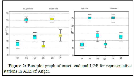
The onset, end and length of the growing period computed based on days of the year of Anger agro-ecological zones are summarized in Table 2 and the Whisker box plot which indicates the existing variability in the rainfall features (Figure 2). The variability in the average onset date of rainfall for tepid sub-humid mid highlands zone is 120 ± 5 DOY (April 29) at Nekemte stations and 125 ± 7 DOY (May 04) at Gida Ayana with CV of 10 and 8.4% respectively. Similarly, for warm sub-humid low land zone represented by Anger station and warm moist lowlands at Didessa are 128 ± 6 DOY (May 07) and 126 ± 5 DOY (04 May) with CV 13.5 % and 11.1% respectively.
The average end dates of rainy season in tepid sub-humid mid highlands at Nekemte and Gida Ayana are 311 ± 5 (Nov 06) and 303 ± 5 (29 Oct) with CV of 4% and 4.1% and in warm sub-humid lowland at Anger and warm moist lowlands at Didessa are 304 ± 4 (30 Oct) and (27 Oct) with CV of 3.3% and 4.3% respectively [12]. The rain starts late in tepid sub-humid mid highland agro-ecological zones and ends more or less between October 29 to November 06 in all agroecological zones of the basin.
The Length of Growing Period (LGP) in tepid sub-humid mid highlands zone of the basin varies from (144-233) DOY days of the year with 29 years mean value of 191 and 178 days at Nekemte and Gida Ayana stations respectively and less variation on the length of growing period is occurred in this zone [13]. Also, in warm sub-humid low land zone length of growing season varies from 143 days to 212 days of the year with mean value of 181 days, CV 10.4% and SD of 19 days.
| Stations | Nekemte | Gida Ayana | Anger | Didesa | |
|---|---|---|---|---|---|
| Onset | Max | 153 | 154 | 153 | 154 |
| Min | 106 | 95 | 95 | 101 | |
| Mean | 120 | 125 | 28 | 126 | |
| CI | 120 ± 5 | 125 ± 7 | 128 ± 6 | 126 ± 5 | |
| SD | 13 | 18 | 16.6 | 14 | |
| CV | 0.1 | 0.84 | 0.135 | 0.111 | |
| 25th perc | 109 | 112.5 | 112 | 119.5 | |
| 50th Perc | 117 | 123 | 122 | 125 | |
| 75th perc | 126 | 144 | 137 | 134.5 | |
| End | Max | 342 | 324 | 324 | 327 |
| Min | 287 | 281 | 282 | 273 | |
| Mean | 311 | 303 | 304 | 302 | |
| CI | 311 ± 5 | 303 ± 5 | 304 ± 4 | 302 ± 5 | |
| SD | 12 | 12 | 10 | 13 | |
| CV | 0.04 | 4.1 | 0.033 | 0.043 | |
| 25th perc | 301 | 292 | 296 | 295 | |
| 50th perc | 309 | 304 | 305 | 305 | |
| 75th perc | 317 | 313.5 | 311.5 | 312.5 | |
| LGP | Max | 233 | 212 | 212 | 205 |
| Min | 149 | 144 | 143 | 119 | |
| Mean | 191 | 178 | 181 | 176 | |
| CI | 191 ± 8 | 178 ± 7 | 181 ± 7 | 176 ± 7 | |
| SD | 20 | 19 | 19 | 18.7 | |
| CV | 0.105 | 0.11 | 0.104 | 0.106 | |
| 25th perc | 180.5 | 163 | 170 | 163.5 | |
| 50th perc | 189 | 182 | 181 | 179 | |
| 75th perc | 193.5 | 193.5 | 198.5 | 189 | |
Note: SOS, EOS, LGP in day number, CI for confidence interval at 95%
Table 2: Onset, End and LGP of selected station in agro-ecological zone of Anger sub-basin.
Generally, the Figure 2 above indicates that in all agro-ecological zones of the sub-basin the start of the season variable with CV varies from (8.4% to 13.5%) not more than 15 DOY in all representative stations and end of the season varies with the CV of (3.3% to 4.3%) in all stations [14]. However, the duration of the rainy season varies from (119 to 233 DOY) days over the whole sub-basin which is enough for long growing season crops laboratory investigation of participants.
Rainfall variability analysis
The annual average rainfall of representative station of the sub basin is 1606.05 mm. Spatially, the mean annual rainfall ranges from 1246.8 mm in Bako to 2067.9 mm at Nekemte station. Seasonally too, the mean rainfall of varies from 873 mm to 1438.4 mm in JJAS, whereas it also varies ranges from 249.1 mm-407.7 mm and 101.7 mm-221 mm in FMAM and ONDJ respectively (Table 3).
The coefficient of variation revealed that rainfall has low to moderate inter-annual variation. The result shows that rainfall varies CV (%) (10.3 to 28.6) in the region annually. While the seasonal rainfall variation in Anger sub-basin is higher in ONDJ ranges from CV (%) (45.5 to 63) followed by FMAM having CV (%) ranges from (30.1 to 54.9) and the lowest rainfall variation is occurred during main rainy season (JJAS) with CV% (12.2 to 31.7) [15]. From this analysis of coefficient of variation,- there is high rainfall variability in Bega compared to other seasons and the annual pattern (Table 3) which agrees with the findings of many other researchers.
| Station | G/Ayana | Nekemte | Anger | Didessa | Shambu | Bako | |
|---|---|---|---|---|---|---|---|
| Annual | Mean | 1669.4 | 2067.9 | 1621.3 | 1488.3 | 1542.6 | 1246.8 |
| CV | 14.5 | 12.5 | 16.6 | 19.7 | 10.3 | 28.6 | |
| SD | 242.5 | 258.6 | 269.9 | 293.4 | 159.6 | 356 | |
| JJAS | Mean | 1199.3 | 1438.4 | 1169.7 | 1083.9 | 837 | 877 |
| CV | 15.3 | 12.2 | 17.4 | 18.9 | 13 | 31.7 | |
| SD | 183.1 | 175.35 | 203.08 | 204.9 | 110 | 277.8 | |
| FMAM | Mean | 298.2 | 407.7 | 286.78 | 249.1 | 318.9 | 268.1 |
| CV | 46.8 | 31 | 49.6 | 35.4 | 30.1 | 54.9 | |
| SD | 139.5 | 126.6 | 142.3 | 88.26 | 96.05 | 147.2 | |
| ONDJ | Mean | 171.9 | 221 | 164.79 | 155.27 | 139.05 | 101.7 |
| CV | 53.2 | 45.5 | 63 | 52 | 55.1 | 61.4 | |
| SD | 91.5 | 100.9 | 103.86 | 80.7 | 76.6 | 62.5 | |
| PCI% | 15 | 14.5 | 15.1 | 15.4 | 14.6 | 14.7 | |
Table 3: Annual and seasonal mean of rainfall (mm), standard deviation (mm), coefficient of variation (%) and Precipitation Concentration Index (PCI %).
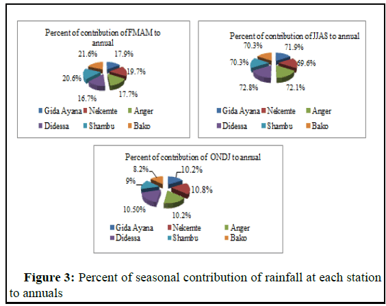
Variability of rainfall amount and seasonal contributions: The kiremt (JJAS) season rainfall contribution ranges from (69.6% to 72.8 %) of the annual rainfall whereas the Belg and Bega season contributes to the tune of 16.7% to 21.6% and 8.2% to 10.9% of the annual rainfall in the Anger sub-basin in all agro-ecological zone (Table 4). This result agrees with the findings of as they report the main seasons contributed the highest contribution to the annual rainfall in the country.
| Station | Jan | Feb | Mar | Apr | May | Jun | July | Aug | Sept | Oct | Nov | Dec |
|---|---|---|---|---|---|---|---|---|---|---|---|---|
| Percent of contribution to annual (%) | ||||||||||||
| G/A | 0.2 | 0.5 | 2.5 | 4.2 | 10.7 | 18.6 | 19.5 | 17.4 | 16.4 | 7.9 | 1.5 | 0.6 |
| Nekemte | 0.4 | 0.7 | 2.5 | 4.7 | 11.8 | 18.7 | 18.9 | 18.4 | 13.6 | 7.2 | 2.3 | 0.9 |
| Anger | 0.3 | 0.7 | 2.4 | 4 | 10.6 | 16.0 | 19.6 | 19.1 | 17.4 | 8.1 | 1.3 | 0.5 |
| Didessa | 0.3 | 0.4 | 1.8 | 3.6 | 10.9 | 19.7 | 19.3 | 17.8 | 16.0 | 8.1 | 1.6 | 0.5 |
| Shambu | 0.7 | 1.3 | 3 | 4.8 | 11.5 | 16.1 | 20.8 | 19.0 | 14.4 | 5.4 | 1.9 | 1.0 |
| Bako | 0.8 | 0.9 | 3.8 | 5.2 | 11.7 | 18.7 | 20.1 | 17.6 | 13.9 | 5.1 | 1.5 | 0.8 |
Table 4: Monthly percentage contribution of rainfall to annual for selected station.
On the other hand the seasonal contribution of each station to annual of Anger sub-basin is also shown diagrammatically in Figure 3 below. As the diagram shows that the sub-basin receives approximately about 10% during ONDJ, 19% in FMAM and more than 70% in JJAS of its annual rainfall at each season. Similar result obtained by over abbay basin presented as more than 70% is achieved during wet season.
Rainfall concentration index: In this study rainfall concentration index analysis was taken to understand the monthly rainfall distribution in the study area for representative station. Accordingly, the monthly rainfall concentration index ranges from (14.5% to 15.1%) which are very close to each other in all stations. The result of analysis shows that Anger sub basin has high concentration or irregular rainfall distribution in monthly pattern. As report shows the rainfall in region is moderate to high monthly rainfall concentration or distribution is there in Setema-Gatiria areas of Jimma.
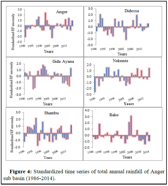
Standardized rainfall anomaly: The standardized rainfall anomaly of representative six rainfall stations in Anger sub-basin is depicted in Figure 4 and Table 5. This finding uses SAI to show the intensity and frequency of drought as well as inter-annual variation of rainfall over the period of (1986-2014).
The study reveals that the positive anomalies ranges from 31% at Bako station to 58.7% at Gida Ayana station, where as the negative anomalies ranges from 41% to 69% at Gida ayana and Bako station respectively (Figure 4). This indicates that the negative anomalies are higher in warm sub-humid lowland and warm moist lowland agroecological zones than in tepid sub-humid mid highland zones of the basin, meaning in the southeastern lowland parts of the basin most of the years maintain rainfall below the average rainfall over 29 years than the Southwestern parts of the basin.
The negative anomaly (dry) in all stations of the sub-basin occurred in 1995, 2001, 2002, 2003 and 2011. This refers that during this years the whole area of the sub basin significantly influenced by lack of rainfall. These finding is supported by Eshetu et al. report that in Jimma area drought is experienced in years in 1984, 1994 2002 and 2003. Additionally, NMA (2007) reported that Ethiopia experienced drought during years in 1983 to 1984, 1987 to 1988, 1990 to 1992, 2000, 2002 and 2003.
| Droug ht category | Extreme drought | Severe drought | Moderate drought | Mild drought | Normal | Severe wet | Extreme wet | |
|---|---|---|---|---|---|---|---|---|
| SAI range | -2 or less | -1.5 to -1.99 | -1 to -1.49 | -0.99 to 0 | 0 to 1.49 | 1.5 to1.99 | 2 or more | |
| Anger | Freq | 2 | 0 | 0 | 15 | 10 | 1 | 1 |
| % | 6.9 | 0 | 0 | 51.7 | 34.5 | 3.4 | 3.4 | |
| Didessa | Freq | 1 | 1 | 2 | 14 | 9 | 0 | 2 |
| % | 3.5 | 3.5 | 6.9 | 48.3 | 31 | 0 | 6.9 | |
| Nekemte | Freq | 1 | 2 | 1 | 11 | 11 | 3 | 0 |
| % | 3.4 | 6.9 | 3.4 | 37.9 | 37.9 | 10.3 | 0 | |
| Bako | Freq | 0 | 0 | 0 | 20 | 6 | 1 | 2 |
| % | 0 | 0 | 0 | 69 | 20.7 | 3.4 | 6.9 | |
| Shambu | Freq | 0 | 1 | 4 | 11 | 11 | 1 | 1 |
| % | 0 | 3.4 | 13.8 | 37.9 | 37.9 | 3.4 | 3.4 | |
| Gida Ayana | Freq | 1 | 2 | 3 | 6 | 15 | 2 | 0 |
| % | 3.4 | 6.9 | 10.3 | 20.7 | 51.7 | 6.9 | 0 | |
Table 5: Standardized rainfall indices with the frequency and percentages of occurrence over the period of 1986-2014 in Anger sub-basin.
According to McKee standardized anomaly index classification from the above Table 5 during 1986, 1991, 2002 periods the study area is characterized by extreme drought in Anger, Didessa, Nekemte and Gida Ayana. However, no extreme drought happened in the area covered by Shambu and Bako stations. Meanwhile in 1988, 1993, 1998, 2004, 2005 and 2008 period’s shows that Anger sub basin is characterized by extreme wet.
The SAI ranges (-1.5 to -1.99) occurred in 1992, 1994, 1995, 1998, 2002 and 2014 in the basin shows that severe drought is experienced in some parts of the basin around Shambu, GA, Nekemte and Didessa representative stations while no severe drought is takes place in Anger and Bako stations according to the result obtained. However, severe wet (1.5 to 1.99) occurred in almost all stations except Didessa during 1989, 1992, 1993, 1994, 1997, 1998 and 2014 time periods.
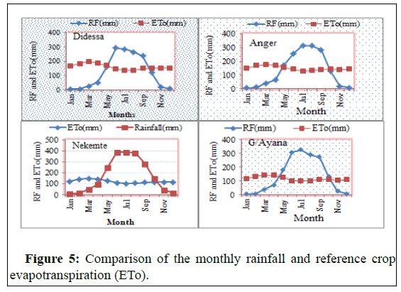
Comparison of Rainfall and Evapo-transpiration in anger subbasin: As shown in Figure 5 in Anger sub-basin the mean monthly evapotranspiration ranges from 101.8 mm/month at Gida Ayana to 195.2 mm/month at Didessa station. Low mean monthly evapotranspiration is occurred during June, July and August which varies from 101.8 mm to 147.2 mm/month.
The mean monthly rainfall exceeds reference crop evapotranspiration from months May to October in tepid sub-humid mid-highlands at Nekemte and Gida Ayana, as well as, from May to September in warm sub-humid lowland and warm moist lowlands at Didessa and Anger stations. This indicates that the southeastern highlands of the basin have high rainfall with low evapotranspiration as compared to the southwestern parts of the basin.
As reported on Abay Basin Atlas, the annual evapotranspiration of Anger sub-basin varies from 1360 mm/year to 1925 mm/year in 2009. However, according to the current study the annual evapotranspiration varies from 1222 mm/year to 2342 mm/year. This indicates how variable climate in the study area. For the rest months where rainfall is below the evapotranspiration water deficit is there which hinder the production of crops that have long length of growing season.
Trend analysis
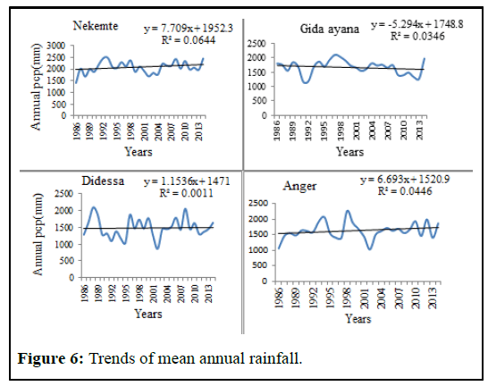
Rainfall trend: The Mann-Kendall analytical results for agroecological zones rainfall trend presented in Table 6 and Figure 6. The result for all the agro-ecological zones demonstrates the trend of annual rainfall is not statistically significant (P>0.05).
However, positive trend of rainfall is observed in representative stations in warm moist lowlands and warm sub-humid lowlands zones. But in tepid sub humid mid-highlands positive trend have been seen in Nekemte station and negative trend is observed in Gida Ayana station.
| Stations | Mann-Kendall trend | Z | Sen's slope estimate | |||
|---|---|---|---|---|---|---|
| First year | Last year | N | Significance | Q (mm/year) | ||
| Anger | 1986 | 2014 | 29 | 1.22 | - | 7.202 |
| Didessa | 1986 | 2014 | 29 | 0.43 | - | 3.22 |
| Gida ayana | 1986 | 2014 | 29 | -1.29 | - | -8.723 |
| Nekemte | 1986 | 2014 | 29 | 0.99 | - | 6.183 |
Table 6: Trend analysis of rainfall of representative stations in AEZ of Anger sub-basin.
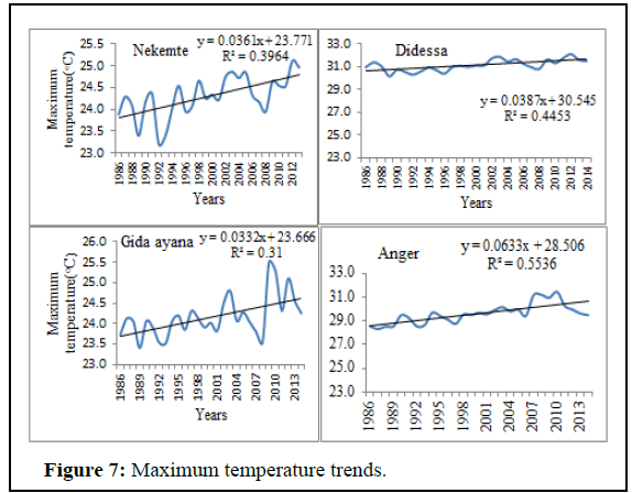
Maximum temperatures trend: For maximum temperature the result of trend analysis shows that in all agro-ecological zones increasing trends is observed as shown as in Figure 7 of Anger station. Table 7 shows statistically significant trend with P>95% in tepid subhumid mid highlands for Nekemte and Gida Ayana stations and warm moist lowlands for Didessa station.
Also, significant increasing trend is noticed in Anger station which represents warm sub-humid lowland zones. Additionally, in other stations an increasing trend with magnitude of 0.041, 0.032, 0.027 and 0.058°C/year is observed in Didessa, Gida Ayana, Nekemte and Anger in that order.
| Stations | Mann-Kendall trend | Z | Sen's slope estimate | |||
|---|---|---|---|---|---|---|
| First year | Last year | N | Significance | Q (mm/year) | ||
| Anger | 1986 | 2014 | 29 | 1.03 | - | 0.058 |
| Didessa | 1986 | 2014 | 29 | 3.73 | *** | 0.041 |
| Gida Ayana | 1986 | 2014 | 29 | 2.64 | ** | 0.032 |
| Nekemte | 1986 | 2014 | 29 | 3.02 | ** | 0.027 |
Note: *** and** indicate that the trends are significant at 99% and 95% level of confidence respectively
Table 7: Historical trend analysis of maximum temperatures of representative stations in agro-ecological zones of anger sub-basin.
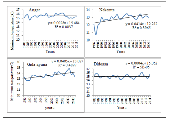
Minimum temperature trend: The trend analysis of minimum temperature over the given period (Table 8 and Figure 8) shows that in lowland agro-ecological zones (warm moist and warm sub-humid) statistically non-significant trends are observed. However, in tepid sub-humid mid highlands the two representative stations an increasing trend with statistically significant at α=0.01 significance level.
| Stations | Mann-Kendall trend | Z | Sen's slope estimate | |||
|---|---|---|---|---|---|---|
| First year | Last year | N | Significance | Q (mm/year) | ||
| Anger | 1986 | 2014 | 29 | 0.06 | - | 0.002 |
| Didessa | 1986 | 2014 | 29 | 0.09 | - | 0.001 |
| Gida Ayana | 1986 | 2014 | 29 | 3.81 | *** | 0.032 |
| Nekemte | 1986 | 2014 | 29 | 3.55 | *** | 0.041 |
Note: ***Indicate that the trends are significant at 99% level of confidence, respectively
Table 8: Historical trend analysis of minimum temperatures of representative stations in agro-ecological zones of Anger sub-basin.
On the whole Anger sub-basin in tepid sub-humid mid highlands the minimum temperature is on upward slopping at the rate of 0.032°C-0.041°C/year; while in warm moist lowland it increasing by 0.001°C/year and increased by 0.002°C/year in case of warm sub-humid lowlands, as-represented by Anger station (Table 8). In line with this, Taddesse and Tessema et al. had reported an increased temperature in Ethiopia during the last decades.
Probability of dry spell risk
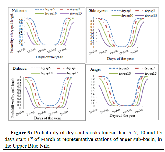
The general over view of dry spell risks from the beginning of March (DOY 61) to end of September (DOY 274) in Anger sub-basin over the 29 years period considering chance of occurrence exceeding 5, 7, 10 or 15 days are showed in Figure 9. As seen shown in Figure 9 below the probability of dry spells longer than 15 days that forms part of the rainy season (March-September).
For the three agro-ecological zones in point, the probability of dry spells longer than 15 days in March is less than 60%, at Nekemte and Gida Ayana stations where as it is less than 70% in Anger and Didessa stations. The degree of dry spell probability descends down to zero from half of April to end of September in Gida Ayana, Anger and Nekemte stations. However, in Nekemte stations it descends to zero earlier. But Didessa stations reflect that during the rainy month’s probability of dry spell longer than 5 days is not below 10%.
The same Figure also demonstrates how the probability of 5 and 7 days of dry spell curves stays at the value of 1.0 during the earlier months. All the dry spell length probability curves converge to their minimum only during the peak rain period (June to August or DOY 153-244) for all stations. The figure also shows dry spell probability curves invariably turn upward again starting varies from end of August to end of end of September (242-274 DOY). In warm moist lowland agro-ecological zone which is represented by Didessa station starts upward earlier than other stations indicating the shorter rainy season.
The probability of occurrence of short dry spell days is higher than the prolonged dry spells (Figure 9). The probability of occurrence of five days dry spell is the highest, followed by seven and ten dry spells in the growing season. Despite the highest probability of occurrence, its consequence on crop production may be negligible compared to the longer dry spells. The reason behind including the ‘dry spell length’ conditions into the later months of the growing season is to provide a complete picture of how the dry spell length of various magnitudes are distributed during the entire growing season.
Conclusion
Local climate characterization was done based on the long term historical data of 29 years using Instat software and it has been reported that in all agro-ecological zones of the sub-basin start of the season variable with CV varies from (8.4% to 13.5%) not more than 15 DOY in all representative stations and end of the season varies with the CV of (3.3% to 4.3%) in all stations. However, the duration of the rainy season varies from (119 to 233 DOY) days over the whole watershed which is enough for long growing season crops. Therefore, over Anger sub-basin end of the season is less variable than start and duration of the rainy seasons.
Results of seasonal climate data analysis revealed spatially, the mean annual ranges between 1246.8 mm to 2067.9 mm over the Anger sub-basin. The mean Kiremt season rain varies from 873 mm to 1438.4 mm with CV value varies from (12.2% to 31.7%). It is lower when compared to the CV values the Belg season ranges (30.1% to 54.9%) and Bega season from (45.5% to 63%). This indicates that Kiremt rain was less variable than Belg and Bega rain. Rainfall concentration index ranges from (14.5% to 15.1%) indicating irregular rainfall distribution in monthly pattern and standardized rainfall anomaly shows that dry condition are higher in warm sub-humid lowland and warm moist lowland agro-ecological zones than in tepid sub-humid mid highland zones of the sub-basin. Trend analysis also revealed that increasing trend of rainfall in all stations except Gida Ayana where as significant increasing trend is observed over the study area in both maximum and minimum temperatures. The degree of dry spell probability descends down to zero from half of April to end of September in tepid sub-humid mid highlands and warm sub-humid lowlands, however, in warm moist lowland the rainy month’s probability of dry spell longer than 5 days is not below 10%. In conclusion, dry spell length probability curves converge to their minimum only during the peak rain period (June to August or DOY 153-244) in all agro-ecological zones.
References
- Amekudzi LK, Yamba EI, Preko K, Asare EO, Aryee J, et al. (2015) Variabilities in rainfall onset, cessation and length of rainy season for the various agro-ecological zones of Ghana. Climate 3: 416-434.
- Ayalew D, Tesfaye K, Mamo G, Yitaferu B, Bayu W (2012) Variability of rainfall and its current trend in Amhara region, Ethiopia. Afr J Agric Res 127: 1475-1486.
- Braganza K, Karoly D, Hirst A, Mann M, Stott P, et al. (2003) Simple indices of global climate variability and change: Part I-variability and correlation structure. Clim Dyn 20: 491-502
- de Luis M, Raventos J, Gonzalez‐Hidalgo JC, Sanchez JR, Cortina J (2000) Spatial of rainfall Spatial analysis trends in the region of Valencia (East Spain). Int J Climatol: J Royal Meteorol Soc 20: 1451-1469.
- Eshetu G, Johansson T, Garedew W (2016) Rainfall trend and variability analysis in Setema-Gatira area of Jimma, Southwestern Ethiopia. Afr J Agric Res 11: 3037-345.
- Hadgu G, Tesfaye K, Mamo G (2015) Analysis of climate change in Northern Ethiopia: Implications for agricultural production. Theor Appl Climatol 121: 733-747.
- Douglas EM, Vogel RM, Kroll CN (2000) Trends in floods and low flows in the United States: Impact of spatial correlation. J Hydrol 240: 90-105.
- Hare JD, Andreadis TG (1983) Variation in the susceptibility of Leptinotarsa decemlineata (Coleoptera: Chrysomelidae) when reared on different host plants to the fungal pathogen, Beauveria bassiana in the field and laboratory. Environ Entomol 12: 1892-1897.
- Sifer K, Yemenu F, Kebede A, Quarshi S (2016) Wet and dry spell analysis for decision making in agricultural water management in the eastern part of Ethiopia, West Haraghe. Int J Water Res Environ Eng 8: 92-96.
- Viste E, Korecha D, Sorteberg A (2013) Recent drought and precipitation tendencies in Ethiopia. Theor Appl Climatol 112: 535-551.
- Lemma M, Alemie A, Habtu S, Lemma C (2016) Analyzing the impacts of on onset, length of growing period and dry spell length on chickpea production in Adaa District (East Showa zone) of Ethiopia. J Earth Sci Clim Change 7: 349.
- Longobardi A, Villani P (2010) Trend analysis of annual and seasonal rainfall time series in the Mediterranean area. Int J Climatol 30: 1538-1546.
- Mohsin T, Gough WA (2010) Trend analysis of long-term temperature time series in the Greater Toronto Area (GTA). Theor Appl Climatol 101: 311-327.
- Partal T, Kahya E (2006) Trend analysis in Turkish precipitation data. Hydrol Process: Int J 20: 2011-2026.
- Tessema YA, Aweke CS, Endris GS (2013) Understanding the process of adaptation to climate change by small-holder farmers: The case of east Hararghe Zone, Ethiopia. Agric Food Econ 1: S 1-7.
Citation: Boru GF, Gonfa ZB, Diga GM (2023) Climate Characterization and Variability in Agro-Ecological Zones of Anger Sub-Basin, Nile Basin of Ethiopia. Environ Pollut Climate Change 7: 344. DOI: 10.4172/2573-458X.1000348
Copyright: © 2023 Boru GF, et al. This is an open-access article distributed under the terms of the Creative Commons Attribution License, which permits unrestricted use, distribution and reproduction in any medium, provided the original author and source are credited.
Select your language of interest to view the total content in your interested language
Share This Article
Recommended Journals
Open Access Journals
Article Tools
Article Usage
- Total views: 1405
- [From(publication date): 0-2023 - Jul 02, 2025]
- Breakdown by view type
- HTML page views: 1086
- PDF downloads: 319

