Climate Change Impact on Rainfall and Temperature Distributions Over West Africa from Three IPCC Scenarios
Received: 15-Apr-2018 / Accepted Date: 05-Jun-2018 / Published Date: 12-Jun-2018 DOI: 10.4172/2157-7617.1000476
Abstract
The study investigates the climate change impact on monthly and seasonal distribution of rainfall and temperature of three scenarios of the Intergovernmental Panel on Climate Change (IPCC) between year 2000 and 2099. The analysis considered two climatic periods which are 2000 to 2029 as present and 2070 to 2099 as future. The ten-year mean (decadal) analyses of these two parameters were also performed. The result showed that temperature increases over West Africa countries in all the months under each of the scenarios. Scenario A2 with the highest emission of 800 ppm shows the highest increase of temperature and rainfall over West Africa followed by scenario A1B with emission of 720 ppm and the least is that of B1 with the lowest emission of 550 ppm. The result also showed that rainfall increases over most part of West Africa in all the scenarios with the exception of coastline that a little decrease in amount of rainfall was estimated. However, the decadal analysis shows that there is a gradual and almost consistent increase in temperature and rainfall over West Africa. Monthly mean values of scenario B1 estimated higher in all the months than its scenario A1B counterpart while those of A1B are also higher than those of scenario B1. The result implies that the higher the emission, the higher is the temperature which leads to warmer future and most likely the more rainfall and hence likelihood of flooding, more occurrence of heat wave and other high temperature related problems. It therefore recommended that IPCC regulation to reduce emission should be strictly adhered to by all countries so that the world can have a better future to dwell in.
Keywords: Climate change impact; Scenario; Emission; Temperature; Rainfall; Present and future climate
Introduction
Global mean surface air temperature has been steadily rising since 1950s, primarily attributed to increase in greenhouse gases emission. This impact of global warming is not limited to global and regional changes in temperature alone, it also has significant impact on regional rainfall patterns, which may not only alter rainfall amount but rainfall distributions and patterns. Similarly, the Intergovernmental Panel on Climate Change [1] reported to the United Nations that the earth’s climate system is undoubtedly getting warmer. Although specific individual events can’t be directly linked to global warming, the IPCC has noted many indications of climate change around the world such as: retreating mountain glaciers on all continents; thinning ice caps in the Arctic and Antarctic; rising sea-about 6-7 inches in the 20th century; more frequent heavy precipitation events (rainstorms, floods or snowstorms) in many areas; more intense and longer droughts over wider areas, especially in the tropics and subtropics; more frequent and stronger occurrences of hurricane/typhoons. Our main source of information about the past climate change comes from observations while information about possible future climate changes is obtained through numerical climate models. An accumulation of body of evidence suggests that the decrease of the atmospheric greenhouse gas concentrations could increase the frequency of dry spell in some regions of the globe; physical considerations imply that the sensitivity of heavy precipitation may be determined primarily by the change in the atmospheric moisture transport capacity (governed by the clausiusclapeyron relation) rather than the change in the mean precipitation and evaporation [2-4].
The moistening of the atmosphere could result in progressive larger frequency of high precipitation intensities and increase could even occur in the regions where mean precipitation decreases [5-7]. However, some global warming experiments with general circulation models (GCMs) show an increase in precipitation extremes over many areas of the globe [8-13]. The details of the distribution and the magnitude of the change vary between models. Climate change has a strong influence on agricultural production, considered as the most weather-dependent of all human activities [14,15], with socio-economic impacts whose severity varies from one region to another [16]. There is a vital need for trustworthy prediction of sub-Saharan West African climate since the region depends highly on agricultural products and is also very prone to devastating droughts. Simulations from the majority of the atmosphere-ocean general circulation models (AOGCMs) run for the Fourth Assessment Report of the Intergovernmental Panel on Climate Change (IPCC 2007) produce weak annual-mean rainfall projection over this region. One model produces extreme rainfall decrease, but these outlier model simulations may not be accurate [17,18]. Many of the AOGCMs validate poorly over northern Africa, e.g. incorrectly simulating the summer precipitation maximum over the Gulf of Guinea instead of simulating it over the continent and misrepresenting basic circulation features of the West African monsoon [17].
Patricola and Cook [19] developed an approach for projecting future climate that combines the advantages of global and regional. Although, improved information on regional climate change can be achieved through different regionalization techniques such as including high-resolution and variable resolution AGCMs [20], nested regional climate models or RCMs [21] and statistical downscaling [22], nevertheless, driving GCM embedded with any of climate change scenarios provides the initial and boundary value for any of these regionalization techniques. Responses of West African temperature and rainfall distribution to some of these IPCC’s scenarios are hereby fully studied. This study hereby investigates possible future temperature and rainfall trends and distribution over the entire West Africa during the two major seasons and transition periods between these seasons with three of the four major IPCC scenarios. For preliminary investigation of different IPCC’s scenarios, this study therefore compares climate change impacts on rainfall and temperature distribution over West Africa as estimated by CSIRO-Mk3.5 global model. Also, estimated the decadal changes of these two parameters for each of the IPCC scenarios over West Africa; and proposed appropriate recommendation to the policy makers based on the study.
Materials and Methods
Data and method of analysis
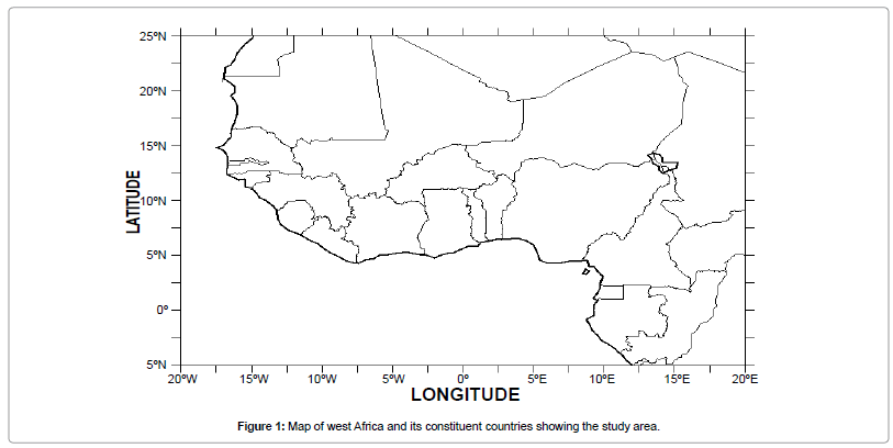
The present study concentrated on West Africa and its surrounding territories. It is from 20°W to 20°E and from 5°S to 25°N as shown in Figure 1. The data used was from archive of Multi-model dataset (MMD) under the Program for Climate Model Diagnosis and Intercomparison (PCMDI). It comprises of monthly precipitation and temperature data for three IPCC’s scenarios. These scenarios are A1B, A2 and B1 as defined by Intergovernmental Panel on Climate Change (IPCC). The general circulation model (or global climate model, GCM) used for the simulation is Mk3.5 climate model of the Commonwealth Scientific and Industrial Research Organization (CSIRO), Australia. The CSIRO Mk3.0 climate system model is documented by Gordon [23]. Mk3.0 model is based on the Mk2 model with major numerical, computational and parameterization improvements. A number of physical parameterization and numerical improvements were made to the Mk3.0 model to produce the Mk3.5 version used in the study. These include a scheme to control the strength of the ocean eddy-induced transport, vertical Ocean mixing due to wind-generated turbulent kinetic energy and an improved runoff and river routing method. The resolution of the data is 1.875° longitude by 1.850° latitude. The carbon dioxide concentration of each of the scenarios as follows A1B (720 ppm), A2 (800 ppm), B1 (550 ppm).
Method of analysis
Global daily temperature and precipitation data were gotten from the CSIRO archive for 100 years from 2000 to 2099. Climate change analysis was performed for two climatic periods of 2000 to 2029, this serves as present while 2070-2099 as future. Monthly means for each month over thirty years of the two climatic periods were computed as follows:
 (1)
(1)
Change in climate over West Africa is hereby defined as follows:
Change=Future – Present (2)
Spatial and temporal variation of the monthly rainfall amount in mm/day and temperature in degree Celsius were then studied and compared. Seasonal variations of the dry season (December, January and February) denotes as DJF, transition from dry to wet (March, April and May) denotes as MAM, wet season (June, July and August) denotes as JJA and transition from wet to dry season (September, October and November) denotes as SON were plotted and compared for each of the three IPCC scenarios.
Since the whole data set covers a hundred-year period, it was deemed fit to also look at the behavior of the climate and how it responds to the different carbon dioxide concentrations (forcing) on decadal basis. Therefore, ten years averages of precipitation and temperature for these three IPCC scenarios were also looked into on monthly basis. It should be noted that decade in this study refers to an average of ten years period, so that decade one is from year 2000 to year 2009 while decade ten is from 2090 to 2099. For each decade, the monthly values represent the average of such month for the ten years that make up that decade.
Results and Discussions
Seasonal change studies and scenarios comparisons for temperature
Figure 2 is the spatial distribution of temperature in Kelvin over West African sub-region. The first column is the variation for the first climatic period (present climate, 2000 to 2029) while the second column is the second climatic period (future climate, 2070 to 2099) for the peak of dry season (December, January and February) otherwise referred to as DJF. The first, second and third row is respectively for scenario A1B, A2 and B1 as indicated on the Figure. It is observed that the temperature pattern will not change from the present (first climatic period) to the future (the second climatic period), but throughout the entire West Arica, there is a general temperature increase. Looking at the scenario A1B, the minimum temperature over Southern part of West Africa located at around 10°N is 295K (22°C) in the present but has increased to 301K (18°C) in the future. The respective values of these for A2 are 291K and 303K (18°C and 30°C) while those of B1 are 297K and 299K (24°C and 26°C). This shows that climate change during this period DJF is real and scenario B1 gives the least temperature change, while both A1B and A2 gives a change of 4°C.
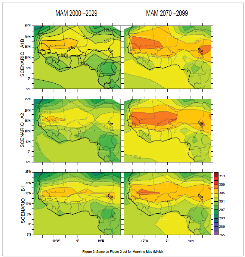
Figure 3 is similar to Figure 2 but it is for March, April and May. It is observed that the temperature pattern will change from the present climatic period to the future one. The warm (high temperature) center located at latitude 15oN in the present has reproduced two warm centers, one around 10oW while the second one is around 15oE. It should be noted that this is the transition period from dry to wet season over some parts of West Africa and therefore the temperature range is not too wide from the North to the South of West Africa. Meanwhile, evidence of climate change is still showing that there is a general temperature increase of about 2°C over major part of West Africa.
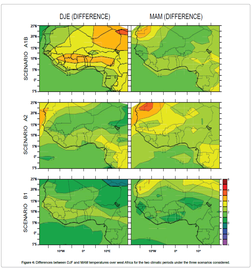
For clearer understanding and quantitative description of climate change, the difference between the present and future climatic periods for December, January and February on one part and that of March to May on the other part under the three scenarios are presented in Figure 4. It was obvious that there is a general increase in temperature over West Africa with varying degree of increase in different part of West Africa. The change is more pronounced to the northern part of West Africa and around the latitudinal belt of 10°N. The change in temperature pattern observed between 10°N and 15°N should be noted as this is the location of African Easterly Jet (AEJ) that is responsible for initiation of organized mesoscale convective systems. AEJ are being formed by the meridional reversed temperature gradients between the equator and around 15°N but mostly pronounced between 10°N and 15°N. It should also be noted that the increase is also observed over the Atlantic Ocean.
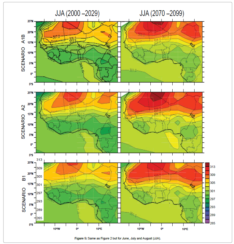
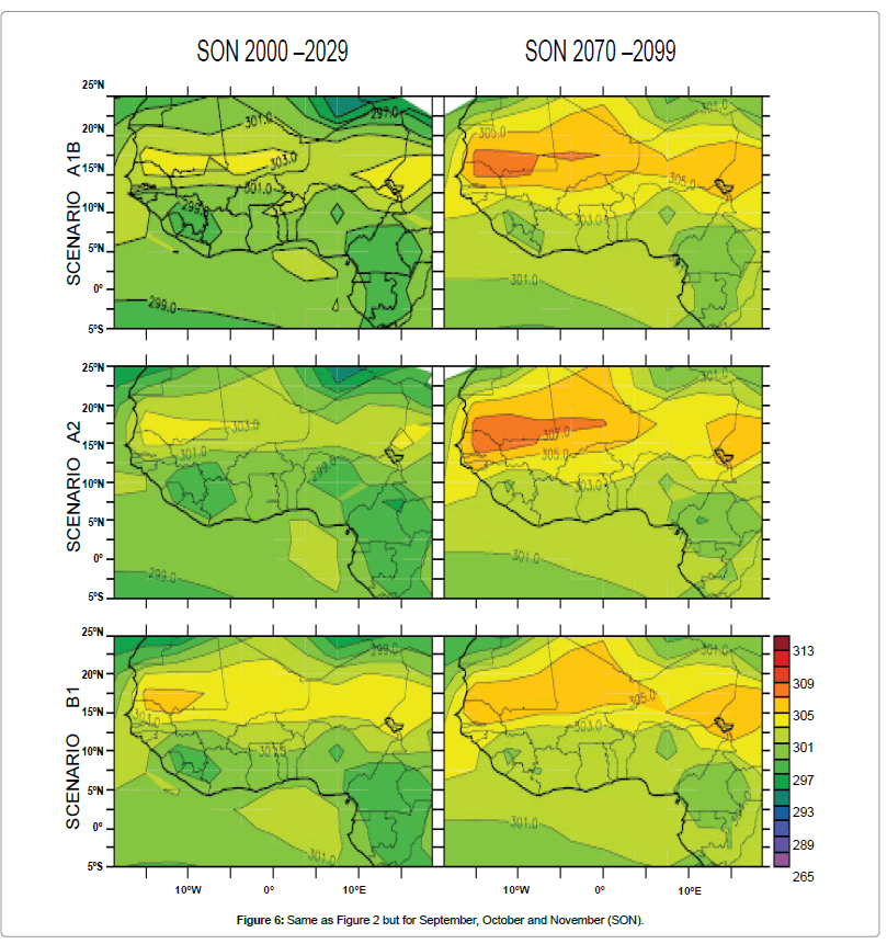
Figure 5 shows the distribution of temperature in June, July and August (JJA) for the two periods. As the Inter-Tropical Discontinuity (ITD) moves northwards to its northernmost position during this period, the warm centre also moves northward. The patterns for the three scenarios are very alike apart from the fact that the second warm center in A2 is more pronounced than those of B1 and A1B in present climate. There is also a general increase in JJA temperature of the entire West Africa. In the future climate, the warm centre is higher and the second warm centre is more pronounced in all the three scenarios. The cold region (area of low temperature values) between 5°N and 10°N observed in the present climate in all the three scenarios is seen to have been divided into separate but opposing centers in A2 and B1, while that of A1B remains as one. A similar analysis for September, October and November (SON) which is the transition from wet to dry season over West Africa is shown in Figure 6. For the three scenarios, the patterns do not change much, all the warm and cold centers in the present climate are also observed in the future climate other than the warm and even cold centers in the present become warmer and wider in the future. Throughout the sub-region, there is general temperature increase. Mostly obvious is the warm centre in scenario A2 where the value of 303K (30°C) becomes 307K (34°C) and even wider.
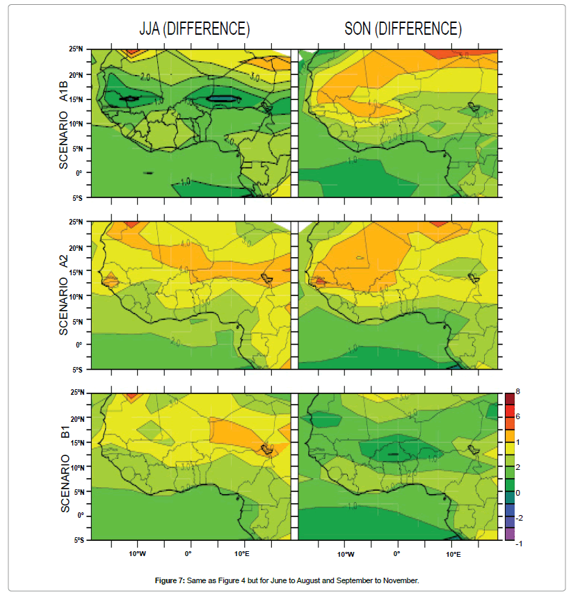
In order to quantify the spatial distribution in the increase of temperature over West Africa for JJA and SON seasons, Figure 7 is hereby presented. It is observed that in JJA, the difference in A2 case is the highest and it is 3-4°C over major parts of West Africa. Also, in SON, A2 again has the highest temperature increment among the three scenarios; it is also around 3-4°C over most part of West Africa. For scenario A1B, the increment in SON is more than that of JJA while reverse is the case for scenario B1. In SON season, A1B is very high having a range of 2-4°C over West Africa but a range 2-3°C over West Africa. For scenario A1B, the difference is in the range of 2-4°C in JJA but between 1 and 2°C in SON. So far so good, Scenario A2 has given the highest change in all the seasons while that of B1 has given the lowest change for all the seasons over West Africa.
Seasonal change studies and scenarios comparisons for rainfall
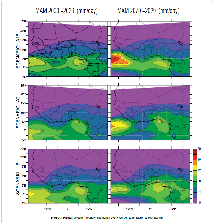
In order to properly study the change and scenarios inter-comparisons over West Africa, the transition from dry to wet season which comprises of March, April and May (MAM) and the wet season comprising of June, July and August (JJA) over West Africa are considered. September to November (SON) will also be considered because area south of 9-10°N experiences its second rainfall maximum in September and this area still has some precipitation in October and sometimes in November. This is because apart from the coastal area, there is virtually no rainfall over the entire West Africa in January, February and December and therefore the DJF is not considered. Figure 8 shows the distribution of rainfall in mm/day for March to May for the two climatic periods and the three scenarios being considered. It is obvious that, the rainfall distribution over the two periods for each of the scenarios is the same. It should be noted that around this time of the year, area south of about 10°N will be having rainfall, therefore, for the present and future climates, the change was clearly observed over the continent of West Africa but greater over the ocean. The present study does not really look at the change over the ocean. The change over land is between 0 and 1 mm.
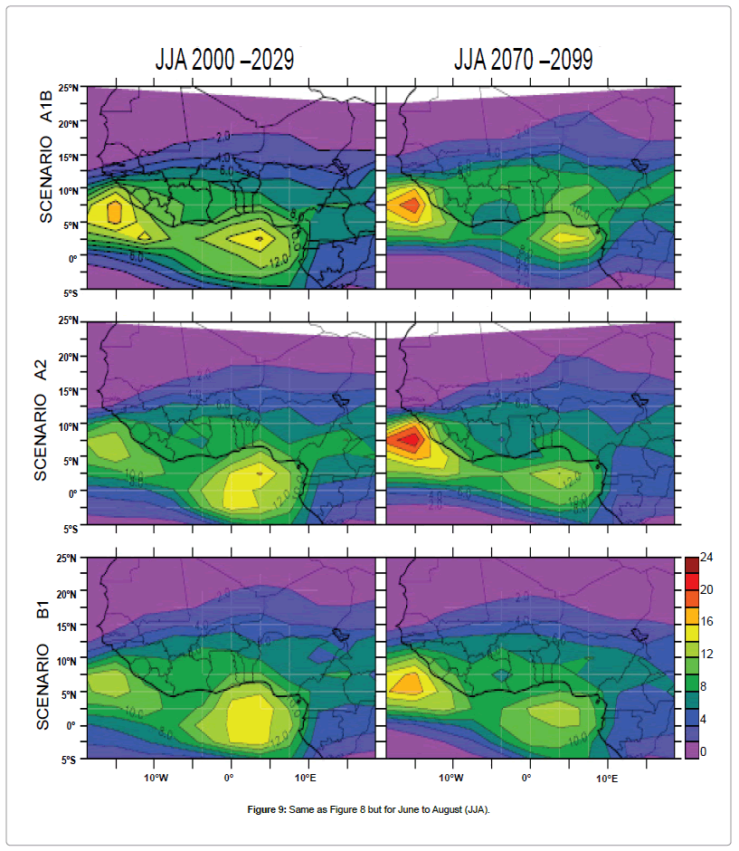
During the rainy season which is the month of June to August, the rainfall patterns were observed to be the same for each of the scenarios. As presented in Figure 9. There are always two rainfall maxima; one is centered on 15°W, 6°N while the other is centered on 5°E, 0°N. It is observed that the former is seriously intensified in the future climate for both A1B and A2 scenarios while the increment over scenario B1 is just about 4 mm/day. The second peak is rather constant. Over the continental land, the change is not much and will be discussed briefly. Generally, the patterns are the same apart from the fact that the low in scenario A1b in present climate is not pronounced as it is in the future one. This minimum between the two maxima is centered on 5°E, 5°N. It is also a little bit shown in scenario B1.
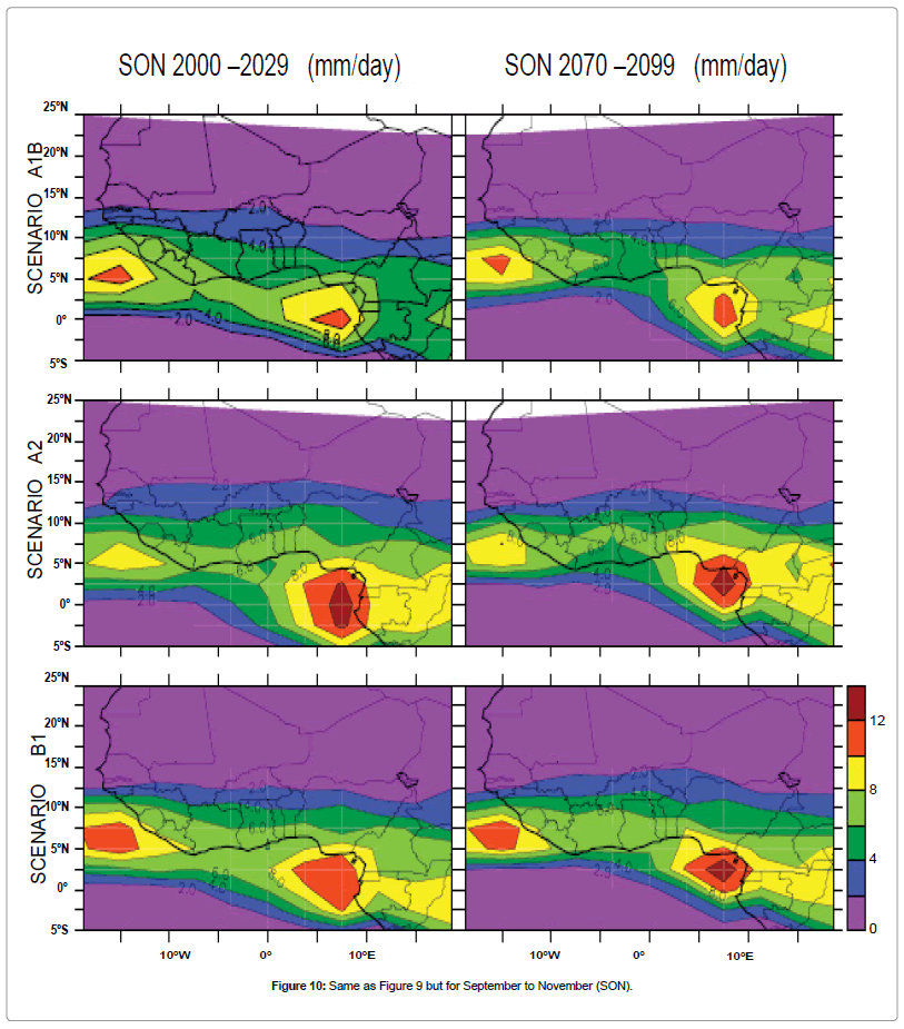
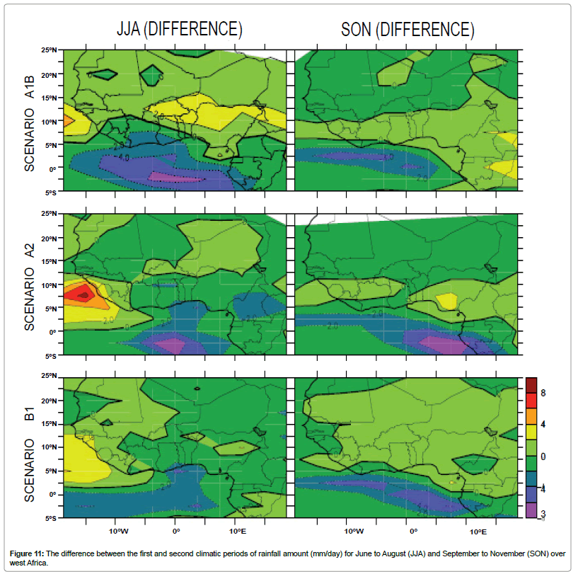
Finally, on seasonal variation studies, the SON rainfall distribution is depicted on Figure 10. Since the ITD has retreated southward at this time, rainfall is only restricted to area south of 13°N. The patterns are the same over the two periods being considered. In fact, the sizes of the high centers are almost the same for each of the scenarios. There seems to be no significant change in precipitation amount over West Africa during this season. The change can therefore be studied if the difference of the two climatic periods were looked at in depth. Presented in Figure 11 is the difference between the present and future climates of the JJA and SON rainfall amounts. The negative change that signifies decrease in rainfall amount is mostly observed over the ocean and this means that rainfall amount over the Atlantic Ocean will be reduced in the future, as observed in the three scenarios. Over the sub-continent of West Africa, the change in rainfall amount during JJA between is generally between 0 and 4, while along and close to the coastline, there is decrease in rainfall amount ranging from 0 and 2 mm increase of rainfall usually between 0-2 mm/day. During SON for A1B, there is an increase between 0-2 mm/day from the coastline to around 10°N, whereas, north of this, there is a decrease in rainfall amount of between 0-2 mm/day. Similar result is also observed for the other two scenarios, the increments in rainfall during JJA for the other two scenarios are not as pronounced as in A1b [24-26].
Decadal studies of temperature changes
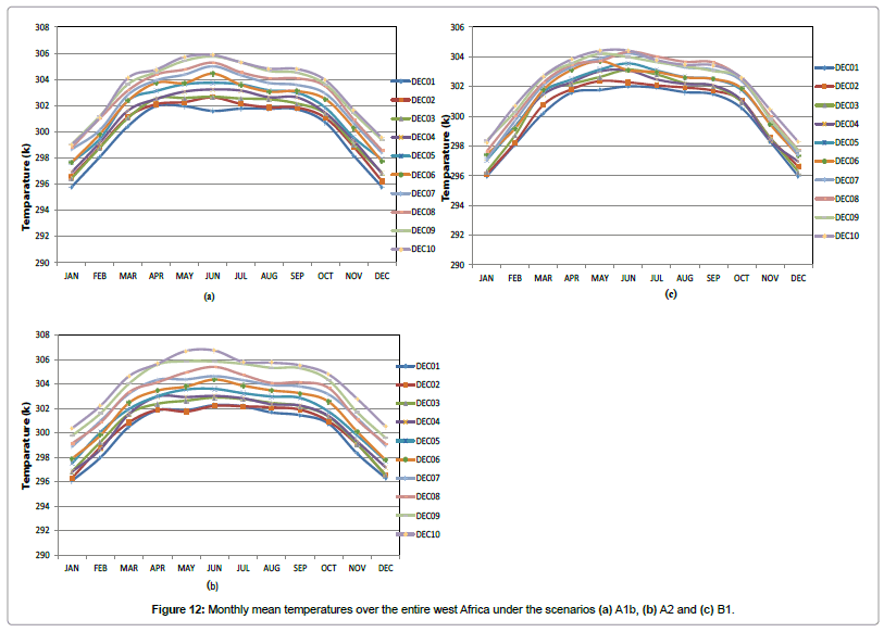
Decadal studies of temperature changes Shown in Figures 12a-12c are the decadal averages series of temperature over the study area. Scenario A1B is in 12(a) while scenario A2 is depicted in 12(b) and scenario B1 in 12(c). Generally, it is seen that the temperature value over the entire study area starts to increase steadily from the first decade up to the tenth decade in the three scenarios. Comparing the three figures, it is depicted that scenario A2 has the highest tenth decade temperature value of about 306.7K (33.55°C) from the months of May and June while the next high is scenario A1B with maximum value of about 305.8K (32.65°C) for the month of May and June, the corresponding values for scenario B1 is the least and these are around 304.4K (31.25°C). The most striking feature common to all these figures is that there is a gradual increase of temperature as the century proceeds. All these supports the fact that there is a holistic increase of temperature form the very first decade to the last decade of this century. Also, apart from comparing the maximum values of temperatures for each of the scenarios, it is also observed that the monthly temperatures under scenario A2 are generally higher than those of A1B while those of A1B are also generally higher the those of B1.
Conclusion
Climate change is an inevitable occurrence that has started to manifest. Using a hundred years of monthly rainfall and temperature data over West Africa for three different IPCC scenarios, the first thirty years and the last thirty years were taken as the present and future climatic period. The scenarios are A1B with emission of 720 ppm, A2 with emission of 800 ppm and B1 with emission 550 ppm. Ten years averages were also computed in order to study the trend in change of each of the three scenarios considered and then perform their comparison of the impact of each of the scenarios. The study showed that the temperature patterns of the present and future climates for both rainfall and temperature distribution are alike. However, it has been found out that during JJA, the difference in temperature of A2 scenario is the highest and it is 3-4°C over major parts of West Africa. In SON, A2 also has the highest temperature increment among the three scenarios; it is within 3-4°C over most part of West Africa. For scenario A1B, the increment in SON is more than that of JJA while reverse is the case for scenario B1. In SON season, A1B is very high having a range of 2-4°C over West Africa but a range 2-3°C over West Africa. For scenario A1B, the difference is in the range of 2-4°C in JJA but between 1 – 2°C in SON. It was obvious that there is a general increase in temperature over West Africa with varying degree of increase in different part of West Africa. The change is more pronounced in the northern part of West Africa and around the latitudinal belt of 10°N. It should also be noted that the increase is also observed over the Atlantic Ocean.
The negative change that signifies decrease in rainfall amount is mostly observed over the ocean and this means that rainfall amount over the Atlantic Ocean will be reduced in the future, as observed by all the three scenarios. Over the sub-continent of West Africa, the change in rainfall amount during JJA is generally between 0 and 4 while along and close to the coastline, there is decrease in rainfall amount ranging from 0 and 2 mm. Increase of rainfall usually between 0-2 mm/day. During SON for A1B, there is an increase between 0 and 2 mm from the coastline to around 10°N, whereas North of this, there is a decrease in rainfall amount of between 0 and 2 mm. Similar results is also observed for the other two scenarios. The increments in rainfall during JJA for the other two scenarios are not as pronounced as in A1b. It is also observed that the monthly temperatures under scenario A2 are generally higher than those of A1B while those of A1B are also generally higher than those of B1. Either for dry, wet or transition period, the temperature and rainfall amount under scenario A2 is always higher than that of A1B and that of A1B is always higher than that of B1. This reiterates the fact that the more the release of more of the greenhouse gases then the higher will be the accompanied climate change in terms of temperature and rainfall distribution over West Africa.
It is hereby recommended that the world in general and most especially West African abide by the IPCC standard on reduction of the greenhouse gases. The study can be better improved if the downscaling of this product from global circulation model is done to take into consideration the local effects.
Acknowledgement
The data used for the research was from arc hive of Multi-model dataset (MMD) under the Program for Climate Model Diagnosis and Intercomparison (PCMDI). The author is grateful to the Mk3.5 climate model of the Commonwealth Scientific and Industrial Research Organization (CSIRO), Australia for releasing the simulations on their website. The major part of this work was carried out from the funds of International Council of Science (ICS) that sponsored the author to attend the international conference on “Our Common Future Under Climate Change” (CFCC) in Paris, France in 2015.
References
- IPCC (2007) Fourth assessment report of the intergovernmental panel on climate change p: 546.
- Trenberth KE (1999) Conceptual framework for changes of extremes of the hydrological cycle with climate change. Climate change 42: 327-339.
- Allen MR, Ingram WJ (2002) Constraints on future changes in climate and the hydrologic cycle. Nature 419: 224-232.
- Trenberth KE, Dai A, Rasmussen RM, Parsons DB (2003) The changing character of precipitation. Bull. Ame Met Soc 84: 1205-1217.
- Katz RW, Acero JG (1994) Sensitivity analysis of extreme precipitation events. Int J Climatol 14: 985-999.
- Frei C, Schär C, Lüthi D, Davies HC (1998) Heavy precipitation processes in a warmer climate. Geophys Res Lett 25: 1431-4434.
- Groisman PYA (1999) Changes in the probability of heavy precipitation: Important indicators of climatic change. Clim Change 42: 243-283.
- Kharim VV, Zwiers FW (2000) Changes in the extremes in an ensemble of transient climate simulations with a coupled atmosphere-ocean GCM. J Clim 13: 3760-3788.
- Palmer TN, Räisänen J (2002) Quantifying the risk of extreme seasonal precipitation events in a changing climate. Nature 415: 512-514.
- Semenov VA, Bengtsson L (2002) Secular trend in daily precipitation characteristics: Greenhouse gas simulation with a coupled AOGCM. Clim Dyn 19: 123-140.
- Kiktev D, Sexton DMH, Alexander L, Folland CK (2003) Comparison of modelled and observed trends in indices of daily climate extremes. J clim 16: 3560-3571.
- Watterson IG, Dix MR (2003) Simulated changes due to global warming in daily precipitation means and extremes and their interpretation using the gamma distribution. J Geophys Res 108: 4379.
- Wehner MF (2004) Predicted twenty-first century changes in seasonal extreme precipitation events in the parallel climate model. J Clim 17: 4281-4290.
- Oram PA (1989) Sensitivity of agricultural production to climatic change, an update. Climate food security pp: 25-44
- Hansen JW (2002) Realizing the potential benefits of climate prediction to agriculture: Issues, approaches, challenges. Agric Syst 74: 309-330.
- Ogallo LA, Boulahya MS, Keane T (2000) Applications of seasonal to interannual climate prediction in agricultural planning and operations. Forest Meteorol 103: 159- 166.
- Cook KH, Vizy EK (2006) Coupled model simulations of the West African monsoon system: Twentieth- and twenty-first-century simulations. J Clim 19: 3681-3703.
- Cook KH (2008) Climate change: The mysteries of Sahel droughts. Nat Geosc 1: 647-648.
- Patricola CM, Cook KH (2010) Northern African climate at the end of the twentyfirst century: An integrated application of regional and global climate models. Clim Dyn 35: 193-212.
- Cubasch U, Waszkewitz J, Hegerl G, Perlwitz J (1995) Regional climate changes as simulated in time-slice experiments. Climate Change 31: 273-304.
- Giorgi F, Mearns LO (1999) Introduction to special section: Regional climate modeling revisited. J Geophys Res 104: 6335-6352
- Wilby RL, Wigley TML, Conway D, Jones PD, Hewitson BC, et al. (1998) Statistical downscaling of general climate model output: A comparison of methods. Water Resour Res 34: 2995-3008
- Gordon HB, Rotstayn LD, McGregor JL, Dix MR, Kowalczyk EA, et al. (2002) The CSIRO Mk3 climate system model. CSIRO Atmospheric Research Technical Paper 60: 130.
- Houghton JT (2001) Climate Change: The scientific basis, contribution of working group I to the third assessment report of the governmental panel on climate change, Cambridge University Press, UK.
- IPCC (2001) Climate change. The scientific basis. The Edinburgh Building Shaftesbury Road pp: 881.
- Nakicenovic (2000) IPCC Special report on emissions scenarios, Cambridge University Press, Cambridge UK.
Citation: Adefisan EA (2018) Climate Change Impact on Rainfall and Temperature Distributions Over West Africa from Three IPCC Scenarios. J Earth Sci Clim Change 9: 476. DOI: 10.4172/2157-7617.1000476
Copyright: © 2018 Adefisan EA. This is an open-access article distributed under the terms of the Creative Commons Attribution License, which permits unrestricted use, distribution, and reproduction in any medium, provided the original author and source are credited.
Share This Article
Recommended Journals
Open Access Journals
Article Tools
Article Usage
- Total views: 11650
- [From(publication date): 0-2018 - Apr 03, 2025]
- Breakdown by view type
- HTML page views: 10565
- PDF downloads: 1085

