A Multi-Model Ensembling Approach for Developing Plausible Country scale Climate Change Scenarios for Future
Received: 16-Dec-2013 / Accepted Date: 24-Dec-2013 / Published Date: 02-Jan-2014 DOI: 10.4172/2157-7617.1000179
Abstract
Climate Models are the main tools available for developing projections of climate change in the future. Due to the inter-model differences in internal physics and the process of parameterization of the variables, it is essential to consider the range of projections from different models rather than depending on projection of one climate model only. In this study, multi-model ensemble for future projections of hydro-climatic parameters in terms of precipitation and temperature is developed on monthly resolution for each of the year from 2011 to 2100 with respect to a baseline period of 1971-2000 for Bangladesh. Simulations of four Global Climate Models (GCMs) named CGCM3.1, CCSM3, MIROC3.2 and HadGEM1 are applied for this purpose. An ensemble technique comprising Root Mean Square Error (RMSE) and Weight Factor has been thoroughly discussed. In line with this method, larger weight or preference is given to the GCM that has less error with respect to the observed temperature and precipitation values in the baseline. Prominent large scatters have been observed in the time-series plots for monthly multi-model ensemble precipitation, which resemble highly intensive and more inconsistent temporal precipitation pattern in future. In addition, mean surface temperature is likely to increase invariably in every month.
Keywords: Bangladesh; Climate change; Ensemble; GCM; Multimodel; Precipitation; Temperature
5694Introduction
Climate change has been increasing over the centuries, causing a complete upturned impact on the ecosystem which has influenced the scientists to project the future climate change and to aid the engineers and policy makers in making decisions. Bangladesh, a South Asian country, is already evidencing the adverse impacts of global warming due to climate change. Bangladesh is located between 20° to 26° North and 88° to 92° East [1]. It is bordered on the west, north and east by India, on the south-east by Myanmar, and on the south by the Bay of Bengal. Part of the reason for the susceptibility of Bangladesh to climate change and meteorological-driven disasters is that Bangladesh lies in a sub-tropical region where monsoon weather prevails throughout the year in most parts of the country. Climate change will exacerbate many of the current problems and natural hazards that the country is facing. This study focuses on the possible trends and variability of hydro-meteorological parameters of Bangladesh in the 21st century using recent Global Climate Models (GCMs). GCMs are one of the most widely used mathematical models of global circulation that indicate expectations of future climate conditions. GCMs comprise simplified but systematically rigorous interacting mathematical descriptions of important physical and chemical processes governing climate, including the role of the atmosphere, land, oceans and biological processes. They are the only tools that could provide detailed predictions of future climate change.
In early 1990s, several attempts were initiated to generate climate change scenarios for Bangladesh using available GCMs. The BUPCEARS- CRU [2] study reported 0.5°C to 2.0°C rise in temperature by the year 2030 under ‘business as usual’ scenario of IPCC. The same modeling effort estimated 10 to 15% rise in average monsoon rainfall by the year 2030. Mirza [3] used a number of GCMs and the results have been used for the World Bank Study [4]. By the year 2030, the projected rise in monsoon temperature was 0.7°C with a corresponding rise in winter temperature of 1.3°C. The corresponding rise in rainfall was projected at 11% for monsoon, while a decrease in rainfall by 3% was also projected for winter by the year 2030. Agrawala [5] used the MAGICC driven SCENGEN database to produce a best estimating 11 out of 17 GCMs for projecting Climate Change Scenario in Bangladesh. The results were obtained using IPCC SRES B2 scenario and suggested that annual temperature would increase up to 1.4°C and 2.4°C by the projection year 2050 and 2100. In addition, the dry season precipitation was projected as 1.7% and 3.0% reduced for the projected years, respectively. An increase in monsoon precipitation up to 6.8% and 11.8% by the year 2100 was also found in the study. GCM analysis by Ramamasy [6] indicates that the average temperature of Bangladesh will increase by 1.4°C (± 0.16) by 2050, with more warming for winter than for summer months. Tanner [7] points to average rainfall increasing in Bangladesh during the summer monsoon by around 1-4% by the 2020s, and 2-7% by the 2050s. Hence it can be seen from the range of estimated percentage increases predicted, experts are not sure on the amount of extra rainfall expected but all agree that a wetter Bangladesh is likely in the monsoon due to more rain. The winter drying trend is less certain than that for increasing rainfall in the monsoon [7].
The synthesis of available literatures reveals the fact that not too many precise researches have been accomplished on climate change in Bangladesh. As such, the study area for this research focuses on Bangladesh. Considering the fact that climate modelers do not endorse the use of any single model or method for national-scale assessments of climate change [8], it is found best to validate several models to enable a choice to produce the most appropriate projection to be used in climate-scenario generation in the country-scale resolution.
Methods
GCM simulation for Bangladesh
GCMs’ projections of climate change are the starting point for the future climate scenarios although they lack the regional detail that impact studies generally need. However, four different IPCC ensemble Global Climate Models are selected herein for developing future climate scenarios of Bangladesh. Details of the four models selected are enlisted in Table 1.
| Model ID | Name | Atmosphere-Resolution | Ocean-Resolution |
|---|---|---|---|
| CGCM3.1 (T63) | Canadian Global Coupled Model | T63a (~1.9° x 1.9°) L31b; | (0.9° x 1.4°) L29c; |
| (Version 3.1) | 31 vertical levels; | 29 vertical levels; | |
| top = 1 hPa (~50 Km) | Depth co-ordinate | ||
| CCSM3 | Community Climate System Model | T85 (1.4° x 1.4°) L26 | (0.3°-1° x 1°) L40; |
| (Version 3) | 26 vertical levels | 40 vertical levels; | |
| top = 2.2 hPa (~25 Km) | Depth co-ordinate | ||
| MIROC3.2 (hires)d | Model for Interdisciplinary Research on Climate | T106 (1. 1° X 1.1°) L56 | (0.2° x 0.3°) L47 |
| (Version 3.2) | 56 vertical levels; | 47 vertical levels; | |
| top = 40 km | Sigma/Depth Co-ordinate | ||
| UKMO-HadGEM1 | UK Met Office- | (~1.3° x 1.9°) L38 | (0.3°-1.0° x 1.0°) L40 |
| Hadley Centre Global Environmental Model (Version 1) | 38 vertical levels; | 40 vertical levels; | |
| top = 39.2 km | Depth Co-ordinate |
b, cVertical resolution (L) is the number of vertical levels in the atmosphere and in the ocean respectively
dhires: High resolution
Table 1: Details of Selected GCMs (IPCC-TGICA [10]).
To provide the climate models guidance towards future emission conditions, IPCC scenarios [9,10] are the major tools. Recent greenhouse gas emission trends [11] match or exceed the so-called SRES scenario A1F1. So, A1F1 can be considered as a plausible business-asusual scenario, which also represents a relatively worst case. The more balanced A1B scenario can be considered as a moderate one, featuring a future world of very rapid economic growth balanced across energy sources, clean and resource-efficient technology; while B1 is considered as a best case [12]. In this study, projections are confined only to the hydro-climatic variables, that is, mean surface temperature and total precipitation. Projections of GCMs are developed and compared under a particular emission scenario A1B in monthly resolution. Also the annual projections are compared under multiple scenario conditions of A1B, A2, B1 and COMMIT for one particular model.
Constructing change fields
To examine possible future climatic conditions, one prospect is to develop projections from observed meteorological data [13]. Accordingly, before considering future climate it is important first to characterize the present-day or recent climate in a region– often referred to as the ‘climatological baseline’.
GCMs typically run on horizontal resolution of 200 km or even more. GCM outputs are not generally of sufficient resolution or reliability to be applied directly as the actual prediction of future climatic conditions. There are often significant biases in the model control simulations [8,10,14]. In this regard, it is found usual for baseline observational data, which are commonly in the form of time series of annual or monthly data for several variables over a nonoverlapping period, to be used as a reference for correcting or adjusting future time-series of model outputs.
In this study, year 1971-2000 has been used as the climatological baseline from which the GCM data are referenced. A scenario of future climatology is obtained by adjusting the baseline observations by the difference or ratio between period-averaged (where necessary) results of the GCM control simulation on past baseline years and the corresponding results for the future. Differences are applied for temperature changes while ratios are used for precipitation and evaporation changes, though differences may be preferred in some cases [8]. A pattern of validating model outputs with such differences or ratios of particular climate variables is known as a ‘change field’ or ‘change factor’ [10,15,16]. Thus, the extent of change and variability in any future climatic parameter is taken from the model simulation directly and applied to the baseline observational data to get time-series of future temperature scenario, being called as the ‘Applied Change Field’. This applied change field approach is conceptually simpler and allows direct application of the changes in all climate change projections [8,17-19].
In this study, the projections for annual and monthly average Temperature (T) and Precipitation (P) in Bangladesh, using the four selected GCMs as detailed in Table 1, have been developed for each of the future year of 2011 to 2100, being referenced from 1971-2000 (detail calculation of model bias adjustment is not shown here).
Multi-Model Ensemble (MME)
Temperature and precipitation projections are produced by using the downscaled data from the four models to form an ensemble response for possible climatic change of the country. The expected response can be obtained by, at least, two methods: simple averaging and weighted averaging. Hagedorn [20] has described the rationale of producing MME by simple averaging (arithmetic mean) technique for seasonal prediction. There are several attempts for constructing MME of time series climatic variables as described [21-24].
In this study, following the multi-model ensembling method as shown by Ingol-Blanco [25], weights are assigned according to the performance of each model to generate the monthly temperature and precipitation from the reference period 1971-2000, providing greater confidence in the model that records less error as indicated by the Root Mean Square Error (RMSE).
The RMSE in the temperature or precipitation for month j and model k can be defined as
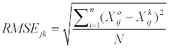
where  is the monthly precipitation or the monthly temperature for month j in year i (i = 1,2,…,N), and
  is the simulated precipitation or the simulated temperature in month j using model k. The total RMSE for month j from all of the models can be defined by

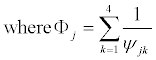
The weight for model k in month j is given by
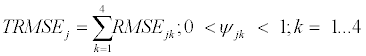
where larger weights indicate less accuracy in computing the historical temperature or precipitation. The temperature or precipitation ensemble for month j is
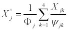
with Xjk is the precipitation or the temperature value found from model k.
Finally, the expression can be expressed as follows:
Results
Recent trends of precipitation and temperature
Currently, the average annual precipitation varies from as low as 1500 mm in the western region to as high as 5000 mm in the eastern region [26]. The average temperature of Bangladesh ranges from 17°C to 21°C during winter and 27°C to 31°C during summer. Specifically, following three distinct seasons can be recognized in Bangladesh from the climatic point-of-view: (i) The dry winter season from November to February, (ii) The pre-monsoon hot summer season from March to May, and (iii) The rainy monsoon and post-monsoon season from June to October, [26,27]. According to Agrawala [5], the general characteristics of the seasons are as follows:
• Winter is relatively drier, with the temperature ranging from a minimum of 7.2°C to 12.8°C to a maximum of 23.9°C to 31.1°C. This season virtually receives no precipitation.
• Pre-monsoon is the warmest with an average maximum of 37°C, very high rate of evaporation, and erratic but occasional heavy rainfall from March. In some places the temperature occasionally rises up to 40.6°C or more. The peak of the maximum temperatures is observed in April or May.
• Monsoon is both hot and humid, brings heavy torrential rainfall throughout the season. About four-fifths of the mean annual rainfall occurs during monsoon. Post-monsoon is a short-living season characterized by withdrawal of rainfall and gradual lowering of night-time minimum temperature.
• The mean annual rainfall is around 2000 mm, but there exists a wide spatial and temporal distribution.
Future precipitation pattern
Differences do exist in the projections made by different climate models. But the general findings are similar, that is, they are predicting more intense precipitation in Bangladesh in future years. That is to say, the predictions consistently indicate that the changes in the intensities of severe storms will be greater than the percentage change in average precipitation levels. In such case, variability is of more concern rather than average incident precipitation amount.
CGCM3.1 projections of total annual precipitation under different SRES scenarios are shown in Figure 1. The projections reveal very less variation between the trends under different scenario conditions. Slight increment in the average annual precipitation quantities are likely to occur under all scenarios, with prominent large fluctuations in successive years.
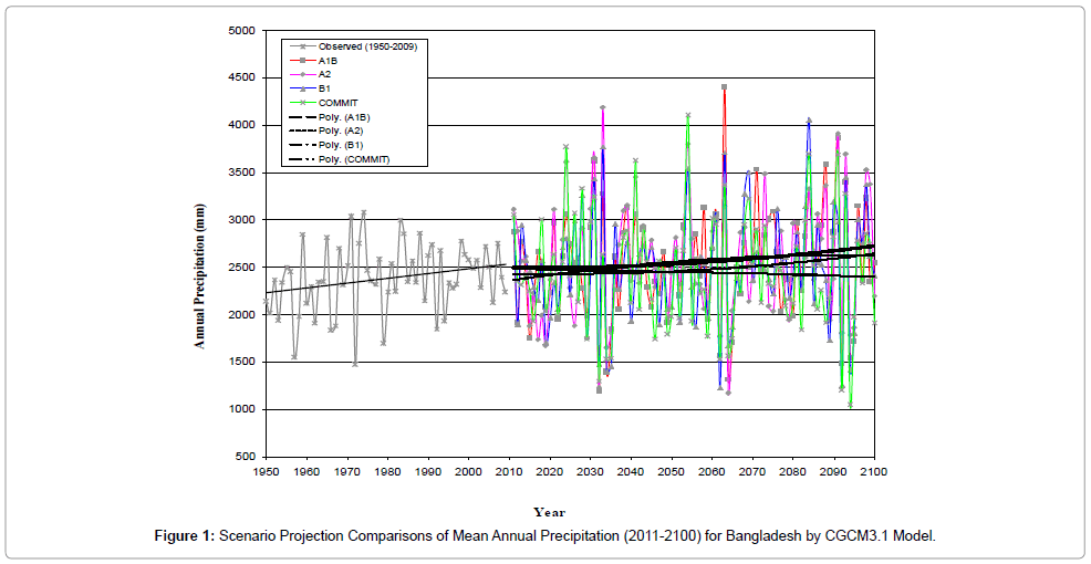
Figure 1: Scenario Projection Comparisons of Mean Annual Precipitation (2011-2100) for Bangladesh by CGCM3.1 Model.
Historically, January and July are the minimum and maximum precipitation months, representing dry and monsoon season respectively. Figures 2 and 3 represent monthly time series of applied change field GCM projections and ensemble mean with standard deviation ranges both for January and July respectively under A1B scenario. Although the calculations (not shown here) reveal dry season (November to February) precipitation likely to increase, virtually there will be almost little or no rainfall as it is in baseline period. Whereas, monsoon season (June to October) might experience a decrease in total incident precipitation by almost 25%. But most importantly, large scatters of MME precipitation as shown in Figure 3 demonstrate future years of more erratic rainfall events characterizing very high precipitation in one monsoon along with possible insignificant quantity in the monsoon of the very next year. Precipitation in a monsoon month can reach 1000 mm, constituting more than 50% of total annual precipitation amount in a year. Again it can lower to a level of 10 mm as well. These represent two extreme future scenarios with high concentric precipitation as well as exaggerated aridity situation respectively. Table 2 shows the ensemble mean monthly precipitation values with calculated standard deviation in three future time periods: 2011-2040, 2041-2070 and 2071-2100. Figure 4 features the extent of standard deviation averaged over three different segments of future time as discussed above. Standard deviation represents variability from mean condition. Ensemble mean precipitation in July is projected as 350 mm during the period 2011-2040 considering A1B scenario; where the 30 year period-averaged standard deviation is likely to be 120 mm and for most of the monsoon months, the calculated standard deviation is found to have amplified throughout the century. In rest of the months other than monsoon, standard deviation in three future time-segments remains almost the same.
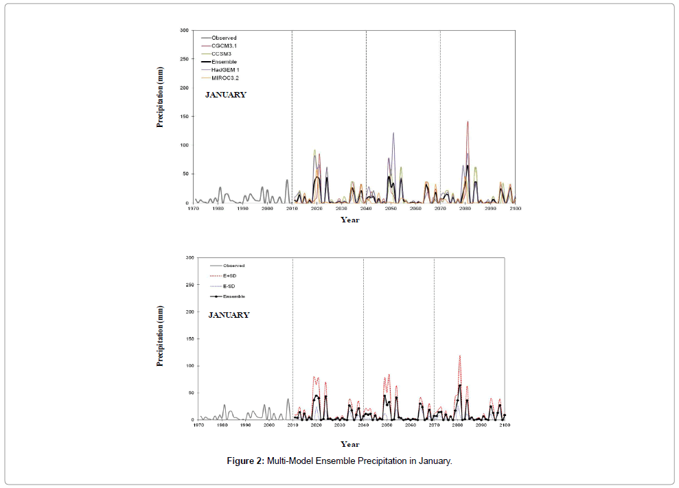
Figure 2: Multi-Model Ensemble Precipitation in January.
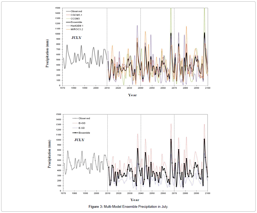
Figure 3: Multi-Model Ensemble Precipitation in July.
| Month | 2011-2040 | 2041-2070 | 2071-2100 |
|---|---|---|---|
| January | 10.2 ± 7.2 | 9.6 ± 7.1 | 10.2 ± 6.9 |
| February | 17.6 ± 10.7 | 17.8 ± 12.3 | 18.8 ± 11.8 |
| March | 22.8 ± 12.1 | 27.5 ± 12.6 | 27.8 ± 13.8 |
| April | 63.4 ± 37.0 | 63.9 ± 39.7 | 64.9 ± 36.7 |
| May | 148.6 ± 87.8 | 159.0 ± 85.6 | 172.1 ± 81.5 |
| June | 292.7 ± 129.2 | 296.8 ± 136.8 | 304.5 ± 143.6 |
| July | 340.3 ± 124.4 | 356.2 ± 131.3 | 399.8 ± 147.5 |
| August | 319.3 ± 125.5 | 308.6 ± 119.7 | 325.4 ± 128.8 |
| September | 339.9 ± 128.2 | 322.9 ± 136.5 | 327.4 ± 143.8 |
| October | 135.2 ± 58.02 | 126.9 ± 56.5 | 118.9 ± 51.4 |
| November | 20.3 ± 11.8 | 21.9 ± 13.0 | 20.8 ± 12.6 |
| December | 14.4 ± 6.9 | 15.8 ± 6.4 | 16.3 ± 5.5 |
Table 2: Multi-Model Ensemble Mean Precipitation (± Standard Deviation).
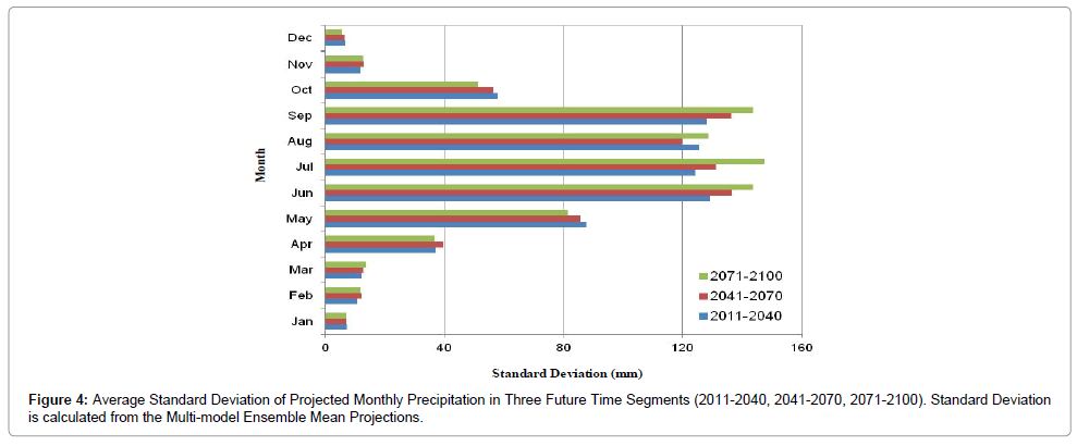
Figure 4: Average Standard Deviation of Projected Monthly Precipitation in Three Future Time Segments (2011-2040, 2041-2070, 2071-2100). Standard Deviation is calculated from the Multi-model Ensemble Mean Projections.
The annual cycle of precipitation in three time segments are shown in Figure 5, from which it is evident that HadGEM1 distinctly underestimates monsoon (June to October) precipitation after 2040 compared to the other models. HadGEM1 includes ‘Bulk Mass Flux’ in its process of precipitation parameterization and it neither uses explicit assumptions on the mass and thermodynamic budgets of cumulus clouds, nor provides information on the mass spectrum of various cloud types [28]. Therefore, HadGEM1 may not necessarily consider a realistic cloud distribution and this turns into lower precipitation projections in monsoon. On the other hand, MIROC3.2 overestimates monsoon precipitation relative to the other models. MIROC3.2 might have considered condensation of cloud with super-saturation of local relative humidity which has attributed to such difference in projections. In fact, the possible reasons behind dissimilarity in individual model projections lie mainly with the particular model-physics, typical assumptions, processes of parameterizations, etc. Therefore, a single model’s outputs are not of sufficient reliability which again justifies development of multi-model ensemble scenarios. In addition to the inter-model comparison, Figure 5 also shows the ensemble mean annual cycle of precipitation in three future time-segments (2011-2040, 2041-2070, 2071-2100) along with maximum and minimum ranges as projected by any of the models employed herein. Ensemble mean precipitation by the end of the century (during 2071-2100) is slightly higher and the histogram in Figure 6 is also reflective of that.
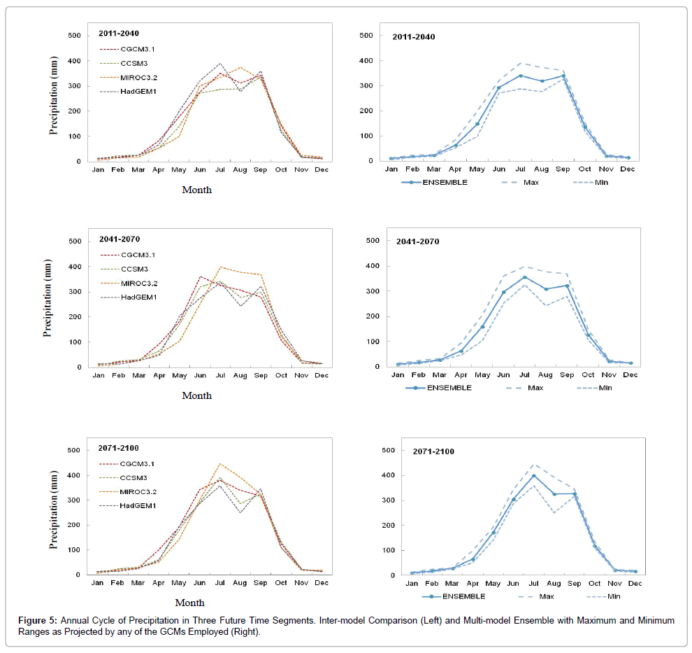
Figure 5: Annual Cycle of Precipitation in Three Future Time Segments. Inter-model Comparison (Left) and Multi-model Ensemble with Maximum and Minimum Ranges as Projected by any of the GCMs Employed (Right).
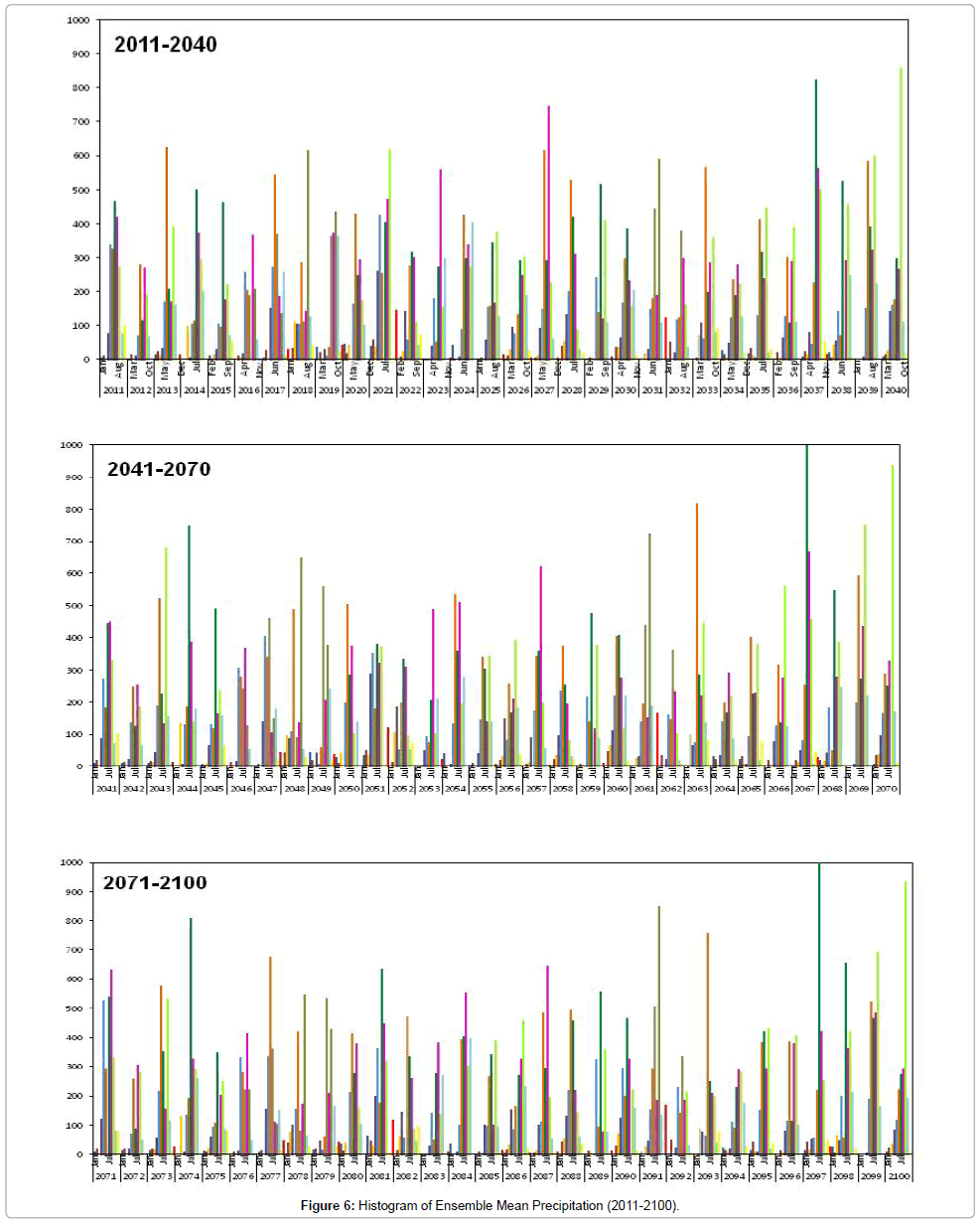
Figure 6: Histogram of Ensemble Mean Precipitation (2011-2100).
Vegetation is an important factor for soil conservation through its role in reducing the erosive impact of precipitation. A large number of studies concluded that the rate of soil erosion decreases as the vegetation cover increases. However, the amount of soil loss changes according to both the vegetation type and structure [29]. The study by Gessner [30] on the relationship between precipitation anomalies and satellite derived vegetation activity shows that vegetation development is sensitive to precipitation anomalies nearly over the 80% of the Central Asian land surface. The current study shows that intensive precipitation events are likely to occur in future in Bangladesh. Rainfall events occurring over longer time periods allow more moisture to enter the soil profile storage which ultimately helping the vegetation cover to grow accompanied by a reduction in the soil erosion. On the contrary, rainfall of greater magnitude occurring within a shorter time period, which is likely to be the case for Bangladesh in future, can translate into possibility of greater scour, erosion and flooding potential [16,31]. Since large fluctuations of precipitation quantities are possible in some of the future years in Bangladesh, there will be monsoon with very little rainfall as well. So there might be severe water shortage problems too, resulting aggravated drought condition and reduced crop yield.
Future temperature condition
In multiple scenario comparison of temperature projections by CGCM3.1 (Figure 7), the SRES A2 scenario exhibits increase at the highest rate of all the scenarios considered, reaching a mean annual temperature of 29.3°C for the period 2071-2100. For the same period, the A1B scenario projects the mean annual temperature to reach 28.5°C and the B1 scenario 27.7°C. With greenhouse gas emissions preset at year 2000 conditions, the COMMIT scenario projects the mean annual temperature to be 26.25°C for the period 2071-2100, a 0.15°C reduction from the 2041-2070 mean. Thus, the extent of temperature increase in Bangladesh as a result of climate change is found to have considerable sensitivity to the emission levels.
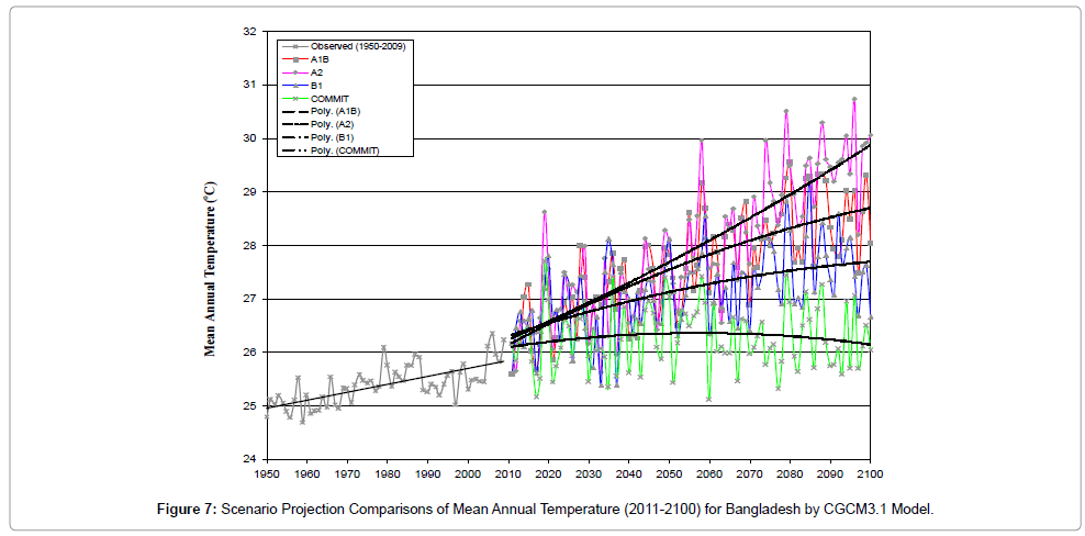
Figure 7: Scenario Projection Comparisons of Mean Annual Temperature (2011-2100) for Bangladesh by CGCM3.1 Model.
Monthly ensemble mean temperature projections under A1B scenario in three future time segments 2011-2040, 2041-2070 and 2071-2100 are shown in Figure 8. From there, it is evident that the mean temperature in pre-monsoon and monsoon is expected to cross 30°C after 2040; also temperature is likely to increase invariably in every month. Figure 9 and Figure 10 represent monthly time series of applied change field GCM projections and ensemble mean temperature with standard deviation ranges both for January and May respectively under A1B scenario. In both cases, temperature trends are increasing invariably through future time, matching fairly well with the observed patterns.
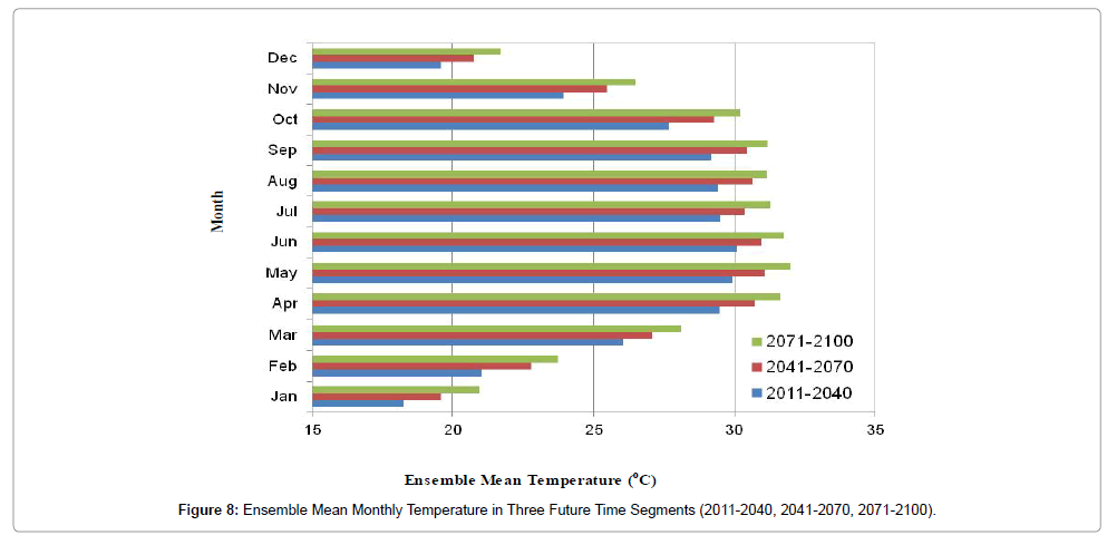
Figure 8: Ensemble Mean Monthly Temperature in Three Future Time Segments (2011-2040, 2041-2070, 2071-2100).
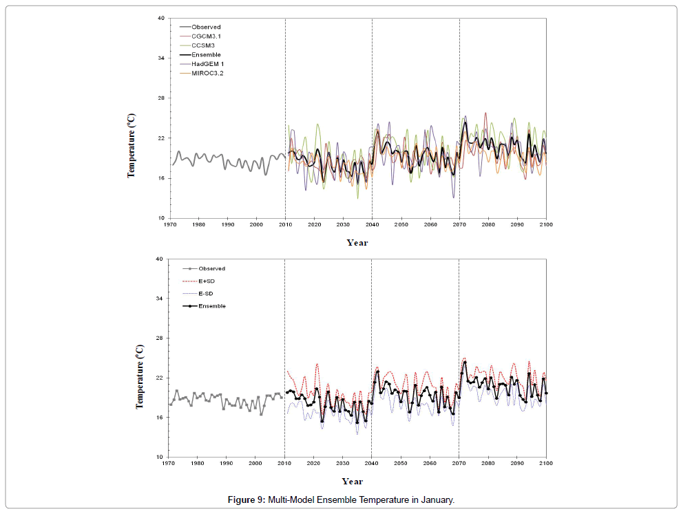
Figure 9: Multi-Model Ensemble Temperature in January.
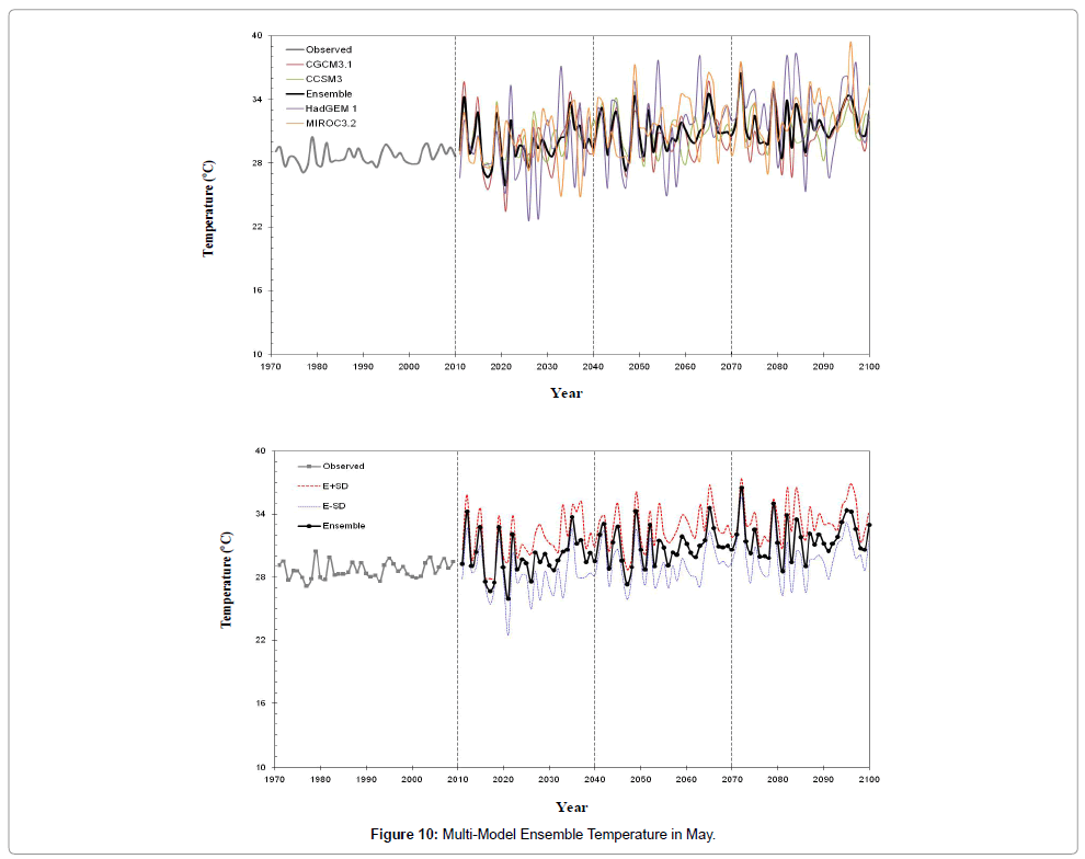
Figure 10: Multi-Model Ensemble Temperature in May.
The annual cycle of surface temperature in three time segments are shown in Figure 11, from which it is evident that HadGEM1 distinctly overestimates temperature after 2040 compared to the other models. Explanation for relatively high future temperature in Bangladesh as projected by HadGEM1 lies with the fact of HadGEM1 underestimating cloud formation as discussed in earlier section. Because the lower the amount of cloud cover simulated by the model, the more the response to solar heating. In addition to the inter-model comparison, Figure 11 also shows the ensemble mean annual cycle of temperature in three future time-segments along with maximum and minimum ranges as projected by any of the models being employed. This also exemplifies the consistent increasing trend of surface temperature in Bangladesh throughout future times. Finally, Table 3 brings together the ensemble mean monthly temperature values with calculated standard deviation in three future time periods: 2011-2040, 2041-2070 and 2071-2100. Apparently the possible standard deviation in pre-monsoon months (March to May), which constitute the historically warmest months, has been found around 1.7°C-1.9°C which is pretty high relative to most other months. This is the evidence of the pre-monsoon months to exhibit extreme heat waves in the future.
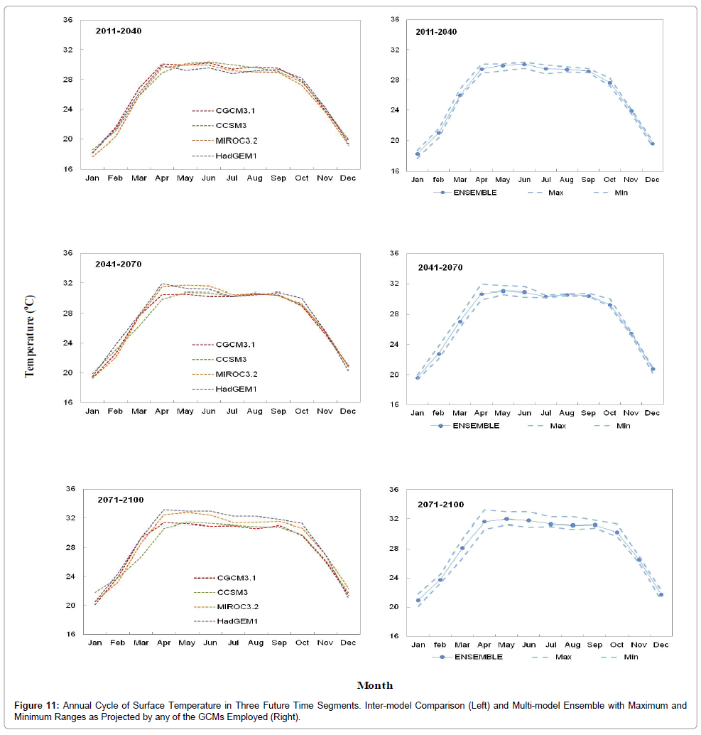
Figure 11: Annual Cycle of Surface Temperature in Three Future Time Segments. Inter-model Comparison (Left) and Multi-model Ensemble with Maximum and Minimum Ranges as Projected by any of the GCMs Employed (Right).
| Month | 2011-2040 | 2041-2070 | 2071-2100 |
|---|---|---|---|
| January | 18.3 ± 1.5 | 19.6 ± 1.4 | 21.0 ± 1.4 |
| February | 21.0 ± 1.5 | 22.8 ± 1.6 | 23.8 ± 1.7 |
| March | 26.0 ± 1.7 | 27.1 ± 1.8 | 28.1 ± 1.9 |
| April | 29.5 ± 1.7 | 30.7 ± 1.8 | 31.6 ± 2.1 |
| May | 30.0 ± 1.8 | 31.1 ± 1.8 | 32.0 ± 1.8 |
| June | 30.1 ± 1.5 | 30.9 ± 1.5 | 31.7 ± 1.9 |
| July | 29.50 ± 1.6 | 30.3 ± 1.4 | 31.3 ± 1.5 |
| August | 29.4 ± 0.9 | 30.6 ± 1.0 | 31.2 ± 1.3 |
| September | 29.2 ± 1.1 | 30.5 ± 1.1 | 31.2 ± 1.2 |
| October | 27.7 ± 1.4 | 29.3 ± 1.4 | 30.2 ± 1.4 |
| November | 24.0 ± 1.4 | 25.5 ± 1.4 | 26.5 ± 1.4 |
| December | 19.6 ± 1.2 | 20.8 ± 1.3 | 21.8 ± 1.4 |
Table 3: Multi-Model Ensemble Mean Temperature (± Standard Deviation).
The risks arising from projected human induced climate change increase significantly with increasing temperature. Below a 1°C increase, the level of risk is low but in some case not insignificant particularly for highly vulnerable ecosystems. In the 1°C-2°C increase range risk factor increase significantly and at a regional level are often substantial. Above 2°C the risks increase very substantially involving potentially large extinctions or even ecosystem collapses, major increases in hunger and water shortages as well as socio-economic damages, particularly in developing countries.
Conclusion
From the prediction of multi model ensemble mean with respect to the climatologic baseline 1971-2000 for Bangladesh, following conclusions can be drawn:
• The Precipitation projections by CGCM3.1 reveal very less variation between the trends under different scenario conditions.
• Monsoon season (June to October) might experience a decrease in total incident precipitation by almost 25%. But most importantly, large scatters of multi-model ensemble precipitation are prominent which demonstrate future years of more erratic rainfall events characterizing very intensive precipitation in one monsoon along with possible insignificant quantity in the monsoon of the very next year. However, the total annual precipitation may remain almost the same as the baseline years with the chances of being slightly higher by the end of this century.
• The 30 year period-averaged standard deviation of precipitation in a monsoon month (e.g. July) may go around 120 mm, which signifies ‘variability’ to be of more concern rather than average precipitation amount the country will get. However, there will be spatial disparity of such pattern in different zones of Bangladesh, which has not been assessed in this study.
• By developing the projections of a particular climate model (CGCM3.1) under different emission scenarios, the extent of increase of temperature in Bangladesh is found to be highly sensitive to the extent of emissions to the atmosphere. The SRES A2 scenario exhibits increase at the highest rate of all the scenarios considered, reaching a mean annual temperature close to 30°C by the year 2100.
• Mean temperature is likely to increase invariably in every month; especially the temperature in pre-monsoon and monsoon is expected to cross 30°C after 2040. The possible standard deviation in pre-monsoon months (March to May) has been found around 1.7°C - 1.9°C which is pretty high relative to most other months. This is the evidence of the premonsoon months to exhibit extreme heat waves in the future.
• Compared to the other models, HadGEM1 distinctly overestimates temperature and underestimates monsoon (June to October) precipitation after 2040. In-depth analysis of possible reasoning behind this is kept out of scope for the present research.
Since the inherent physics and associated parameterization of the atmospheric, ocean, sea-ice and land-surface components is different for different climate models, it is always better to analyze the combined aspect of several models; which therefore gives way to a rational prediction of future climatic conditions. Application of regional climate models other than GCMs can provide better regional details in this regard. Still, the attempt and associated results of country-scale multi-model ensembling from this study can be utilized by stakeholders and policy makers in multipurpose uses including water resources management, agricultural planning and so on.
Acknowledgement
This research has been conducted under the auspices of the British Council Funded Higher Education Link Programme (BC-HELP) in Bangladesh University of Engineering and Technology (BUET). Authors gratefully acknowledge Professor Edward A. McBean, Canada Research Chair on Water Supply Security, for providing the GCM simulation data.
References
- Rajib MA, Rahman MM (2012) A comprehensive modeling study on RCM application- regional warming projections in monthly resolution under IPCC A1B scenario. Atmosphere 3: 557-572.
- BUP-CEARS-CRU (1994) Bangladesh: Greenhouse Effect and Climate Change. Briefing Documents 1-7, Bangladesh Unnayan Parishad (BUP), Centre for environmental and Resource Studies (CEARS), University of Waikato, New Zealand and Climate Research Unit (CRU), University of East Anglia, Norwich, UK.
- Mirza MM (1997) Modeling the Effects of Climate Change on Flooding in Bangladesh. D.Phil. Thesis, International Global Change Institute (IGCI), University of Waikato, Hamilton, New Zealand.
- World Bank (2000) Bangladesh: Climate Change and Sustainable Development. Report No. 21104-BD, Rural Development Unit, South Asia Region, The World Bank (WB), Dhaka, Bangladesh.
- Agrawala S, Ota T, Ahmed AU, Smith J, van Aalst M (2003) Development and Climate Change in Bangladesh: Focus on Coastal Flooding and the Sunderbans. Organization for Economic Co-operation and Development (OECD), Paris, France.
- Ramamasy S, Baas S (2007) Climate Variability and Change: Adaptation To Drought In Bangladesh. Prepared under the Asian Disaster Preparedness Centre and Food and Agriculture Organization of the United Nations. Rome, Italy.
- Tanner TM, Hassan A, Islam KM, Conway D, Mechler R, et al. (2007) ORCHID: Piloting Climate Risk Screening in DFID Bangladesh. Institute of Development Studies, University of Sussex, UK.
- Jones RG, Noguer M, Hassell DC, Hudson D, Wilson SS, et al. (2004) Generating High Resolution Climate Change Scenarios Using PRECIS. Met Office Hadley Centre, Exeter, UK
- Nakicenovic N (2000) Greenhouse Gas Emissions Scenarios. Technol Forecast Soc Change 65: 149-166.
- IPCC-TGICA (2007) General Guidelines on the Use of Scenario Data for Climate Impact and Adaptation Assessment, Version 2. Intergovernmental Panel and Climate Change, Task Group on Data and Scenario Support for Impact and Climate Analysis, Cambridge University Press, Cambridge, UK.
- Raupach MR, Marland G, Ciais P, Le Quéré C, Canadell JG, et al. (2007) Global and regional drivers of accelerating CO2 emissions. Proc Natl Acad Sci U S A 104: 10288-10293.
- Ganguly AR, Steinhaeuser K, Kao SC, Parish ES, Branstetter M, et al. (2010) Trends and geographical variability in hydro-meteorological extremes for the 21st century from a climate model. Proceedings of the 3rd International Perspective on Current and Future State of Water Resources and the Environment, EWRI of American Society of Civil Engineers (ASCE) and IIT Madras, India.
- Rajib MA, Rahman MM, McBean EA (2011) Global warming in Bangladesh perspective: temperature projections upto 2100. Proceedings of the Global Conference on Global Warming, Lisbon, Portugal.
- Islam MN, Rafiuddin M, Ahmed AU, Kolli RK (2008) Calibration of PRECIS in employing future scenarios in Bangladesh. Int J Climatol 28: 617–628.
- CCSP (2008) Climate Models: An Assessment of Strengths and Limitations. A Report by the U.S. Climate Change Science Program and the Subcommittee on Global Change Research. Department of Energy, Office of Biological and Environmental Research, Washington DC, USA.
- Rajib MA, Rahman MM, McBean EA (2012) Evaluating technological resilience of small drinking water systems under the projected changes of climate. J Water Clim Change 3: 110-124.
- Booty WG, Lam DC, Bowen GS, Resler O, Leon L (2005) Modeling changes in stream water quality due to climate change in a Southern Ontario watershed. Can Water Res J 30: 211-226.
- Diaz-Nieto J, Wilby RL (2005) A comparison of statistical downscaling and climate change factor methods: impacts on low flows in the River Thames, United Kingdom. Clim Change 69: 245-268.
- Zhang XC (2005) Spatial downscaling of global climate model output for site-specific assessment of crop production and soil erosion. Agri For Meteorol 135: 215-229.
- Palmer TN, Doblas-Reyes FJ, Hagedorn R, Weisheimer A (2005) Probabilistic prediction of climate using multi-model ensemble: from basics to applications. Philos Trans R Soc Lond B Biol Sci 360: 1991–1998.
- Krishnamurti TN, Kishtawal CM, LaRow TE, Bachiochi DR, Zhang Z, et al. (1999) Improved Weather and Seasonal Climate Forecasts from Multimodel Superensemble. Science 285: 1548-1550.
- Kug JS, Kang IS, Choi DH (2008) Seasonal climate predictability with tier-one and tier-tow prediction systems. Clim Dyn 31: 403-416.
- Roy BS, Durai VR (2008) Multi-model ensemble forecasting of rainfall over Indian monsoon region. Atmosfera 21: 225-239.
- Mitra AK, Iyengar GR, Durai VR, Sanjay J, Krishnamurti TN, et al. (2011) Experimental Real-Time Multi-Model Ensemble (MME) Prediction of Rainfall During Monsoon 2008: Large-Scale Medium-Range Aspects. J Earth Sys Sci 120: 27-52.
- Ingol-Blanco EM, McKinney DC (2011) Modeling Climate Change Impacts on Hydrology and Water Resources: Case Study Rio Conchos Basin. Center for Research in Water Resources report, Bureau of Engineering Research, The University of Texas at Austin, USA.
- Shahid S, Behrawan H (2008) Drought risk assessment in the western part of Bangladesh. Nat Haz 46: 391-413.
- Rajib MA, Rahman MM, Islam AK, McBean EA (2011) Analyzing the future state of monthly precipitation pattern in Bangladesh from multi-model projections using both GCM and RCM. Proceedings of the ASCE World Environmental & Water Resources Congress, California, USA.
- Dai A (2006) Precipitation characteristics in eighteen coupled climate models. J Clim 18: 229-233.
- Zhongming W, Lees BG, Feng J, Wanning L, Haijing S (2011) Stratified vegetation cover index: A new way to assess vegetation impact on soil erosion. CATENA 83: 87-93.
- Gessner U, Naeimi V, Klein I, Kuenzer C, Klein D, et al. (2013) The relationship between precipitation anomalies and satellite-derived vegetation activity in Central Asia. Global Planet Change 110: 74-87.
- Trenberth KE (2011) Changes in precipitation with climate change. Clim Res 47: 123-138.
Citation: Rajib MA, Sultana S, Saha M, Rahman MM (2014) A Multi- Model Ensembling Approach for Developing Plausible Country-scale Climate Change Scenarios for Future. J Earth Sci Clim Change 5: 179. DOI: 10.4172/2157-7617.1000179
Copyright: ©2014 Rajib MA, et al. This is an open-access article distributed under the terms of the Creative Commons Attribution License, which permits unrestricted use, distribution, and reproduction in any medium, provided the original author and source are credited.
Select your language of interest to view the total content in your interested language
Share This Article
Recommended Journals
Open Access Journals
Article Tools
Article Usage
- Total views: 15791
- [From(publication date): 2-2014 - Jul 15, 2025]
- Breakdown by view type
- HTML page views: 11129
- PDF downloads: 4662