Modelling the Climatic Variability in the Niger Delta Region: Influence of Climate Change on Hydrology
Received: 17-Jun-2015 / Accepted Date: 16-Jul-2015 / Published Date: 26-Jul-2015 DOI: 10.4172/2157-7617.1000284
Abstract
With substantial variations to flood occurrence predicted as a result of climate change it becomes significant to investigate how global hydrological models process climate-forcing data. The paper presents reasonable analyses of projected hydrological effects of climate change on the Niger Delta region, Nigeria. Runoff simulated represent the present and future flood risk for the catchment of the River Niger using Global Hydrological Models (GHMs) from EU WATCH project driven by three GCMs. The simulated discharges are compared with the monthly gauge measurement along the River Niger from the Global Runoff Data Centre (GRDC). A period of (1970-2050) was chosen to understand the climatic variability across the Niger Delta region. The GHMs under Special Report on Emissions Scenarios A2 scenario were used to provide future climate scenarios over the Niger River. The hydrological models from EU WATCH project were used to calculate flood extents for different model outputs. The simulation shows clears trends of increased in river discharge over the catchment although uncertainty cannot be over role. Considering the future climate suggests that river flow from the basin could be substantially increased, especially in the long term when compare to the reference period. It is not applicable to formulate precise recommendations for management of runoff in the Niger Delta region as Todd highlighted that the degree of uncertainty in future projections of river flow is consider as a constrained towards developing applicable adaptation activities. The rationale behind this work is the need to understand in clear terms the climate change threats on the Niger Delta region; this will form a practical basis for developing adaptation strategies to manage future climate risks.
Keywords: Climatic variability; Hydrology; Runoff; Rainfall; Quantification; Venerability; Adaptation; Flooding; Uncertainty; Climate change
11547Introduction
Currently, it is clear that the Earth’s climate is changing [1,2]. Scholars are interested to study the established interactions between climate and the problems associated with them (National Academies Press (US); 2008). The changes is now contributing to human and environmental hazards experienced in the whole world, leading to poverty, hunger and malnutrition especially in Africa whose adaptive capacity is low [2]. It is evident that global warming is fast-tracking the global hydrological rotation, increasing the concentration, occurrence, and extent of droughts; heavy precipitation events; and flooding [3]. Also, it is reported by Zewdie [4] that Sub Saharan Africa might likely be the most affected regions to climate change this is because most of the population is reliant on climate sensitive economic activities. Furthermore, it is projected that the coastal communities will be more vulnerable to the effects of climate change, leading to increase in frequency and intensity of flood. Because increased precipitation would intensify the exposure of coastal regions to natural hazards [5,6].
This is particular of the Niger Delta region of Nigeria. Recently,over the years this region of Nigeria has experienced perennial flooding Ologunorisa [7,8] which comes from the high precipitation and runoff from rivers. These changes are exceedingly disturbing because the ecosystem is under threat from climate variability and change and other stresses IPCC Ar4 report on impacts, adaption and vulnerability [9]. The wetlands are important to the local communities and provide a variety of ecosystems vital to human well-being [9-11]. The exposure of the delta to the impacts of climate change is a serious concern [9]. Since 70% of its population and infrastructure are situated in low-lying coastal areas. This would threaten the livelihood and development options of the Niger Delta and the country. It is important according to Hamid et al. [12] to carry out investigation of hydro-meteorological data for a detailed evaluation of climate change effects and climate unpredictability on the water resources.
Climate prediction is progressively gaining recognition because of its significance in impacts assessment of climate change. Responding to climate change adaptation should be based on the use of reliable climate information, through policy intervention to plan for climate risk. Global Climate Models (GCMs) has been recognized to simulate dependably the most significant mean feature of global climate at the planetary scales. But the spatial gauges at which GCMs can operate is 3.75° longitude × 3.75° latitude and is very coarse when compared to that of a hydrologic process [13]. This is of great concern in climate change impact assessment studies. Thus Global Hydrological Models (GHMs) have been recognized for water resources valuation, especially for studying the impact of climate change. Wieland et al. [14] pointed out that GHMs give better representation of the hydrological processes. It is, consequently, of importance to quantify river discharges from rainfall values in other to understand the projected changes for better management of water resources in the future. Uncertainty in the quantification of future climate change presents a crucial challenge for adaptation planning [15]. This is as a result of anthropogenic emissions, large-scale and regional scale changes that are sensitive to the climate model parameterizations and internal dynamics [4]. Therefore Chen et al. [16] suggest that it is important to use more than one GHM for climate change impacts assessment in the future.
This paper highlights the high vulnerability of Niger Delta to climate change as a result of low adaptive capacity constrained by several factors at the national level. The floods of September 2012 in Nigeria highlight huge differences in adaptive capacities of Nigeria. According to Allali et al. [17] adaptive capacity was swayed mainly by the ability to communicate possible risks to vulnerable communities and the ability to respond as a result of perceived risks. The purpose of this paper is the quantification of climate risk profile from River Niger discharges from rainfall values using hydrological model from EU Watch project simulation based on the SRES A2 scenario.
Study Area
Nigeria is located in western Africa, the Federal Republic of Nigeria between Latitudes 4° to 14° North and between Longitudes 2° 2´ and 14° 30´ East [18].
Nigeria coastline is about 850 km, divided into four main units: Strand coast, Mud coast, Barrier Lagoon coast and the Niger Delta [19]. The mineral resources such as oil and gas from this region contribute to economy development of the country particularly the Niger Delta. The paper will focus on the Niger Delta coast.
The Niger Delta lies in southern part of Nigeria where the River Niger divides into numerous tributaries. It extends between 5.05° E and 7.35° E longitude and 4.15° N and 6.01° N latitude [20]. Around 2,370 square kilometers of the area consist of rivers, creeks and estuaries, while about 8600 square kilometers covers the stagnant swamp. The ecosystem are highly supportive and diverse various species of terrestrial and aquatic flora and fauna and human life [21]. The region cut across nine state which include Abia, Akwa Ibon, Bayelsa, Cross River, Delta, Edo, Imo, Ondo and Rivers (Figure 1).
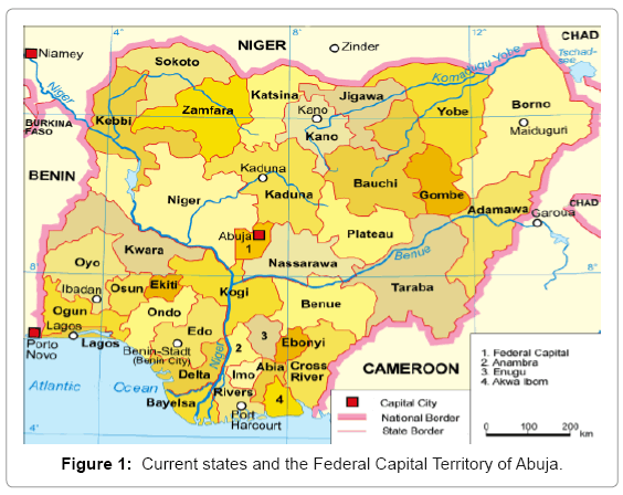
Figure 1: Current states and the Federal Capital Territory of Abuja.
The Delta is of great strategic importance to communities and to the world, but it is compromised for a number of developmental and environmental challenges as reported by Booz Allen Hamilton [22]. The wetlands provide food, water and livelihood security for the poor people living around the delta area. Coastal regions are vulnerable to extreme events, such as storms, which impose significant costs on coastal area (IPCC reported in Nicholls et al. [23] meaning that the Niger Delta lowland shall be exposed to higher risks of flooding. Oil exploration in the region has brought environmental degradation of enormous dimensions Nigerian Environmental Study/Action Team [24]. Particularly consistent gas flaring, which has taken place in this region since the commencement of oil exploration, is enough to contribute to increase the atmospheric temperature. IPCC predicted that the coastal region is likely to be inundated as the temperature increases, the sea level will rise. Currently the delta is faced with range of environmental problems, including: flooding, population pressure, soil and coastal erosion and oil pollution [25]. The exposure of the delta to the impacts of climate change and sea-level rise is serious concern because 70% of its population and infrastructure are situated in lowlying coastal areas. This portends a threat to lives and livelihood in the Niger Delta region (Figure 2).
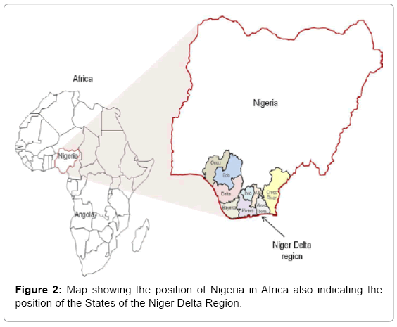
Figure 2: Map showing the position of Nigeria in Africa also indicating the position of the States of the Niger Delta Region.
The study concentrates on River Niger basin discharge at the entry to Niger Delta. River Niger is located in West Africa starts in the highlands of Guinea the river flows northeast into Mali and Niger then enter Nigeria and flows mainly southwards, finally entering the Atlantic Ocean through a series of distributaries (Figure 3) [26].
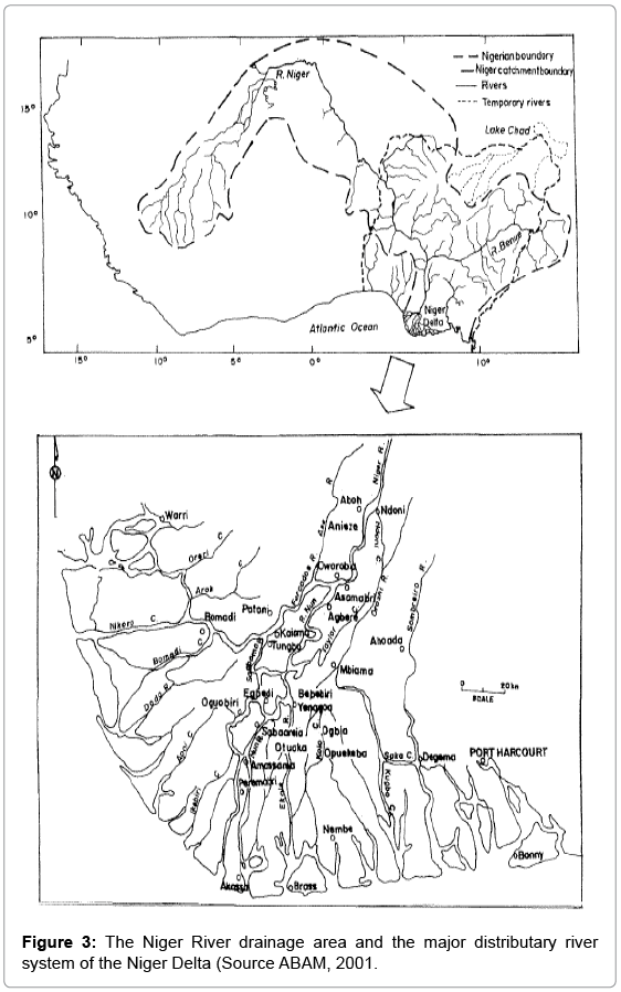
Figure 3: The Niger River drainage area and the major distributary river system of the Niger Delta (Source ABAM, 2001.
Data and Method
In this paper, the simulation within the Niger Delta basin was carried-out on River Niger basins at the entering into the Niger Delta based on the quality and quantity of available data and the need to attain a hydrological modeling system at basin scale. The study used the hydrological models from EU WATCH project to calculate flood extents and depths for different model outputs. For better understanding of the global water cycle for the past, present and future EU- funded WATCH (Water and Global Change) project. The emphasis is to estimate the likelihood of an urgent need to improve flood preparedness through procedures that reduce vulnerability and risk [27]. GHMs are appropriate to analyse the effects of changes in climate and land use on average, low and peak discharges in the subcatchments [28]. Weiland et al. [14] highlights that GHMs have better given representation of the hydrological processes.
GHMs are driven by three GCMs (CNRM, ECHAM5 and IPSL) and a total of two climate scenarios B1, A2 and a Control. The GHMs used for this study are H08, WaterGap, LPJmI, Jules and MPI-HM. These models were chosen because they were able to reproduce in a reasonable manner the observed annual and seasonal cycle in river Figure 1: Current states and the Federal Capital Territory of Abuja. discharge over the study area. The five GHMs used are driven by three GCM except Jules that is driven by two CNRM and ECHAM5. The analyses were run with A2 the worst-case emission scenario. This is because the increase numbers of people and properties at risk at the coast are exposed to further stresses due to land use and hydrological changes in catchments [9]. The five GHMs were run for the period of 1958-2050. The daily data was combining into monthly time steps in the 20th Century runs (Figure 4).
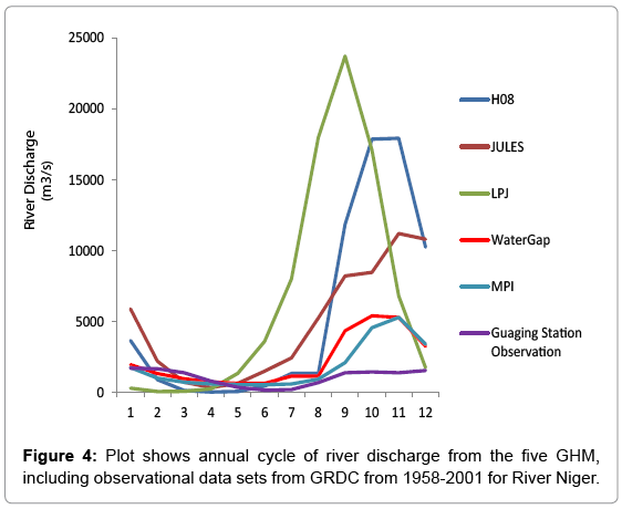
Figure 4: Plot shows annual cycle of river discharge from the five GHM, including observational data sets from GRDC from 1958-2001 for River Niger.
Understanding of the atmospheric controls and climate impact of precipitation in African is still uncertain [29,30]. This is because rainfall exhibits prominent spatial and temporal inconsistency. For better understanding of the dynamics of these processes and the identification of the models better sources is partly accomplished using observation. Over the evaluation period (1958-2050) in this study, the simulated discharges from WATCH models are compared with the monthly gauge measurement along the River Niger from the Global Runoff Data Centre (GRDC).
Analyses
The simulations were based on the SRES-A2 over the reference period (1958-2001) for GHMs and for the 21stC (2020-2050). The analyses were based on output provided by discharge calculations as provided by EU WATCH project hydrological models. The data were analyzed using Microsoft Excel, KNMI Climate Explorer Exceed onDemand, and Climate Data Operators (CDO) software. To visualize the climate data the results were shown in Linux based software, including the Grid Analysis and Display System (GrADS. The analyses started by extracting the Niger Delta region for the study period.
To quantify the climate risk profile for delta flooding due to changes in the flow characteristics of the River Niger at the entry point to the Niger Delta. The study analysed the data from the outputs of five GHMs from EU WATCH project to calculate the annual cycle of River Niger flow. This is to determine distribution of River Niger discharge at the entry to the Niger Delta for the 20th Century (Figure 5), control period and 21st Centure, and was compared with the observational data sets from GRDC to determine the correlation between the model and observation. Impact assessment of climate risks is intended to identify the hazards caused by or exacerbated by climate change and to evaluate their effects. Past extreme events may be used as indicators of future trends, and can be invaluable in evaluating how climate change has affected River Niger discharges in the Niger Delta region. Differences in mean annual cycle and percentage change in mean seasonal cycle was calculated in order to understand the projected changes to discharges in the 21st Centure in Niger Delta region. This is to examine the projected changes between the control period and the 21st Centure for 31 year in the reference period for River Niger discharges. Assessment of the impact of climate change, despite having been the subject of intensive study in recent years, is still very unclear. Only the ranges of possible values usually describe uncertainties in projections of different climate variables. The study will identify the existing uncertainty associated with the quantification of climate risk.
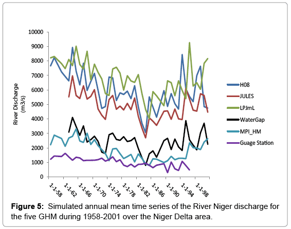
Figure 5: Simulated annual mean time series of the River Niger discharge for the five GHM during 1958-2001 over the Niger Delta area.
Results
River discharge simulations from the 20th Century
Niger River runoff simulation of Global Hydrological Model (GHM) and observed discharges from the 20th Century run represented in Figure 3 indicates that the river has experienced alternating high and low runoff occurrences on annual cycle during the 43 years of record. The sensitivity of the river discharge to the changing climate has important consequences on the climate models to simulate appropriately the current mean state of the River Niger as reflected by [31]. The simulated discharges reproduce differently from observation, although the majority of the GHMs overestimated the river discharge. The dissimilarity between the simulations and observations can be ascribed to numerous errors such as those in the meteorological forcing, discharge records and model constraints. It is worth noting that the magnitudes of the projected changes differ among the GHM. The differences between the models are major source of uncertainty as Haddeland et al. [32]; Chen et al. [16] noted in their study.
The study over this place observed that the annual cycle of River Niger discharge was overestimated by LPJmL with magnitude value of 23742 m3/s, followed by H08 with the magnitude value of 17933 m3/s, JULES also overestimated the river discharge with magnitude value of 11204 m3/s. WaterGap and MPI_HM are relatively closer to the observational record. Although the observational data sets do not guarantee that the spatiotemporal distribution of River Niger flow is well represented. According to the results displayed WaterGap and MPI_HM has reproduced the River Niger discharge better than the other three GHMs for the 20th Century run in this study. The likely changes in River Niger discharge under A2 scenario are anticipated to intensify floods risks in the Niger Delta region. This is in accordance with IPCC report on African coasts [2].
Annual monthly time series from 20th Century
The simulated time series depicts the annual pattern distribution and the yearly variability of River Niger discharge from 1958-2001 over the delta. The GHMs represented differently from observation and with large inconsistency among the GHM. It might be because of the uncertainty associated with GHMs when simulating runoff. Figure 5 showed that runoff dramatically decreased in the period during the late 1970s to the early 1980s which is as a result of less rainfall during this period which coincides with a great drought of West African Sahel region as Descroix et al. [33] noticed in their study. Again, Babatolu et al. [34] observed in their study that runoff variability over River Niger area noticed increased flow during 1955-70 periods and decreased during 1970 to the lowest flow in the 80s and increased again from about 90s such that was noticed in this study. However, the study notices that LPJ mL has the highest magnitude value of 9266.2 m3/s of the river discharge across the GHMs. The lowest magnitude value of 2399.2 m3/s is from MPI_HM.
21st Centureentury simulation of river discharge
Figure 6 shows the annual cycle of river discharge from the five GHM driven by three GCMs for the 21st Centure runs. The ability to forestall the projected scenario over River Niger discharge at the entry to the Niger Delta region is of essential importance in regards to adaptation strategies for local societies [35]. The results show noticeable evidence of climatic variability and change in the River Niger basin. The results represented differently in terms of magnitude among the GHMs driven by GCMs but the distribution of the annual cycle was notice from all the GCMs. The outcomes show an increase in River Niger discharge from 2020-50 from the majority of the GHMs. while some indicate a decrease. For instance, H08 has an increase value of 21450 m3/s by 2020-50. Same with MPI_HM has an increase value of 8848.9 (m3/s) by 2020-50. The inability of climate models to response to river discharge has a significant impact on the mean flow due to occurrence of very dry conditions in the winter period. Further results project an increase in river discharge across all the GCMs for the 30 years periods over the entire basin. The increase demonstrates the resilient changes in the frequency of floods as IPCC Ar4 Boko et al. [9] predicted.
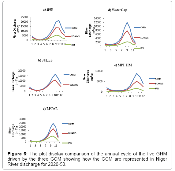
Figure 6: The plot display comparison of the annual cycle of the five GHM driven by the three GCM showing how the GCM are represented in Niger River discharge for 2020-50.
The projected difference between the 21st Century and the control
Figure 7 present the changes of the 21st Centureentury runs from the period of 2020-2050 and baselines 1971-2000 mean annual cycle. The results indicate changes although the magnitudes of the change differ between the GHMs. The difference can be attributed to numerous errors such as model constraints, or simplifying assumptions. The study noted that the GHM distribution of the river discharge is remarkably alike. This similarity indicates that the GHM are in agreement with the annual cycle of River Niger flow with the peak discharge from September/October. This signified that this study succeeded in extracting the River Niger region for the purpose of the study. However the simulated changes are relatively high in CNRM and ECHAM5 while IPSL shows a decreasing trend throughout the GHM. The changes are dependent on the assumptions in the estimates of projected scenario by IPCC over the coastal region Boko et al. [9] given a large uncertain band and spanned by climate models. Changes among the GCM in the 30 years period are noticeable. For instance CNRM runs appear more regular in all the models for the 30 years periods with a higher magnitude. ECHAM appear to be irregular in distribution of the river discharge for the simulation. While IPSL runs seem to be more unpredictable, but indicate a decreasing trend during the period. It is worth noted that CNRM LPJmL has the highest magnitude value of 6663.3 m3/s for 2020-50. Whereas the study observe that MPI_HM has the smallest magnitude value of river discharge.
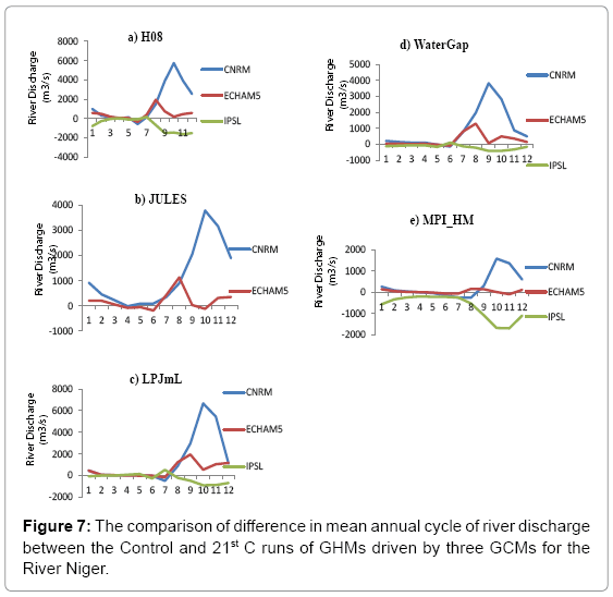
Figure 7: The comparison of difference in mean annual cycle of river discharge between the Control and 21st C runs of GHMs driven by three GCMs for the River Niger.
Percentage change in mean seasonal river flow
The study calculated percentage change in mean seasonal flow. The seasons presented are based on the month of July, August, September, October, November and December. These months are usually the period of heavy flow in the Niger Delta. Presently, it is expected that an increase in seasonal rainfall will increase the magnitude of peak flows during these seasons in the Delta. This change in seasonality will also lead to an overall increase in the magnitude of the mean annual flood in this region. The percentage changes were calculated between the baseline and 21st Centure runs for the River Niger discharge. Figure 8 illustrates the results of the percentage change in mean seasonal flow between the control periods and the 21st Centure runs. The study noticed changes from the GHMs although the magnitude of these changes varied between the GCMs. CNRM shows a massive increase in river discharge during the periods while ECHAM5 shows a reasonable increase. The results from IPSL projected a decrease in runoff for the simulation period. Overall an increase is projected from CNRM and moderate increase is projected from ECHAM5 for the River Niger flows during simulation period.
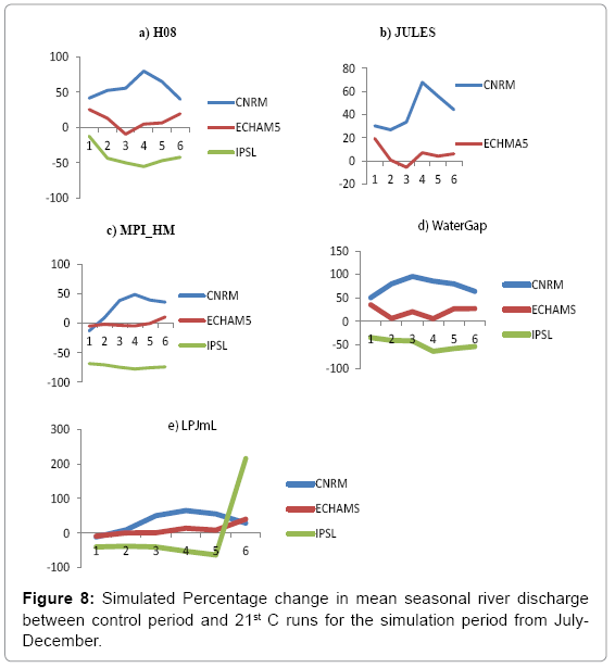
Figure 8: Simulated Percentage change in mean seasonal river discharge between control period and 21st C runs for the simulation period from July- December.
Table 1 summarises the percentage change in mean seasonal discharge between the GHMs which indicates that the River Niger discharge has experienced alternating high and low runoff episodes on seasonal discharge during the 31 years of record. The observed increase and decrease in runoff of this period is likely due to human-induced climate change, uncertainty cannot not be over role. A Change in percentage of river discharge shows that H08 CNRM is considerably greater than the maxima simulated by the other GHMs with 23.033% change over the simulation period.
| GHM | 2020-2050 | ||
|---|---|---|---|
| GCM | |||
| CNRM | ECHAM5 | IPSL | |
| H08 | 23.03283 | 3.149161 | -31.3021 |
| JULES | 18.54947 | 1.703844 | |
| LPJmL | -99.74 | -99.92 | -100.04 |
| WaterGap | -98.34 | -99.42 | -108.12 |
| MPI_HM | 15.87425 | 0.133759 | -59.9894 |
Table 1: The summary of percentage change in mean seasonal discharge between the baseline 1971-2001 in control runs and the period in the 21st C runs.
Discussion
Hydrological effects of climate change on the Niger delta
The study quantify the hydrological effects of climate change for River Niger at the entry to the Niger Delta for the baseline and 21st Centure runs using five GHMs driven by three GCMs. The study noted an increase in River Niger discharge across the Niger Delta region. This suggests that coastal flooding from storm surges will become more frequent in the Niger Delta in the future. It is likely that climate change might exacerbate rainfall patterns across the Niger Delta which is the major driver of runoff Gosling et al. [36], and therefore intensify the risks of flooding, river discharges, accelerate sea level rise and storm intensity. Such that it will results to decrease of freshwater availability for people and ecosystems in the area. GHMs show a consistent increase in river discharge for the River Niger, although with significant inconsistency between the GCMs.
Uncertainty in the magnitude of changes among the GHMs is an important issue to consider when carrying an analysis of extremes, as reflected in Hagemann et al. [37] report. The projected increases in river discharges under A2 emission scenario are likely to create a serious threat to the livelihood of people in the Niger Delta. This will adversely affect agriculture production in Niger Delta including access to food and aggravate malnutrition in the region, as reflected in Boko et al. [9] report.
Implication of the results to flood risk in the Niger delta
The annual runoff of River Niger was simulated using GHM for the period of (1959-2000 and 2020-2050). The results shows insignificant increasing trend during the 21st Centure. Besides, the observed data from GHMs have shown a clear change of behavior of the discharge in the past when compared to the future discharge. Overall, the result indicates increase in river flow across the Niger Delta for the reference periods. The results confirm Boko et al. [9] report on the increasing risks of flooding on coasts and low-lying area due to climate change. With high population pressure on coastal areas the effects will be exacerbated.
The results suggest that the Niger Delta might be likely vulnerable to high risk of flooding due to the projected increase in runoff in the 21st Centure as Nkeki et al. [38] noticed in their studies. Based on the result and Boko et al. [9] report is it expected that floods due to the projected increase in river flow would affect many millions of people in the Niger Delta by 2050s. Niger Delta wetland including Salt marshes and mangroves will be affected; this might result to economic loss for the community that depends on the delta for their livelihood and the country at large. Although, the study notice differences among the GHMs this might not be completely attributable to precipitation change scenarios [39]. The existing dissimilarities in quantifications of River Niger discharges could present a deep challenge to the management of flood risks in Niger Delta [40]. The implication is that we have to plan for the certainty that more extreme events will occur in the future but with uncertain consistency [41].
Conclusion
Niger Delta mangrove forest and the rainforest regions of Nigerian flooding are of major concern. The study has shown that climate change might likely exacerbate precipitation pattern within this region. Niger River runoff at the entry into the Niger Delta has been assessed in the study using observational data sets and GHMs driven by three GCMs under the A2 emission scenario. Overall, the River Niger basin models projection shows considerable changes to river discharge beyond that observed in the historical record. There is substantial uncertainty in the magnitude and sign of the projected changes. It is widely accepted that the projection of the river discharge is useful for a risk assessment of the water resources. Considering the effects of climate change, consequently, is likely to alter river flow in the study area resulting in important effects on water availability. Flood damages may also increase. The paper has displayed a number of challenges that makes hydrological impact of climate change demanding. Getting reliable data set remains a challenge to impact assessment in Africa and uncertainty associated with climate models in impact studies. Finally in spite of uncertainty the results obtained from the study provide a comprehensive foundation for social-economic impact assessment as well as contributed to the body of knowledge on climate projection for management of flood risks in the Niger Delta region. However, there is need to develop a comprehensive model for integrated catchment management in the changing world.
Acknowledgement
My unalloyed gratitude goes to God who has made this research paper a reality. I also wish to say a big thank you to my research supervisor during my MSc programme at University of Sussex United Kingdom Prof. Martin Todd, who always support different kinds of technical and supportive assistance for the research work. I am also thankful to Petroleum Technological Development (PTDF) who fined it important to sponsor me for my MSc programme.
References
- Todd MC, Taylor RG, Osborne T, Kingston D, Arnell NW, et al. (2010) Quantifying the impact of climate change on water resources at the basin scale on five continents a unified approach.Hydrol Earth Syst Sci. 7: 7485-7519.
- IPCC (2007) Contribution of Working Group II to the Fourth Assessment Report of the Intergovernmental Panel on Climate Change. Parry ML, Canziani OF,Palutikof JP, van der Linden PJ, Hanson CE (eds.)Cambridge University Press, Cambridge, United Kingdom and New York, NY, USA.
- IPCC (2007) Climate Change 2007: The Physical Science Basis. Contribution of Working Group I to the Fourth Assessment Report of the Intergovernmental Panel on Climate Change.Solomon S, Manning QM, Chen Z, Marquis Z, Averyt KB, et al. (eds.)Cambridge University Press, Cambridge, United Kingdom.
- Zewdie A (2012) Impacts of Climate Change on Food Security: A Literature Review in Sub Saharan Africa. J Earth SciClim Change 5: 225.
- IPCC (2001) Climate Change Working Group II: Impacts, Adaptation and Vulnerability contributions to the IPCC Third Assessment Report published to the web by GRID-Arendal in 2003. Allali A, Basalirwa C, Boko MG,Dieudonne G, Downing TE, et al. (eds.) Cambridge University Press, Cambridge, UK.
- Wu SY, Yarnal B, Fisher A (2002) Vulnerability of coastal communities to sea level rise: a case study of Cape May County, New Jersey, USA.ClimRes 22: 255-270.
- Ologunorisa TE (2004) An Assessment Of Flood Vulnerability Zones In The Niger Delta, Nigeria.Int J Environ Stud 61: 31-38
- Ologunorisa TE (2009) Strategies for Mitigation of Flood Risk in the Niger Delta, Nigeria.ournal of Applied Sciences and Environmental Management13: 17- 22.
- IPCC (2007) Climate Change 2007: Impacts, Adaptation and Vulnerability. In: Parry ML, Canziani OF, Palutikof JP, van der Linden PJ, Hanson CE (eds.) Contribution of Working Group II to the Fourth Assessment Report of the Intergovernmental Panel on Climate Change. Cambridge University Press, Cambridge, UK, pp. 433-467.
- Biggs R, Bohensky E, Desanker PV, Fabricius C,Lynam T et al.(2004) Nature Supporting People: The Southern African Millennium Ecosystem Assessment Integrated Report. Millennium Ecosystem Assessment, Council for Scientific and Industrial Research.
- Muriuki GW, Njoka TJ, Reid RS,Nyariki DM(2005) Tsetse control and land-use change in Lambwe valley, south-western Kenya. AgricultEcosyst Environ 106: 99-107.
- Hamid AT, Sharif M, Archer D (2014) Analysis of Temperature Trends in Satluj River Basin, India. J Earth SciClim Change 5: 222.
- Ghosh S,Misra C (2010) Assessing Hydrological Impacts of Climate Change: Modeling Techniques and Challenges Hydrology Journal 2010: 115-121.
- Wieland FCS, van Beek LPH, Kwadijk JCJ, Bierkens MFP (2010)The ability of a GCM-forced hydrological model to reproduce global discharge variability.NERC Centre for Ecology and Hydrology, UK.
- Deser C, Phillips A, Bourdette V, Teng H (2010) Uncertainty in climate change projections: the role of internal variability.ClimDyn 38: 527-546.
- Chen C, Hagemann S, Clark D, Folwell S, Gosling S, et al. (2011) Projected hydrological changes in the 21st century and related uncertainties obtained from a multi-model ensemble.
- Allali A, Basalirwa C, Boko MG, Dieudonne G, Downing TE et al. (2001) Climate Change-Working Group II: Impacts, Adaptation and Vulnerability contributions to the IPCC Third Assessment Report published to the web by GRID-Arendal in 2003.
- AregheoreEM (2009) Country Pasture/Forage Resource Profiles Nigeria FAO.
- Nwilo PC (1997) Managing the impacts of storm surges on Victoria Island, Lagos, Nigeria Destructive Water: Water-Caused N atural Disasters, their Abatement and Control.Proceedings of the Conference held at Anaheim, California, June 1996.
- Adejuwon JO (2011) Rainfall seasonality in the Niger Delta Belt, Nigeria. J Geo and Regio 5: 51-60.
- Uyigue E, Agho M (2007) Coping with Climate Change and Environmental Degradation in the Niger Delta of Southern Nigeria.Publication Community Research and Development Centre (CREDC) Nigeria.
- Booz Allen Hamilton BAH (2012) Climate Change Adaptation Capstone Workshop: Concept paper.The Niger Delta Spring Semester. Columbia SIPA School of International and Public Affairs.
- Nicholls RJ, Wong PP, Burkett VR, Codignotto JO, Hay JE et al. (2007) Impacts, Adaptation and Vulnerability.In: Parry ML, Canziani OF, Palutikof JP, van der Linden PJ, Hanson CE (eds.) Contribution of Working Group II to the Fourth Assessment Report of the Intergovernmental Panel on Climate Change.
- Nigerian Environmental Study/Action Team (NEST) (2011) Reports of Research Projects on Impacts and Adaptation. Building Nigeria’s Response to Climate Change (BNRCC). Ibadan, Nigeria.
- Ogba CO, UtangPB (2007) Vulnerability and Adaptations of Nigeria’s Niger Delta Coast Settlements to Sea Level Rise Coastal Zone. Management and Environmental Issues.
- Itiveha KO,Bigg GR (2008) The variation of discharge entering the Niger Delta system, 1951-2000, and estimates of change under global warming.Int J Climatol 28: 659-666.
- Harding RJ,Warnaars TA (2011) Water and global change: The WATCH Project Outreach Report. Centre for Ecology and Hydrology, Wallingford, p. 40.
- Middelkoop H, Daamen K, Gellens D, Grabs W,KwadijkJCJ,et al. (2001)Impact Of Climate Change On Hydrological Regimes and Water Resources Management in The Rhine Basin. Climatic Change 49: 105-128.
- Hulme M, Doherty R, Ngara T, New M(2005) Global warming and African climate change: A Reassessment. Low PS(eds.) Cambridge University Press, Cambridge, pp. 29-40.
- IPCC (2007) Summary for Policymakers. In:Solomon S, Qin D, Manning M, Chen Z, Marquis M, et al. (eds.)Climate Change 2007: The Physical Science Basis. Contribution of Working Group I to the Fourth Assessment Report of the Intergovernmental Panel on Climate Change.Cambridge University Press, Cambridge, United Kingdom and New York, NY, USA.
- Lawrence D,Hisdal H (2011) Hydrological projections for floods in Norway under a future climate Norwegian Water Resources and Energy Directorate, pp. 1502-3540.
- Haddeland, I, Clark, C,Franssen, W, Ludwig, F,Voß, F,et al.(2011) Multi- model estimate of the global water balance: setup and first results. J Hydrometeorol 12: 869-884.
- Descroix L,Genthon P,Amogua O,Rajot J,Sighomnou D, et al. (2012) Change in Sahelian Rivers hydrograph': The case of recent red floods of the Niger River in the Niamey region. Global and Planetary Change 98-99: 18-30.
- Babatolu JS, Akinnubi RT (2014) Influence of Climate Change in Niger River Basin Development Authority Area on Niger Runoff, Nigeria. J Earth SciClim Change 5: 230.
- Ophori DU (2007) A simulation of large-scale groundwater flow in the Niger Delta, Nigeria.Environ Geosci14: 181-195.
- Gosling SN, Taylor RG,Arnell NW, Todd MC (2011) A comparative analysis of projected impacts of climate change on river runoff from global and catchment-scale hydrological models.Hydrol Earth SystSci 15: 279-294.
- Hagemann S, Chen C, Clark DB, Folwell S,Gosling SN,et al. (2013) Climate change impact on available water resources obtained using multiple global climate and hydrology models.Earth SystDynam 4: 129-144.
- Nkeki FN, Henah PJ,Ojeh VN (2013) Geospatial Techniques for the Assessment and Analysis of Flood Risk along the Niger-Benue Basin in Nigeria. J GeogrInfSyst 5: 123-135.
- ManabeS, Milly PCD,Wetherad(2004) Simulated long-term changes in river discharge and soil moisture due to global warming.HydrolSci J49.
- Eslamian S, Gilroy KL, McCuen RH (2011) Climate Change Detection and Modeling in Hydrology.In:Blanco J, Kheradmand H (eds.)Climate Change - Research and Technology for Adaptation and Mitigation. InTech.
- Semu AM, Awulachew SB, Girma MM,Demissie SS, Sileshi Y (2011) Climate Change and Water in Africa: Analysis of knowledge gaps and needs. United Nations Economic Commission for Africa African Climate Policy Centre.
Citation: Agumagu O, Todd M (2015) Modelling the Climatic Variability in the Niger Delta Region: Influence of Climate Change on Hydrology. J Earth Sci Clim Change 6: 284. DOI: 10.4172/2157-7617.1000284
Copyright: © 2015 Agumagu O, et al. This is an open-access article distributed under the terms of the Creative Commons Attribution License, which permits unrestricted use, distribution, and reproduction in any medium, provided the original author and source are credited.
Share This Article
Recommended Journals
Open Access Journals
Article Tools
Article Usage
- Total views: 18473
- [From(publication date): 7-2015 - Nov 22, 2024]
- Breakdown by view type
- HTML page views: 13810
- PDF downloads: 4663